First of all: I can largely follow your Maths. In a straight line the PAPI is a bit less than1550m from the Eastern bank of the Potomac on a straight 328\xb0 course. At 3\xb0 this would be 270ft altitude when crossing the -east bank. Both aircraft ended up in the Potomac. When looking at the point of impact of the Blackhawk in the Potomac in these videos I end up with a spot ~1450m from the PAPI.
On the other hand the collision will have somewhat altered trajectory of both aircraft, so maybe the collision had still occured over land and due to the lateral energy transfer the Helicopter was thrown off its original course towards the West and into the river. We will get this information finally.
And in the end it doesn't really make that much of a difference wrt the level of lunacy of this whole setup.
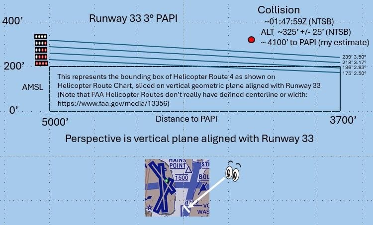
I think the collision was closer to 1250m (4100') from the PAPI. I base that upon the NTSB statement "
At 8:47:58, the crew had a verbal reaction, and FDR (flight data recorder) data showed the airplane beginning to increase its pitch. Sounds of impact were audible about one second later,"
That puts the collision at about 8:47:59 (01:47:59Z). ADS-B Exchange data at that time puts the ground distance to the PAPI between 1200-1280m (3900-4200'). My assumptions are that the NTSB statement is correct and that the ADS-B Exchange data is accurate (which in my experience, the times are generally less than 0.2 seconds later than the timestamps on data collected by the FAA, and the reported NACp (position accuracy) was estimated at < 10m). Here is the graphical representation I generated of my estimated collision position vs. PAPI.
Collision Altitude vs PAPI
Originally Posted by
galaxy flyer
Having been in a mid-air collision with similar geometry, I would bet it was only normal input to approach path. FDR’s are incredibly sensitive recorders. I have a vague memory of the other plane’s wing flashing by. It looks slow in the videos, but it’s incredibly fast.
If my depiction is accurate, it's hard to see why they would pitch up as normal input to approach path. I think their inputs would have been focused on getting down.
Last edited by airplanecrazy; 11th February 2025 at
06:30
.
Reason: Problem with picture. Awkward phrasing
SubjectsADSB (All)Blackhawk (H-60)FAANTSB
Links are to this post in the relevant subject page so that this post can be seen in context.
No recorded likes for this post (could be before pprune supported 'likes').
The helicopter should never have been allowed to be that close to landing traffic,
absolutely . the altimeter talk is just a distraction or at best contributing factor, Not the cause .. which brings us back to the safety assessment of the procedure , which the NTSB did not mention at all,, but I am sure , or at least I hope they will go into in their final report.
In any case the procedure us currently withdrawn until end of March and I sincerely doubt they will re-install it before the final report is out. ..
A couple of new info points the NTSB clarified : Both aircraft were on VHF , so we can drop this UHF discussion , the Blackhawk had ADS-B equipped but was not transmitting , it was check ride with NVG, and they most probably all had them on .and there was a last second evasive action attempt by the CRJ crew, which go a TA previously . On the TWR, the CAs are displayed in the BRITE even with audio on ..
For the rest we have to wait until the next NTSB briefing
As someone with an insight into the complexities of retrofitting certified avionics hardware and the associated wiring, controllers and antennae to fighter jets and other military aircraft, I would be completely unsurprised if, as seems to be evident from the video imbedded at #1112, the USA’s elite, pre-eminent military aerobatics team uses a portable ADS-B unit velcro’ed to the aircraft’s glare shield. And if it’s OK for them, I can’t see why it wouldn’t be OK for the PAT helicopters and I wouldn’t be surprised if that’s the ADS-B to which various references having been made.
I suppose the operational question is whether the aircraft on which these portable units are used are permitted to fly without them on board and working. My guess is that there will be no prohibition. They are just ‘nice to haves’ but not essential for the ops in which they engage.
And there’s a causal question anyway: Would a functioning ADS-B system – portable or otherwise - on the PAT helo have made any difference? The answer depends on the variables around the alert suppression parameters in each aircraft’s systems and the effectiveness of the format of alerts – if any – given in each cockpit.
SubjectsADSB (All)
Links are to this post in the relevant subject page so that this post can be seen in context.
No recorded likes for this post (could be before pprune supported 'likes').
As someone with an insight into the complexities of retrofitting certified avionics hardware and the associated wiring, controllers and antennae to fighter jets and other military aircraft, I would be completely unsurprised if, as seems to be evident from the video imbedded at #1112, the USA\x92s elite, pre-eminent military aerobatics team uses a portable ADS-B unit velcro\x92ed to the aircraft\x92s glare shield. And if it\x92s OK for them, I can\x92t see why it wouldn\x92t be OK for the PAT helicopters and I wouldn\x92t be surprised if that\x92s the ADS-B to which various references having been made.
I suppose the operational question is whether the aircraft on which these portable units are used are permitted to fly without them on board and working. My guess is that there will be no prohibition. They are just \x91nice to haves\x92 but not essential for the ops in which they engage.
And there\x92s a causal question anyway: Would a functioning ADS-B system \x96 portable or otherwise - on the PAT helo have made any difference? The answer depends on the variables around the alert suppression parameters in each aircraft\x92s systems and the effectiveness of the format of alerts \x96 if any \x96 given in each cockpit.
For us lowly civilians a Velcro ADS-B receiver isn't getting you within 30 miles of KDCA, you need it to transmit too. The helicopter having even receive ADS-B would have helped hugely if they looked at it, the fact they weren't looking at the plane they thought they were would have been pretty apparent.
SubjectsADSB (All)KDCA
Links are to this post in the relevant subject page so that this post can be seen in context.
No recorded likes for this post (could be before pprune supported 'likes').
For us lowly civilians a Velcro ADS-B receiver isn't getting you within 30 miles of KDCA, you need it to transmit too. The helicopter having even receive ADS-B would have helped hugely if they looked at it, the fact they weren't looking at the plane they thought they were would have been pretty apparent.
Who said \x93receiver\x94 alone? I think you\x92ll find that those units transmit as well. I have a similar unit clipped to a suction cup on the windscreen of my aircraft.
What they could have seen and heard in the PAT helo depends on a lot on the matters to which I referred, among others, in my earlier post.
SubjectsADSB (All)KDCA
Links are to this post in the relevant subject page so that this post can be seen in context.
No recorded likes for this post (could be before pprune supported 'likes').
The one I use looks similar but is a different brand and is a
portable ADS-B In/Out transceiver
. Looks like it's not compatible with whatever systems are in use in the USA.
But I reiterate that w
hat they could have seen and heard in the PAT helo, had it been fitted with an ADS-B "receiver" depends a lot on the matters to which I referred, among others, in my earlier post.
Last edited by Lead Balloon; 16th February 2025 at
06:33
.
SubjectsADSB (All)
Links are to this post in the relevant subject page so that this post can be seen in context.
No recorded likes for this post (could be before pprune supported 'likes').
Apologies on not using accurate terminology wrt being stepped up solutions but;
the technology is available to stop dual transmissions, even a warning light in the cockpit (ATC station).when simultaneous transmissions are being made would help safety.
On the collision avoidance technology the CAA gave a grant of \xa3250 towards the cost of approved FLARM devices one of which I have - XC TRACER MAXX - which also has FANET.
The swiss invented FLARM nearly 30 years ago and marketed it at cost; it has been obligatory in France for glider operations for the last decade. According to the CAA website it is better than the ADS-B out.
The telecommunication industry has come a long way from the necessity of climbing into the electrical bay and re racking or thumping a radio module but basic cockpit radio procedures haven’t.
What appears to be also relevant is the language and associated phraseology; there was a narrow airmiss in Dublin between an executive jet on take off and a private helicopter pilot caused by ambiguous crossing clearance issued - cross behind the rolling aircraft IIRC which the helicopter pilot took to mean the aircraft rolling down the runway after landing whereas the controller meant the executive jet about to roll; the copilot stuffed the stick forward after take off and passed underneath helicopter.
In this accident I presume that all were Americans; flying around a southern French airfield the controller standard can be diabolical.
How did the top many measures that are in place to prevent this not prevent this?
TCAS
ATC
ADS-B
See and Avoid
Filing a flight plan
Not operating in controlled airspace without a transponder
Not operating at a landing altitude for aircraft on final for a well used runway
Announcing an intention to cross a well used approach
Position lights/strobes
Landing lights
Just spitballing, but there's a non-zero chance NVGs were in use in the helicopter.
It sucks that the best part of this is the airplane was a CRJ, not a larger airliner. Most all those passengers would have survived the initial collision and been aware during the fall to the river.
I feel rage.
Here you go. I feel rage too. And I'm willing to bet that those responsible are not held to account. You can hear the, "we've looked at this and there are definitely changes we can make to increase the safety in this airspace" being warmed up. I looked at the other heliroutes charts for the US around NY & Boston, and I can't see any minimum or maximum altitudes at all. I'm sure someone who knows these areas can point out what I'm missing. But if I'm not missing anything, then it's a sign that the bare minimum is put out there for guidance, and the people who are trying to make the best of it will be hung out to dry.
So the message for everyone is to politely and firmly refuse to do things that are not in your own interest, to make copious reports through safety management systems of events that you see that breach the normal, and to stop trying to work around a broken system where you ultimately will be the scapegoat.
Last edited by Wide Mouth Frog; 17th February 2025 at
01:37
.
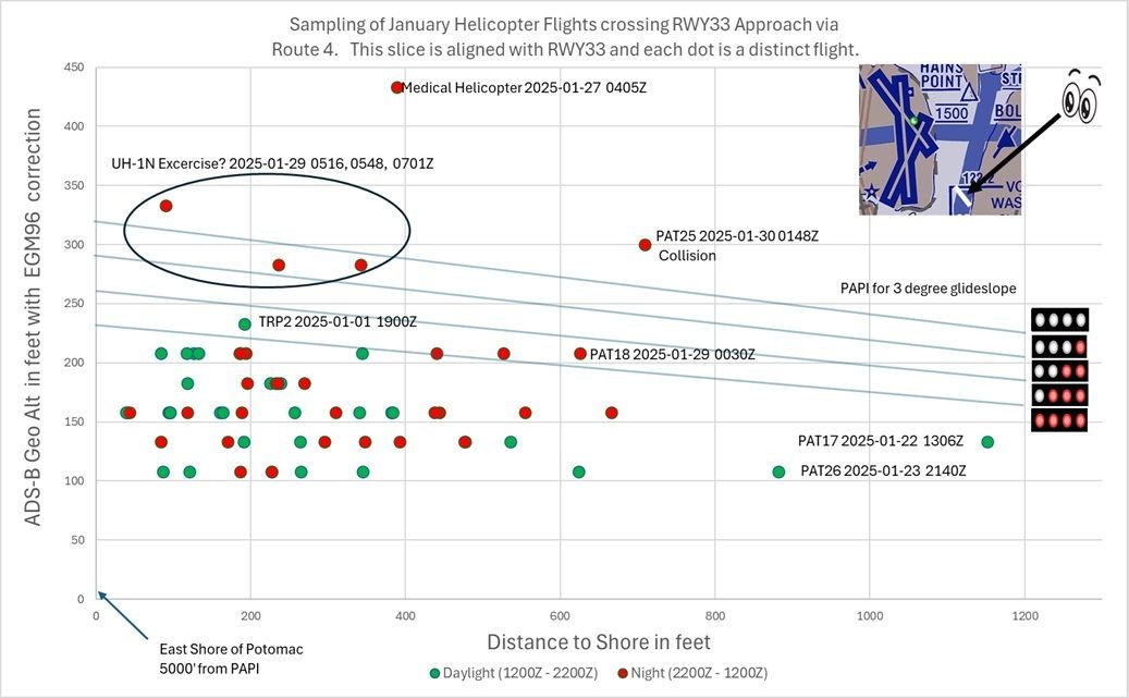
Out of curiosity, I was wondering how \x93out of the ordinary\x94 the flight path was for PA25 compared to other flights along Route 4. I found 65 such flights in January (there are probably some I missed) and I plotted where they crossed the runway approach. Note that the altitude is binned in 25' chunks, so you should assume that all altitudes just above 200' were actually at 200'. For any aircraft above 200' I DID NOT try to determine if they received clearance from ATC (which is permitted), and you SHOULD NOT assume that they didn't. I also threw in a rough breakout between daylight and night for each crossing. For the two PAT flights well offshore, I did not investigate any special ATC clearances they had. I apologize in advance for any errors as it is a bit tricky to plot and measure these distances.
Added note: The chart shows only crossings collected with ADS-B. I threw out all MLAT collected crossing because of inherent inaccuracy.
Helicopters crossing RWY 33 approach via Route 4 for January
Last edited by airplanecrazy; 19th February 2025 at
22:26
.
SubjectsADSB (All)ATCRoute 4
Links are to this post in the relevant subject page so that this post can be seen in context.
Note that the altitude is binned in 25' chunks, so you should assume that all altitudes just above 200' were actually at 200'.
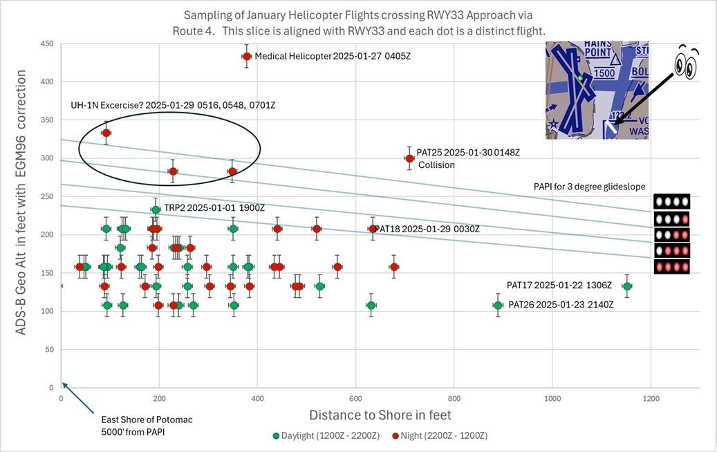
I really like your diagram: it presents data in a way that tells a coherent and compelling story. However I don't agree with the assumption above. A better assumption is that the geo altitude at each point is the recorded value, plus or minus 12.5 feet. Assuming you have built this in Excel, it will be easy to put error bars of that size on each of your data points.
(I've assumed that the altitude is recorded in the closest bin to the actual value. If that's not the case then the error bars would be 25 feet in one direction or the other depending on whether it rounds up or down. An ADSB geek would know. I am also itching to know whether the origin point of your glidepath lines has been adjusted to the same EGM96 height datum as the ADSB values...)
SubjectsADSB (All)
Links are to this post in the relevant subject page so that this post can be seen in context.
No recorded likes for this post (could be before pprune supported 'likes').
Out of curiosity, I was wondering how “out of the ordinary” the flight path was for PA25 compared to other flights along Route 4. I found 65 such flights in January (there are probably some I missed) and I plotted where they crossed the runway approach. Note that the altitude is binned in 25' chunks, so you should assume that all altitudes just above 200' were actually at 200'. For any aircraft above 200' I DID NOT try to determine if they received clearance from ATC (which is permitted), and you SHOULD NOT assume that they didn't. I also threw in a rough breakout between daylight and night for each crossing. For the two PAT flights well offshore, I did not investigate any special ATC clearances they had. I apologize in advance for any errors as it is a bit tricky to plot and measure these distances.
Added note: The chart shows only crossings collected with ADS-B. I threw out all MLAT collected crossing because of inherent inaccuracy.
Helicopters crossing RWY 33 approach via Route 4 for January
Did you take QNH into account ? Ads-B gives pressure altitude
Interesting to note that, had PAT25 been at 200 ft and the CRJ just slightly below nominal glideslope, they would have collided too.
And that, had the CRJ been on the glide slope, it would have been way below PAT25 and would not have collided
Last edited by Senior Pilot; 20th February 2025 at
04:17
.
Reason: Tidy up
SubjectsADSB (All)ATCCRJPAT25QNHRoute 4
Links are to this post in the relevant subject page so that this post can be seen in context.
No recorded likes for this post (could be before pprune supported 'likes').
I really like your diagram: it presents data in a way that tells a coherent and compelling story. However I don't agree with the assumption above. A better assumption is that the geo altitude at each point is the recorded value, plus or minus 12.5 feet. Assuming you have built this in Excel, it will be easy to put error bars of that size on each of your data points.
(I've assumed that the altitude is recorded in the closest bin to the actual value. If that's not the case then the error bars would be 25 feet in one direction or the other depending on whether it rounds up or down. An ADSB geek would know. I am also itching to know whether the origin point of your glidepath lines has been adjusted to the same EGM96 height datum as the ADSB values...)
Thanks for the suggestion. I am not a GPS expert either, but it is easy to defend error bars of at least 10' horizontal and 15' vertical (based upon both ADS-B quantization and inherent GPS resolution). I have updated the chart below with those error bars below, and I will update it again if an expert gives me better values. Given your feedback, I would change my statement to say that all depicted values near 200' are consistent with the aircraft being at or below 200', and readers should not assume those flights exceeded the limit.
As for your question on the glideslope, I did NOT properly account for the EGM96 correction. The new chart moves the glideslope up 5' to meet the height of the PAPI as measured in Google Earth (18'), which uses EGM96. Is that reasonable? I should also add a couple of feet to account for the height of the PAPI lights themselves. Does anyone know how much I should add? Thanks for the catch.
Helicopters crossing RWY 33 approach via Route 4 for January (updated)
Last edited by airplanecrazy; 19th February 2025 at
23:49
.
Reason: Adjusted PAPI lights up 5 feet
SubjectsADSB (All)Route 4
Links are to this post in the relevant subject page so that this post can be seen in context.
Did you take QNH into account ? Ads-B gives pressure altitude
I used ADS-B reported GEO Altitude as my source and added the EGM96 correction for the lat/long of KDCA. Given that, nothing in the chart is derived from pressure altitude. As an aside, I did take a look at QNH adjusted pressure altitude (to get calibrated altitude) and it was largely in agreement with Geo Altitude. The exceptions were two helicopters N11PP and N22PP, and I don't know if it is something I am doing wrong in my calculations or something wrong with their ADS-B equipment.
SubjectsADSB (All)KDCAQNH
Links are to this post in the relevant subject page so that this post can be seen in context.
No recorded likes for this post (could be before pprune supported 'likes').
I used ADS-B reported GEO Altitude as my source and added the EGM96 correction for the lat/long of KDCA. Given that, nothing in the chart is derived from pressure altitude. As an aside, I did take a look at QNH adjusted pressure altitude (to get calibrated altitude) and it was largely in agreement with Geo Altitude. The exceptions were two helicopters N11PP and N22PP, and I don't know if it is something I am doing wrong in my calculations or something wrong with their ADS-B equipment.
GEO Altitude ?
SubjectsADSB (All)KDCAQNH
Links are to this post in the relevant subject page so that this post can be seen in context.
No recorded likes for this post (could be before pprune supported 'likes').
Geometric altitude in ADS-B is GNSS derived and is inherently imprecise - offsets by hundreds of feet are not uncommon. When making these kinds of analyses, you need to use the ADS-B barometric altitude, and correct for the QNH and temperature at that time, using the standard altimetry formulae to obtain AMSL. Aircraft altimeters in order to be serviceable have to indicate correct within +/-60ft of pressure altitude, between 0 and 30'000ft. ADS-B encoding reduces the resolution to 25ft as you've noticed.
SubjectsADSB (All)QNH
Links are to this post in the relevant subject page so that this post can be seen in context.
At night, pretty near impossible to distinguish a CRJ from another set of lights in the stream unless you know the landing light configuration of each type. During the day, maybe a couple of miles. Otherwise, it’s all about, “At your 11 o’clock, 3 miles and third in the stream”, then you can identify them, not by type but by “third on final”. The Army crew is just whistling Dixie when they accept visual separation with an CRJ seven miles away at night.
I am just a lowly multi/commercial pilot who flies mostly for recreation. Since the advent of ADS-B, we have had much more precise information on what traffic is around us, what type they are, and exactly what they are doing heading/altitude/speed-wise. With that data, I've noted that even when I know EXACTLY where to look for a specific type of traffic during daylight hours, for example over an easy to identify landmark, I generally need to be within 3 miles or so to be able to reliably spot it amongst ground clutter and terrain. I'd need to be considerably closer in order to identify a specific type. At night you might be able spot some traffic from further away, but as you note it s even more difficult to determine the type. In the past you might be able to know you were looking for a CRJ and therefore eliminate the Cessna Skyhawk with a single PAR36 incandescent bulb. But these days I have a friend with a Skyhawk that has a LED in the nose, wig-wag LEDs in the wingtips, and Airbus style double flash strobes, and that thing looks like a much larger aircraft at night now. Or maybe like a UFO.
Nice but you have to have it and not sure of the H-60 fit. Besides, I don’t think you can declare visual using only ADS info
I don't think he was proposing doing that, more like that once you have ADS-B and can correspond what you see to the exact airplane you are looking for, you learn how hard it is to identify type a long way off. Also his other point about night lighting is valid, now even the lowest C-150 from the back row can have strobes and LEDs galore, if it ever was possible to identify type at night at a distance it isn't any more.
SubjectsADSB (All)
Links are to this post in the relevant subject page so that this post can be seen in context.
Nice but you have to have it and not sure of the H-60 fit. Besides, I don\x92t think you can declare visual using only ADS info
Please re-read my post. It had absolutely nothing to do with using ADS-B to identify traffic.
It was about the difficulty of being able to visually identify traffic beyond approximately 3 miles, and therefore the lack of useful information when ATC tells me I have traffic at 6 o clock and 10 miles. I don\x92t have a rear view mirror in this particular aircraft and I can\x92t see that far.
What percentage of day VMC traffic point-outs can you typically get a visual on? I\x92d estimate 50-50 for me.
SubjectsADSB (All)ATC
Links are to this post in the relevant subject page so that this post can be seen in context.
No recorded likes for this post (could be before pprune supported 'likes').