February 16, 2025, 09:42:00 GMT
permalink Post: 11829100
Last edited by Easy Street; 16th February 2025 at 10:32 .
Subjects
ATC
Night Vision Goggles (NVG)
Separation (ALL)
Visual Separation
Links are to this post in the relevant subject page so that this post can be seen in context.
Reply to this quoting this original post. You need to be logged in. Not available on closed threads.
February 16, 2025, 11:53:00 GMT
permalink Post: 11829182
the technology is available to stop dual transmissions, even a warning light in the cockpit (ATC station).when simultaneous transmissions are being made would help safety.
On the collision avoidance technology the CAA gave a grant of \xa3250 towards the cost of approved FLARM devices one of which I have - XC TRACER MAXX - which also has FANET.
The swiss invented FLARM nearly 30 years ago and marketed it at cost; it has been obligatory in France for glider operations for the last decade. According to the CAA website it is better than the ADS-B out.
The telecommunication industry has come a long way from the necessity of climbing into the electrical bay and re racking or thumping a radio module but basic cockpit radio procedures haven’t.
What appears to be also relevant is the language and associated phraseology; there was a narrow airmiss in Dublin between an executive jet on take off and a private helicopter pilot caused by ambiguous crossing clearance issued - cross behind the rolling aircraft IIRC which the helicopter pilot took to mean the aircraft rolling down the runway after landing whereas the controller meant the executive jet about to roll; the copilot stuffed the stick forward after take off and passed underneath helicopter.
In this accident I presume that all were Americans; flying around a southern French airfield the controller standard can be diabolical.
Subjects
ADSB (All)
ADSB Out
ATC
Phraseology (ATC)
Links are to this post in the relevant subject page so that this post can be seen in context.
Reply to this quoting this original post. You need to be logged in. Not available on closed threads.
February 16, 2025, 13:02:00 GMT
permalink Post: 11829223
ATC works very well. All efforts are made to avoid any confliction from the flight plan stage to the tactical stage - most of the time.
Pilots develop an awareness of other aircraft around them by listening to the RT, watching TCAS / Wx radar and looking out. This is most useful in understanding complicated situations - most of the time.
Even when the odd situation occurs where time and ideas run out and things are tight, people get away with it - most of the time.
But - not all the time. The Tenerife crash for instance involved a double transmission. One aircraft in extremis stuck on the foggy runway, trying desperately to stop the other rolling, while a tower communication took place and the RT was jammed. The question is, do we want to plan for these rare last second occurrences? I would guess yes - same philosophy as with GPWS and TCAS. We should have a means of communicating where an priority transmission overrides other radio traffic. There will be many who can explain why this can't be done, impossible, too expensive or unworkable. I am not here to explain in this modern and digital World how it should be done but you young bloods should suss out fairly quickly how it could be done. (spoiler - don't forget the open guard box)
Subjects
ATC
Radar
TCAS (All)
Links are to this post in the relevant subject page so that this post can be seen in context.
Reply to this quoting this original post. You need to be logged in. Not available on closed threads.
February 16, 2025, 18:49:00 GMT
permalink Post: 11829389
Altimetry and height keeping would be important matters for investigators if the collision had occurred due to a breakdown in vertical separation, which as a minimum would involve 500 feet (and more often 1000 feet) of planned spacing to account for instrument and height keeping errors. FAA instrument rating standards require pilots to be able to maintain altitude plus or minus 100 feet. This helicopter was being flown VFR at very low height, which means that looking outside takes primacy over monitoring instruments. I'm sure helo pilots could fly along at 175ft plus or minus 25ft if they really tried, but you can be certain they wouldn't be looking out for traffic (as required when taking visual separation).
However, as there was no vertical separation built into this procedure, all of this is at best a distraction. The more important questions are why procedural barriers were not in place to stop the route being used during landings on runway 33, and whether visual separation at night is an adequate barrier to collision when airliners and their human cargo are involved.
N123, do you see the closest plane lined up, pass right below and behind him and never mind all the other planes right behind. Ah......NO.
There is night visual and there is night nutty visual. The first example leaves a lot of room for error and time for ATC to see if it is going wrong.
Subjects
ATC
CRJ
FAA
PAT25
Pass Behind
Pass Behind (All)
Separation (ALL)
VFR
Vertical Separation
Visual Separation
Links are to this post in the relevant subject page so that this post can be seen in context.
Reply to this quoting this original post. You need to be logged in. Not available on closed threads.
February 16, 2025, 20:39:00 GMT
permalink Post: 11829445
Subjects
ATC
VFR
Links are to this post in the relevant subject page so that this post can be seen in context.
Reply to this quoting this original post. You need to be logged in. Not available on closed threads.
February 16, 2025, 22:53:00 GMT
permalink Post: 11829514
Subjects
ATC
CRJ
Night Vision Goggles (NVG)
Pass Behind
Pass Behind (All)
Separation (ALL)
Links are to this post in the relevant subject page so that this post can be seen in context.
Reply to this quoting this original post. You need to be logged in. Not available on closed threads.
February 16, 2025, 23:07:00 GMT
permalink Post: 11829527
So maybe the handling pilot misread 300ft radio and set an indicated 210ft on her baro-altimeter, while the pilot monitoring correctly set 300ft on his baro-altimeter, but without a crosscheck being performed. Subsequently if they adjusted flightpath to fly 200ft on the handling pilots baro alt then that would explain quite a lot\x85.
eg The helicopter flying at 290ft radio (actually 278ft at impact); the pilot monitoring\x92s nudge to the pilot handling to descend a bit; the transponder mode C reporting 300ft from the pressure altitude capsule in the handling pilots baro altimeter (which we\x92ve seen on the various ATC traffic videos).
Subjects
ATC
Altimeter (All)
Radio Altimeter
Links are to this post in the relevant subject page so that this post can be seen in context.
Reply to this quoting this original post. You need to be logged in. Not available on closed threads.
February 17, 2025, 01:03:00 GMT
permalink Post: 11829565
TCAS
ATC
ADS-B
See and Avoid
Filing a flight plan
Not operating in controlled airspace without a transponder
Not operating at a landing altitude for aircraft on final for a well used runway
Announcing an intention to cross a well used approach
Position lights/strobes
Landing lights
Just spitballing, but there's a non-zero chance NVGs were in use in the helicopter.
It sucks that the best part of this is the airplane was a CRJ, not a larger airliner. Most all those passengers would have survived the initial collision and been aware during the fall to the river.
I feel rage.
So the message for everyone is to politely and firmly refuse to do things that are not in your own interest, to make copious reports through safety management systems of events that you see that breach the normal, and to stop trying to work around a broken system where you ultimately will be the scapegoat.
Last edited by Wide Mouth Frog; 17th February 2025 at 01:37 .
Subjects
ADSB (All)
ATC
CRJ
Night Vision Goggles (NVG)
See and Avoid
TCAS (All)
Links are to this post in the relevant subject page so that this post can be seen in context.
Reply to this quoting this original post. You need to be logged in. Not available on closed threads.
February 17, 2025, 01:08:00 GMT
permalink Post: 11829568
Your litany of how the holes in the cheese lined up might be missing a detail or two, but any of those holes not lining up might have avoided this tragedy.
The rad alt is right there.
At night over water at low level, the pilots I flew with did not ignore their rad alt.
It was a part of one's scan.
If I know that field elevation is 14', and my rad alt isn't at 200' or less on a route where max altitude is 200', a correction is needed now, before the error gets larger. (The separate issue of going behind, and that tower guidance apparently being stepped on, is another pair of holes in the cheese).
I am at a loss to understand the apparent magnitude of the altitude error (they were still too close laterally, yes), but as I've been out of the cockpit for a few years I am not aware of what's being taught these days.
On most airlines, they do have a barf bag, still, in the seat pocket in front of you. Suggest you vomit into that and avoid the choke hazard.
Subjects
ATC
CRJ
Night Vision Goggles (NVG)
Pass Behind
Pass Behind (All)
Radio Altimeter
Separation (ALL)
Links are to this post in the relevant subject page so that this post can be seen in context.
Reply to this quoting this original post. You need to be logged in. Not available on closed threads.
February 17, 2025, 02:39:00 GMT
permalink Post: 11829597
So if the Blackhawk pilots either flew this low altitude route regularly, or it was an operational norm for that pilot group/operation, pilots would begin to relax with it - it's "normal" I opine that it is never normal to fly at 200 feet AGL in a built up area, nor close to the approach path for a busy airport. So if the training and operational norms of this routing lead pilots to think it is normal, they treat it that way, and vigilance goes down. This was an accident waiting to happen, because of normalization of deviance form established norms of flying.
I've learned the hard way that when ATC asks if you have X aircraft in sight, once you think you do, mentally map the path of that aircraft, then start looking for the one you have not seen yet - particularly with two pilots! You get a clearance to pass at 200 AGL under the approach path of a busy airport at night - that's unusual, and spidy senses should be tingling lots! This hyper awareness should be being trained into the operation - a preflight briefing from the lead "On this flight, we could expect this routing and clearance. This will be unusual, and we're going to be extra aware by doing the following....".
So it's easy to blame the Blackhawk pilots, and yes, they wear some of this, but the military let the pilots down by not categorizing this flight as "high risk", and ATC let the pilots down by clearing a routing which had the potential to provide only a hundreds of feet vertical separation, rather than insisting on both vertical, lateral, and projected path separation, and thereafter, telling the Blackhawk pilots all of the airplanes they should be seeing, not just the one, which seems to have been misunderstood.
I have been instructed to orbit to allow for a passing aircraft to clear in front of me, why not this time? Maybe that low altitude air route is too small for a normal orbit? Another red lag about that route not being a good idea!
Subjects
ATC
Accident Waiting to Happen
Blackhawk (H-60)
Normalization of Deviance
Separation (ALL)
VFR
Vertical Separation
Links are to this post in the relevant subject page so that this post can be seen in context.
Reply to this quoting this original post. You need to be logged in. Not available on closed threads.
February 17, 2025, 03:42:00 GMT
permalink Post: 11829612
While the PAT 25 pilots, prior to take off, would set the barometric pressure each gauge must have no more than a +/- 75 foot error (FAA). One gauge may have read + 50 feet high while the other one read - 50 feet low which would account for the 100 foot difference in flight between the two barometric altimeters. Many mechanical and pilot input errors would be potential factors. Not common but sometimes a pilot will read back the correct setting while at the same time setting a different value by mistake. IF the 100 foot discrepancy was discussed initially on the ground it may account for the lack of discussion , later in the flight, while at 400 feet PM and 300 feet PF. It begs the question was radar altimeter planned to be used and if so when?
Even though there are some transmissions stepped on for various reasons, the words runway thirty three were mentioned a number of times. As crossing the threshold to runway 33 posed a significant risk to PAT 25 I would have thought the PAT 25 crew, to know from experience, that in 3 to 4 minutes from the time ATC reported the CRJ crossing the bridge the CRJ would pass directly in front of them at or near the same altitude. It's not clear to me why PAT 25 would not have reduced airspeed and or held at HAINS point.
I belive the simultaneous helicopter and runway 33 operations should never have been permitted. Clearance limits and expected further clearance times mirroring the ETA for rwy 33 given to helicopters to arrive at or hold at HAINS point would have be helpful in preventing conflicts.
Subjects
ATC
Altimeter (All)
CRJ
FAA
Night Vision Goggles (NVG)
Radar
Links are to this post in the relevant subject page so that this post can be seen in context.
Reply to this quoting this original post. You need to be logged in. Not available on closed threads.
February 17, 2025, 06:24:00 GMT
permalink Post: 11829650
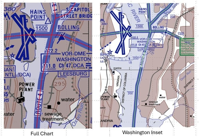
You could reasonably define the bank as the water's edge, and therefore expect crews to fly along an infinitesimally narrow path. Or as the space between the water's edge and the [edge of the flood plain | first flat area | something else], which would imply that the western boundary changes with the water level. Both imply the route is substantially above land.
Neither are useful for precise navigation, but the map and the description are probably 'close enough' if they are only needed for general route guidance and knowing that structures on the east bank need to be NOTAMed for helicopters, but probably not the west bank.
A good reminder that measurements/specifications without tolerance are often worse than useless.
If it quacks like a duck... this kind of "It can't be an X because we can't do it, so we'll call it a Y" leads to a culture that gets used to massaging the truth for convenience. Did we hear more on the Alaska door plug that was an 'opening' not a 'removal'?
Subjects
ATC
CRJ
DCA
FAA
KDCA
NTSB
Night Vision Goggles (NVG)
Pass Behind
Pass Behind (All)
Separation (ALL)
Links are to this post in the relevant subject page so that this post can be seen in context.
Reply to this quoting this original post. You need to be logged in. Not available on closed threads.
February 17, 2025, 13:12:00 GMT
permalink Post: 11829888
Subjects
ATC
Separation (ALL)
VFR
Visual Separation
Links are to this post in the relevant subject page so that this post can be seen in context.
Reply to this quoting this original post. You need to be logged in. Not available on closed threads.
February 17, 2025, 15:07:00 GMT
permalink Post: 11829956
Last edited by Wide Mouth Frog; 17th February 2025 at 15:28 .
Subjects
ATC
FAA
Links are to this post in the relevant subject page so that this post can be seen in context.
Reply to this quoting this original post. You need to be logged in. Not available on closed threads.
February 17, 2025, 15:50:00 GMT
permalink Post: 11829979
As many and I said before, discussion about Altimeters or width of VFR routes are just distractions to deflect from the real cause , which for me can be resumed into the lack of a safety assessment and safety case of existing procedures. We all had to do this when SMS was widely introduced in the late 90s It was not that easy , but we discovered a few holes that were closed.
Here in DCA we see a couple of procedures that would not have passed a safety case : e.g Route 4, Circling to RWY 33 with that route active, visual separation at night , use of NVG on that route ..etc,,
Flying in itself always bares a risk,, our job is to minimize the risk , not to eliminate it , but here the Regulatory ( i.e FAA) failed to minimize the risks.
As in the US the FAA is both the service provider and the Regulator , and is in addition dependent of political will and pressure for its funding , the willingness to implement unpopular measures, may be limited. A Judge might look into this differently but for those part of the discussion I hand over the floor to .Willow run 6-3 .
This is an excerpt from a website of an actually well-known, very accomplished, and respected group of lawyers who specialize in (among other things) aviation matters. I'm not using their name and I don't have any approval, express or implied, to use information from their website - but if justice is to be sought for the victims' families, public discussion is - or should be - encouraged.
"A discretionary function is an action of a governmental nature exercised by a federal employee, but in order for that action to be considered a discretionary function, it must pass a two-part test:
There must be an element of judgment or choice. That is, if a federal statute or regulation prescribes a course of action for an employee to follow, there is no discretion.
That judgment or choice must be susceptible to policy analysis.
The Federal Tort Claims Act contains a discretionary function exception that says the U.S. cannot be held liable for any employee\x92s failure to exercise or perform a discretionary duty.
Within the legal field of aviation accidents, discretionary duties for which the U.S. is not liable include the following:
Aircraft \x93spot check\x94 certifications
Weather forecasting
Failure to install equipment
The FAA\x92s design of flight procedures
The types of actions that are considered not discretionary, and therefore, open the U.S. government to litigation are:
The failure to issue air traffic control manual warnings
If air traffic control fails to warn of weather dangers
The failure to maintain equipment
Relaying incorrect instructions to pilots."
END OF EXCERPT [not intended as legal advice here or on its original internet page]
So to return to ATC Watcher's point...... the more posts I read about this midair collision (plus other information such as NTSB briefings) the more I am anticipating that it will require an act of Congress to provide for compensation for the families of the victims. Isn't it the obvious fact that convenience for people who work in Washington and travel "back home" generally speaking on weekends and when Congress isn't convened, is a prime and central reason for the way DCA airspace has been constructed and managed? Is it really going to be the case that because the lawsuits will - in all likelihood - fail to overcome the "discretionary function" exception, that the 67 families will be without a remedy? Is that how it works, then?
In case anyone thinks my sense of being horrified at this accident is clouding reason or logic, consider this - the book Collision Course discusses the PATCO union's genesis, the strike, and so on. PATCO's earliest stirrings resulted in large part from the 1960 midair over New York. Is the United States aviation sector willing to accept an outcome of this accident that in effect travels back over six decades? The point is, given the long-term shortage of ATCOs in this country . . . I don't think a court is capable of ruling that the situation, allowed and in fact enabled by Congress and successive White House presidential administrations, is subject to "negligence" analysis in the currently applicable legal sense. All this being said, this is how I arrive at thinking that in the interests of justice, some other means of providing for the loved ones of 67 souls who were on board needs to be determined and implemented.
Last edited by WillowRun 6-3; 17th February 2025 at 19:11 .
Subjects
ATC
DCA
FAA
NTSB
Night Vision Goggles (NVG)
Route 4
Separation (ALL)
VFR
Visual Separation
Links are to this post in the relevant subject page so that this post can be seen in context.
Reply to this quoting this original post. You need to be logged in. Not available on closed threads.
February 17, 2025, 20:56:00 GMT
permalink Post: 11830154
For a landing aircraft on Rwy33, and assuming:
(1) correct QNH dialed in
(2) perfect centerline following
(3) perfect 3deg PAPI following
baro altitude would be 278 ft exactly above the east bank. And 200 baro altitude would come appr. 1.175 ft from the east bank and over the water.
Very hard to believe that aircrafts were routinely allowed to cross simultaneously this crossing. Statistically, the accident would have happened long ago, or at, the least, have reports filed (even from passengers) and brown underwear.
And btw, even top VIP seems that are considered much more expendable than we originally thought.
Think of it like a road with a traffic light (ATC) but you can merge on red if you can see it\x92s clear (helicopter). No rotary pilot I know would knowingly pass that close under/behind a jet transport as the wake could literally be the end of you at 200\x92AGL.
Subjects
ATC
QNH
Radar
Separation (ALL)
Links are to this post in the relevant subject page so that this post can be seen in context.
Reply to this quoting this original post. You need to be logged in. Not available on closed threads.
February 17, 2025, 21:32:00 GMT
permalink Post: 11830196
Here if you want to learn or just refresh your memory ; https://www.latimes.com/archives/la-...%20government.
As an aside , the NTSB conclusions of that collision are interesting compared to our DCA accident : ( exactly 40 years ago !)
Subjects
ATC
DCA
FAA
NTSB
Probable Cause
Route 4
See and Avoid
Separation (ALL)
Links are to this post in the relevant subject page so that this post can be seen in context.
Reply to this quoting this original post. You need to be logged in. Not available on closed threads.
February 18, 2025, 08:00:00 GMT
permalink Post: 11830516
I wouldn't put it past the FAA to pull a stunt like that, read Mary Schiavo's (ex IG of the Dept. of Transportation) book if you want to know how wily they can be. And Jennifer gave them the perfect lay up in the last briefing.
It's way to easy to blame the pilots, over the years there have been incidents due to incorrect QNH settings, were both pilots and ATC have failed to catch the error, in a busy airspace with overworked ATC, late change of runway for airlines, and military helicopters using Night Vision Goggles, altimeter equipment failure/error.
Even the Max 200 ft altitude under the approach to a major US airport is an accident waiting to happen, and whoever approved this to be used during normal operations should be investigated. The CRJ was at around 325 ft on a visual/circling approach when it crashed, does anyone really think it's great airmanship to have a Black Hawk helicopter at 200 ft passing under you?
That's what made the Swiss Cheese model line up perfectly, a planned approved separation of 125 ft was the "best case" scenario.
Subjects
ATC
Accident Waiting to Happen
Altimeter (All)
Blackhawk (H-60)
CRJ
FAA
QNH
Separation (ALL)
Links are to this post in the relevant subject page so that this post can be seen in context.
Reply to this quoting this original post. You need to be logged in. Not available on closed threads.
February 18, 2025, 09:11:00 GMT
permalink Post: 11830561
Subjects
ATC
Links are to this post in the relevant subject page so that this post can be seen in context.
Reply to this quoting this original post. You need to be logged in. Not available on closed threads.
February 18, 2025, 11:48:00 GMT
permalink Post: 11830679
How do you boil a frog? Just like this. Obe degree at a time. This is the B-17/P63 crash- dumb orchestration, no one spoke up.
Subjects
ATC
Links are to this post in the relevant subject page so that this post can be seen in context.
Reply to this quoting this original post. You need to be logged in. Not available on closed threads.