February 01, 2025, 03:34:00 GMT
permalink Post: 11818738
1. The CRJ was on approach to 1 and then was asked to divert to 33. They complied, which added to their workload. From what I understand, that runway is rarely used for commercial aircraft. So, ATC added to the CRJ's workload while introducing and "unusual event." The CRJ crew appears to have acted professionally in changing their approach.
2. ATC didn't hold the helo short of the runway path, instead relied on them to correctly identify an aircraft, at night, over an urban area. That introduced a "single point of failure" to an already complex situation.
3. There was no way for the helo to pass safely under the CRJ at the altitude of impact.
3. I don't recall hearing ATC asking the CRJ if they could see the helo, though they already overtasked them. At that point, I don't think they could do anything at that point to prevent the collision.
Other factors may come into play, such as if ATC was properly staffed that night. I've read that DCA had two incidents that week where an aircraft had to perform a "go around" because of helo traffic. Also, was the CRJ's TCAS system operational?
This was completely preventable if things work they way they're supposed to.
Everything else is moot, really...
Subjects
ATC
CRJ
DCA
FAA
Separation (ALL)
TCAS (All)
Visual Separation
Links are to this post in the relevant subject page so that this post can be seen in context.
Reply to this quoting this original post. You need to be logged in. Not available on closed threads.
February 01, 2025, 03:45:00 GMT
permalink Post: 11818745
Subjects
ATC
Frequency 119.1
Frequency 134.35
Links are to this post in the relevant subject page so that this post can be seen in context.
Reply to this quoting this original post. You need to be logged in. Not available on closed threads.
February 01, 2025, 09:03:00 GMT
permalink Post: 11818857
No, I don't think he was overwhelmed. He was shot through with adrenaline and shocked as anyone would be having just witnessed two aircraft he was talking to seconds before vanish in a fireball, realising his career, reputation, life and future sanity was irrevocably blown to pieces no matter the cause.
No, no and thrice no. Assuming the tapes are in real time there are considerable gaps between transmissions so he most certainly did not 'have' to speak so quickly. He had plenty of time to speak clearly and coherently instead of spouting those eruptions of incoherent, almost incomprehensible babble.
Sadly - reprehensibly, this style of unnecessarily theatrical auctioneer-style unpunctuated babble seems all too frequent in the States. Tower frequencies are usually if not almost invariably much less time-pressurised as they handle fewer aircraft in a well spaced sequence than in a termnal control area.
6) Concur 100%. And they failed miserably to achieve this. I've been flying for several decades and struggle to hear one word in three (and only assume much of the rest because I know what to expect - a human factors disaster) of that controller's outbursts, and the shoddy partial readbacks are shocking to European ears.
hear hear - spot on
on our rare jollies to the states reading back clearances , to avoid going to the sin bin , was always a challenge.
as I can’t see anything changing soon
SUGGEST as a training aid ATC tapes in various countries are provided and studied PRE FLIGHT so at least you have a chance of understanding some local eccentricities/ accents.
Subjects
ATC
Links are to this post in the relevant subject page so that this post can be seen in context.
Reply to this quoting this original post. You need to be logged in. Not available on closed threads.
February 01, 2025, 11:51:00 GMT
permalink Post: 11818965
The mission continues till today and shall continue as it is an essential national security concern.
Subjects
ATC
Links are to this post in the relevant subject page so that this post can be seen in context.
Reply to this quoting this original post. You need to be logged in. Not available on closed threads.
February 01, 2025, 12:29:00 GMT
permalink Post: 11818990
.
Subjects
ATC
Links are to this post in the relevant subject page so that this post can be seen in context.
Reply to this quoting this original post. You need to be logged in. Not available on closed threads.
February 01, 2025, 13:34:00 GMT
permalink Post: 11819025
Subjects
ATC
Links are to this post in the relevant subject page so that this post can be seen in context.
Reply to this quoting this original post. You need to be logged in. Not available on closed threads.
February 01, 2025, 13:35:00 GMT
permalink Post: 11819026
The helicopter crew is said to have had NVG's but at this point no information has been provided re their use of NVG's.
The height issue is not the primary issue as the intent of the procedures and ATC instructions was to separate the two aircraft.
Had that separation effort worked there would have been no conflict thus no collision.
It is the failure of the separation and the meeting over the river the two aircraft in the same bit of air that height mattered.
No where in the standard procedure was it intended to have helicopter traffic fly below landing aircraft on RWY 33.
Poll the Pilots here folks....ask them if they would routinely fly 100-200 feet below a crossing aircraft? What do you think the answer would be?
I thank 212 Man for his input reminding me why he was the Teacher's Pet. I depend upon his ability to get into the books to keep me straight.
Now a test question for him.....were you flying the incident airplane doing a Visual Approach to RWY33....would you have tuned up the IAP for that RWY as an additional reference for your approach?
SOP's usually instruct Crews to use ILS data when doing Visual Approaches to runways with that kind of IAP so would that kind of thinking apply in this incident? Would that have been of any benefit considering the existing weather and terrain? Or, would that have been a distraction?
This was not a "Circling Approach" but it was very similar.
Subjects
ATC
Circle to Land (Deviate to RWY 33)
Night Vision Goggles (NVG)
Separation (ALL)
Links are to this post in the relevant subject page so that this post can be seen in context.
Reply to this quoting this original post. You need to be logged in. Not available on closed threads.
February 01, 2025, 14:03:00 GMT
permalink Post: 11819042
Subjects
ATC
CRJ
Separation (ALL)
Visual Separation
Links are to this post in the relevant subject page so that this post can be seen in context.
Reply to this quoting this original post. You need to be logged in. Not available on closed threads.
February 01, 2025, 14:06:00 GMT
permalink Post: 11819045
That\x92s why using their recordings leads to comments on pprune that the controller was cut off or didn\x92t say something or the aircraft didn\x92t acknowledge. It can be just the scanner not picking it up, because it focuses on one transmission at a time.
That\x92s not to comment on whether they had VHF or not.
Subjects
ATC
Links are to this post in the relevant subject page so that this post can be seen in context.
Reply to this quoting this original post. You need to be logged in. Not available on closed threads.
February 01, 2025, 14:12:00 GMT
permalink Post: 11819054
The helicopter crew is said to have had NVG's but at this point no information has been provided re their use of NVG's.
The height issue is not the primary issue as the intent of the procedures and ATC instructions was to separate the two aircraft.
Had that separation effort worked there would have been no conflict thus no collision.
It is the failure of the separation and the meeting over the river the two aircraft in the same bit of air that height mattered.
No where in the standard procedure was it intended to have helicopter traffic fly below landing aircraft on RWY 33.
Poll the Pilots here folks....ask them if they would routinely fly 100-200 feet below a crossing aircraft? What do you think the answer would be?
I thank 212 Man for his input reminding me why he was the Teacher's Pet. I depend upon his ability to get into the books to keep me straight.
Now a test question for him.....were you flying the incident airplane doing a Visual Approach to RWY33....would you have tuned up the IAP for that RWY as an additional reference for your approach?
SOP's usually instruct Crews to use ILS data when doing Visual Approaches to runways with that kind of IAP so would that kind of thinking apply in this incident? Would that have been of any benefit considering the existing weather and terrain? Or, would that have been a distraction?
This was not a "Circling Approach" but it was very similar.
Subjects
ATC
Circle to Land (Deviate to RWY 33)
Night Vision Goggles (NVG)
Separation (ALL)
Links are to this post in the relevant subject page so that this post can be seen in context.
Reply to this quoting this original post. You need to be logged in. Not available on closed threads.
February 01, 2025, 14:16:00 GMT
permalink Post: 11819056
That’s why using their recordings leads to comments on pprune that the controller was cut off or didn’t say something or the aircraft didn’t acknowledge. It can be just the scanner not picking it up, because it focuses on one transmission at a time.
That’s not to comment on whether they had VHF or not.
The tower was transmitting on both frequencies - I believe - simultaneously.
So the CRJ would have heard only the tower's transmissions to the helo ('visual separation approved' x 2) and not the helo's transmissions.
Subjects
ATC
CRJ
Separation (ALL)
Visual Separation
Links are to this post in the relevant subject page so that this post can be seen in context.
Reply to this quoting this original post. You need to be logged in. Not available on closed threads.
February 01, 2025, 14:37:00 GMT
permalink Post: 11819062
Blaming the airspace design is also a non starter. Are we really going to say that just because the airspace is poorly designed then I'm just going to fly in to that regional jet over there?
First rule of airmanship anyone? Keep a good lookout. Seems like the helicopter crew failed to do so having been given their requested visual separation. Should have had eyes on stalks.
No the airspace does not take the blame. Apparently the hello pilots missed the lookout. And the controller could have been clearer, instead of \x93still in sight?\x94 perhaps \x93the RJ is now 1/2 mile 10 o\x92clock, confirm you have him?\x94.
(not criticizing him, guessing that he saw them closer than expected, was concerned, and made a very quick call)
But the airspace & procedure seems to not tolerate mistakes. There ought to be some safety margin. While not the primary fault, it could be improved.
Subjects
ATC
CRJ
Separation (ALL)
Visual Separation
Links are to this post in the relevant subject page so that this post can be seen in context.
Reply to this quoting this original post. You need to be logged in. Not available on closed threads.
February 01, 2025, 14:45:00 GMT
permalink Post: 11819065
Cross-coupling, whereby aircraft transmissions are re-broadcast on the other frequency being used is a mandatory requirement at civil ATC units in UK. This being done to facilitate situational awareness of other traffic by all crews.
It\x92s pretty common in Canada, both at Tower and enroute IFR sectors.
It\x92s not just for situational awareness, also to prevent overlapping transmissions from aircraft on the two frequencies. So you don\x92t have to try to listen to both as the controller.
Even without that the controllers here almost always transmit on all their frequencies rather than just the one the aircraft is on.
Subjects
ATC
IFR
Situational Awareness
TCAS (All)
Links are to this post in the relevant subject page so that this post can be seen in context.
Reply to this quoting this original post. You need to be logged in. Not available on closed threads.
February 01, 2025, 15:30:00 GMT
permalink Post: 11819099
Secondly, why shouldn\x92t we criticise the controller? Imho his actions need to be criticised. Not the individual but the environment, procedures and training he operated in. The mission of ATC is to prevent exactly this from happening and they failed in their mission.
No the airspace does not take the blame. Apparently the hello pilots missed the lookout. And the controller could have been clearer, instead of \x93still in sight?\x94 perhaps \x93the RJ is now 1/2 mile 10 o\x92clock, confirm you have him?\x94.
(not criticizing him, guessing that he saw them closer than expected, was concerned, and made a very quick call)
But the airspace & procedure seems to not tolerate mistakes. There ought to be some safety margin. While not the primary fault, it could be improved.
Subjects
ATC
CRJ
Links are to this post in the relevant subject page so that this post can be seen in context.
Reply to this quoting this original post. You need to be logged in. Not available on closed threads.
February 01, 2025, 16:48:00 GMT
permalink Post: 11819158
The helicopter crew is said to have had NVG's but at this point no information has been provided re their use of NVG's.
The height issue is not the primary issue as the intent of the procedures and ATC instructions was to separate the two aircraft.
Had that separation effort worked there would have been no conflict thus no collision.
It is the failure of the separation and the meeting over the river the two aircraft in the same bit of air that height mattered.
No where in the standard procedure was it intended to have helicopter traffic fly below landing aircraft on RWY 33.
Poll the Pilots here folks....ask them if they would routinely fly 100-200 feet below a crossing aircraft? What do you think the answer would be?
I thank 212 Man for his input reminding me why he was the Teacher's Pet. I depend upon his ability to get into the books to keep me straight.
Now a test question for him.....were you flying the incident airplane doing a Visual Approach to RWY33....would you have tuned up the IAP for that RWY as an additional reference for your approach?
SOP's usually instruct Crews to use ILS data when doing Visual Approaches to runways with that kind of IAP so would that kind of thinking apply in this incident? Would that have been of any benefit considering the existing weather and terrain? Or, would that have been a distraction?
This was not a "Circling Approach" but it was very similar.
Subjects
ATC
Circle to Land (Deviate to RWY 33)
DCA
Night Vision Goggles (NVG)
Separation (ALL)
Links are to this post in the relevant subject page so that this post can be seen in context.
Reply to this quoting this original post. You need to be logged in. Not available on closed threads.
February 01, 2025, 16:56:00 GMT
permalink Post: 11819164
Subjects
ATC
Radar
Separation (ALL)
Vertical Separation
Links are to this post in the relevant subject page so that this post can be seen in context.
Reply to this quoting this original post. You need to be logged in. Not available on closed threads.
February 01, 2025, 17:04:00 GMT
permalink Post: 11819170
Secondly, why shouldn\x92t we criticise the controller? Imho his actions need to be criticised. Not the individual but the environment, procedures and training he operated in. The mission of ATC is to prevent exactly this from happening and they failed in their mission.
Subjects
ATC
CRJ
Links are to this post in the relevant subject page so that this post can be seen in context.
Reply to this quoting this original post. You need to be logged in. Not available on closed threads.
February 01, 2025, 17:18:00 GMT
permalink Post: 11819178
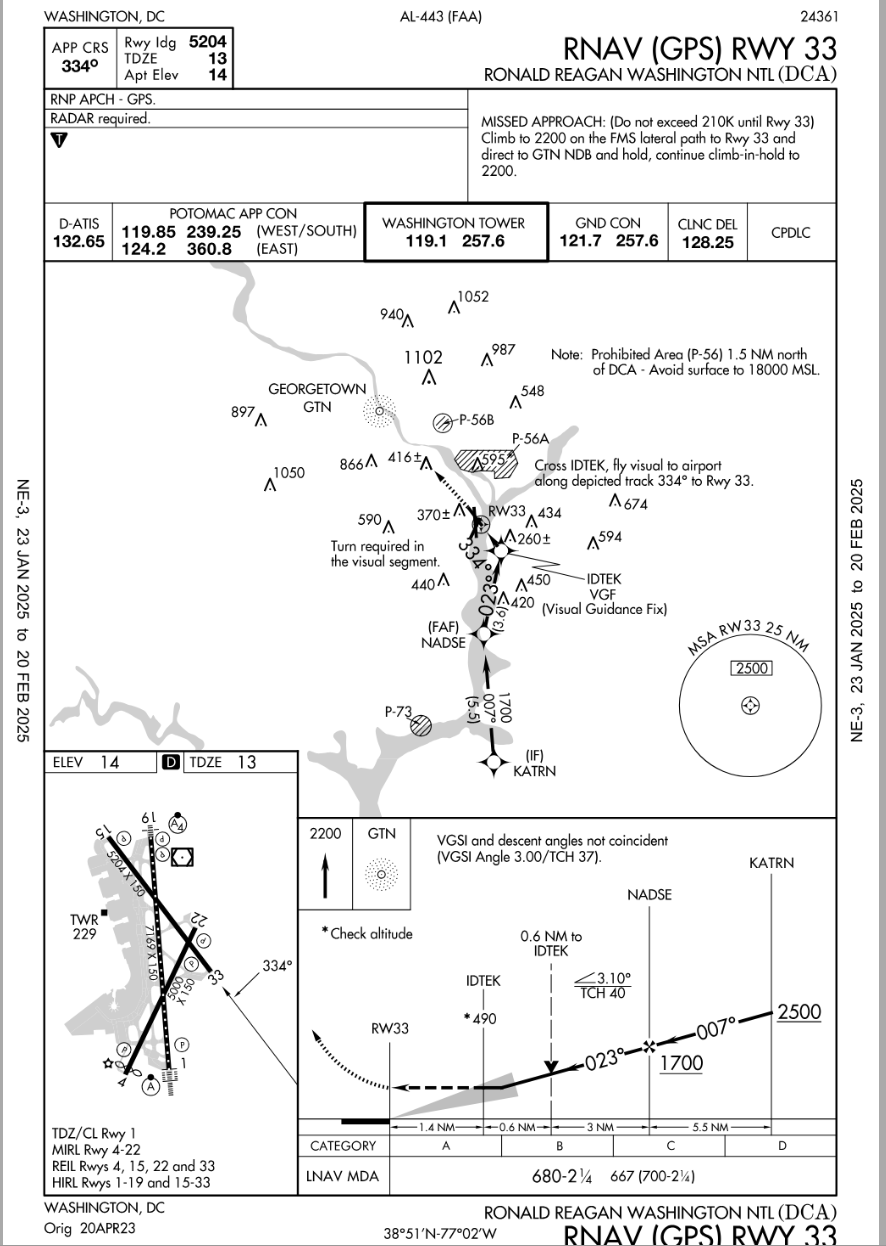
There is a curving RNAV approach, that is not in line with the runway until 490 feet/1.4nm, where one makes the last-minute ~50\xb0 left turn for visual runway alignment.
In light of that fact, maybe you can reframe your question.
AirNav: KDCA - Ronald Reagan Washington National Airport
https://aeronav.faa.gov/d-tpp/2501/00443R33.PDF
Now a test question for him.... . were you flying the incident airplane doing a Visual Approach to RWY33....would you have tuned up the IAP for that RWY as an additional reference for your approach ?
SOP's usually instruct Crews to use ILS data when doing Visual Approaches to runways with that kind of IAP so would that kind of thinking apply in this incident? Would that have been of any benefit considering the existing weather and terrain? Or, would that have been a distraction?
Pattern, perhaps you might review your comment.
It really is not a difficult concept or question.
Seems easy enough to understand if the post is actually read for comprehension sakes.
About 80% of all IATA operators would be discomforted by such changes, outside of the USA visual approaches at night have a litany of requirements to adhere to for the purposes of terrain separation, vs Texas big sky rules that do work in the US. In the end, taht didn't cause the accident, it is one of those things that goes with the freedom of flight in the USA.
...
Subjects
ATC
CRJ
KDCA
Separation (ALL)
Links are to this post in the relevant subject page so that this post can be seen in context.
Reply to this quoting this original post. You need to be logged in. Not available on closed threads.
February 01, 2025, 17:37:00 GMT
permalink Post: 11819189
I have only once flown into the Washington area, and it was more than a decade ago in a light single. I seem to recall DCA required special training even for airline pilots.
Is that not the case now or not for helicopter pilots? I thought it was a case where you need to be familiar to use those routes.
I fly in the DC FRZ and you hear the helo folks on freq all day, ( a lot of Coast Guard, various DoD, various fed LEO, some medivac and lifeguard) and they all know every inch of the area . Also surprising to listen to is that helo pilots through the FRZ are pretty much self-directed and entrusted with self sufficiency that fixed wing traffic is not . They've all been vetted, fingerprinted, have their own squawks etc and so ATC gives them a lot of respect. They announce intentions to 'fly route X' or 'request direct Andrews', and ATC is able to understand their intentions and clears a path and approves - and then you don't hear a peep from them until they reach the endpoint - then they announce next intention like "Field in sight'" -> "contact Andrews tower on..., Freq change approved" -> "good day" and the whole 20 minutes had a total of three radio calls. .
They seem to all know what they're doing and it's nobody's giving off the vibe that it's any kind of initial training for anything - you don't hear ATC having to telling them to 'say altitude' or 'turn left 10 degrees' or really anything, and you don't hear the pilots giving half arsed requests. [This level of trust might have had consequences, but I'll defer my judgement]
For all helo pilots local knowledge is a survival. Lots of civi helos in DC are based out of KFME, and the ones I know every inch of territory, every local landmark, overpass, bridge, body of water within the DC beltway like the back of their hand - one guy knows off the top of his head if every single road is asphalt or concrete, light or unlight, etc. Similar experience when I met news chopper folks based in the Valley - they knew hundreds of places in greater Los Angeles that I never even heard of.
Landmarks in DC are hard to miss, basically every one knows where the WW bridge, Hanes Point, the route of the Potomac, etc.. DCA is strangely popular for plane watching (there's rec areas to view at each end) so an absurdly large number of non-av people in the area are familiar with how the traffic flow works. I kayak right below the crash area and when wind is out of North, you can see landing lights of 7+ sequenced arrivals coming up the Potomac, it's basically impossible to miss the incoming landing parade and even non-av people get the concept. The WW bridge would seem to me a good point of reference for a callout, everybody knows where to immediately look. It's hard to think that the IP didn't understand local reference of the ATC traffic advisory.
Subjects
ATC
DCA
PAT25
Links are to this post in the relevant subject page so that this post can be seen in context.
Reply to this quoting this original post. You need to be logged in. Not available on closed threads.
February 01, 2025, 18:07:00 GMT
permalink Post: 11819203
My thoughts:
I continue to see this as:
- a failure of imagination by command;
- a system failure by command to monitor performance against expected system behaviour;
- an information system failure, the evidence has been in front of those that are charged with having safe systems such as the govt, regulator, DOD, airlines;
- The crew and the the ATC controller, and certainly the passengers are not high in the systemic failures that occur here, I would contend that the crew and the ATC officer are victims of the systemic failures.
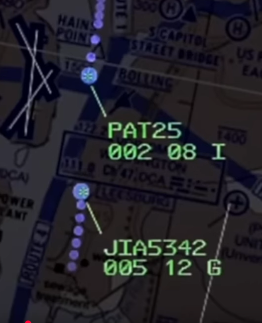
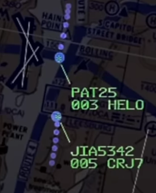
Criss-Crossing Routes in D.C. Airspace Leave Little Room for Error
By Elena Shao , Leanne Abraham , Eli Murray and Lazaro GamioThe pictures are out of order, the tracks are for "1-Week" of data. The latest NOTAM is a good start, the helo fleet operators may want to revisit the concept of the flyways.
A deadly midair collision between an American Airlines passenger jet and a U.S. Army helicopter near Ronald Reagan National Airport in Washington highlights the complexity of navigating an airspace with many civilian and military aircraft.
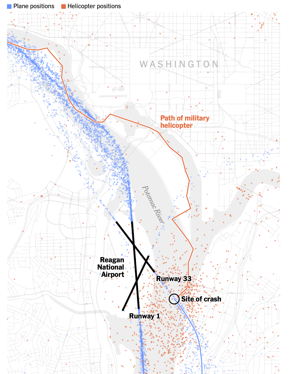
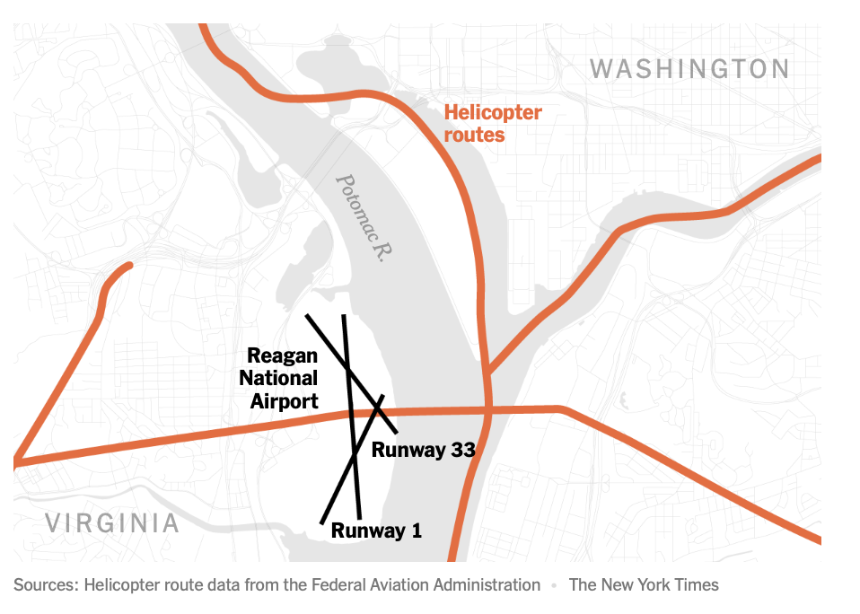
The airport has three runways that intersect, but only one is used for nearly all of its hundreds of daily flights. With the routes of aircraft routinely criss-crossing one another, there is little room for error as planes descend onto the runways. To stay out of the way of commercial jets, helicopters in this area are supposed to fly along a route designated by the Federal Aviation Administration at an altitude no higher than 200 feet.
Air traffic data from the past week shows that helicopters flying along the Potomac River must navigate amid the takeoffs and landings of hundreds of planes daily. While they are advised by the F.A.A. to stick to a tight air corridor above the eastern bank of the river, data shows that in reality, helicopters can be spotted across the width of the river.
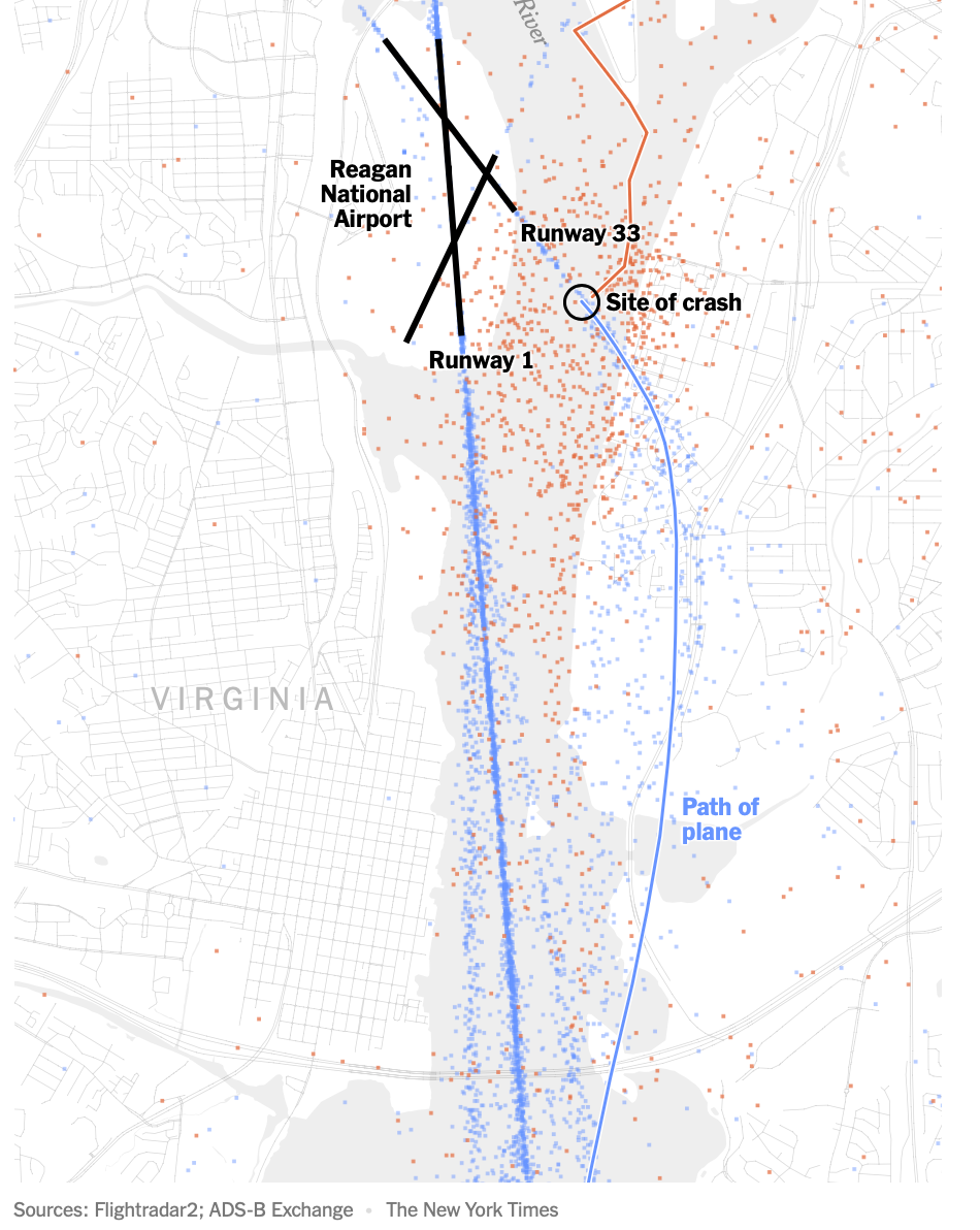
One week of air traffic at Reagan National
Dots show positions of planes during their takeoffs and landings at Reagan National Airport, as well as the positions of helicopters as they traversed the area from Jan. 23 to Jan. 30.The American Airlines flight was cleared to land on Runway 1 before being instructed by an air traffic controller shortly before the collision to pivot its landing route to the intersecting Runway 33.
The last-minute request to switch runways at Reagan National is “very common,” said Shawn Pruchnicki, a former airline pilot and an assistant professor at the Center for Aviation Studies at Ohio State University, who said he has piloted aircraft into the airport more than a hundred times.
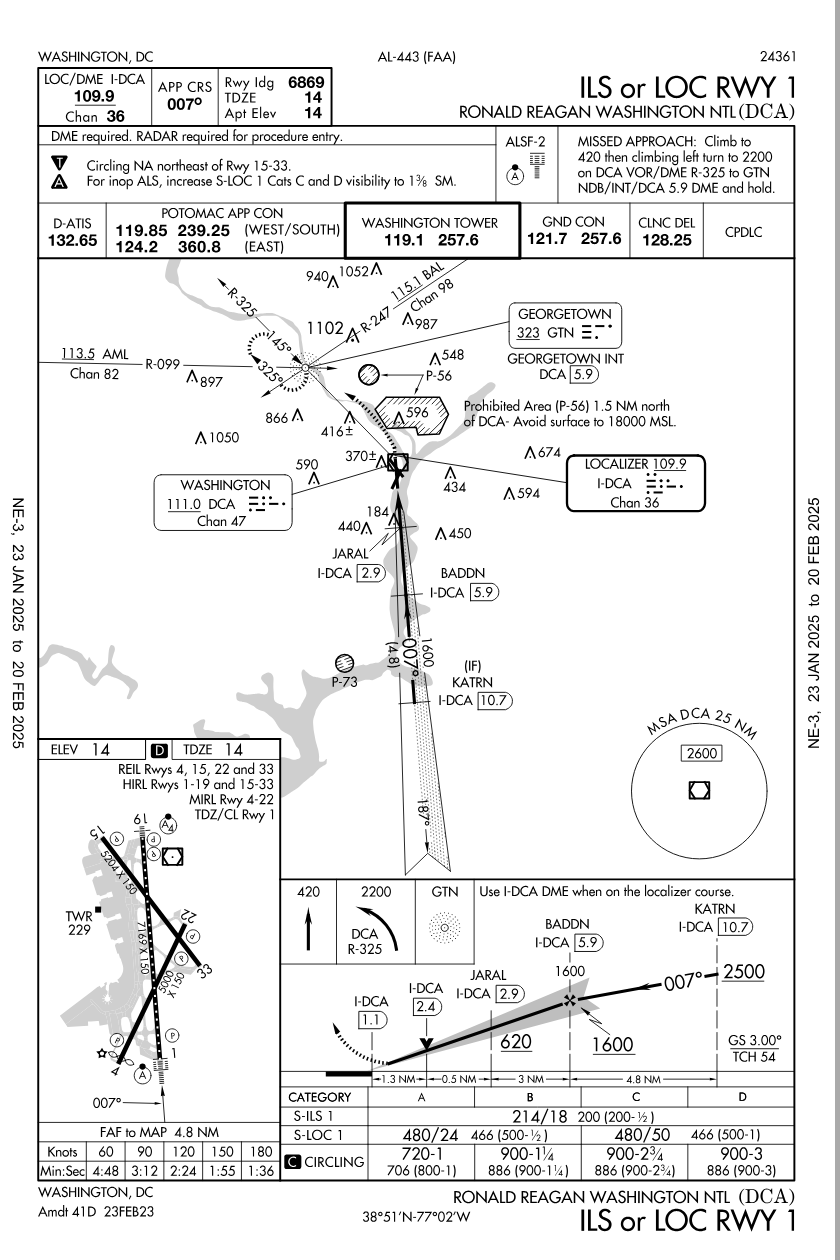
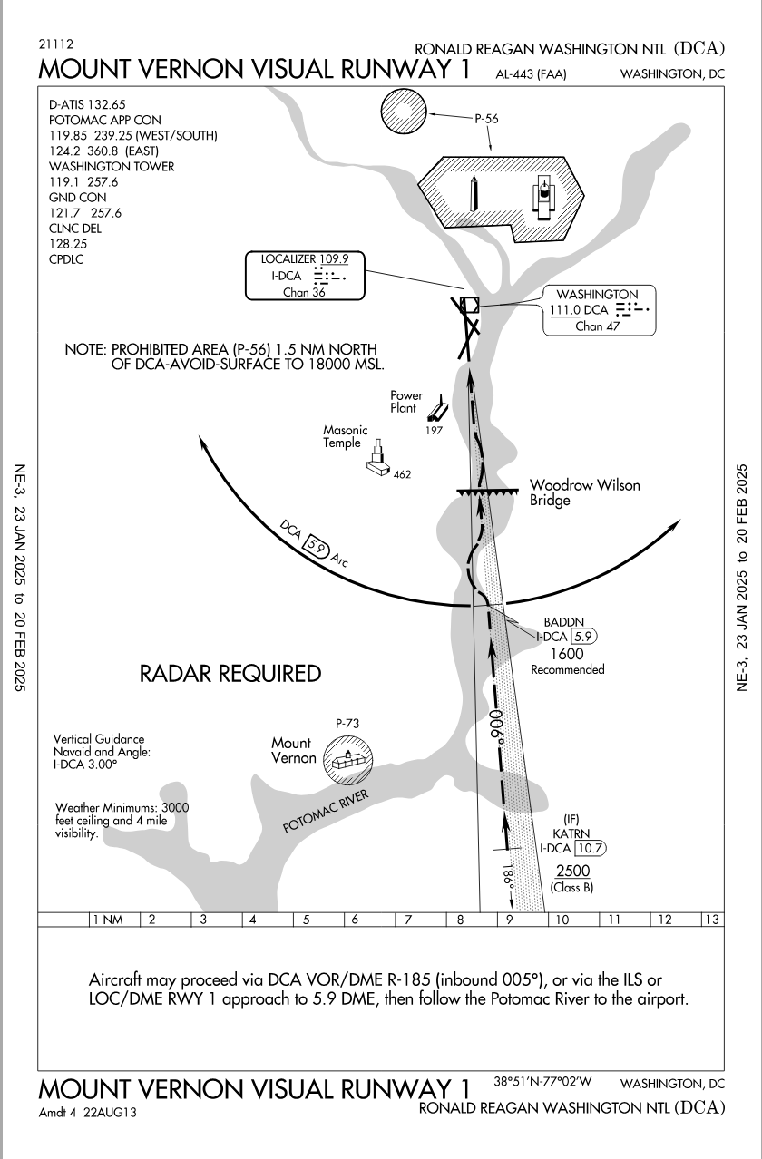
Skies were clear on Wednesday night when the two aircraft collided. But, in case of low visibility, like in poor weather, the F.A.A. has designed “instrument approaches,” or descents that involve a series of steps pilots must follow to maneuver down to the runway safely.
The instrument approach for Runway 1 calls for a descending plane to cross over the helicopter corridor while the plane is at a much higher altitude, somewhere from 620 to 1,700 feet and more than a minute from landing. The approach for Runway 33, however, calls for a plane to cross over the helicopter corridor at a much lower altitude, because a plane is seconds from landing. The clearance between a helicopter in the corridor and a descending plane may be from 100 to 300 feet, which can result in close calls if there are severe fluctuations in the altitude of either aircraft.
Sources: Helicopter route and instrument approach data from the Federal Aviation Administration
Note: An instrument approach is a descent that involves a series of scripted flight maneuvers, with pilots using navigation aids and instruments to reach the runway safely when visibility is low, such as in poor weather.
The [failing] New York Times
Given the clear nighttime weather, the plane’s pilots would not have been expected to initiate an instrument approach to aid their landing, Mr. Pruchnicki said, and instead could have used their vision to guide their descent to the runway. Data on the aircraft’s positions indicates that the pilots’ route was very similar to the one outlined in an instrument approach. For example, the plane maintained roughly the recommended altitude when it made a leftward turn toward Runway 33.
In this case, the Army Black Hawk requested permission to use the route designated for helicopters, meaning that it would keep to the eastern bank of the Potomac and stay under 200 feet in altitude. But the helicopter was at least a half-mile off of the approved route when it collided with the jet, according to four people briefed on the matter but not authorized to speak publicly. The helicopter was also flying above 300 feet, not below 200, the people said.
The crash also renewed questions about the safety of intersecting runways, which the F.A.A. has sought to eliminate or close in recent years in places like Chicago and Dallas because of concerns over congestion on the ground. The setup can increase the workload of the air traffic controller, especially if the two runways are getting used simultaneously for takeoff and landing, said Cyriel Kronenburg, a former air traffic controller and pilot.
An internal preliminary report from the F.A.A., which was reviewed by The New York Times , said that a supervisor allowed an air traffic controller to leave early, sometime before the crash. This left one air traffic controller to manage the dual roles of handling helicopters in the airport’s vicinity and also instructing planes that were landing and departing from runways, according to a person briefed on the matter. While it is within the supervisor’s discretion to combine the duties, that staffing configuration “was not normal for the time of day and volume of traffic,” the F.A.A. report said.
A Times investigation in 2023 found that the nation’s air traffic control facilities are chronically understaffed , contributing to an alarming number of close calls in the skies and on the runways across the country. Before the plane crash on Wednesday night, there were at least 10 close calls at Reagan National in the last three years that were documented in government records reviewed by The Times.
Additional research by Riley Mellen.
See more on: Federal Aviation Administration (F.A.A.)
https://www.nytimes.com/interactive/...smid=url-share
Subjects
ATC
Blackhawk (H-60)
Close Calls
FAA
Preliminary Report
Links are to this post in the relevant subject page so that this post can be seen in context.
Reply to this quoting this original post. You need to be logged in. Not available on closed threads.