February 01, 2025, 18:07:00 GMT
permalink Post: 11819203
My thoughts:
I continue to see this as:
- a failure of imagination by command;
- a system failure by command to monitor performance against expected system behaviour;
- an information system failure, the evidence has been in front of those that are charged with having safe systems such as the govt, regulator, DOD, airlines;
- The crew and the the ATC controller, and certainly the passengers are not high in the systemic failures that occur here, I would contend that the crew and the ATC officer are victims of the systemic failures.
Criss-Crossing Routes in D.C. Airspace Leave Little Room for Error
By Elena Shao , Leanne Abraham , Eli Murray and Lazaro GamioThe pictures are out of order, the tracks are for "1-Week" of data. The latest NOTAM is a good start, the helo fleet operators may want to revisit the concept of the flyways.
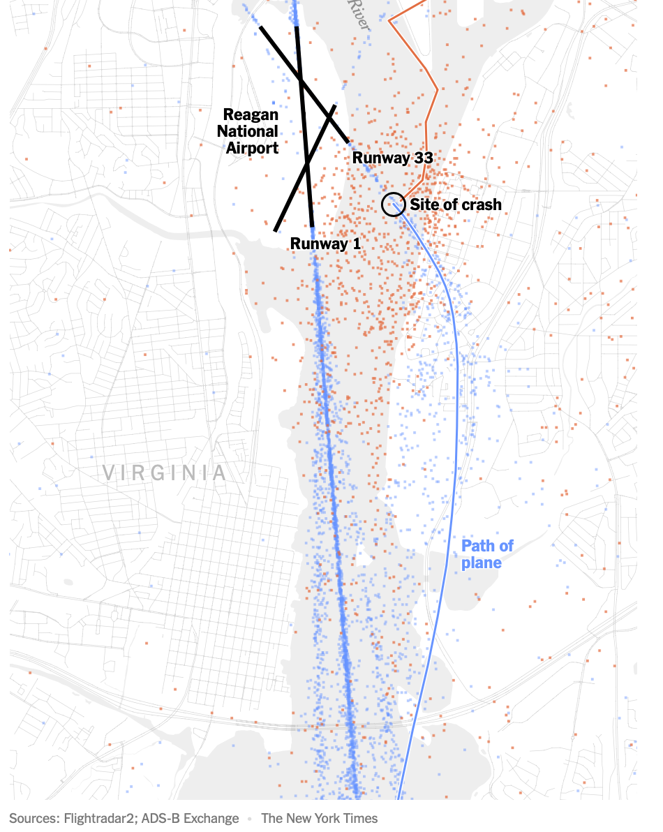
A deadly midair collision between an American Airlines passenger jet and a U.S. Army helicopter near Ronald Reagan National Airport in Washington highlights the complexity of navigating an airspace with many civilian and military aircraft.
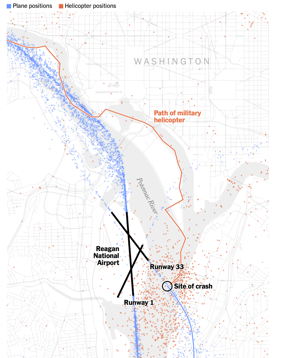
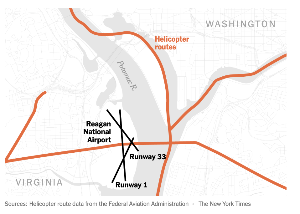
The airport has three runways that intersect, but only one is used for nearly all of its hundreds of daily flights. With the routes of aircraft routinely criss-crossing one another, there is little room for error as planes descend onto the runways. To stay out of the way of commercial jets, helicopters in this area are supposed to fly along a route designated by the Federal Aviation Administration at an altitude no higher than 200 feet.
Air traffic data from the past week shows that helicopters flying along the Potomac River must navigate amid the takeoffs and landings of hundreds of planes daily. While they are advised by the F.A.A. to stick to a tight air corridor above the eastern bank of the river, data shows that in reality, helicopters can be spotted across the width of the river.
One week of air traffic at Reagan National
Dots show positions of planes during their takeoffs and landings at Reagan National Airport, as well as the positions of helicopters as they traversed the area from Jan. 23 to Jan. 30.The American Airlines flight was cleared to land on Runway 1 before being instructed by an air traffic controller shortly before the collision to pivot its landing route to the intersecting Runway 33.
The last-minute request to switch runways at Reagan National is “very common,” said Shawn Pruchnicki, a former airline pilot and an assistant professor at the Center for Aviation Studies at Ohio State University, who said he has piloted aircraft into the airport more than a hundred times.
Skies were clear on Wednesday night when the two aircraft collided. But, in case of low visibility, like in poor weather, the F.A.A. has designed “instrument approaches,” or descents that involve a series of steps pilots must follow to maneuver down to the runway safely.
The instrument approach for Runway 1 calls for a descending plane to cross over the helicopter corridor while the plane is at a much higher altitude, somewhere from 620 to 1,700 feet and more than a minute from landing. The approach for Runway 33, however, calls for a plane to cross over the helicopter corridor at a much lower altitude, because a plane is seconds from landing. The clearance between a helicopter in the corridor and a descending plane may be from 100 to 300 feet, which can result in close calls if there are severe fluctuations in the altitude of either aircraft.
Sources: Helicopter route and instrument approach data from the Federal Aviation Administration
Note: An instrument approach is a descent that involves a series of scripted flight maneuvers, with pilots using navigation aids and instruments to reach the runway safely when visibility is low, such as in poor weather.
The [failing] New York Times
Given the clear nighttime weather, the plane’s pilots would not have been expected to initiate an instrument approach to aid their landing, Mr. Pruchnicki said, and instead could have used their vision to guide their descent to the runway. Data on the aircraft’s positions indicates that the pilots’ route was very similar to the one outlined in an instrument approach. For example, the plane maintained roughly the recommended altitude when it made a leftward turn toward Runway 33.
In this case, the Army Black Hawk requested permission to use the route designated for helicopters, meaning that it would keep to the eastern bank of the Potomac and stay under 200 feet in altitude. But the helicopter was at least a half-mile off of the approved route when it collided with the jet, according to four people briefed on the matter but not authorized to speak publicly. The helicopter was also flying above 300 feet, not below 200, the people said.
The crash also renewed questions about the safety of intersecting runways, which the F.A.A. has sought to eliminate or close in recent years in places like Chicago and Dallas because of concerns over congestion on the ground. The setup can increase the workload of the air traffic controller, especially if the two runways are getting used simultaneously for takeoff and landing, said Cyriel Kronenburg, a former air traffic controller and pilot.
An internal preliminary report from the F.A.A., which was reviewed by The New York Times , said that a supervisor allowed an air traffic controller to leave early, sometime before the crash. This left one air traffic controller to manage the dual roles of handling helicopters in the airport’s vicinity and also instructing planes that were landing and departing from runways, according to a person briefed on the matter. While it is within the supervisor’s discretion to combine the duties, that staffing configuration “was not normal for the time of day and volume of traffic,” the F.A.A. report said.
A Times investigation in 2023 found that the nation’s air traffic control facilities are chronically understaffed , contributing to an alarming number of close calls in the skies and on the runways across the country. Before the plane crash on Wednesday night, there were at least 10 close calls at Reagan National in the last three years that were documented in government records reviewed by The Times.
Additional research by Riley Mellen.
See more on: Federal Aviation Administration (F.A.A.)
https://www.nytimes.com/interactive/...smid=url-share
Subjects
ATC
Blackhawk (H-60)
Close Calls
FAA
Preliminary Report
Links are to this post in the relevant subject page so that this post can be seen in context.
Reply to this quoting this original post. You need to be logged in. Not available on closed threads.
February 02, 2025, 03:43:00 GMT
permalink Post: 11819495
Subjects
ATC
Altimeter (All)
Barometric Altimeter
Blackhawk (H-60)
CRJ
IFR
Links are to this post in the relevant subject page so that this post can be seen in context.
Reply to this quoting this original post. You need to be logged in. Not available on closed threads.
February 02, 2025, 04:12:00 GMT
permalink Post: 11819502
Subjects
Altimeter (All)
Barometric Altimeter
Blackhawk (H-60)
CRJ
Links are to this post in the relevant subject page so that this post can be seen in context.
Reply to this quoting this original post. You need to be logged in. Not available on closed threads.
February 02, 2025, 04:47:00 GMT
permalink Post: 11819512
The Blackhawk air data system would not be RVSM certified as it could not fly high enough to need it, but the CRJ definitely would be. The CRJ has independent dual digital air data computers, and I assume the Blackhawk does as well.
The \x9375 foot\x94 requirement does not come from a specific FAR, but from the Airman\x92s Information Manual (AIM), which states that if the current barometric pressure is set on the ground, that the altimeter should read within 75 feet of the known field elevation at the aircraft\x92s location or the \x93altimeter accuracy should be suspect\x94.
In the US, the altimeters of all civil aircraft that fly under IFR must be tested for required accuracy every 24 months. I assume military aircraft have to meet the same requirement.
FAR 43 Appendix \x91E\x92 is the basic standard for accuracy, but in the case of something like the CRJ, the AMM (Aircraft Maintenance Manual) Chapter 34 will have additional tests to perform which have much more stringent accuracy requirements set forth than FAR 43.
Last edited by JRBarrett; 2nd February 2025 at 04:59 .
Subjects
Altimeter (All)
Blackhawk (H-60)
CRJ
IFR
Links are to this post in the relevant subject page so that this post can be seen in context.
Reply to this quoting this original post. You need to be logged in. Not available on closed threads.
February 02, 2025, 06:15:00 GMT
permalink Post: 11819534
As a system ' - at night - I think it's crazy. But that's the system.
Subjects
ATC
Blackhawk (H-60)
Pass Behind
Pass Behind (All)
Separation (ALL)
Vertical Separation
Links are to this post in the relevant subject page so that this post can be seen in context.
Reply to this quoting this original post. You need to be logged in. Not available on closed threads.
February 02, 2025, 07:39:00 GMT
permalink Post: 11819561
As a system ' - at night - I think it's crazy. But that's the system.
Subjects
ATC
Blackhawk (H-60)
Pass Behind
Pass Behind (All)
Separation (ALL)
Vertical Separation
Links are to this post in the relevant subject page so that this post can be seen in context.
Reply to this quoting this original post. You need to be logged in. Not available on closed threads.
February 02, 2025, 08:00:00 GMT
permalink Post: 11819575
He is not a Blackhawk pilot, and has given quite inaccurate advice
Senior Pilot
Last edited by Senior Pilot; 2nd February 2025 at 20:46 . Reason: Add footnote
Subjects
Blackhawk (H-60)
Hover
Night Vision Goggles (NVG)
Links are to this post in the relevant subject page so that this post can be seen in context.
Reply to this quoting this original post. You need to be logged in. Not available on closed threads.
February 02, 2025, 13:52:00 GMT
permalink Post: 11819808
Subjects
ATC
Blackhawk (H-60)
CRJ
Links are to this post in the relevant subject page so that this post can be seen in context.
Reply to this quoting this original post. You need to be logged in. Not available on closed threads.
February 02, 2025, 15:04:00 GMT
permalink Post: 11819846
But from the beginning, various plots have shown the collision occurring in mid-river. A little work with Google Earth will show that the extended 33 centre line reaches mid-river about 3,300 feet from the aimpoint of runway 33. A 3 degree glideslope and some trig will put it at 175 feet at that range, with obvious implications. 375 feet would be a big error with not much more than half a mile left to run.
What am I doing wrong?
Also, helicopter route 4 hugs the eastern bank of the Potomac until Goose Island and doesn't cross to the western bank until Wilson Bridge. So why did the Black Hawk perform a 45 degree right turn while still abeam DCA? (See, e.g., post #25) Was it intending to route direct to Fort Belvoir, ignoring the heli routes? (I think I've seen it was operating out of Joint Base Anacostia en route to Fort Belvoir, so the fact it was still abeam DCA must have been more than obvious.)
Puzzled.
Last edited by DespairingTraveller; 2nd February 2025 at 15:24 . Reason: edited to correct typo
Subjects
Blackhawk (H-60)
CRJ
DCA
NTSB
Route 4
Links are to this post in the relevant subject page so that this post can be seen in context.
Reply to this quoting this original post. You need to be logged in. Not available on closed threads.
February 02, 2025, 16:21:00 GMT
permalink Post: 11819897
Subjects
ATC
Blackhawk (H-60)
Pass Behind
Pass Behind (All)
Separation (ALL)
Vertical Separation
Links are to this post in the relevant subject page so that this post can be seen in context.
Reply to this quoting this original post. You need to be logged in. Not available on closed threads.
February 02, 2025, 16:35:00 GMT
permalink Post: 11819905
But from the beginning, various plots have shown the collision occurring in mid-river. A little work with Google Earth will show that the extended 33 centre line reaches mid-river about 3,300 feet from the aimpoint of runway 33. A 3 degree glideslope and some trig will put it at 175 feet at that range, with obvious implications. 375 feet would be a big error with not much more than half a mile left to run.
What am I doing wrong?
Also, helicopter route 4 hugs the eastern bank of the Potomac until Goose Island and doesn't cross to the western bank until Wilson Bridge. So why did the Black Hawk perform a 45 degree right turn while still abeam DCA? (See, e.g., post #25) Was it intending to route direct to Fort Belvoir, ignoring the heli routes? (I think I've seen it was operating out of Joint Base Anacostia en route to Fort Belvoir, so the fact it was still abeam DCA must have been more than obvious.)
Puzzled.
Assuming the NTSB figure of 375ft is correct, you still need more info for it to mean anything. Was that the AGL, AMSL or SPS height/altitude?
How accurate are the 'various plots' that indicate the collision occurred mid-river? They may be right; they may not be.
Was the CRJ on final or was it still positioning to final? If it wasn't on final then the trigonometric calculations of what height it should be at might not be correct.
What official evidence is there that the Blackhawk made a 45 degree turn, or could that be a data error in the publicly available information?
In summary what I am saying is that, despite all of the internet sleuths plotting tracking data, none of it is official and it is all subject to various errors. Whilst interesting to form an understanding of the circumstances, it can't be assumed to be accurate to within a few feet (vertically or laterally).
All UH-60 A and L Army aircraft incorporated the APN 209 radar altimeter. Our Sikorsky tech fellow for Avioics/electronis reports the accuracy in this area is 1-2 feet. The radar altimeter position in the instrument panel is just to the right of the attitude indicator and its top matches the top of the attitude indicator. The barometric altimeter is immediately below it.
Both pilots have the same setup.
Subjects
ATC
Altimeter (All)
Barometric Altimeter
Blackhawk (H-60)
CRJ
DCA
NTSB
Radar
Radio Altimeter
Route 4
TCAS (All)
Links are to this post in the relevant subject page so that this post can be seen in context.
Reply to this quoting this original post. You need to be logged in. Not available on closed threads.
February 02, 2025, 16:51:00 GMT
permalink Post: 11819917
You can do pretty much anything in a helicopter, they also bite back "biggly" quicker than a heart beat, and there are a lot of UH-60's sitting in water where the crew were disoriented, SAS n' all.
An R-22 doing its stuff in the GAFA
A UH 60 doing its thang of a "quick" stop
A nice view of the Hathaway bridge just near the USN Panama City NSF, with a MH53 doing a turn from cruise, and a subsequent "quick" stop.
How on earth a helo driver is expected to do any hard maneuvering while maintaining visual contact with conflicting traffic is lost upon me, with or without NVG. Most of the time, a crew will do it and not have a problem, on other occasions the next day there are headlines of "Blackhawk crew lost in training mission over the ICW" etc.. Hope is not a plan, the crews deserve better and the passengers do as well.
Last edited by fdr; 2nd February 2025 at 21:53 . Reason: the 60 is vastly more capable than its predecessors. Thanks John for the info
Subjects
Blackhawk (H-60)
Hover
Night Vision Goggles (NVG)
Links are to this post in the relevant subject page so that this post can be seen in context.
Reply to this quoting this original post. You need to be logged in. Not available on closed threads.
February 02, 2025, 16:54:00 GMT
permalink Post: 11819920
What you are doing wrong is making guesses based on incomplete/inaccurate data that is in the public domain.
Assuming the NTSB figure of 375ft is correct, you still need more info for it to mean anything. Was that the AGL, AMSL or SPS height/altitude?
How accurate are the 'various plots' that indicate the collision occurred mid-river? They may be right; they may not be.
Was the CRJ on final or was it still positioning to final? If it wasn't on final then the trigonometric calculations of what height it should be at might not be correct.
What official evidence is there that the Blackhawk made a 45 degree turn, or could that be a data error in the publicly available information?
In summary what I am saying is that, despite all of the internet sleuths plotting tracking data, none of it is official and it is all subject to various errors. Whilst interesting to form an understanding of the circumstances, it can't be assumed to be accurate to within a few feet (vertically or laterally).
That 1-2 feet error would be a theoretical accuracy. The readout in the cockpit would be subject to significant errors during turns/pitch changes etc; without knowing the exact installation on a Blackhawk, it might also unlock based on the surface conditions. More importantly, the ATC instructions would probably be based on an altimeter setting and not Rad Alt.
How would that have worked in this scenario? Who do you think should have been directed by TCAS to do what? Does the Blackhawk even have TCAS?
Subjects
ATC
Altimeter (All)
Blackhawk (H-60)
CRJ
NTSB
Radio Altimeter
TCAS (All)
TCAS RA
Links are to this post in the relevant subject page so that this post can be seen in context.
Reply to this quoting this original post. You need to be logged in. Not available on closed threads.
February 02, 2025, 17:02:00 GMT
permalink Post: 11819928
(My credentials for that viewpoint - 16,000+ hours, inc 10,000+ heavy helicopter and 6,000+ light and medium fixed wing).
Last edited by Ant T; 2nd February 2025 at 19:25 . Reason: bold added for emphasis by Moderator and adding my credentials
Subjects
Blackhawk (H-60)
Hover
Links are to this post in the relevant subject page so that this post can be seen in context.
Reply to this quoting this original post. You need to be logged in. Not available on closed threads.
February 02, 2025, 17:19:00 GMT
permalink Post: 11819940
What you are doing wrong is making guesses based on incomplete/inaccurate data that is in the public domain.
Assuming the NTSB figure of 375ft is correct, you still need more info for it to mean anything. Was that the AGL, AMSL or SPS height/altitude?
How accurate are the 'various plots' that indicate the collision occurred mid-river? They may be right; they may not be.
Was the CRJ on final or was it still positioning to final? If it wasn't on final then the trigonometric calculations of what height it should be at might not be correct.
What official evidence is there that the Blackhawk made a 45 degree turn, or could that be a data error in the publicly available information?
In summary what I am saying is that, despite all of the internet sleuths plotting tracking data, none of it is official and it is all subject to various errors. Whilst interesting to form an understanding of the circumstances, it can't be assumed to be accurate to within a few feet (vertically or laterally).
Similarly, given that both aircraft did sadly end up in the river, there's limited margin for error in the position of the impact as well. The Potomac is narrow near DCA as a glance at a chart will show.
Anyway, I have no expectation of solving anything. Just trying to understand the information that's out there.
Subjects
Blackhawk (H-60)
CRJ
DCA
NTSB
Links are to this post in the relevant subject page so that this post can be seen in context.
Reply to this quoting this original post. You need to be logged in. Not available on closed threads.
February 02, 2025, 18:20:00 GMT
permalink Post: 11819978
In relation to your earlier response to my previous comment, how can the system tell someone to 'remain level' when that aircraft doesn't have TCAS? I am not sure of the Blackhawk fit, but I would be pretty surprised if it has TCAS fitted.
One of the main reasons that TCAS alerts are inhibited at low altitude is to avoid distraction during the landing phase, in an area that has a high traffic density and a high probably of nuisance alerts. The system would constantly be giving RAs and people would be going around and deviating all over the place. Even if just TAs were left active then it would be going off all the time, and we would be having the same conversation about becoming blase to the warnings as we are about the repetitive conflict alerts that were being given to the LC.
Getting TCAS to give RAs on final is not the solution in my opinion.
Subjects
Blackhawk (H-60)
TCAS (All)
TCAS RA
Links are to this post in the relevant subject page so that this post can be seen in context.
Reply to this quoting this original post. You need to be logged in. Not available on closed threads.
February 02, 2025, 18:46:00 GMT
permalink Post: 11819999
In relation to your earlier response to my previous comment, how can the system tell someone to 'remain level' when that aircraft doesn't have TCAS? I am not sure of the Blackhawk fit, but I would be pretty surprised if it has TCAS fitted.
One of the main reasons that TCAS alerts are inhibited at low altitude is to avoid distraction during the landing phase, in an area that has a high traffic density and a high probably of nuisance alerts. The system would constantly be giving RAs and people would be going around and deviating all over the place. Even if just TAs were left active then it would be going off all the time, and we would be having the same conversation about becoming blase to the warnings as we are about the repetitive conflict alerts that were being given to the LC.
Getting TCAS to give RAs on final is not the solution in my opinion.
Subjects
ADSB (All)
Blackhawk (H-60)
TCAS (All)
TCAS RA
Links are to this post in the relevant subject page so that this post can be seen in context.
Reply to this quoting this original post. You need to be logged in. Not available on closed threads.
February 02, 2025, 19:00:00 GMT
permalink Post: 11820010
In relation to your earlier response to my previous comment, how can the system tell someone to 'remain level' when that aircraft doesn't have TCAS? I am not sure of the Blackhawk fit, but I would be pretty surprised if it has TCAS fitted.
One of the main reasons that TCAS alerts are inhibited at low altitude is to avoid distraction during the landing phase, in an area that has a high traffic density and a high probably of nuisance alerts. The system would constantly be giving RAs and people would be going around and deviating all over the place. Even if just TAs were left active then it would be going off all the time, and we would be having the same conversation about becoming blase to the warnings as we are about the repetitive conflict alerts that were being given to the LC.
Getting TCAS to give RAs on final is not the solution in my opinion.
And inhibition floor could still be greater than zero - say 100-200ft?
Separately, is it correct to say that CRJ were on final, or were they perhaps still turning onto final?
Subjects
Blackhawk (H-60)
CRJ
TCAS (All)
TCAS RA
Links are to this post in the relevant subject page so that this post can be seen in context.
Reply to this quoting this original post. You need to be logged in. Not available on closed threads.
February 02, 2025, 19:02:00 GMT
permalink Post: 11820013
In relation to your earlier response to my previous comment, how can the system tell someone to 'remain level' when that aircraft doesn't have TCAS? I am not sure of the Blackhawk fit, but I would be pretty surprised if it has TCAS fitted.
One of the main reasons that TCAS alerts are inhibited at low altitude is to avoid distraction during the landing phase, in an area that has a high traffic density and a high probably of nuisance alerts. The system would constantly be giving RAs and people would be going around and deviating all over the place. Even if just TAs were left active then it would be going off all the time, and we would be having the same conversation about becoming blase to the warnings as we are about the repetitive conflict alerts that were being given to the LC. a
Getting TCAS to give RAs on final is not the solution in my opinion.
Nuisance go-arounds caused by RAs don't seem like a high price to pay to avoid this kind of catastrophic event. And perhaps nuisance go-arounds might cause some re-considerations of poor airspace design, such as this appears to be.
Subjects
ADSB (All)
Blackhawk (H-60)
TCAS (All)
TCAS RA
Links are to this post in the relevant subject page so that this post can be seen in context.
Reply to this quoting this original post. You need to be logged in. Not available on closed threads.
February 02, 2025, 19:26:00 GMT
permalink Post: 11820029
In relation to your earlier response to my previous comment, how can the system tell someone to 'remain level' when that aircraft doesn't have TCAS? I am not sure of the Blackhawk fit, but I would be pretty surprised if it has TCAS fitted.
One of the main reasons that TCAS alerts are inhibited at low altitude is to avoid distraction during the landing phase, in an area that has a high traffic density and a high probably of nuisance alerts. The system would constantly be giving RAs and people would be going around and deviating all over the place. Even if just TAs were left active then it would be going off all the time, and we would be having the same conversation about becoming blase to the warnings as we are about the repetitive conflict alerts that were being given to the LC.
Getting TCAS to give RAs on final is not the solution in my opinion.
Fairly confident (and reported earlier) that the Blackhawk only has Mode S, so no ADS-B. Mode S may report less than ADS-B which means that position updates can be (but not always) significantly slower than ADS-B out. I also believe that for RA to work both aircraft would need to have both ADS-B In and ADS-B Out so that 2 way data communication can take place.
Subjects
ADSB (All)
ADSB In
ADSB Out
Blackhawk (H-60)
TCAS (All)
TCAS RA
Links are to this post in the relevant subject page so that this post can be seen in context.
Reply to this quoting this original post. You need to be logged in. Not available on closed threads.