February 15, 2025, 10:24:00 GMT
permalink Post: 11828489
I sincerely hope the NTSB can avoid being distracted by the distractions of altimetry and the missing ATC words on the Blackhawk CVR.
Upthread, Luca Lion calculated the 3 degree PAPI approach path as crossing the eastern riverbank at 270ft. If that's correct, then the CRJ's 313ft radar height 2 seconds before collision puts it at least 43ft above the approach path, so the Blackhawk's radio height deviation of 78ft would have contributed only about 35ft to the erosion of any intended "procedural separation" (*) between the aircraft. Or, to put it another way, the same outcome would have resulted if the Blackhawk had been at 235ft radio and the CRJ on the glide. Height keeping of plus or minus 35ft can only be achieved by instrument flying, which is obviously not compatible with visual separation (or indeed VFR) so cannot be reasonably cited as part of a safety case for the procedure. And of course a landing aircraft could easily be below the glide. Altimetry and height keeping are not the cause of this accident.
Missing the word "circling" wouldn't have influenced the helo crew getting visual with the CRJ at the time of the trasnmission. At best, it would have given them an extra nudge that "runway 33" (which was audible) meant the CRJ would be taking an easterly flight path. Missing "pass behind" with only a few seconds to collision was irrelevant if, as seems likely, the helo crew did not see the CRJ at that point.
(*) The quotes around "procedural separation" are intended to convey a tone of disgust and sarcasm.
Last edited by Easy Street; 15th February 2025 at 10:47 .
Subjects
ATC
Altimeter (All)
Blackhawk (H-60)
CRJ
CVR
Final Report
NTSB
Pass Behind
Pass Behind (All)
Radar
Separation (ALL)
VFR
Visual Separation
Links are to this post in the relevant subject page so that this post can be seen in context.
Reply to this quoting this original post. You need to be logged in. Not available on closed threads.
February 15, 2025, 10:55:00 GMT
permalink Post: 11828510
I sincerely hope the NTSB can avoid being distracted by the distractions of altimetry and the missing ATC words on the Blackhawk CVR.
Upthread, Luca Lion calculated the 3 degree PAPI approach path as crossing the eastern riverbank at 270ft. If that's correct, then the CRJ's 313ft radar height 2 seconds before collision puts it at least 43ft above the approach path, so the Blackhawk's radio height deviation of 78ft would have contributed only about 35ft to the erosion of any intended "procedural separation" (*) between the aircraft. Or, to put it another way, the same outcome would have resulted if the Blackhawk had been at 235ft radio and the CRJ on the glide. Height keeping of plus or minus 35ft can only be achieved by instrument flying, which is obviously not compatible with visual separation (or indeed VFR) so cannot be reasonably cited as part of a safety case for the procedure. And of course a landing aircraft could easily be below the glide. Altimetry and height keeping are not the cause of this accident.
Missing the word "circling" wouldn't have influenced the helo crew getting visual with the CRJ at the time of the trasnmission. At best, it would have given them an extra nudge that "runway 33" (which was audible) meant the CRJ would be taking an easterly flight path. Missing "pass behind" with only a few seconds to collision was irrelevant if, as seems likely, the helo crew did not see the CRJ at that point.
(*) The quotes around "procedural separation" are intended to convey a tone of disgust and sarcasm.
Following "5*why", keep asking...
Why did the did miss part of the message
Why was the incomplete read back missed
Why does missing a few words lead to this disaster within seconds.
Does this lead an answer like: helicopter in a very busy airspace, busy controllers (insufficient time to be fully focused on full read backs) being by default too close to (and even needing to cross) the glideslope.
Subjects
ATC
Blackhawk (H-60)
CRJ
CVR
NTSB
Pass Behind
Pass Behind (All)
Radar
Separation (ALL)
VFR
Visual Separation
Links are to this post in the relevant subject page so that this post can be seen in context.
Reply to this quoting this original post. You need to be logged in. Not available on closed threads.
February 16, 2025, 04:46:00 GMT
permalink Post: 11828977
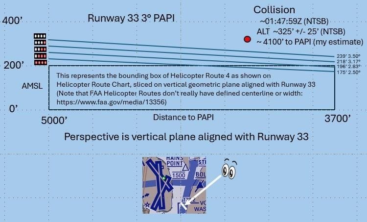
• At 8:47:58, or 1 second before impact, the CRJ began to increase its pitch, reaching about 9 degrees nose up at the time of collision. FDR data showed the CRJ elevators were deflected near their maximum nose up travel .
• The last radio altitude recorded for the CRJ was 313 ft and was recorded two seconds prior to the collision. The CRJ pitch at this time was, again, 9 degrees nose up, and roll was 11 degrees left wing down. The CRJ was descending at 448 feet per minute.
• The radio altitude of the Blackhawk at the time of the collision was 278 feet and had been steady for the previous 5 seconds. The Blackhawk pitch at the time of the collision was about a half degree nose up with a left roll of 1.6 degrees. Examination of wreckage will assist in determination of the exact angle of the collision.
I was once stopped at a red light, began rolling when the light turned green - and suddenly found myself on the brakes before I was conscious of the car running the red light. Possibly a CRJ pilot similarly caught the helo in peripheral vision and reacted subconsciously.
Last edited by RatherBeFlying; 16th February 2025 at 04:50 . Reason: Formatting
Subjects
Blackhawk (H-60)
CRJ
CVR
DCA
NTSB
Links are to this post in the relevant subject page so that this post can be seen in context.
Reply to this quoting this original post. You need to be logged in. Not available on closed threads.
February 16, 2025, 08:38:00 GMT
permalink Post: 11829051
I was once stopped at a red light, began rolling when the light turned green - and suddenly found myself on the brakes before I was conscious of the car running the red light. Possibly a CRJ pilot similarly caught the helo in peripheral vision and reacted subconsciously.
Subjects
CRJ
CVR
NTSB
Links are to this post in the relevant subject page so that this post can be seen in context.
Reply to this quoting this original post. You need to be logged in. Not available on closed threads.
February 16, 2025, 18:30:00 GMT
permalink Post: 11829380
200 feet is the maximum and they had to get permission for this route. They\x92re flying past a busy airport. On one hand you\x92re all saying this accident was bound to happen, on the other hand this in and of itself indicates pilots don\x92t fly through these zones without concerns & vigilance. It makes no sense they would play roulette with the height - most pilots would be adhering to rules & a little on edge knowing a VIP or any number of emergency protocols could happen in the capital of America.
It just doesn\x92t add up - the complacency over elevation. Between two pilots it should have been rectified. May they rest in peace & this isn\x92t a slur against their name but in support of it not being their fault and something amiss.
Systems that rely on human perfection are 100% guaranteed to fail. The only question is how often. The system in place at DCA required helo pilots to assume responsibility for visual (*not vertical*) avoidance of collisions in order to fulfil their ordered missions. Given what we know about human visual performance at night, that would eventually end badly, and sure enough it did. There is a strong element of the pilots having been set up to fail, which is why no-one here is going hard on them.
Altimetry and height keeping would be important matters for investigators if the collision had occurred due to a breakdown in vertical separation, which as a minimum would involve 500 feet (and more often 1000 feet) of planned spacing to account for instrument and height keeping errors. FAA instrument rating standards require pilots to be able to maintain altitude plus or minus 100 feet. This helicopter was being flown VFR at very low height, which means that looking outside takes primacy over monitoring instruments. I'm sure helo pilots could fly along at 175ft plus or minus 25ft if they really tried, but you can be certain they wouldn't be looking out for traffic (as is required when holding responsibility for visual separation).
However, as there was no vertical separation built into this procedure, all of this is at best a distraction. The more important questions are why procedural barriers were not in place to stop the route being used during landings on runway 33, and whether visual separation at night is an adequate barrier to collision when airliners and their human cargo are involved.
Last edited by Easy Street; 16th February 2025 at 18:57 .
Subjects
CRJ
DCA
FAA
PAT25
Separation (ALL)
VFR
Vertical Separation
Visual Separation
Links are to this post in the relevant subject page so that this post can be seen in context.
Reply to this quoting this original post. You need to be logged in. Not available on closed threads.
February 16, 2025, 18:49:00 GMT
permalink Post: 11829389
Altimetry and height keeping would be important matters for investigators if the collision had occurred due to a breakdown in vertical separation, which as a minimum would involve 500 feet (and more often 1000 feet) of planned spacing to account for instrument and height keeping errors. FAA instrument rating standards require pilots to be able to maintain altitude plus or minus 100 feet. This helicopter was being flown VFR at very low height, which means that looking outside takes primacy over monitoring instruments. I'm sure helo pilots could fly along at 175ft plus or minus 25ft if they really tried, but you can be certain they wouldn't be looking out for traffic (as required when taking visual separation).
However, as there was no vertical separation built into this procedure, all of this is at best a distraction. The more important questions are why procedural barriers were not in place to stop the route being used during landings on runway 33, and whether visual separation at night is an adequate barrier to collision when airliners and their human cargo are involved.
N123, do you see the closest plane lined up, pass right below and behind him and never mind all the other planes right behind. Ah......NO.
There is night visual and there is night nutty visual. The first example leaves a lot of room for error and time for ATC to see if it is going wrong.
Subjects
ATC
CRJ
FAA
PAT25
Pass Behind
Pass Behind (All)
Separation (ALL)
VFR
Vertical Separation
Visual Separation
Links are to this post in the relevant subject page so that this post can be seen in context.
Reply to this quoting this original post. You need to be logged in. Not available on closed threads.
February 16, 2025, 22:53:00 GMT
permalink Post: 11829514
Subjects
ATC
CRJ
Night Vision Goggles (NVG)
Pass Behind
Pass Behind (All)
Separation (ALL)
Links are to this post in the relevant subject page so that this post can be seen in context.
Reply to this quoting this original post. You need to be logged in. Not available on closed threads.
February 16, 2025, 23:09:00 GMT
permalink Post: 11829529
He doesn't know his mental model is dead wrong because he latched onto the wrong aircraft in the cluster of 4 visible when the traffic was called to him a couple of minutes ago.
Last edited by Easy Street; 16th February 2025 at 23:38 .
Subjects
CRJ
Night Vision Goggles (NVG)
Links are to this post in the relevant subject page so that this post can be seen in context.
Reply to this quoting this original post. You need to be logged in. Not available on closed threads.
February 17, 2025, 01:03:00 GMT
permalink Post: 11829565
TCAS
ATC
ADS-B
See and Avoid
Filing a flight plan
Not operating in controlled airspace without a transponder
Not operating at a landing altitude for aircraft on final for a well used runway
Announcing an intention to cross a well used approach
Position lights/strobes
Landing lights
Just spitballing, but there's a non-zero chance NVGs were in use in the helicopter.
It sucks that the best part of this is the airplane was a CRJ, not a larger airliner. Most all those passengers would have survived the initial collision and been aware during the fall to the river.
I feel rage.
So the message for everyone is to politely and firmly refuse to do things that are not in your own interest, to make copious reports through safety management systems of events that you see that breach the normal, and to stop trying to work around a broken system where you ultimately will be the scapegoat.
Last edited by Wide Mouth Frog; 17th February 2025 at 01:37 .
Subjects
ADSB (All)
ATC
CRJ
Night Vision Goggles (NVG)
See and Avoid
TCAS (All)
Links are to this post in the relevant subject page so that this post can be seen in context.
Reply to this quoting this original post. You need to be logged in. Not available on closed threads.
February 17, 2025, 01:08:00 GMT
permalink Post: 11829568
Your litany of how the holes in the cheese lined up might be missing a detail or two, but any of those holes not lining up might have avoided this tragedy.
The rad alt is right there.
At night over water at low level, the pilots I flew with did not ignore their rad alt.
It was a part of one's scan.
If I know that field elevation is 14', and my rad alt isn't at 200' or less on a route where max altitude is 200', a correction is needed now, before the error gets larger. (The separate issue of going behind, and that tower guidance apparently being stepped on, is another pair of holes in the cheese).
I am at a loss to understand the apparent magnitude of the altitude error (they were still too close laterally, yes), but as I've been out of the cockpit for a few years I am not aware of what's being taught these days.
On most airlines, they do have a barf bag, still, in the seat pocket in front of you. Suggest you vomit into that and avoid the choke hazard.
Subjects
ATC
CRJ
Night Vision Goggles (NVG)
Pass Behind
Pass Behind (All)
Radio Altimeter
Separation (ALL)
Links are to this post in the relevant subject page so that this post can be seen in context.
Reply to this quoting this original post. You need to be logged in. Not available on closed threads.
February 17, 2025, 03:42:00 GMT
permalink Post: 11829612
While the PAT 25 pilots, prior to take off, would set the barometric pressure each gauge must have no more than a +/- 75 foot error (FAA). One gauge may have read + 50 feet high while the other one read - 50 feet low which would account for the 100 foot difference in flight between the two barometric altimeters. Many mechanical and pilot input errors would be potential factors. Not common but sometimes a pilot will read back the correct setting while at the same time setting a different value by mistake. IF the 100 foot discrepancy was discussed initially on the ground it may account for the lack of discussion , later in the flight, while at 400 feet PM and 300 feet PF. It begs the question was radar altimeter planned to be used and if so when?
Even though there are some transmissions stepped on for various reasons, the words runway thirty three were mentioned a number of times. As crossing the threshold to runway 33 posed a significant risk to PAT 25 I would have thought the PAT 25 crew, to know from experience, that in 3 to 4 minutes from the time ATC reported the CRJ crossing the bridge the CRJ would pass directly in front of them at or near the same altitude. It's not clear to me why PAT 25 would not have reduced airspeed and or held at HAINS point.
I belive the simultaneous helicopter and runway 33 operations should never have been permitted. Clearance limits and expected further clearance times mirroring the ETA for rwy 33 given to helicopters to arrive at or hold at HAINS point would have be helpful in preventing conflicts.
Subjects
ATC
Altimeter (All)
CRJ
FAA
Night Vision Goggles (NVG)
Radar
Links are to this post in the relevant subject page so that this post can be seen in context.
Reply to this quoting this original post. You need to be logged in. Not available on closed threads.
February 17, 2025, 06:24:00 GMT
permalink Post: 11829650
You could reasonably define the bank as the water's edge, and therefore expect crews to fly along an infinitesimally narrow path. Or as the space between the water's edge and the [edge of the flood plain | first flat area | something else], which would imply that the western boundary changes with the water level. Both imply the route is substantially above land.
Neither are useful for precise navigation, but the map and the description are probably 'close enough' if they are only needed for general route guidance and knowing that structures on the east bank need to be NOTAMed for helicopters, but probably not the west bank.
A good reminder that measurements/specifications without tolerance are often worse than useless.
If it quacks like a duck... this kind of "It can't be an X because we can't do it, so we'll call it a Y" leads to a culture that gets used to massaging the truth for convenience. Did we hear more on the Alaska door plug that was an 'opening' not a 'removal'?
Subjects
ATC
CRJ
DCA
FAA
KDCA
NTSB
Night Vision Goggles (NVG)
Pass Behind
Pass Behind (All)
Separation (ALL)
Links are to this post in the relevant subject page so that this post can be seen in context.
Reply to this quoting this original post. You need to be logged in. Not available on closed threads.
February 17, 2025, 12:54:00 GMT
permalink Post: 11829882
If everyone had been flying at the prescribed altitudes, the CRJ should have passed 40ft over the Blackhawk, I can't believe that would have been OK.
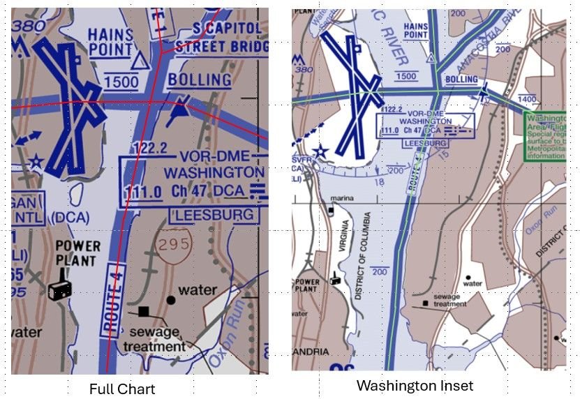
I was very surprised also to hear Jennifer tell us that the heliroutes have no lateral boundaries, which is a bit bizarre given that the Route 4 in the notes on the chart is described as following the East bank of the Potomac which is about on the left end of the diagram. Doesn't matter though, same problem there. Routes shouldn't be designed so that aircraft can infringe on landing (or any other kind) of passenger jet traffic.
Subjects
Blackhawk (H-60)
CRJ
Route 4
Links are to this post in the relevant subject page so that this post can be seen in context.
Reply to this quoting this original post. You need to be logged in. Not available on closed threads.
February 17, 2025, 13:29:00 GMT
permalink Post: 11829899
Subjects
CRJ
Links are to this post in the relevant subject page so that this post can be seen in context.
Reply to this quoting this original post. You need to be logged in. Not available on closed threads.
February 17, 2025, 22:45:00 GMT
permalink Post: 11830289
Subjects
Blackhawk (H-60)
CRJ
Links are to this post in the relevant subject page so that this post can be seen in context.
Reply to this quoting this original post. You need to be logged in. Not available on closed threads.
February 17, 2025, 22:56:00 GMT
permalink Post: 11830297
Subjects
Blackhawk (H-60)
CRJ
Links are to this post in the relevant subject page so that this post can be seen in context.
Reply to this quoting this original post. You need to be logged in. Not available on closed threads.
February 18, 2025, 01:04:00 GMT
permalink Post: 11830382
Subjects
Blackhawk (H-60)
CRJ
FAA
Links are to this post in the relevant subject page so that this post can be seen in context.
Reply to this quoting this original post. You need to be logged in. Not available on closed threads.
February 18, 2025, 08:00:00 GMT
permalink Post: 11830516
I wouldn't put it past the FAA to pull a stunt like that, read Mary Schiavo's (ex IG of the Dept. of Transportation) book if you want to know how wily they can be. And Jennifer gave them the perfect lay up in the last briefing.
It's way to easy to blame the pilots, over the years there have been incidents due to incorrect QNH settings, were both pilots and ATC have failed to catch the error, in a busy airspace with overworked ATC, late change of runway for airlines, and military helicopters using Night Vision Goggles, altimeter equipment failure/error.
Even the Max 200 ft altitude under the approach to a major US airport is an accident waiting to happen, and whoever approved this to be used during normal operations should be investigated. The CRJ was at around 325 ft on a visual/circling approach when it crashed, does anyone really think it's great airmanship to have a Black Hawk helicopter at 200 ft passing under you?
That's what made the Swiss Cheese model line up perfectly, a planned approved separation of 125 ft was the "best case" scenario.
Subjects
ATC
Accident Waiting to Happen
Altimeter (All)
Blackhawk (H-60)
CRJ
FAA
QNH
Separation (ALL)
Links are to this post in the relevant subject page so that this post can be seen in context.
Reply to this quoting this original post. You need to be logged in. Not available on closed threads.
February 19, 2025, 23:16:00 GMT
permalink Post: 11831829
Added note: The chart shows only crossings collected with ADS-B. I threw out all MLAT collected crossing because of inherent inaccuracy.
Helicopters crossing RWY 33 approach via Route 4 for January
Interesting to note that, had PAT25 been at 200 ft and the CRJ just slightly below nominal glideslope, they would have collided too.
And that, had the CRJ been on the glide slope, it would have been way below PAT25 and would not have collided
Last edited by Senior Pilot; 20th February 2025 at 04:17 . Reason: Tidy up
Subjects
ADSB (All)
ATC
CRJ
PAT25
QNH
Route 4
Links are to this post in the relevant subject page so that this post can be seen in context.
Reply to this quoting this original post. You need to be logged in. Not available on closed threads.
February 23, 2025, 15:21:00 GMT
permalink Post: 11834312
Last edited by galaxy flyer; 23rd February 2025 at 20:28 .
Subjects
CRJ
Separation (ALL)
Visual Separation
Links are to this post in the relevant subject page so that this post can be seen in context.
Reply to this quoting this original post. You need to be logged in. Not available on closed threads.