February 02, 2025, 23:05:00 GMT
permalink Post: 11820185
1. In an effort to maximize commercial air traffic in and out of DCA, the FAA has created the “deviate to RWY 33 procedure” for air traffic in-bound to RWY 01. This requires a right-hand turn from the RWY 01 approach followed by an immediate hard left-hand turn to line up on RWY 33. FAA criteria for a stabilized approach states that you have to be stable at 500 feet AGL on final in VMC or perform an immediate go-around. But on this particular approach, you will be at or below 400 feet AGL as you come out of the left turn to final. So the FAA has granted an exception to the “stabilized requirements” at DCA to allow for this maneuver. This allows ATC to shorten the distance between arriving and departing aircraft that are utilizing conflicting RWYs. The FAA in essence violates its own safety standards on stabilized approaches for the sake of expediency.
2. The FAA creates the Route 1/4 helicopter route through the DCA airspace as a VFR route with constantly changing altitude requirements. The lowest limit is at 200 ft MSL through the area east of DCA. Any pilot will tell you that flying that low over water at night is a best a tense experience. Try not to break that limit flying at night while also trying to communicate with ATC and simultaneously searching for possible conflicting aircraft.
3. The United States Army Aviation Branch deems it acceptable to allow training missions for Army Reserve pilots with limited flying experience to fly these helicopter routes through this complex and extremely active airspace. Compounding this, training flights at night using night-vision goggles are deemed “safe” in spite of the fact that using said goggles severely limits peripheral vision and makes it difficult if not impossible to perceive any color other than green and white. Picking out particular lights against the background of urban lighting is challenging, as is depth perception. Scanning key cockpit instruments is also made more difficult, making it challenging to accurately maintain altitude. Add to that workload the need to be in constant communication with ATC as well as monitoring all other comms traffic not directed to you but necessary in order to maintain good situational awareness. Given the density of commercial air traffic on this route, common sense would dictate that this route be flown by only the most experienced pilots and only when absolutely necessary. Reasonable logic would understand that conducting training missions should not be using final approach areas with heavy commercial traffic.
4. The Army crew on PAT25 are flying a mission they have been ordered to fly, at night and using night vision goggles. Although they may feel it is difficult and may be anxious about it, their command structure has determined that it is an appropriate training procedure and as such must meet minimum safety requirements. They do not have the authority to question the mission or the orders to fly it.
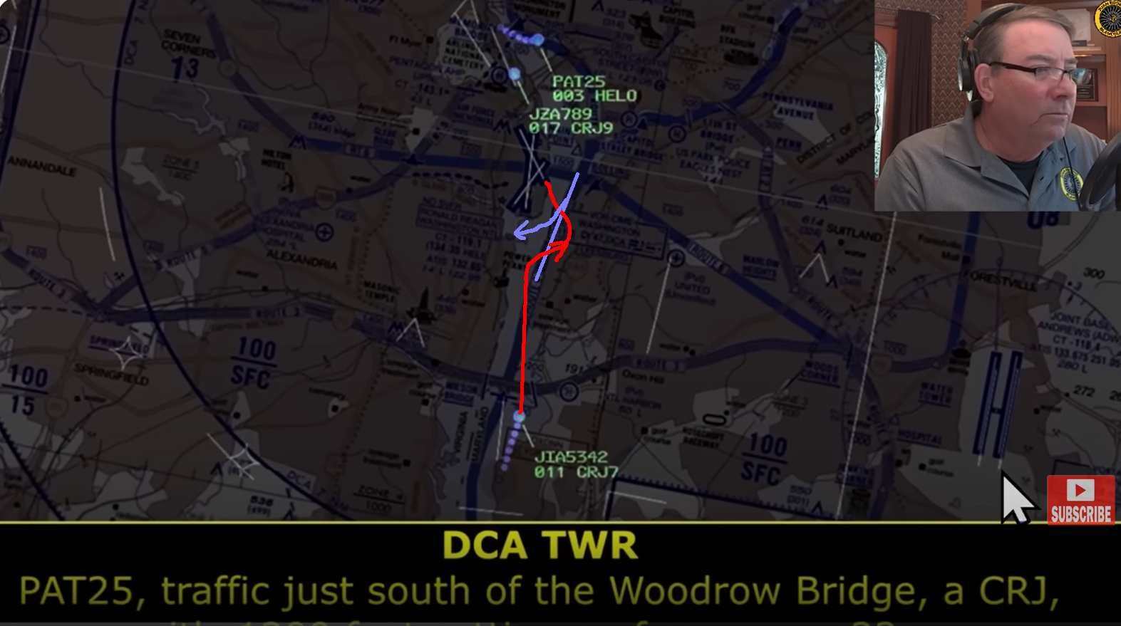
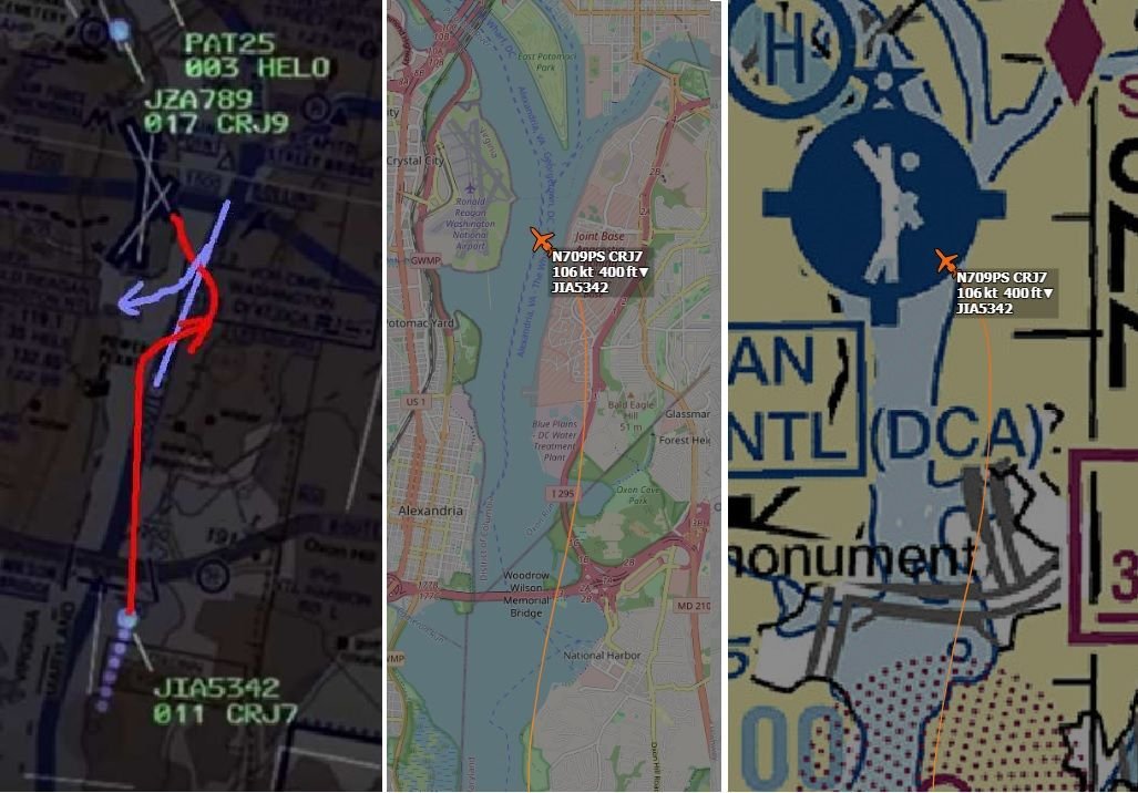
5. JIA342 is on approach for RWY 01, but is asked at the last minute by ATC to deviate to RWY 33, requiring the “circle to land” maneuver. Therefore, they are now on approach different from what they briefed for.
6. Any aircraft following the “circle to land” approach to RWY 33 will most likely have both pilots focused on RWY 33 as they come out of the left turn to final, especially if it was a last-minute request by ATC. In this case they will be looking to make sure that AA1630, which has just been given clearance to depart from RWY 01, is clear of the intersection with RWY 33 as they complete their final approach, and be ready for a go-around if it is not. In addition, this left bank makes it extremely difficult for the first officer to see any conflicting traffic coming towards them from the 1 to 2 o’clock position, as that traffic will probably be below the right window level. For the pilot, who is on the left side of the cockpit, visibility of such conflicting traffic will be nearly impossible.
7. For whatever reason, ATC is working with “split frequencies while controlling this airspace, so that although the controller hears both the aircraft on approach and the helo traffic south-bound on “Route 1”, the pilots of those respective aircraft only hear information directed at them. Thus they are not aware of all that is going on around them, and as such their situational awareness is limited by factors outside of their control.
8. ATC informs PAT25 of the conflicting aircraft on approach for RWY 33 at 1200 feet MSL, but at the time, PAT25 is heading almost due east towards the Jefferson Memorial on Helo Route 4 while JIA342 (the CRJ) is executing its right turn departing from the RWY 01 approach and is now heading in a northeast direction as it prepares to make a hard left onto the RWY 33 short final approach. From their respective positions, PAT25 in all likelihood sees the landing lights of AA3130 which is trailing JIA342 and whose landing lights are pointed almost directly in his direction, and mistakenly identifies it as the aircraft approaching RWY 33. At no time does it appear that ATC notifies JIA342 of the conflicting helo traffic. They are most likely focused on their approach to RWY 33, which was just handed to them.
9. As JIA342 rolls out of its left hand turn to final on RWY 33, completing the deviation they were just handed and had not briefed for, it is now approaching the 9-11 o’clock position of PAT25. Since the pilot of PAT25 is on the right-hand side of the Blackhawk, visibility of the CRJ may be limited. Both pilots of PAT25 are now most likely visibly fixated on passing to the rear of AA3130, which is in their 1-3 O’clock position, and which is the conflicting aircraft they perceive as the one ATC initially warned them about.
10. ATC, now receiving a conflicting aircraft warning, asks PAT25 if they have JIA342 in sight. In the absence of any obvious difference from the first mid-identification of the conflicting traffic, confirmation bias raises its ugly head. The voice response from the training pilot is calm and confident in stating that they do have it in sight and claim visual separation, probably proving once again that he mistakenly has AA3130 in sight slightly to his right directly in front of him and more than a mile away. Both pilots are totally unaware of JIA342 which is now arriving in front of them from their left.
11. The collision occurs.
In my humble opinion, the crews of both aircraft involved were set up by both the FAA and the Army Department of Aviation through a series of poorly based decisions which focused on expediency and departed from any appropriate utilization of a rational use of risk assessment. Consider the following:
1. Approval of the circling to RWY 33 maneuver which violates normal stabilized approach standards.
2. The establishment of a series of complex VFR helicopter track complex and heavily restricted air space as well as through final approach paths.
3. A 200 foot maximum altitude requirement over water and required even at night, which may result in a less than 200 foot vertical separation between aircraft on approach to RWY 33 and those traveling on Helo Route 1/4.
4. The decision to conduct military training missions in this complex and busy airspace with an abundance of commercial passenger traffic either arriving to or departing from DCA.
5. The use of split frequencies by the FAA which negatively impacts the situational awareness of all of the pilots in the airspace.
6. The use of night vision goggles to place even more limitations on the pilots.
Granted, all pilots involved may not have had the thousands of hours senior commercial and military pilot possess. But even the most senior individuals when placed in the task saturated environments these two crews faced would have at the very least felt their “pucker factor” increase through this. And there is probably an equal chance that the lack of common sense and appropriate safety design exhibited by the controlling entities would have resulted in a similar outcome. The odds were significantly stacked against these two flight crews, and unfortunately, against the passengers and flight attendants as well. If ever there were an example of an accident waiting to happen, this is it.
Subjects
ATC
Accident Waiting to Happen
Blackhawk (H-60)
CRJ
DCA
FAA
NTSB
PAT25
Route 4
Separation (ALL)
Situational Awareness
VFR
Vertical Separation
Visual Separation
Links are to this post in the relevant subject page so that this post can be seen in context.
Reply to this quoting this original post. You need to be logged in. Not available on closed threads.
February 03, 2025, 01:52:00 GMT
permalink Post: 11820222
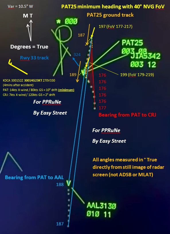
My marked up version of the radar plot now shows the heading of PAT25 at the first and penultimate sweep, based on the ground track as measured directly from the plot and assuming that the wind is at the non-gust value from the METAR observation taken just 4 minutes later (making this a reasonable minimum drift). It also shows the 40 degree field of view of the AN/AVS-9 NVG, drawn assuming both pilots are looking directly ahead along aircraft centreline.
The take-away is that with these assumptions, the CRJ starts on the extreme left hand edge of the NVG field of view and then moves just out of it. The PAT25 pilots would only see the CRJ in NVG if they turned their heads left of aircraft centreline to search for it. Since they thought they had visual contact, presumably with AAL3130, they would have no reason to do so.
Subjects
CRJ
Night Vision Goggles (NVG)
PAT25
Radar
Links are to this post in the relevant subject page so that this post can be seen in context.
Reply to this quoting this original post. You need to be logged in. Not available on closed threads.
February 03, 2025, 08:36:00 GMT
permalink Post: 11820320
These were 5 aviation professionals who had gotten their roles through hard work and perseverance (like all aviation professionals) and fell victim to the circumstances they found themselves in that night.
Speaking to some of my colleagues who have used NVGs operationally, they say they do reduce your field-of-view and flatten depth perception - one said he had mistaken a star for another aircraft for a while; it was only further away than he thought by a factor of ten trillion...
Subjects
ATC
CRJ
Close Calls
DCA
Night Vision Goggles (NVG)
Links are to this post in the relevant subject page so that this post can be seen in context.
Reply to this quoting this original post. You need to be logged in. Not available on closed threads.
February 03, 2025, 11:08:00 GMT
permalink Post: 11820420
9. As JIA342 rolls out of its left hand turn to final on RWY 33, completing the deviation they were just handed and had not briefed for, it is now approaching the 9-11 o\x92clock position of PAT25. Since the pilot of PAT25 is on the right-hand side of the Blackhawk, visibility of the CRJ may be limited. Both pilots of PAT25 are now most likely visibly fixated on passing to the rear of AA3130, which is in their 1-3 O\x92clock position, and which is the conflicting aircraft they perceive as the one ATC initially warned them about.
Subjects
ATC
Blackhawk (H-60)
CRJ
DCA
Night Vision Goggles (NVG)
PAT25
Route 4
Links are to this post in the relevant subject page so that this post can be seen in context.
Reply to this quoting this original post. You need to be logged in. Not available on closed threads.
February 03, 2025, 11:32:00 GMT
permalink Post: 11820440
You have not fully understood. In your world, ATC would not give any instructions to the helicopter, becauuse that 150ft was OK as separation minima. Instead in this world ATC relied (by request and reply) on the helicopter to identify visually the conflict, take the deconfliction in its own hands and adjust his flight path horizontally such that it places them well behind the CRJ (and its wakes). I.e. left turn towards the city and then once CRJ passes your 4 o'clock return to the river corridor by own navigation.
Now thats the 2D view. At 200ft-max altitude you dont turn at night from the river towards the city to position yourself east of, and then behind the CRJ on the 1 mile final...so what-else?
Subjects
ATC
CRJ
Separation (ALL)
Links are to this post in the relevant subject page so that this post can be seen in context.
Reply to this quoting this original post. You need to be logged in. Not available on closed threads.
February 03, 2025, 12:58:00 GMT
permalink Post: 11820516
As far as I can see, the helicopter crew when asked twice if they had the CRJ in sight responded in the affirmative both times. I think it's a tad unfair to criticise the controller for not being able to divine that they were actually looking at a different aircraft in the approach sequence.
Subjects
ATC
CRJ
Links are to this post in the relevant subject page so that this post can be seen in context.
Reply to this quoting this original post. You need to be logged in. Not available on closed threads.
February 03, 2025, 13:58:00 GMT
permalink Post: 11820556
Edit: after correcting the calculation with the fact that the PAPI is 350 ft before the TDZ, the angle for 325 ft altitude is rather 3\xb0 48 minutes, well into the 4 whites range.
Last edited by Luc Lion; 3rd February 2025 at 14:35 . Reason: correction
Subjects
CRJ
NTSB
Links are to this post in the relevant subject page so that this post can be seen in context.
Reply to this quoting this original post. You need to be logged in. Not available on closed threads.
February 03, 2025, 14:07:00 GMT
permalink Post: 11820561
This was discussed earlier, with several posts being based on listening to an incomplete ATC recording which failed to pick up the (UHF) frequency on which the helicopter crew were responding.
As far as I can see, the helicopter crew when asked twice if they had the CRJ in sight responded in the affirmative both times. I think it's a tad unfair to criticise the controller for not being able to divine that they were actually looking at a different aircraft in the approach sequence.
Subjects
ATC
CRJ
Close Calls
Pass Behind
Pass Behind (All)
Radar
Links are to this post in the relevant subject page so that this post can be seen in context.
Reply to this quoting this original post. You need to be logged in. Not available on closed threads.
February 03, 2025, 14:07:00 GMT
permalink Post: 11820562
* Not to say anything against the CRJ pilots, when getting night runway changes at DCA myself I would line up first and deal with the PAPI second. Flying over black water in the dark that seems a normal thing to do.
Subjects
CRJ
DCA
NTSB
Links are to this post in the relevant subject page so that this post can be seen in context.
Reply to this quoting this original post. You need to be logged in. Not available on closed threads.
February 03, 2025, 14:29:00 GMT
permalink Post: 11820584
If we assume that the collision occurred over the water close to the eastern bank, that gives a distance to the TDZ of 4900 ft.
And the PAPI is even closer than the TDZ.
If we then assume a plane spot on the glide of 3.00\xb0.
4900 ft * tan(3\xb0) = 257 ft
257 ft + 13 ft (TDZ altitude) = 270 ft AMSL
However, as several posters have highlighted, the plan was NOT to have the helicopter route underneath the CRJ.
Last edited by Luc Lion; 3rd February 2025 at 14:40 .
Subjects
CRJ
Links are to this post in the relevant subject page so that this post can be seen in context.
Reply to this quoting this original post. You need to be logged in. Not available on closed threads.
February 03, 2025, 14:45:00 GMT
permalink Post: 11820598
But the controller doesn\x92t know they have the wrong plane. Guess: he\x92s just checking they didn\x92t think they\x92d passed it already.
Either way, the controller does not have enough information to use a heading \x97 neither to know one is needed nor what it should be . The radar & display is just not as accurate as a Mark I eyeball in one cockpit seeing the other plane out the window.
When would he? \x93Tower, PAT25 has lost that traffic\x94. Until then a vector might bring them *into* a collision.
Subjects
ATC
CRJ
Close Calls
PAT25
Pass Behind
Pass Behind (All)
Radar
Links are to this post in the relevant subject page so that this post can be seen in context.
Reply to this quoting this original post. You need to be logged in. Not available on closed threads.
February 03, 2025, 15:50:00 GMT
permalink Post: 11820651
On the general subject of the 2nd Twr call to PAT25 and issuing avoidance instructions from BS5342, my take would be that maybe Twr saw it so late and simply didn't have an accurate mental picture of the precise trajectories of the helo and the CRJ to actually formulate a plan to deconflict safely. The only hope was that the helo crew "still" had the aircraft in sight (as they had already stated they had) and were still going to pass behind the CRJ............. Sadly, by then, that was just wishful thinking. At that late stage, all ATC probably knew was that ordering an evasion maneuver was just as likely to turn a near-miss into an accident as it was to turn an accident into a near-miss. A "Rock and a hard place springs" to mind....... One can only feel for the ATCO ...............
Subjects
ATC
ATCO
CRJ
DCA
PAT25
Pass Behind
Pass Behind (All)
Links are to this post in the relevant subject page so that this post can be seen in context.
Reply to this quoting this original post. You need to be logged in. Not available on closed threads.
February 03, 2025, 16:04:00 GMT
permalink Post: 11820658
Subjects
CRJ
Links are to this post in the relevant subject page so that this post can be seen in context.
Reply to this quoting this original post. You need to be logged in. Not available on closed threads.
February 03, 2025, 16:21:00 GMT
permalink Post: 11820674
If the guess that PAT25 saw the traffic for 01 (further south,who was #2 for landing, with the CRJ being #1) and not the traffic for 33, they were still advised by ATC to pass behind their traffic .
As you look at the various diagrams of the final geometry, with their initial southerly heading, any right turn would have them pass in front of the traffic approaching 01 (and yes, also it would cause them to cross in front of landing traffic for 33 if they saw that, though it appears that they didn't.).
Why the right turn rather than simply following the east bank (of the declared route) until the traffic that they did see (apparently the aircraft approaching 01) was passing their right side?
It makes no sense to me.
It appears that poster 51bravo has made a similar observation, worded differently.
If what you suggest is true, that neither pilot in the cockpit was familiar with the runway lay out of National(Reagan) Airport, that's an enormous hole in a slice or three of the cheese. I expect that subtle details like this may, or may not, eventually come out as the investigation progresses.
For patrickal:
While I appreciate the effort your put into that extended analysis, you are quite wrong about what a training mission is, the least of which is why one needs to do actual flying in an area to be competent in a given operations area, and why you have to do them in daylight and at night since your mission will call on your unit to undertake that mission, VIP transport, day or night.
The airspace in and around DC, writ large, is one of that unit's required operations area.
Your point 11 has so many things wrong about it that I won't waste further time on it.
In terms you might understand: no sale.
Last edited by Lonewolf_50; 3rd February 2025 at 16:45 .
Subjects
ATC
CRJ
DCA
Night Vision Goggles (NVG)
PAT25
Pass Behind
Pass Behind (All)
Links are to this post in the relevant subject page so that this post can be seen in context.
Reply to this quoting this original post. You need to be logged in. Not available on closed threads.
February 03, 2025, 18:11:00 GMT
permalink Post: 11820767
I fully sign your deduction, but granted your assumptions are true that PAT25 was mentally focused on passing behind AA3130 (which I fully believe too), but they also received the information that it is RWY33 that is to be used for landing of the CRJ. So why for gods sake did they continue into 33 runway extension before AA3130. Was there also a disorientation towards their current position relative to DCA runway systems and they also easily (at night, mental bias) took RWY01 for RWY33 ? It almost looks so. Once more the narrow vision of NVG cheese slice ?!
Subjects
CRJ
DCA
Night Vision Goggles (NVG)
PAT25
Links are to this post in the relevant subject page so that this post can be seen in context.
Reply to this quoting this original post. You need to be logged in. Not available on closed threads.
February 03, 2025, 20:31:00 GMT
permalink Post: 11820870
Subjects
ATC
CRJ
PAT25
Pass Behind
Pass Behind (All)
Links are to this post in the relevant subject page so that this post can be seen in context.
Reply to this quoting this original post. You need to be logged in. Not available on closed threads.
February 03, 2025, 20:38:00 GMT
permalink Post: 11820877
Subjects
CRJ
Pass Behind
Pass Behind (All)
Links are to this post in the relevant subject page so that this post can be seen in context.
Reply to this quoting this original post. You need to be logged in. Not available on closed threads.
February 03, 2025, 21:26:00 GMT
permalink Post: 11820910
Last edited by spornrad; 3rd February 2025 at 23:06 .
Subjects
CRJ
Circle to Land (Deviate to RWY 33)
Pass Behind
Pass Behind (All)
Links are to this post in the relevant subject page so that this post can be seen in context.
Reply to this quoting this original post. You need to be logged in. Not available on closed threads.
February 03, 2025, 22:46:00 GMT
permalink Post: 11820975
No crossing of 'Route 4' prior to ...
Subjects
CRJ
Circle to Land (Deviate to RWY 33)
Pass Behind
Pass Behind (All)
Route 4
Links are to this post in the relevant subject page so that this post can be seen in context.
Reply to this quoting this original post. You need to be logged in. Not available on closed threads.
February 03, 2025, 23:43:00 GMT
permalink Post: 11821022
I agree that these are just guesses, but the alternative seems to be that the helo just drifted to the right randomly, for no specific reason, which seems unlikely.
Subjects
CRJ
Radar
Route 4
Separation (ALL)
Links are to this post in the relevant subject page so that this post can be seen in context.
Reply to this quoting this original post. You need to be logged in. Not available on closed threads.