January 30, 2025, 09:01:00 GMT
permalink Post: 11817018
At 300 ft doglegging onto a different runway in an airliner (whaaat??? Who the digamma thought that one up! No wonder Lufthansa refused it!) there's zero lookout for traffic going on.
Having spent much helo time over cities at night even at 800ft (the lowest I ever operated) you don't have too much attention left to scan the skies for traffic, and if something was on a collison course its lights are on a constant bearing ie stationary against the background lighting and would be very difficult indeed to spot. Additionally you would naturally not be looking for traffic against the city lights but above it. Even strobes would easily be misconstrued as some of the numerous flashing lights seen in cities at night. And if the helo was on a training flight both pilots' attention on surroundings is likely to be less than might be expected otherwise.
Compared to the stringent control of the London Helilanes and rigid procedures especially closer to Heathrow this entire airspace setup looks simply beyond belief from a European point of view.
Last edited by meleagertoo; 30th January 2025 at 10:35 .
Subjects
Circle to Land (Deviate to RWY 33)
Night Vision Goggles (NVG)
Links are to this post in the relevant subject page so that this post can be seen in context.
Reply to this quoting this original post. You need to be logged in. Not available on closed threads.
January 30, 2025, 09:10:00 GMT
permalink Post: 11817027
Military Operations are 24/7/365 due to National Security issues.
https://www.loc.gov/resource/g3851p....,0.268,0.125,0
I have never flown there but if there's regular helicopter traffic 150ft below an ILS or circling approach airline crews familiar with the airport might tend to disregard TCAS proximate traffic, etc. as normal backdrop chatter.
Even when flying behind similar aircraft on an ILS in daylight and good visibility it takes quite some time to see that preceding traffic is slowing down as it only starts to "grow" at an alarming rate when quite close. I have witnessed that twice, once caused by self and another time caused by mismatched speed instructions from ATC. I have resolved to never accept visual separation to preceding traffic at night and while the European aversion to visual approaches might be excessive, high density night ops based on visual separation don't seem to be a good idea even without that crash.
Subjects
ATC
Altimeter (All)
Circle to Land (Deviate to RWY 33)
Radar
Route 4
Separation (ALL)
TCAS (All)
Visual Separation
Links are to this post in the relevant subject page so that this post can be seen in context.
Reply to this quoting this original post. You need to be logged in. Not available on closed threads.
January 30, 2025, 10:22:00 GMT
permalink Post: 11817092
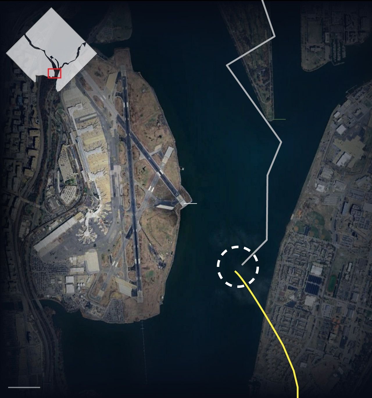
Or could the circling approach from 01 to 33 also be a factor with the helo misinterpreting the CRJ flight path and somehow losing sight ? The track of both aircraft is interesting\x85 helo seems to initially be parallel to the river bank and turns 40 right. Why ? Was their destination the same airport or was that manoeuvre related to traffic avoidance or loss of visual ?
All guesswork I know\x85 putting Special VFR traffic so close to final approach traffic at night clearly a problem. Tragic.
Subjects
CRJ
Circle to Land (Deviate to RWY 33)
Traffic in Sight
VFR
Links are to this post in the relevant subject page so that this post can be seen in context.
Reply to this quoting this original post. You need to be logged in. Not available on closed threads.
January 30, 2025, 13:20:00 GMT
permalink Post: 11817228
Or could the circling approach from 01 to 33 also be a factor with the helo misinterpreting the CRJ flight path and somehow losing sight ? The track of both aircraft is interesting… helo seems to initially be parallel to the river bank and turns 40 right. Why ? Was their destination the same airport or was that manoeuvre related to traffic avoidance or loss of visual ?
All guesswork I know… putting Special VFR traffic so close to final approach traffic at night clearly a problem. Tragic.
The golf course is on a peninsula in the river, so the helicopter was flying over water before and after it made the two turns.
Subjects
CRJ
Circle to Land (Deviate to RWY 33)
VFR
Links are to this post in the relevant subject page so that this post can be seen in context.
Reply to this quoting this original post. You need to be logged in. Not available on closed threads.
January 30, 2025, 13:35:00 GMT
permalink Post: 11817237
Subjects
Circle to Land (Deviate to RWY 33)
Links are to this post in the relevant subject page so that this post can be seen in context.
Reply to this quoting this original post. You need to be logged in. Not available on closed threads.
January 30, 2025, 13:42:00 GMT
permalink Post: 11817246
And the helo was apparently flown by a trainee ...
Subjects
Circle to Land (Deviate to RWY 33)
DCA
Pass Behind
Pass Behind (All)
Links are to this post in the relevant subject page so that this post can be seen in context.
Reply to this quoting this original post. You need to be logged in. Not available on closed threads.
January 30, 2025, 14:37:00 GMT
permalink Post: 11817286
Subjects
Circle to Land (Deviate to RWY 33)
Links are to this post in the relevant subject page so that this post can be seen in context.
Reply to this quoting this original post. You need to be logged in. Not available on closed threads.
January 30, 2025, 14:44:00 GMT
permalink Post: 11817291
Subjects
Circle to Land (Deviate to RWY 33)
Links are to this post in the relevant subject page so that this post can be seen in context.
Reply to this quoting this original post. You need to be logged in. Not available on closed threads.
January 30, 2025, 15:23:00 GMT
permalink Post: 11817324
Approach traffic seems to be approx 400-500ft at this point.
Which turnip decided it would be OK to allow vertical separation of 300ft on a busy approach path? And allow it VFR at night?
This accident was baked in. Bound to happen at some point.
In this case, the aircraft was flying an approach to one runway with a circle-to-land on RW-33. Ask any pilot; a circle to land in itself ups the work load. The margin for error of any kind at DCA is small and the 5200 foot runway isn't all that long. Even on a simple landing where none of these considerations are an issue, at some point the pilots reduce their "see and avoid" efforts and concentrate their efforts on achieving the proper line up and glide slope, rate of descent, aircraft configuration, flap setting, etc. etc. etc. In other words, the complicated routine required to safely land an airliner these days is already close to task overload even when things are going well. Add in the fact that it's night time at a very busy airport and looking out the window gets shoved pretty far down the "to do" list. But generally speaking, the system works because big busy airports pretty much operate using IFR rules and nearly all the aircraft are under close control. I other words, even on a crystal clear day under VFR flight conditions, someone is keeping a very close eye on the airliners coming and going from major airports. If a pilot makes a mistake and levels off at the wrong altitude, for example, there is a very good chance a controller will catch that error immediately even on a sunny VFR day. And that's a good thing because truth-be-told, when an airliner is seconds from touch down these days, there isn't much "see and avoid" going on. That's just the way it is.
But apparently DCA routinely has all sorts of helo traffic buzzing around under modified VFR flight rules. The pilots are talking to a controller but without being under the same sort of close control which is usually associated with how airliners operate. And they do that night and day, trusting the helo pilots to not make a mistake. But it looks like someone DID make a mistake last night and nobody caught it in time.
Subjects
ATC
Circle to Land (Deviate to RWY 33)
DCA
FAA
IFR
Route 4
See and Avoid
Separation (ALL)
VFR
Vertical Separation
Links are to this post in the relevant subject page so that this post can be seen in context.
Reply to this quoting this original post. You need to be logged in. Not available on closed threads.
January 30, 2025, 17:10:00 GMT
permalink Post: 11817417
I couldn't find any NOTAM that would have signaled a non-functioning PAPI and, in a clear night, any trained pilot would follow the PAPI indication out of force of habit.
starting at the Visual Guidance Fix (VGF) IDTEK which is overhead of the motorway I-295 (if I am not mistaken).
I think that it is reasonable to assume that the pilot would have aimed at passing overhead IDTEK at 490 feet MSL as specified in the RNAV procedure.
IDTEK is about at 1.4 nm or 8500 ft from the threshold or about 9600 ft from the TDZ.
With a published PAPI glideslope of 3.00\xb0, the glideslope path is at about 500 ft MSL at IDTEK
And the distance TDZ - threshold is about 330 m for this runway.
With some trigonometric calculation, you end up with a height between 229 and 263 feet above runway TDZ, under the assumption that the plane was spot on the glide.
Subjects
CRJ
Circle to Land (Deviate to RWY 33)
Radar
VFR
Links are to this post in the relevant subject page so that this post can be seen in context.
Reply to this quoting this original post. You need to be logged in. Not available on closed threads.
January 30, 2025, 17:22:00 GMT
permalink Post: 11817431
In my opinion, there are way too many issues that contributed to this horrific incident.
An outdated airport that exists primarily for the benefit of the governing class. Seriously, take a few minutes to look at the approach plates - a circle to land approach to rwy 33, 5,200 ft, at night - really??
A video I watched this morning described the government priority parking spaces, special hotline to the airlines to hold planes for last minute departing bureaucrats. As noted above, for several years the destinations from KDCA were tightly controlled to limit the number of operations, yet this has been compromised by bureaucrats utilizing special privileges to lobby airlines to obtain direct flights to their home cities. After all, it\x92s a far longer drive to KIAD.
Apparently there was some talk years ago to utilize KADW, which is also close to the center of government as a replacement to KDCA, but the neighborhood didn\x92t want the noise.
I think the fact the helo was communicating with the KDCA tower on UHF, (SOP in that area) complicates the SA of all involved. Use of the NVG in the helo with a crew of 3 restricted the SA of the crew. An additional crew member on the helo may have helped.
As mentioned, USA ATC hasn\x92t been up to the usual standards but have some empathy for these folks as staffing levels have significantly degraded and they are being asked to do more with less and I think all aircrew operating in the US are aware of this.
Trumps press conference never should have involved the political aspect, it really degrades the message to the victims families. This is an opportunity to fix the problems in the system, invest money in upgrading staffing levels and equipment and changing poor practices that have been accepted into the norm.
Subjects
ATC
Circle to Land (Deviate to RWY 33)
KDCA
Night Vision Goggles (NVG)
Situational Awareness
Links are to this post in the relevant subject page so that this post can be seen in context.
Reply to this quoting this original post. You need to be logged in. Not available on closed threads.
January 30, 2025, 17:35:00 GMT
permalink Post: 11817451
In my opinion, there are way too many issues that contributed to this horrific incident.
An outdated airport that exists primarily for the benefit of the governing class. Seriously, take a few minutes to look at the approach plates - a circle to land approach to rwy 33, 5,200 ft, at night - really??
A video I watched this morning described the government priority parking spaces, .
I know exactly where the congressional parking lot is (it's under the elevated metro tracks - it's easy to identify since it's the only lot with American cars in it) It's not that great of a location. I went to the U DC A&P school and as a student, I literally had better parking spot.
This seems to be a lot of stuff pouring from people's heads totally unrelated to the actual event
Subjects
Accident Waiting to Happen
Circle to Land (Deviate to RWY 33)
Links are to this post in the relevant subject page so that this post can be seen in context.
Reply to this quoting this original post. You need to be logged in. Not available on closed threads.
January 30, 2025, 18:09:00 GMT
permalink Post: 11817487
it is easy to become disorientated at night particularly when making turns.
.the circling approach to r/w 33 seems demanding and pitot lookout would be focused on the runway not peripheral traffic - turns prevent all round lookout protection .
. The helo pilots could have sighted other traffic or moving lights on the ground - things happen very fast.
as stated earlier this was an accident waiting to happen - allowing VFR traffic to pass that close to traffic on short finals is crazy
with reliable engines,modern glass cockpits and brilliant nav aids flying has become a whole lot safer - mid air collisions in VFR / VMC remain high risk especially at low level if TCAS is unreliable and when weather is marginal.
the human eyeball has it\x92s limitations
PS are ATC urgent instructions ever misunderstood or not received because of comm faffs or language / regional accent misunderstandings ?
Subjects
ATC
Accident Waiting to Happen
Circle to Land (Deviate to RWY 33)
TCAS (All)
VFR
Links are to this post in the relevant subject page so that this post can be seen in context.
Reply to this quoting this original post. You need to be logged in. Not available on closed threads.
January 30, 2025, 20:22:00 GMT
permalink Post: 11817621
Subjects
ATC
Circle to Land (Deviate to RWY 33)
DCA
Separation (ALL)
Visual Separation
Links are to this post in the relevant subject page so that this post can be seen in context.
Reply to this quoting this original post. You need to be logged in. Not available on closed threads.
January 31, 2025, 00:53:00 GMT
permalink Post: 11817814
The aircraft was flying a circling approach off an ILS, not a 'vectored' approach.
VMC & IMC are weather conditions, not flight rules. The weather at the time was absolutely VMC.
It is absolutely normal to disconnect the AP well above DH/MDA, it happens the vast majority of the time, worldwide.
Last edited by gretzky99; 31st January 2025 at 01:21 .
Subjects
Circle to Land (Deviate to RWY 33)
Links are to this post in the relevant subject page so that this post can be seen in context.
Reply to this quoting this original post. You need to be logged in. Not available on closed threads.
January 31, 2025, 14:47:00 GMT
permalink Post: 11818263
The NASA ASRS database contains safety reports raised over the US. A quick search with the term “helicopter” produced 40+ reports with the highlights shown below.. (apologies, to save time these are all copy and pasted) There are more, but I appreciate that most of us have annual eye examinations to pass so didn’t want to overdo it!
1. While we were flying the river visual to Runway 19 into DCA we received a TCAS alert. We were around SETOC or just past it and fully configured to land. There was, what I could only guess as I never saw it, a helicopter about 300ft below us. The TCAS showed it climbing but at a very very slow rate as it never showed closer than 300ft to us. When we flew over top of it, we got a “monitor vertical speed alert from TCAS which we then pitched into the green arc on the VSI which was -300fpm or greater. After we received the “clear of conflict” the FO corrected and got back on glide path. I assessed that we were still within stable approach criteria and we continued the approach and landed in DCA without further issue. We never received a warning of the traffic from ATC so we were unaware it was there. Suggestion: Need to have better separation for DCA traffic on the river visual to the helicopter traffic that is flying up and down the river. Maybe by timing the separation of when we began the approach to where that traffic will be when we cross overhead.
2. ATC delayed switch from Approach to Tower led to TA and resulting altitude deviation causing a GPWS Caution. Tower then issued a low altitude alert. Helicopter traffic was heading up the Potomac while we were on the river visual approach did not alert us to the on coming traffic. By the time Tower responded we had a RA to descend which led to a GPWS and low altitude alert from Tower. We confirmed traffic in sight and maneuvered back on coarse to correct the deviation, in judgement the safety of flight was not compromised as such we continued the approach to landing on Runway 19. As I believe a go-around would have exacerbated the situation and led to further problems.
3. I was working the Local and Helicopter positions combined at DCA ATC. I have been CPC/FPL for [a short time].
I accepted a handoff from Potomac TRACON on Aircraft X 2 miles west of ZZZ. Aircraft X contacted DCA Tower and requested to fly Route 1-Route 4 -ZZZ1 and then to ZZZ2. I radar contacted Aircraft X, approved the request and issued the altimeter.
Aircraft Y called on a seven mile final to DCA and requested to land on Runway XX. I then I cleared Aircraft Y to land.
Note. My standard practice for helicopter s flying the DCA helicopter route is to issue any pertinent landing traffic by the time the helicopter s pass over the South Capitol Street Bridge.
Aircraft X asked if I had issued traffic on the aircraft landing Runway XX. I thought I had applied my standard practice of issuing traffic to the helicopter s over the bridge so I informed Aircraft X that I had issued the traffic.
Once Aircraft Y landed, he asked about the flight of three helicopter s off his right. I informed him I had issued traffic to Aircraft X.
Neither aircraft declared a near miss on frequency. At all times I had maintained Tower applied visual separation between Aircraft X and Aircraft Y.
I recommend recurrent helicopter training for the facility to prevent this incident from occurring in the future with other controllers.
4
Our flight] into DCA was in a NMAC. We were supposed to circle from the visual Runway 1 to instead land on 33. We followed the [company] station bulletin procedures exactly as planned and came within very close contact of another aircraft. This occurred about 400 feet off the ground to the point where the pilot monitoring had to take the controls to make a correction in order to prevent it from becoming a midair collision. After there was action taken to make a correction from the close call, we were then informed by DCA tower of close traffic although at that point it would have been too late. I have flown with people who for the purpose of having a better chance of a stabilized approach would have had a wider circle to land procedure which I'm sure would have almost definitely ended in the collision of two aircraft over the turn to final for 33 in DCA. There was an extreme lack of communication between DCA Tower to [our flight] or DCA Tower to the associated helicopter who did not ever pop up on TCAS which I'm assuming is due to a lack of an operating transponder. No TCAS RA was associated with this event.
This occurred due to an extreme lack of communication between DCA Tower and [our flight] or DCA Tower and the associated helicopter . Otherwise the other reason this may have happened is because of an unclear idea of where aircraft should be located during Runway 33 circle to land operations. I believe I was on track with what the [company] guidelines are for that particular procedure but there is a possibility that the other traffic operating around that area may not be aware of where exactly we are located or maybe they don't have a specific guideline to keep the arriving traffic separated from the low flying helicopter s.
5
I understand DCA is a busy airport, I was based there for years. The military low level helicopter traffic that routinely is in the DCA traffic area complicates matters. But this is probably the most dangerous airport in the United States, strictly based on the the fact the controllers are pushing, pushing, pushing, in an attempt to handle the traffic they have.
6
We were cleared to circle to and land on runway 33. ATC also added that there was a low level helicopter and that the helicopter had us in
sight. At the Wilson bridge we turned to the northeast to set ourselves up for a landing on runway 33. We continued normally and started our turn to final.
when I saw an opposite direction helicopter very close to our altitude, but slightly below us and climbing. I was about to initiate the go around
regardless of the TCAS when we got the RA. As we started the go around I saw the helicopter make an aggressive descent. We were given a
turn to the east and a climb to 2,000 feet which we complied with. After that, we cleaned up the plane, setup for another approach, and landed
on runway 1 without incident. Once we cleared the runway, ground control asked me if I wanted to call the DCA tower supervisor for an
explanation of what happened. I gladly accepted. The tower supervisor I spoke with told me a few things that explained what may have
happened. Number one, he said that the helicopter s operating in that area should NEVER be above 200 feet. According to him, the helicopter
was at 800 feet, clearly not where he was supposed to be. He also explained that ATC may have taken their eyes off the helicopter for a
second because they would never expect those helicopter s to do something that egregious. That seems plausible given the fact that I've
never seen a helicopter in that area at that altitude. He suggested that it was most probably a deviation on the part of the Pilot of the
helicopter , and a loss of aircraft separation that was also the fault of the helicopter pilot.
Helicopter pilots in and around DCA should adhere to ATC instructions.
7
It was the end of a long day and the events were happening very quickly during a high workload portion of the flight. As all pilots know, the River Visual is a very demanding approach during the best of circumstances. It is very labor intensive when done at night during periods of high traffic volume. The advertised approach in use at DCA was the LDA 19 with VASI being out of service. During the initial approach, Potomac asked if we would accept the charted River Visual approach (VASI back working) and we did. At approximately the 7 DME point we were in the end process of configuring the airplane for landing and the First Officer was accomplishing the Landing Checklist. The radio chatter was considerable and the Tower at some point advised us of helicopter traffic ahead and to the left (I believe he said 10 to 11 o'clock) and he was going to pass from left to right, below us and he "HAS US IN SIGHT." It has to be noted that these traffic calls and helicopter s have unfortunately become background noise. There are always numerous military and government helicopter s running up and down that river at all times of the day and night. Because of this, what would normally be alarming at any other airport in the country has become commonplace at DCA. The FAA allows these aircraft to operate in this environment and we have no choice, but to accept it and deal with it. Therefore, the helicopter s being very close are not out of the norm. As you can imagine, I was concentrating on the approach and doing the required gyrations to stay over the river and not violate the White House prohibited airspace, and to keep the aircraft on the proper vertical profile. The Runway 19 visual was loaded in the FMGC and I was using it as a backup to my eyes. I was 'dead on' the donut and everything looked normal. I was at or very slightly above the recommended altitudes at each DME point. As I was approaching 4 DME, I caught a glimpse of the helicopter out of my left window and he did look higher than I expected to see him. I asked the First Officer to confirm if he was going to cross from north to south. He confirmed, however I directed him to ask the Tower and confirm it with them because it did not look right. The First Officer could not get a word in with the Tower. It was at that point, we got a TCAS "TRAFFIC" call. Again, this is not out of the 'norm' for DCA. I was getting ready to take possible evasive action because it was getting uncomfortable; all this while trying to fly the demanding profile. Within seconds, we got a TCAS alert, "MONITOR VERTICAL SPEED." I complied with the TCAS alert and was thinking of going around but it all happened so very quickly that the point was moot. The helicopter passed 200 FT (MAX) below us. We were at 900 FT, slightly above the path. The Tower never called out the traffic beyond the first notification. The landing was uneventful. Due to the workload, we asked the Ground Controller for the Tower number and I called when I got to my vehicle. I called the Tower and spoke with the Controller in charge. At first it was it was obvious he was somewhat on the defensive and I had to press the point and ask very specific questions about the standard helicopter operations in the area. After some prodding, he admitted that it was a military helicopter flying from/to Ft. Meade and that he was at 700 FT and was "a little higher than normal." I asked what altitude was he supposed to be at and he replied, "three to four hundred feet." In addition, he did admit that the Tower version of collision avoidance did go to alarm but before they had a chance to react, the event was over. I cannot imagine what business is so pressing that these helicopter s are allowed to cross the path of airliners carrying hundreds of people! I do not understand why they are not crossed IN-BETWEEN arrivals. They have at least 4 miles between these arriving aircraft and it seems that would be more prudent.
8
We were on the Mount Vernon Visual Approach to Washington National Airport, and the Tower instructed us to circle to land on Runway 33. While we made our approach to Runway 33, Tower advised a helicopter was maneuvering at our 12 o'clock position. As we continued our approach, Tower instructed the helicopter to "make a right 360 for a jet on a 2 mile final for Runway 33, and to report him in sight" (referring to our aircraft.)
The Tower then asked the helicopter if he had us in sight. He replied "yes", and the Tower told him to maintain visual separation. As we began our turn from base to final, the helicopter made what looked like a right turn directly into our flight path. The Captain, the pilot flying, made a hard right turn and executed a missed approach to avoid a collision. I'm not sure how close we came to the helicopter since it was on the left side of the aircraft, but I would guess it was only a few hundred feet.
9
WE WERE EXECUTING AN ILS IN IMC. AS MY FO ANNOUNCED 'APCHING MINIMUMS, RWY IN SIGHT,' I BEGAN MY TRANSITION FROM FLT DIRECTOR REF TO VISUAL REF FOR A HAND FLOWN LNDG. MY AIRSPD WAS PROBABLY AROUND 130-135 KIAS. AS I WAS TRANSITIONING I SUDDENLY SAW A DARK COLORED MIL HELI ON MY APCH PATH. HE BLENDED IN VISUALLY WITH THE DISMAL WX CONDITIONS. I DID NOT NOTICE ANY ACFT LIGHTING. AS I SAW HIM, SO DID THE DCA TWR CTLR. THE CTLR ISSUED AN IMMEDIATE AND FORCEFUL ATC INSTRUCTION TO THE HELI. THE HELI EXECUTED AN ABRUPT EVASIVE MANEUVER AND DISAPPEARED INTO THE FOG. I LANDED SAFELY. THIS ENTIRE EVENT LASTED ABOUT 3-4 SECONDS. MY ACFT (BOEING 757) CONFIGN WAS GEAR DOWN, FULL 30 DEG FLAPS, ON SPD, ON COURSE, ON GLIDE PATH. EVASIVE MANEUVERING CAPABILITY IS LIMITED UNDER THESE CIRCUMSTANCES. MY ALT WAS ABOUT 300-400 FT ABOVE THE POTOMAC RIVER. ARPT TERMINALS AND CTL TWR WERE TO MY L, PROHIBITED AREA P-56 WAS TO MY R, AND THE HELI IN QUESTION WAS IN THE WX IN FRONT OF ME SOMEWHERE. I DIDN'T FEEL I COULD EXECUTE A MISSED APCH WITH THAT ACFT IN THE FOG IN FRONT OF ME. WE WERE STILL ON LNDG PROFILE AND I DECIDED LNDG WAS THE SAFEST COURSE AVAILABLE. WE MADE A NORMAL EXIT FROM THE RWY TO THE L WITH MUCH LNDG ROOM LEFT ON RWY 36. TAXIED TO THE GATE AND PARKED. MADE AN IMMEDIATE PHONE CALL TO THE TWR SUPVR AND RPTED THE INCIDENT. THEN CALLED MY AIRLINE FLT MGMNT SUPVRS AND RPTED THE INCIDENT AND MADE A WRITTEN RPT TO THE AIRLINE SAFETY DEPT UPON ARR AT MY BASE THAT NIGHT. I AM GLAD THE VISIBILITY WAS GOOD ENOUGH FOR THE CTLR TO SEE THE HELI IN TIME TO TAKE ACTION. IF THE VISIBILITY HAD BEEN ANY LESS HE WOULDN'T HAVE. CALLBACK CONVERSATION WITH RPTR REVEALED THE FOLLOWING INFO: RPTR STATES THAT DURING HIS SPEAKING WITH THE TWR FACILITY AT DCA, A CTLR IN TRAINING WAS HANDLING THE MIL TFC AT THE N END OF THE ARPT UNDER THE JURISDICTION OF ANOTHER, MORE EXPERIENCED, CTLR. THE SECOND CTLR IS THE ONE THAT TOOK OVER THE MIKE AND ORDERED THE HELI TO LEAVE THE APCH ENVIRONMENT OF THE LNDG TFC. THE RPTR STATES THAT HIS TRAINING WOULD NORMALLY CAUSE HIM TO EXECUTE A MISSED APCH BUT THAT THE POSSIBILITY OF ANOTHER ENCOUNTER WITH THE SAME ACFT SEEMED LIKE A GOOD POSSIBILITY AND SO DECIDED THAT LNDG WAS THE SAFEST PATH TO FOLLOW. HE SAID THAT THE PHONE CONVERSATION REVEALED THAT EXTENSIVE TRAINING FOR A MIL EXERCISE OR OP WAS IN PROGRESS AND WAS BEING STAGED FROM THE N PART OF THE DCA COMPLEX. THE RPTR DOESN'T KNOW WHETHER THE HELI PLT MISUNDERSTOOD HIS INSTRUCTIONS OR WHETHER THE CTLR ISSUED SUCH INSTRUCTIONS IN THE FIRST PLACE.
10
WE WERE ON THE RIVER VISUAL APCH TO RWY 18 AT DCA. THERE WAS A MIL HELI OPERATING A TRAINING FLT FLYING N TO S OVER THE RIVER AT 500 FT MSL. WE APPEARED TO BE AT LEAST 80 KTS FASTER (WHILE IN OUR LNDG CONFIGN) THAN THE HELI. TWR ADVISED US OF THE HELI AND THAT HE HAD US IN SIGHT AND HE WOULD MAINTAIN VISUAL SEPARATION WITH US. WE OVERTOOK ALMOST DIRECTLY ABOVE THE HELI AT ABOUT 3.5 DME AND 1100 FT MSL, RIGHT AT THE TURN IN THE RIVER THAT IS REQUIRED ON THE APCH. WE RECEIVED AN RA FROM OUR TCASII AT 1100 FT. WE FLEW AS FAR TO THE E SIDE OF THE RIVER AS WE COULD TO MAINTAIN VISUAL ON THE HELI ON THE W SIDE OF THE RIVER. WINDS WERE OUT OF THE SW AT 15-20 KTS. THE TCASII INDICATED CLR OF CONFLICT. WE STARTED TO DSND AGAIN AND AT 900 FT AGL, RECEIVED ANOTHER RA FROM OUR TCASII. AT THAT POINT IN THE APCH, THE RIVER TURNED BACK TO THE SSW. AS WE MADE OUR R TURN WE REGAINED VISUAL WITH THE HELI AND CONTINUED TO DSND. TCASII GAVE US 'CLR OF CONFLICT' AND WE FINISHED THE APCH AND LANDED. AFTER LNDG, I CALLED THE TWR SUPVR AND HE LISTENED AND SAID THIS WAS NORMAL. I HAVE FLOWN THIS APCH AT LEAST 15 TIMES AND I AM VERY FAMILIAR WITH THIS APCH. HOWEVER, I CONSIDERED THIS APCH PUSHING THE ENVELOPE FOR SAFETY, WITH THE AMOUNT OF ATTN I HAD TO GIVE TO THE HELI WHILE FOLLOWING THE RIVER AND DSNDING IN A XWIND AND AT A HIGH LNDG WT. THE TWR NEVER MADE IT CLR TO US WHERE THE HELI WAS GOING. ON THE PHONE THE SUPVR SAID THEY TRAIN FLYING N TO S AND BACK AT 500 FT. APPARENTLY, THEY DO THIS FROM 2 DME N TO 10 DME, BASICALLY UNDER THE WHOLE APCH. WHY CAN'T THEY DO THIS AFTER 10 O'CLOCK PM OR DURING LOW TFC FLOW PERIODS? AT THE VERY LEAST, THE ACFT SHOULD BE SPACED BETTER SO AS NOT TO FLY SO CLOSE TO THE HELI WHILE ON THE APCH. I HAVE ENCOUNTERED HELIS PREVIOUSLY WHILE SHOOTING THIS APCH, HOWEVER, THEY WERE ALWAYS CLOSER IN SPD TO US AND THEREFORE WE WOULD NOT OVERTAKE THEM AS FAST, OR WE WERE SPACED BETTER. ALSO, THEY ALWAYS HAD A DEST THAT WE WERE ADVISED OF. I'M SENDING IN THIS RPT BECAUSE I WAS NOT COMFORTABLE WITH THE LEVEL OF SAFETY INVOLVED WITH FLYING WITHIN 400 FT VERTLY OF A HELI AND THAT IS CONSIDERED A NORMAL OP.
11
DURING ILS APCH, SBOUND, HELI COMING DOWN POTOMAC RIVER ABOUT 500 FT MSL, TFC CALLED BY TWR, WE DIDN'T SEE IT. WE GOT AN RA ON TCASII -- HAD TO FOLLOW RA INSTRUCTIONS. THEN WE WERE HIGH ABOVE GS, HAD TO DSND MORE RAPIDLY THAN WE WANTED TO IN ORDER TO LAND. THIS HELI CONFLICT AROUND DCA IS A DAILY PROB! GOING TO TA ONLY ON TCASII WOULD DEFEAT PURPOSE OF TCASII. LNDG ACFT SHOULD NOT HAVE TO ACCOMMODATE HELI'S. THIS IS AN ACCIDENT WAITING TO HAPPEN.
12
I WAS TURNING FINAL FOR STOL LNDG RWY 21 DCA. I SAW A HELI APCHING ON CONFLICTING FLT PATH. IT WAS APPROX 400 FT BELOW US, BUT WE WERE DSNDING FOR LNDG. I ADVISED DCA TWR OF TFC. HE SAID 'TFC LOW LEVEL, 200 FT.' JUST AS I WAS GOING TO MANEUVER TO AVOID, THE CHOPPER MADE A STEEP TURN AWAY FROM US. AT THIS POINT WE WERE WITHIN 100 FT VERTICALLY AND 1000 FT HORIZLY. BECAUSE OF THE LIMITATIONS ON PERFORMING A STOL LNDG AT DCA, MY TURN TO AVOID HIM WOULD ALSO CAUSE A GAR. TWR HAD PUT US ON RWY 21 WHILE THE ARPT WAS IN A 'N' OP (ALL OTHER TFC LNDG ON RWY 36). I RECEIVED NO WARNING FROM TWR OF HELI TFC AND I HAD NO WAY OF KNOWING IF CHOPPER PLT HAD US IN SIGHT (UNTIL HE MADE THE EVASIVE TURN). THIS IS BY NO MEANS THE FIRST TIME OF SUCH AN OCCURRENCE AT DCA. I HAVE HAD MANY CONFLICTS WITH CHOPPERS, BOTH ON LNDG AND TKOF AT DCA. I HAVE TALKED TO TWR SEVERAL TIMES (INCLUDING THIS TIME) AND HAVE RECEIVED APOLOGIES AND ADMITTING OF ERRORS BUT THE PROB CONTINUES. THE HELI IS A VERY MANEUVERABLE ACFT. IF THE CHOPPER PLTS WOULD JUST GIVE US MORE SEPARATION, THE PROB WOULD BE SOLVED. WHEN THEY SEE US THEY COULD SLOW OR HOVER, TURN, ETC. CONFLICTS OCCUR WHEN TWR FORGETS TO ADVISE ME THAT CHOPPER HAS ME IN SIGHT AND THE CHOPPER MAINTAINS HIS 'TRAJECTORY' WHICH CONFLICTS WITH MY LIMITED ARR OR DEP AIRSPACE.
13
DURING RIVER VISUAL APCH DCA (LNDG RWY 18), 3 HELIS CROSSED OUR FLT PATH. THE FIRST CAUSED AN RA ON TCASII WITH A 0-300 FT CLB (WHICH WE FOLLOWED). THE HELI WENT DIRECTLY UNDER OUR ACFT WITH LESS THAN 300 FT SEPARATION. THE NEXT 2 HELIS CAUSED MONITOR VERT DSCNT ON THE TCASII. ALL 3 HELIS WERE ENCOUNTERED IN A DISTANCE OF LESS THAN 1 MI. THE TWR NEVER CALLED ANY TFC, UNTIL WE CALLED THE FIRST HELI IN SIGHT. THEN HE SAID 3 HELIS WERE XING THE RIVER. WITHOUT THE RA WE WOULD HAVE COME EVEN CLOSER THAN 300 FT TO THE FIRST HELI.
14
WASHINGTON APCH CTL CLRED ACR X FOR THE MT. VERNON 36 APCH. AT THE WILSON BRIDGE THE TWR CLRED US TO LAND STOL ON RWY 33. I TURNED OFF THE MT. VERNON 36 APCH ONTO A L BASE LEG FOR RWY 33. THE PATTERN FLOWN WAS SQUARE. I TURNED FINAL ABOUT 1/2 MI S OF THE E BANK OF THE POTOMAC RIVER. AT NO TIME WERE WE ADVISED OF A HELI IN OUR AREA AND WE DID NOT HEAR THE TWR TALKING TO A HELI ON 119.1 (1-WAY OR 2-WAY COM). WE DID NOT SEE A HELI DURING OUR APCH. THE SKY WAS HAZY AND THE SUN WAS OFF THE L SIDE. IT WAS DAYLIGHT. LINED UP ON FINAL AND STABILIZED FOR A STOL LNDG, I SUDDENLY CAUGHT SIGHT OF A PRESIDENTIAL TYPE HELI XING OUR FLT PATH, APPROX 50-100 FT BELOW AND 100 FT IN FRONT OF US AT OUR 11:30 POS, AS WE PASSED THROUGH 600 FT MSL. THE HELI WAS MOVING L TO R AT A GOOD SPD, BUT I DETERMINED A COLLISION WAS POSSIBLE AND IMMEDIATELY APPLIED PWR, PULLED UP AND CALLED 'GAR' TO THE FO. AS WE PULLED UP I CALLED OUT THE HELI TO THE FO WHO THEN SAW IT CLOSE AND BELOW AS IT PASSED OFF THE R SIDE. THE GAR WAS UNEVENTFUL AND COMPLIED WITH TWR INSTRUCTIONS WHICH WERE GIVEN AFTER WE CALLED WITH GAR AND NEAR MISS. THE TWR'S RESPONSE WAS 'ROGER AND UNDERSTAND' ONLY. THE HELI IN QUESTION DID NOT APPEAR TO ALTER COURSE OR FLT PATH UNTIL DSNDING AND LNDG AT ANACOSTRA. ON THE GND I ATTEMPTED TO CALL THE TWR ON LANDLINE BUT KEPT GETTING A BUSY SIGNAL (3 ATTEMPTS). SINCE I WAS DUE BACK OUT IN 10 MINS FOR MY NEXT FLT, I RETURNED TO MY ACFT AND CONTINUED ON MY SCHEDULE. I WAS NEVER ABLE TO DETERMINE IF THE TWR KNEW OF OR HAD TALKED TO THE HELI IN QUESTION. MANY TIMES THE TWR TALKS TO HELIS ON A DIFFERENT FREQ, BUT YOU CAN HEAR THE TWR'S COM TO THEM ON 119.1. THEY WILL USUALLY POINT OUT HELI TFC TO US AND COMMENT THAT THE HELI IS AT SUCH AND SUCH AN ALT, DIRECTION AND THAT THEY (THE HELI) HAVE US IN SIGHT. THIS INCIDENT WAS 'VERY' CLOSE AND FAR FROM THE NORM I'VE EXPERIENCED IN 15 YRS OF FLYING INTO AND OUT OF DCA.
15
HOT, HAZY AFTERNOON IN WASHINGTON (HAZE DID RESTRICT VISIBILITY) FLYING THE RIVER VISUAL APCH TO RWY 18 AT DCA, CREW IS DCA BASED SO WE ARE VERY FAMILIAR WITH THIS APCH. AT ABOUT 4-5 DME, TWR ASKED US IF WE COULD LAND ON RWY 15, I DECLINED AND SAID THAT I'D LIKE TO CONTINUE FOR RWY 18. TWR THEN ADVISED US THERE WOULD BE 2 HELIS COMING OUT OF THE TIDAL BASIN AREA. (IT IS NOT AT ALL UNCOMMON TO SEE HELIS XING OUR FLT PATH WHEN WE ARE TAKING OFF TO THE N AND CLBING). I COULD SEE A CONTACT ON OUR TCASII SCREEN -- JUST ONE TARGET -- AND BTWN 600 AND 500 FT ON FINAL, WE GOT AN RA THAT COMMANDED CLB. I HAD THE FO LEVEL OFF AT 500 FT, THE TARGET SHOWED 200 FT BELOW ON THE TCASII AND VERY CLOSE ABEAM ME (ON 5 NM SCALE) AND I NEVER DID SEE EITHER HELI. WE STARTED BACK DOWN WHEN THE TCASII SHOWED WE WERE PASSED THEM, WE WERE HIGH AS WE ROLLED WINGS LEVEL ON FINAL BUT, WE WERE STILL ABLE TO SAFELY COMPLETE THE APCH. I HAVE BEEN FLYING THIS APCH AT DCA FOR 7 1/2 YRS, AND THIS ONE REALLY GOT MY ATTN. TWR IS NOT CTLING THE HELIS, I CAN'T BE SURE THE HELIS HAVE ME IN SIGHT, I KNOW THE SECOND HELI IS LOOKING AT HIS LEAD -- THEREFORE, I KNOW HE IS NOT LOOKING AT ME, AND I AM DSNDING INTO HIM WHILE ON FINAL ON A CHALLENGING APCH. THIS HAD THE POTENTIAL TO BE A MIDAIR, AND UNFORTUNATELY, PROBABLY IS CONSIDERED ROUTINE OPS BY DCA TWR.
16
MANEUVERING IN GOOD VMC FOR LNDG ON RWY 21 AT DCA (CLRED FOR VIS APCH, MONITORING TWR FREQ FOR LNDG CLRNC). TWR ADVISED OF HELI TFC BELOW AND AHEAD. THIS TFC WAS SPOTTED FLYING SW WHERE ANACOSTIA RIVER MEETS POTOMAC. NO CONFLICT, INITIALLY. THE HELI, A MIL TYPE, THEN TURNED NW UP THE POTOMAC RIVER. THIS NOW BECAME AN IMMEDIATELY INCREASING TFC CONFLICT. CONVERGING FLT PATHS. I ASKED TWR TO PROVIDE SEP, HOPING HE WOULD STOP, SLOW OR TURN THE HELI. HE RESPONDED WITH, "MAINTAIN VIS SEP." MANEUVERING IN CLOSE FOR A STOL LNDG ALLOWS FOR VERY LITTLE LEEWAY FROM THE DESIRED FLT PATH. A GAR FROM THIS POS IS ALSO DANGEROUS. THERE WAS NO TIME TO COMMUNICATE THIS TO TWR AND THE HELI WAS ON A DIFFERENT FREQ. I CONTINUED AND LANDED VERY CAUTIOUSLY WHEN I REALIZED WE WOULD MISS TFC. HOWEVER, WE ONLY MISSED BY APPROX 300'. I FEEL THAT ATC (TWR) IGNORED ITS BASIC OBLIGATION OF PROVIDING SEP. THE HELI COULD HAVE EASILY BEEN SLOWED, STOPPED OR TURNED AS A MEANS OF AVOIDING AN IMPENDING COLLISION. TWR CERTAINLY WOULD HAVE BEEN AWARE OF BOTH ACFT'S FLT PATHS. I HOPE THEY (TWR) DO NOT THINK 200-300' IS A SAFE AMOUNT OF TFC SEP. THIS HELI CONFLICT, AND POOR ATC SEP OF IT, AT DCA IS AN ONGOING PROB. HERE IS AN ACCIDENT WAITING TO HAPPEN.
Subjects
ATC
Altimeter (All)
Circle to Land (Deviate to RWY 33)
Close Calls
DCA
FAA
Frequency 119.1
Radar
Separation (ALL)
TCAS (All)
TCAS RA
Traffic in Sight
Visual Separation
Links are to this post in the relevant subject page so that this post can be seen in context.
Reply to this quoting this original post. You need to be logged in. Not available on closed threads.
February 01, 2025, 02:33:00 GMT
permalink Post: 11818713
Subjects
CRJ
Circle to Land (Deviate to RWY 33)
PAT25
Separation (ALL)
Traffic in Sight
Visual Separation
Links are to this post in the relevant subject page so that this post can be seen in context.
Reply to this quoting this original post. You need to be logged in. Not available on closed threads.
February 01, 2025, 11:39:00 GMT
permalink Post: 11818951
https://edition.cnn.com/2025/01/30/u...nvs/index.html
https://www.youtube.com/watch?v=hfgllf1L9_4
If they were using NVG as speculated, the failure to see the landing lights of the approaching aircraft might be explained by a scenario where :
Crew mistakenly identified the following aircraft, either with NVG on or temporarily off. Happy with the separation, the NGV gear goes back on and with the limited field of view from the goggles, focused ahead and down as visual flight demands, the landing lights, so bright in the videos, were just never seen, but without the goggles the peripheral vision of the crew might have had some warning.
Subjects
CNN
CRJ
Circle to Land (Deviate to RWY 33)
Night Vision Goggles (NVG)
PAT25
Separation (ALL)
Traffic in Sight
Visual Separation
Links are to this post in the relevant subject page so that this post can be seen in context.
Reply to this quoting this original post. You need to be logged in. Not available on closed threads.
February 01, 2025, 13:35:00 GMT
permalink Post: 11819026
The helicopter crew is said to have had NVG's but at this point no information has been provided re their use of NVG's.
The height issue is not the primary issue as the intent of the procedures and ATC instructions was to separate the two aircraft.
Had that separation effort worked there would have been no conflict thus no collision.
It is the failure of the separation and the meeting over the river the two aircraft in the same bit of air that height mattered.
No where in the standard procedure was it intended to have helicopter traffic fly below landing aircraft on RWY 33.
Poll the Pilots here folks....ask them if they would routinely fly 100-200 feet below a crossing aircraft? What do you think the answer would be?
I thank 212 Man for his input reminding me why he was the Teacher's Pet. I depend upon his ability to get into the books to keep me straight.
Now a test question for him.....were you flying the incident airplane doing a Visual Approach to RWY33....would you have tuned up the IAP for that RWY as an additional reference for your approach?
SOP's usually instruct Crews to use ILS data when doing Visual Approaches to runways with that kind of IAP so would that kind of thinking apply in this incident? Would that have been of any benefit considering the existing weather and terrain? Or, would that have been a distraction?
This was not a "Circling Approach" but it was very similar.
Subjects
ATC
Circle to Land (Deviate to RWY 33)
Night Vision Goggles (NVG)
Separation (ALL)
Links are to this post in the relevant subject page so that this post can be seen in context.
Reply to this quoting this original post. You need to be logged in. Not available on closed threads.
February 01, 2025, 14:12:00 GMT
permalink Post: 11819054
The helicopter crew is said to have had NVG's but at this point no information has been provided re their use of NVG's.
The height issue is not the primary issue as the intent of the procedures and ATC instructions was to separate the two aircraft.
Had that separation effort worked there would have been no conflict thus no collision.
It is the failure of the separation and the meeting over the river the two aircraft in the same bit of air that height mattered.
No where in the standard procedure was it intended to have helicopter traffic fly below landing aircraft on RWY 33.
Poll the Pilots here folks....ask them if they would routinely fly 100-200 feet below a crossing aircraft? What do you think the answer would be?
I thank 212 Man for his input reminding me why he was the Teacher's Pet. I depend upon his ability to get into the books to keep me straight.
Now a test question for him.....were you flying the incident airplane doing a Visual Approach to RWY33....would you have tuned up the IAP for that RWY as an additional reference for your approach?
SOP's usually instruct Crews to use ILS data when doing Visual Approaches to runways with that kind of IAP so would that kind of thinking apply in this incident? Would that have been of any benefit considering the existing weather and terrain? Or, would that have been a distraction?
This was not a "Circling Approach" but it was very similar.
Subjects
ATC
Circle to Land (Deviate to RWY 33)
Night Vision Goggles (NVG)
Separation (ALL)
Links are to this post in the relevant subject page so that this post can be seen in context.
Reply to this quoting this original post. You need to be logged in. Not available on closed threads.