January 30, 2025, 02:52:00 GMT
permalink Post: 11816788
Collision captured on Kennedy Center web cam, link to X post with it:
Subjects
AA5342
DCA
Links are to this post in the relevant subject page so that this post can be seen in context.
Reply to this quoting this original post. You need to be logged in. Not available on closed threads.
January 30, 2025, 04:09:00 GMT
permalink Post: 11816846
Subjects
DCA
Links are to this post in the relevant subject page so that this post can be seen in context.
Reply to this quoting this original post. You need to be logged in. Not available on closed threads.
January 30, 2025, 04:35:00 GMT
permalink Post: 11816863
Subjects
DCA
Links are to this post in the relevant subject page so that this post can be seen in context.
Reply to this quoting this original post. You need to be logged in. Not available on closed threads.
January 30, 2025, 04:59:00 GMT
permalink Post: 11816879
Subjects
Altimeter (All)
DCA
Links are to this post in the relevant subject page so that this post can be seen in context.
Reply to this quoting this original post. You need to be logged in. Not available on closed threads.
January 30, 2025, 06:03:00 GMT
permalink Post: 11816904
Subjects
ATC
DCA
Links are to this post in the relevant subject page so that this post can be seen in context.
Reply to this quoting this original post. You need to be logged in. Not available on closed threads.
January 30, 2025, 06:11:00 GMT
permalink Post: 11816907
 , is that No children were on the CRJ.
All of my flights into DCA (1985-2017) --mostly DC-9, MD-88, 717 --were on the profiles over the Potomac River, to land on Rwy 19, or for Rwy 01, flying the ILS or a charted visual while going north over the river.
We Never were required to use "see-and-avoid" to maintain safe separation from helicopters or any fixed-wing aircraft iirc.
Was the ATC controller so Busy watching Other aircraft on his radar that he could not clear the helicopter to fly a southeast (ie 150 *) heading--- to keep it well east of the final approach for Rwy 33, until the CRJ was clearly west of the heli, on final approach?
Or a similar separation?
Last edited by Ignition Override; 30th January 2025 at 06:25 .
Subjects
ATC
CRJ
DCA
Radar
See and Avoid
Separation (ALL)
Links are to this post in the relevant subject page so that this post can be seen in context.
Reply to this quoting this original post. You need to be logged in. Not available on closed threads.
January 30, 2025, 09:16:00 GMT
permalink Post: 11817030
I suspect that this is either going to be one of those "we have been playing Russian Roulette for decades" investigations, or a normalization-of-deviance/boiled frog issue where a difficult situation has been made worse over time.
Factors in the boiled-frog situation would be more use of 15/33 as RJs have become more prevalent; not well regulated growth in helicopter traffic to the Pentagon; and a lot more lighting in the area.
DCA generally is a complex traffic situation with very regular go-arounds (the standard fly-out path is over my building so I hear them). I saw an RJ missing an approach to 15 just yesterday.
But one thing that I'm thinking now: there is no way in hell that a civilian heliport as busy as the Pentagon would be allowed 1,000 yards from a very busy final approach to an airport.
Last edited by LowObservable; 30th January 2025 at 10:03 .
Subjects
DCA
Links are to this post in the relevant subject page so that this post can be seen in context.
Reply to this quoting this original post. You need to be logged in. Not available on closed threads.
January 30, 2025, 10:04:00 GMT
permalink Post: 11817076
MPN11, former Mil ATCO
Subjects
ATCO
Blackhawk (H-60)
DCA
PAT25
Radar
Route 4
Links are to this post in the relevant subject page so that this post can be seen in context.
Reply to this quoting this original post. You need to be logged in. Not available on closed threads.
January 30, 2025, 11:24:00 GMT
permalink Post: 11817136
Special VFR (and I bet it is done frequently at DCA).
This is the equivalent of Class G airspace I believe. My goodness.
Subjects
DCA
VFR
Links are to this post in the relevant subject page so that this post can be seen in context.
Reply to this quoting this original post. You need to be logged in. Not available on closed threads.
January 30, 2025, 11:53:00 GMT
permalink Post: 11817160
I suspect that this is either going to be one of those "we have been playing Russian Roulette for decades" investigations, or a normalization-of-deviance/boiled frog issue where a difficult situation has been made worse over time.
Factors in the boiled-frog situation would be more use of 15/33 as RJs have become more prevalent; not well regulated growth in helicopter traffic to the Pentagon; and a lot more lighting in the area.
DCA generally is a complex traffic situation with very regular go-arounds (the standard fly-out path is over my building so I hear them). I saw an RJ missing an approach to 15 just yesterday.
But one thing that I'm thinking now: there is no way in hell that a civilian heliport as busy as the Pentagon would be allowed 1,000 yards from a very busy final approach to an airport.
Subjects
DCA
Links are to this post in the relevant subject page so that this post can be seen in context.
Reply to this quoting this original post. You need to be logged in. Not available on closed threads.
January 30, 2025, 12:00:00 GMT
permalink Post: 11817164
Yes, there is noise abatement and all that, but is there a compelling reason beyond that why the heli had to track the river in opposite direction to the flow of arriving airliners? Certainly, it would have been possible for a controller, radar-equipped or not, to hold the heli east of the field and clear him for a midfield crossing on heading 270 or so as an airliner is just touching down on 33 or 01 and the next one is still a few miles out? That would have kept him well out of the approach sector, allowed for a possible go-around of an arriving airliner and also would not interfere with departing traffic.
Surely, someone familiar with DCA can explain...
Subjects
ATC
DCA
Links are to this post in the relevant subject page so that this post can be seen in context.
Reply to this quoting this original post. You need to be logged in. Not available on closed threads.
January 30, 2025, 13:01:00 GMT
permalink Post: 11817216
especially with the fact that possibly the 2 were on different frequencies seems odd .
Anyway the whole procedure is very odd to me . Lots of holes in the cheese legally opened here .
Subjects
ATC
DCA
Links are to this post in the relevant subject page so that this post can be seen in context.
Reply to this quoting this original post. You need to be logged in. Not available on closed threads.
January 30, 2025, 13:08:00 GMT
permalink Post: 11817221
Yes, there is noise abatement and all that, but is there a compelling reason beyond that why the heli had to track the river in opposite direction to the flow of arriving airliners? Certainly, it would have been possible for a controller, radar-equipped or not, to hold the heli east of the field and clear him for a midfield crossing on heading 270 or so as an airliner is just touching down on 33 or 01 and the next one is still a few miles out? That would have kept him well out of the approach sector, allowed for a possible go-around of an arriving airliner and also would not interfere with departing traffic.
Surely, someone familiar with DCA can explain...
I would expect the airliner not to have to take any avoiding action, as it\x92d be IFR on a standard arrival for RW33. I would expect ATC to inform them of the helicopter traffic below them on the east side of the river.
I would expect the helicopter traffic to ultimately be responsible for avoidance, and they\x92d I guess be flying \x91Special VFR\x92*. But as they\x92re in controlled airspace then they should have been warned (which apparently they were) about the arriving civil traffic.
If the helicopter was, indeed, following Route 4 then what led to the discrepancy in position & height is conjecture. Also why they confirmed traffic in sight yet still collided is conjecture (& It\x92s possible they had their own emergency)
*) does \x91Special VFR\x92 exist/ apply for \x91night VMC\x92 ops in US controlled airspace ? it\x92s a long time since my FAA/US flying days\x85\x85
Subjects
ATC
DCA
IFR
Route 4
Traffic in Sight
Links are to this post in the relevant subject page so that this post can be seen in context.
Reply to this quoting this original post. You need to be logged in. Not available on closed threads.
January 30, 2025, 13:23:00 GMT
permalink Post: 11817231
I would expect the airliner not to have to take any avoiding action, as it\x92d be IFR on a standard arrival for RW33. I would expect ATC to inform them of the helicopter traffic below them on the east side of the river.
I would expect the helicopter traffic to ultimately be responsible for avoidance, and they\x92d I guess be flying \x91Special VFR\x92*. But as they\x92re in controlled airspace then they should have been warned (which apparently they were) about the arriving civil traffic.
If the helicopter was, indeed, following Route 4 then what led to the discrepancy in position & height is conjecture. Also why they confirmed traffic in sight yet still collided is conjecture (& It\x92s possible they had their own emergency)
*) does \x91Special VFR\x92 exist/ apply for \x91night VMC\x92 ops in US controlled airspace ? it\x92s a long time since my FAA/US flying days\x85\x85
Subjects
ATC
DCA
IFR
Route 4
Traffic in Sight
VFR
Links are to this post in the relevant subject page so that this post can be seen in context.
Reply to this quoting this original post. You need to be logged in. Not available on closed threads.
January 30, 2025, 13:42:00 GMT
permalink Post: 11817246
And the helo was apparently flown by a trainee ...
Subjects
Circle to Land (Deviate to RWY 33)
DCA
Pass Behind
Pass Behind (All)
Links are to this post in the relevant subject page so that this post can be seen in context.
Reply to this quoting this original post. You need to be logged in. Not available on closed threads.
January 30, 2025, 13:54:00 GMT
permalink Post: 11817261
Subjects
ATC
DCA
Links are to this post in the relevant subject page so that this post can be seen in context.
Reply to this quoting this original post. You need to be logged in. Not available on closed threads.
January 30, 2025, 13:59:00 GMT
permalink Post: 11817269
Subjects
ATC
DCA
Links are to this post in the relevant subject page so that this post can be seen in context.
Reply to this quoting this original post. You need to be logged in. Not available on closed threads.
January 30, 2025, 14:00:00 GMT
permalink Post: 11817270
Pat 25 traffic at 11 o clock 3 miles, crj following ils for rwy 33, report in sight
??
Subjects
DCA
Links are to this post in the relevant subject page so that this post can be seen in context.
Reply to this quoting this original post. You need to be logged in. Not available on closed threads.
January 30, 2025, 14:10:00 GMT
permalink Post: 11817272
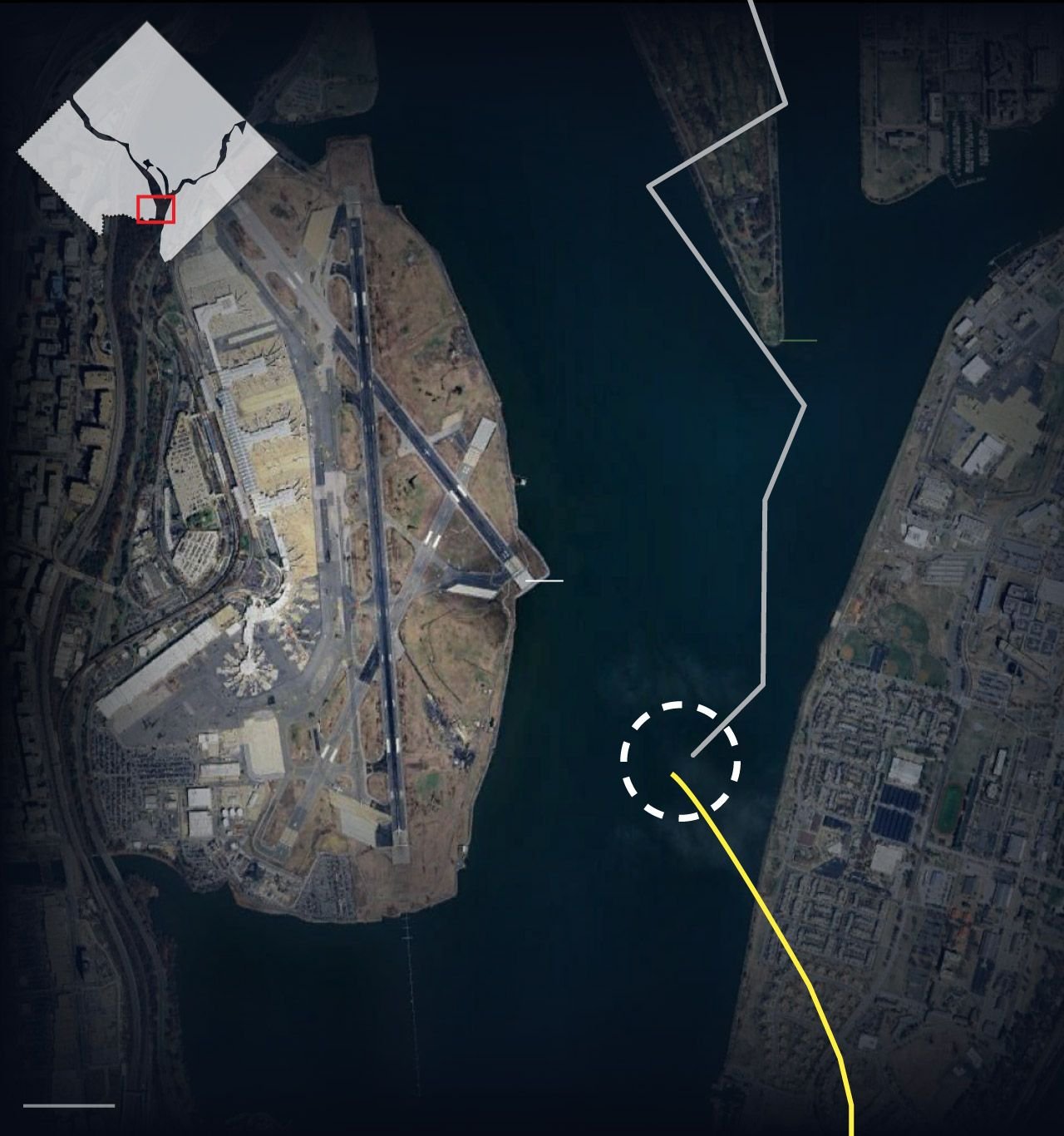
The golf course is on a peninsula in the river, so the helicopter was flying over water before and after it made the two turns.
Subjects
ATC
DCA
Radar
Route 4
Links are to this post in the relevant subject page so that this post can be seen in context.
Reply to this quoting this original post. You need to be logged in. Not available on closed threads.
January 30, 2025, 14:32:00 GMT
permalink Post: 11817282
You could contact them if you want and tell them it\x92s wrong. No offense intended.
Even if it wasn\x92t a sharp turn, it was done over a golf course and their flight path was probably dictated by noise abatement reasons, as are those flown by jets flying into DCA.
Subjects
ATC
DCA
Radar
Route 4
Links are to this post in the relevant subject page so that this post can be seen in context.
Reply to this quoting this original post. You need to be logged in. Not available on closed threads.