February 05, 2025, 08:11:00 GMT
permalink Post: 11821971
As a previous poster has said, they are using third world procedures at what is a very busy and high-density traffic area. I doubt if this collision would have occurred in many other countries as positive separation and/or significant restrictions are provided to ALL aircraft, be they IFR or VFR, and certainly not at night.
I suspect however that the DoD would not be too happy with not being able to operate VFR. h.
Subjects
FAA
IFR
Separation (ALL)
VFR
Links are to this post in the relevant subject page so that this post can be seen in context.
Reply to this quoting this original post. You need to be logged in. Not available on closed threads.
February 06, 2025, 13:32:00 GMT
permalink Post: 11822989
Again, not excusing things, not saying it can’t improve, but the size of the problem is huge. Ultimately, the solution is less aviation. I’ve flown all over the world, nowhere has the traffic the US has. ATL, for example has a mix of traffic unheard of in Europe. I’ve been in the bizjets, airliners, I’ve seen jet fighters parked there and a Piper Cherokee on the GA ramp. Same in LAX, DFW, LGA, BOS. We do not expect the restrictions on aviation acceptable elsewhere and we have plenty of it.
Our GA safety record is pretty awful, but at glance it’s probably 75% of the world’s total GA flying. It’s also no accident to see FAA-registered GA planes in the EU. Guess why?
Subjects
FAA
TCAS (All)
TCAS RA
Links are to this post in the relevant subject page so that this post can be seen in context.
Reply to this quoting this original post. You need to be logged in. Not available on closed threads.
February 07, 2025, 00:09:00 GMT
permalink Post: 11823328
Did the FAA or the Army assume they would always be able to apply visual (NOT VFR) separation. Visual separation does not necessarily mean 500\x92 vertically and 1.5 nm or radar target separation; it means \x93I see you, I miss you\x94. Did the operating plan always direct crews to use visual separation as the default plan? I hope not, but it is only I see it being written.
Subjects
FAA
IFR
Radar
Route 4
Separation (ALL)
VFR
Visual Separation
Links are to this post in the relevant subject page so that this post can be seen in context.
Reply to this quoting this original post. You need to be logged in. Not available on closed threads.
February 07, 2025, 19:13:00 GMT
permalink Post: 11823870
Subjects
ATC
FAA
Separation (ALL)
Visual Separation
Links are to this post in the relevant subject page so that this post can be seen in context.
Reply to this quoting this original post. You need to be logged in. Not available on closed threads.
February 07, 2025, 21:23:00 GMT
permalink Post: 11823937
https://www.faa.gov/documentLibrary/...5-24_READY.pdf
As mentioned upthread, if not visually separated then either 500ft or 1.5mi applies.
Correct if this is all wrong, but in the accident sequence if the helo had responded ‘not visual yet, looking’ or words to that effect, then presumably a controller could allow the two to get a bit closer and then advise the conflicting traffic info to the helo again, say at 2.5mi. If helo visual, great —maintain visual separation, responsibly passes to helo.
This is what happened, although the very busy controller failed to re-state the position of the CRJ to direct the eyes of the helo crew onto the CRJ in order that they could actually see and avoid it.
However if not visual at say 2.5mi, well it’s a bit late, but the controller does still retain responsibility for separation and must apply the 500ft/1.5mi standard. Presumably instant vectors away while simultaneously climb to min vectoring altitude. Or the CRJ has to go around. Can of worms in busy airspace— helos and /or jets being dispersed all over the sky.
Much better to do a rules based system and mutually exclude intersecting IFR app/deps and Helo Visual Routes.
Last edited by Stagformation; 7th February 2025 at 22:06 .
Subjects
ATC
CRJ
FAA
IFR
See and Avoid
Separation (ALL)
Visual Separation
Links are to this post in the relevant subject page so that this post can be seen in context.
Reply to this quoting this original post. You need to be logged in. Not available on closed threads.
February 07, 2025, 21:37:00 GMT
permalink Post: 11823944
This is following on from #960-964, discussing what would happen if the PAT flight(s) refused visual separation. It seems like it would throw a spanner in ATC's arrivals and they would probably get a response similar to that Lufthansa A380: Buzz off somewhere else.
Subjects
ATC
FAA
Radar
Separation (ALL)
Visual Separation
Links are to this post in the relevant subject page so that this post can be seen in context.
Reply to this quoting this original post. You need to be logged in. Not available on closed threads.
February 09, 2025, 18:15:00 GMT
permalink Post: 11825063
To discuss what he could or should have done is just playing " Captain hindsight "
The procedure was wrong , the safety case botched , and as I understand, the " book " allowing all this was followed by both the controller and the helicopter pilot .
Let's discuss the procedures and visual separation delegation at night in busy airports instead on focusing on what the controller should have done , implying indirectly some form of responsibility in this accident..
cf FAA Order JO 7110.65AA 7.2.1.a.2 Pilot-applied visual separation
(e)Advise the pilots if the radar targets appear likely to merge.
Last edited by deltafox44; 9th February 2025 at 19:04 . Reason: adding source
Subjects
ATC
FAA
Pass Behind
Pass Behind (All)
Radar
Separation (ALL)
Visual Separation
Links are to this post in the relevant subject page so that this post can be seen in context.
Reply to this quoting this original post. You need to be logged in. Not available on closed threads.
February 09, 2025, 21:03:00 GMT
permalink Post: 11825124
cf FAA Order JO 7110.65AA 7.2.1.a.2 Pilot-applied visual separation
Subjects
ATC
FAA
Separation (ALL)
Situational Awareness
Visual Separation
Links are to this post in the relevant subject page so that this post can be seen in context.
Reply to this quoting this original post. You need to be logged in. Not available on closed threads.
February 11, 2025, 06:13:00 GMT
permalink Post: 11825867
On the other hand the collision will have somewhat altered trajectory of both aircraft, so maybe the collision had still occured over land and due to the lateral energy transfer the Helicopter was thrown off its original course towards the West and into the river. We will get this information finally.
And in the end it doesn't really make that much of a difference wrt the level of lunacy of this whole setup.
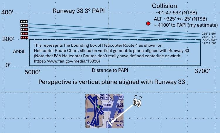
Collision Altitude vs PAPI
Last edited by airplanecrazy; 11th February 2025 at 06:30 . Reason: Problem with picture. Awkward phrasing
Subjects
ADSB (All)
Blackhawk (H-60)
FAA
NTSB
Links are to this post in the relevant subject page so that this post can be seen in context.
Reply to this quoting this original post. You need to be logged in. Not available on closed threads.
February 11, 2025, 19:28:00 GMT
permalink Post: 11826281
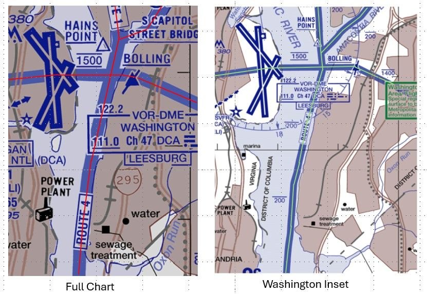
DCA Helicopter Routes
Given these chart differences, I wonder how far a helicopter can stray from the various depictions of a route before it is considered a pilot deviation? Perhaps the NTSB will give us some insight with their accident report.
Last edited by airplanecrazy; 14th February 2025 at 23:53 . Reason: Emphasize the route "appear"
Subjects
DCA
FAA
NTSB
PAT25
Route 4
Separation (ALL)
Visual Separation
Links are to this post in the relevant subject page so that this post can be seen in context.
Reply to this quoting this original post. You need to be logged in. Not available on closed threads.
February 11, 2025, 22:31:00 GMT
permalink Post: 11826358
DCA Helicopter Routes
Given these chart differences, I wonder how far a helicopter can stray from the various depictions of a route before it is considered a pilot deviation? Perhaps the NTSB will give us some insight with their accident report.
"...FAA depicted width of a helicopter route is governed by the following doc: https://www.faa.gov/air_traffic/flight_info/aeronav/iac/media/IAC15/IAC-15-22AUG2022-complete.pdf "
I think that the "width" that you are referring is for the chart maker but not the actual width of a helicopter route.
I can't find in any FAA document a definition of the lateral extent of a helicopter route. Is there one?
There are inconsistencies between the "DESCRIPTION OF ROUTES AND ALTITUDES" and the charts themselves. The Merriam-Webster's 11th Collegiate Dictionary definition of "BANK 2 : the rising ground bordering a lake, river, or sea or forming the edge of a cut or hollow."
for example "RT. 4: ... VIA EAST BANK OF POTOMAC RIVER..." while the chart depicts RT. 4 over the POTOMAC RIVER not over the ground bordering the river.
while "RT. 15: ... ALONG THE WESTERN SHORE OF THE CHESAPEAKE BAY AND PATAPSCO RIVER..." and the chart depicts RT. 15 over water.
Last edited by airman1900; 11th February 2025 at 22:33 . Reason: punctuation and quote
Subjects
DCA
FAA
NTSB
Links are to this post in the relevant subject page so that this post can be seen in context.
Reply to this quoting this original post. You need to be logged in. Not available on closed threads.
February 12, 2025, 16:42:00 GMT
permalink Post: 11826805
I am sorry you see a witch hunt in my post. It was supposed to be an idea for a future improvement, rather than a criticism of the very hard worked man who was on the job. On the flying end, there is quite a rigid procedure to follow if a TCAS RA goes off. From posts since I see, that there seems to be one for for STCA triggers too. It seems to me that the gravity of the situation is brought faster to a pilot's attention if the Conflict warning is announced on the RT.
That is just one factor in this sad affair of course. Both TCAS and STCA are last ditch saviours but only if full attention can be paid to them.
Now on the Conflict alert on the BRITE display . I have no first hand info on the SOPs in DCA on how a TWR controller uses the BRITE and if STCA are even displayed . `, but if they are, seen the charts and the routes , I guess STCA alerts are very common .especially when you delegate separation and you then play with a couple of hundred feet, vertical separation Too many unnecessary alerts equals normalization of deviance, . Look at the Haneda preliminary report , same ..
Finally since you mention TCAS RAs , there is a major difference with STCA , it is not the same as a TCAS RA . With an RA , as a pilot you have to react and follow , it is mandatory , for a controller a STCA is just an alert , just like a TCAS TA , if in your judgement it will pass you will not do anything , and if you have already issued a correcting instruction ( heading, level , etc,,) or here delegate visual separation , the STCA just becomes a nuisance. .
I sincerely hope the DC Controller will not be made the scapegoat of this accident . Not so sure it will not.
Subjects
ATC
DCA
FAA
NTSB
Normalization of Deviance
Preliminary Report
Separation (ALL)
TCAS (All)
TCAS RA
Vertical Separation
Visual Separation
Links are to this post in the relevant subject page so that this post can be seen in context.
Reply to this quoting this original post. You need to be logged in. Not available on closed threads.
February 12, 2025, 19:46:00 GMT
permalink Post: 11826918
Now on the Conflict alert on the BRITE display . I have no first hand info on the SOPs in DCA on how a TWR controller uses the BRITE and if STCA are even displayed . `, but if they are, seen the charts and the routes , I guess STCA alerts are very common .especially when you delegate separation and you then play with a couple of hundred feet, vertical separation Too many unnecessary alerts equals normalization of deviance, . Look at the Haneda preliminary report , same ..
Finally since you mention TCAS RAs , there is a major difference with STCA , it is not the same as a TCAS RA . With an RA , as a pilot you have to react and follow , it is mandatory , for a controller a STCA is just an alert , just like a TCAS TA , if in your judgement it will pass you will not do anything , and if you have already issued a correcting instruction ( heading, level , etc,,) or here delegate visual separation , the STCA just becomes a nuisance. .
I sincerely hope the DC Controller will not be made the scapegoat of this accident . Not so sure it will not.
Rarely does the "bad apple" theory of accident causation survive the scrutiny of a robust, honest investigation.
Last edited by Senior Pilot; 12th February 2025 at 23:14 . Reason: Quote was unreadable
Subjects
ATC
DCA
FAA
NTSB
Normalization of Deviance
Preliminary Report
Separation (ALL)
TCAS (All)
TCAS RA
Vertical Separation
Visual Separation
Links are to this post in the relevant subject page so that this post can be seen in context.
Reply to this quoting this original post. You need to be logged in. Not available on closed threads.
February 13, 2025, 00:47:00 GMT
permalink Post: 11827075
__________
Federal air-safety officials want to permanently keep helicopters away from commercial jets taking off and landing at a busy Washington, D.C., airport after the deadliest U.S. aviation accident in more than two decades.
The move, under consideration by senior Federal Aviation Administration officials, would be part of a long-term plan to improve safety at Ronald Reagan Washington National Airport, according to people familiar with the discussions.
Helicopters have been temporarily barred from flying in a corridor used by the U.S. Army Black Hawk that collided on Jan. 29 with an American Airlines regional jet, killing 67 people. The chopper routes have been used to ferry senior military officials around the region and to train for a \x93continuity of government\x94 mission in the event American political leaders need rapid evacuation from Washington. Other government agencies have also used the routes.
Federal officials have said they would revisit the helicopter restrictions once the National Transportation Safety Board issues a preliminary report on the accident in the coming weeks. Preliminary indications from the probe point to multiple factors potentially contributing to the crash, including the design of the airspace, as well as actions by the helicopter pilot and air-traffic controller, according to people familiar with the investigation.
The NTSB said it would examine how far apart planes and helicopters are supposed to be while flying in the airspace.
Transportation Secretary Sean Duffy has criticized the Pentagon\x92s operation of helicopters near the airport. \x93If we have generals who are flying in helicopters for convenience through this airspace, that\x92s unacceptable,\x94 he said last week. \x93Get in a damn Suburban and drive. You don\x92t need to take a helicopter.\x94
The Army said it would continue to comply with FAA requirements and restrictions to enhance flight safety. The service said it was reassessing its aircraft operations near the airport and that it gave priority to the safety of the public and military personnel. The current restrictions allow certain critical flights.
Duffy also suggested certain military missions can be done at a different time of night. The Jan. 29 crash occurred around 9 p.m. Eastern time.
Defense officials have assumed that the helicopter routes would be closed in the coming months amid several ongoing investigations, but have privately said that the routes should be reopened. Adjustments under consideration if routes are reopened include limiting hours for training and test missions.
Reagan\x92s convenient location, a few miles from Capitol Hill, has made the nearly 84-year-old airport a favorite among politicians, business executives and tourists.
Space is tight at the airport. Reagan\x92s longest runway, Runway 1, is the nation\x92s busiest, airport officials have said, and it has two smaller runways. Routes into and out of the airport are constrained by no-fly zones around sensitive government buildings.
The FAA has said it is also reviewing airspace around airports aside from Reagan that also have high volumes of helicopter and airplane traffic.
Discussions about Reagan airport have also focused on a small runway known as Runway 33, people familiar with the matter said. The American Airlines regional jet was attempting to land there when it collided with the Army helicopter. Some government and industry aviation officials believe that there isn\x92t a problem with planes using the runway if helicopters aren\x92t near the traffic lanes.
Warning signs existed for years about risks facing commercial passengers, with planes sharing the skies closely with helicopters zipping up and down the Potomac River.
The path the American Airlines regional jet took toward Runway 33 required it to turn toward the right and then bank left to line up for its landing. That route crosses over a lane for helicopters at a relatively low altitude.
There have been at least 35 events involving conflicts between helicopters and flights into and out of the airport that have been flagged since the 1980s, according to a Wall Street Journal analysis of anonymous reports to a system overseen by the National Aeronautics and Space Administration.
In one instance, in July 2018, a helicopter and small plane came within roughly 580 feet of each other while the plane was approaching Runway 33. The helicopter pilot had to maneuver to avoid the plane and questioned the air-traffic controller about it after, according to an internal FAA report on the incident viewed by the Journal.
Neither aircraft had received traffic advisories or safety alerts, the report said. The helicopter pilot reported the incident as a near midair collision. \x93I\x92m sorry for the confusion,\x94 the controller told the helicopter pilot, according to an audio recording of air-traffic-control communications following the incident.
Nearly two weeks after the deadly crash over the Potomac, the FAA has lifted some of the constraints put on Reagan airport in the wake of the accident.
The FAA on Tuesday boosted the airport\x92s arrival rate from 26 to 28 aircraft an hour, after temporarily reducing it to ease the strain on controllers still dealing with the aftermath of the crash, according to an email viewed by the Journal and earlier reported by other news outlets. The current rate is still lower than the airport\x92s typical maximum of 32 arrivals an hour.
Reagan\x92s two smaller runways, which had been closed due to search and recovery efforts, have been reopened.
________
Subjects
ATC
Blackhawk (H-60)
DCA
FAA
NTSB
Preliminary Report
Wall Street Journal
Links are to this post in the relevant subject page so that this post can be seen in context.
Reply to this quoting this original post. You need to be logged in. Not available on closed threads.
February 13, 2025, 22:16:00 GMT
permalink Post: 11827672
ATC do a fantastic job of managing the flow, basically by issuing helicopter traffic clearance limits based on the VRPs - usually based on Thames bridges. The Eastbound clearance limit is usually the Isle of Dogs\x85. Before London City Tower take over to manage traffic closer to the airport. At the Western end the heli routes go nowhere near the LHR approaches due or traffic density.
ATC will not in my experience clear any helicopter traffic to visually proceed behind airline traffic based on the helicopters visual perception. Day or night. They do a great job of keeping both airline and rotary traffic advised about each other, and prioritise air ambulance and police helicopters as required. But, they keep control over the overall traffic flow and it works.
I just fail to see why the FAA couldn\x92t employ a similar system, where helicopter traffic is issued a clearance limit - pending a gap in traffic - either a natural one or an ATC created gap. Before being cleared to continue.
I have also been in the situation having started engines at London City and police helicopter then was tasked to something going on off the departure end of the runway. All departures and arrivals suspend. Indefinite delays. It\x92s part of the bigger picture. CAVOK day but no possibility of visual separation. So the London system gives priority to helicopters where appropriate. But seems infinitely safer for both airline and helicopter traffic.
Subjects
ATC
FAA
Separation (ALL)
Visual Separation
Links are to this post in the relevant subject page so that this post can be seen in context.
Reply to this quoting this original post. You need to be logged in. Not available on closed threads.
February 14, 2025, 23:38:00 GMT
permalink Post: 11828295
I think that the "width" that you are referring is for the chart maker but not the actual width of a helicopter route.
I can't find in any FAA document a definition of the lateral extent of a helicopter route. Is there one?
Subjects
FAA
Route 4
Links are to this post in the relevant subject page so that this post can be seen in context.
Reply to this quoting this original post. You need to be logged in. Not available on closed threads.
February 15, 2025, 01:45:00 GMT
permalink Post: 11828334
"RT. 4: FORT WASHINGTON OVER POTOMAC RIVER TO WILSON BRIDGE. THEN VIA EAST BANK
OF POTOMAC RIVER TO ANACOSTIA RIVER. INTERCEPT ROUTE 1 AT ANACOSTIA RIVER.
ALTITUDES: AT OR BELOW 1000 FEET MSL AT FORT WASHINGTON, DESCEND TO 600 FEET
MSL ABEAM BROAD CREEK INLET, BEGIN DESCENT FROM 600 FEET MSL TO
ARRIVE AT 300 FEET MSL OVER WILSON BRIDGE, THEN AT OR BELOW 200 FEET MSL NORTH
OF WILSON BRIDGE.
It would seem to me that "OVER POTOMAC RIVER" and "VIA EAST BANK OF POTOMAC RIVER" would indicate some sort of "boundary."
I think that this Helicopter Route Chart is poorly done and would like to know how the FAA designates helicopter routes and who designs these charts.
In my opinion the New York Special Flight Rules Area charting and text On the New York Terminal Area Chart is done much better.
Last edited by airman1900; 15th February 2025 at 01:51 . Reason: added text
Subjects
FAA
Route 4
Links are to this post in the relevant subject page so that this post can be seen in context.
Reply to this quoting this original post. You need to be logged in. Not available on closed threads.
February 15, 2025, 12:41:00 GMT
permalink Post: 11828596
Why did the did miss part of the message
Why was the incomplete read back missed
Why does missing a few words lead to this disaster within seconds.
Does this lead an answer like: helicopter in a very busy airspace, busy controllers (insufficient time to be fully focused on full read backs) being by default too close to (and even needing to cross) the glideslope.
Helicopters in busy airspace are not a problem if a safe system exists for separating them from airline traffic.
There is no evidence yet of the controller having made a mistake. He was undoubtedly busy, but that was not his fault. What could be done about it? The answers to that question take us another step along the causal chain:
- The FAA could have provided more controllers. We know the helicopter controller position was unoccupied, and it's likely that closer monitoring and earlier intervention could have changed the outcome (notwithstanding point 3).
- Controller workload could have been reduced by implementing effective procedural separation . If the DCA ATC rulebook allowed this segment of Route 4 to be in simultaneous use with Runway 33 landings, then procedural separation did not exist , however much anyone thought it did. At least 1.5nm or 500ft between flight paths would be needed to meet the least restrictive FAA separation standards, and this would have forced constraints to be applied to Route 4 or Runway 33 utilisation.
- Regulations allowed the helo pilots to assume responsibility for separation. This is what happened, with the consequences which flow from the inherent difficulty of identifying and separating visually at night (especially while wearing NVG).
The authorities (by which I mean FAA and DoD) have questions to answer on all three points. Why was the helicopter controller position vacant? Did the ATC rulebook or staffing requirements rely on a false assumption that procedural separation existed? How did any such assumption remain in place after previous near misses? Is visual separation between helicopters and airline traffic a reasonable thing for regulations to permit, at night and using NVG? Ultimately it seems to have routinely been used as a release valve for the pressure building in the system due to the failure to address points 1 and 2.
Hopefully the investigation will be bold enough to ask these questions, which expand the potential scope of responsibility well beyond the individual controller and pilots.
Last edited by Easy Street; 15th February 2025 at 13:36 .
Subjects
ATC
Close Calls
DCA
FAA
Night Vision Goggles (NVG)
Route 4
Separation (ALL)
Visual Separation
Links are to this post in the relevant subject page so that this post can be seen in context.
Reply to this quoting this original post. You need to be logged in. Not available on closed threads.
February 16, 2025, 04:57:00 GMT
permalink Post: 11828979
Now on the Conflict alert on the BRITE display . I have no first hand info on the SOPs in DCA on how a TWR controller uses the BRITE and if STCA are even displayed . `, but if they are, seen the charts and the routes , I guess STCA alerts are very common .especially when you delegate separation and you then play with a couple of hundred feet, vertical separation Too many unnecessary alerts equals normalization of deviance, . Look at the Haneda preliminary report , same ..
Finally since you mention TCAS RAs , there is a major difference with STCA , it is not the same as a TCAS RA . With an RA , as a pilot you have to react and follow , it is mandatory , for a controller a STCA is just an alert , just like a TCAS TA , if in your judgement it will pass you will not do anything , and if you have already issued a correcting instruction ( heading, level , etc,,) or here delegate visual separation , the STCA just becomes a nuisance. .
I sincerely hope the DC Controller will not be made the scapegoat of this accident . Not so sure it will not.
In the US, physicians who work for "Health Maintenance Organizations" are asked to practice medicine, at times, in a "basically unsafe" manner...to keep patients moving. On occasion, such practices will bite a patient (and sometimes the physician). As a whole, HMO physicians do not enjoy the best reputation.
From my perspective, there is practically no difference between the plight of an American air traffic controller and an American HMO physician. Both are expected to "squeeze one more in." Both fields are staffed by above-average capable individuals who thrive on challenges. Both are managed in such a manner that they cannot say "no" and also keep their job. In this regard, at least physicians have job portability.
But the take home point is that one cannot admit to knowing a practice is fundamentally unsafe, yet do it anyway. The public, rightfully, should not accept this. I have no solution except more staff and/or more airports (and not some next-gen whizzbang computer system).
Subjects
ATC
DCA
FAA
NTSB
Normalization of Deviance
Preliminary Report
Separation (ALL)
TCAS (All)
TCAS RA
Vertical Separation
Visual Separation
Links are to this post in the relevant subject page so that this post can be seen in context.
Reply to this quoting this original post. You need to be logged in. Not available on closed threads.
February 16, 2025, 18:30:00 GMT
permalink Post: 11829380
200 feet is the maximum and they had to get permission for this route. They\x92re flying past a busy airport. On one hand you\x92re all saying this accident was bound to happen, on the other hand this in and of itself indicates pilots don\x92t fly through these zones without concerns & vigilance. It makes no sense they would play roulette with the height - most pilots would be adhering to rules & a little on edge knowing a VIP or any number of emergency protocols could happen in the capital of America.
It just doesn\x92t add up - the complacency over elevation. Between two pilots it should have been rectified. May they rest in peace & this isn\x92t a slur against their name but in support of it not being their fault and something amiss.
Systems that rely on human perfection are 100% guaranteed to fail. The only question is how often. The system in place at DCA required helo pilots to assume responsibility for visual (*not vertical*) avoidance of collisions in order to fulfil their ordered missions. Given what we know about human visual performance at night, that would eventually end badly, and sure enough it did. There is a strong element of the pilots having been set up to fail, which is why no-one here is going hard on them.
Altimetry and height keeping would be important matters for investigators if the collision had occurred due to a breakdown in vertical separation, which as a minimum would involve 500 feet (and more often 1000 feet) of planned spacing to account for instrument and height keeping errors. FAA instrument rating standards require pilots to be able to maintain altitude plus or minus 100 feet. This helicopter was being flown VFR at very low height, which means that looking outside takes primacy over monitoring instruments. I'm sure helo pilots could fly along at 175ft plus or minus 25ft if they really tried, but you can be certain they wouldn't be looking out for traffic (as is required when holding responsibility for visual separation).
However, as there was no vertical separation built into this procedure, all of this is at best a distraction. The more important questions are why procedural barriers were not in place to stop the route being used during landings on runway 33, and whether visual separation at night is an adequate barrier to collision when airliners and their human cargo are involved.
Last edited by Easy Street; 16th February 2025 at 18:57 .
Subjects
CRJ
DCA
FAA
PAT25
Separation (ALL)
VFR
Vertical Separation
Visual Separation
Links are to this post in the relevant subject page so that this post can be seen in context.
Reply to this quoting this original post. You need to be logged in. Not available on closed threads.