January 30, 2025, 02:58:00 GMT
permalink Post: 11816794
Subjects
Blackhawk (H-60)
Links are to this post in the relevant subject page so that this post can be seen in context.
Reply to this quoting this original post. You need to be logged in. Not available on closed threads.
January 30, 2025, 03:55:00 GMT
permalink Post: 11816832

Subjects: None
No recorded likes for this post (could be before pprune supported 'likes').Reply to this quoting this original post. You need to be logged in. Not available on closed threads.
January 30, 2025, 04:09:00 GMT
permalink Post: 11816845

Subjects: None
No recorded likes for this post (could be before pprune supported 'likes').Reply to this quoting this original post. You need to be logged in. Not available on closed threads.
January 30, 2025, 05:24:00 GMT
permalink Post: 11816893
Subjects
NBC
Links are to this post in the relevant subject page so that this post can be seen in context.
Reply to this quoting this original post. You need to be logged in. Not available on closed threads.
January 30, 2025, 11:37:00 GMT
permalink Post: 11817142
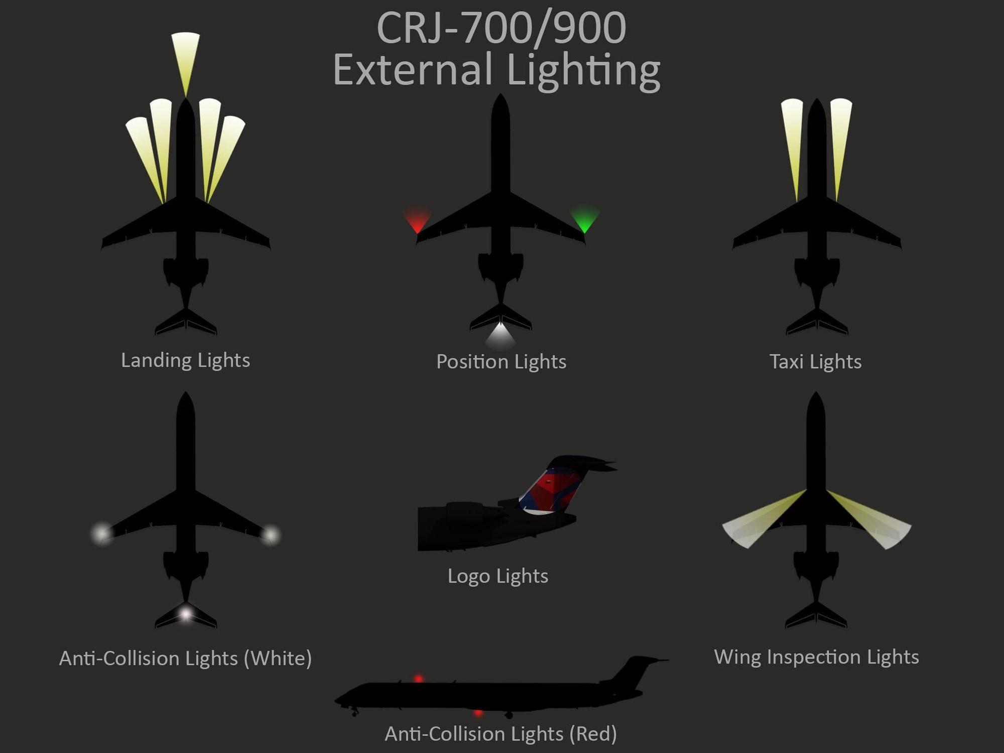
External Lighting
Landing Lights
Subjects: None
No recorded likes for this post (could be before pprune supported 'likes').Reply to this quoting this original post. You need to be logged in. Not available on closed threads.
January 30, 2025, 12:40:00 GMT
permalink Post: 11817196
Subjects: None
4 recorded likes for this post.Reply to this quoting this original post. You need to be logged in. Not available on closed threads.
January 30, 2025, 13:20:00 GMT
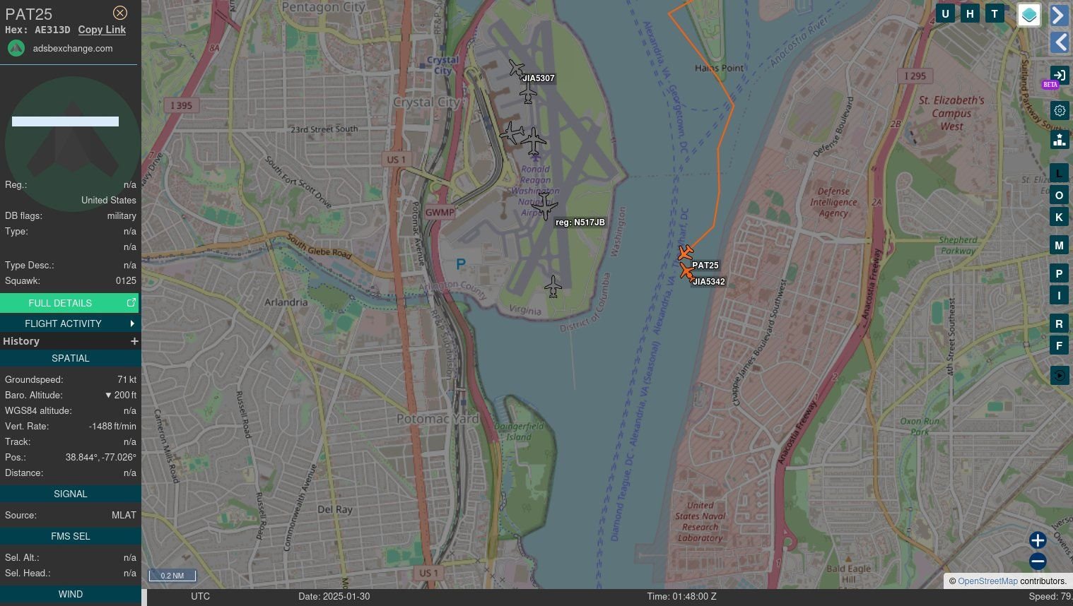
permalink Post: 11817228
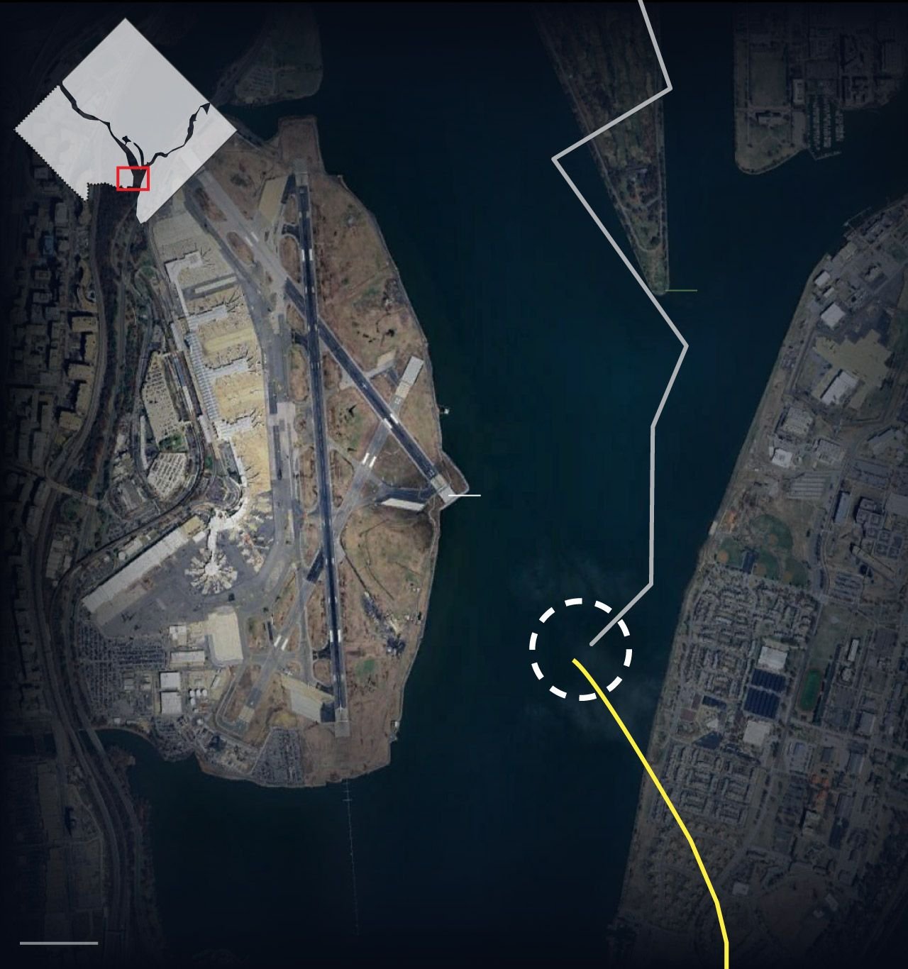
Or could the circling approach from 01 to 33 also be a factor with the helo misinterpreting the CRJ flight path and somehow losing sight ? The track of both aircraft is interesting… helo seems to initially be parallel to the river bank and turns 40 right. Why ? Was their destination the same airport or was that manoeuvre related to traffic avoidance or loss of visual ?
All guesswork I know… putting Special VFR traffic so close to final approach traffic at night clearly a problem. Tragic.
The golf course is on a peninsula in the river, so the helicopter was flying over water before and after it made the two turns.
Subjects
CRJ
Circle to Land (Deviate to RWY 33)
VFR
Links are to this post in the relevant subject page so that this post can be seen in context.
Reply to this quoting this original post. You need to be logged in. Not available on closed threads.
January 30, 2025, 14:10:00 GMT
permalink Post: 11817272
The golf course is on a peninsula in the river, so the helicopter was flying over water before and after it made the two turns.
Subjects
ATC
DCA
Radar
Route 4
Links are to this post in the relevant subject page so that this post can be seen in context.
Reply to this quoting this original post. You need to be logged in. Not available on closed threads.
January 30, 2025, 17:54:00 GMT
permalink Post: 11817466
Hanging the ATCO on duty will not bring back the dead, and was not the cause of the problem. Having a civil aircraft flight path immediately overhead a LL RW VFR transit lane that guarantees that there is a loss of separation standards is what set this off, and that has been the case for decades. The crews, pax, ATC officers and families just happened to be the ones that got caught out by the insanity that permitted this track and procedure to exist.
Will Mr T go after the ATC guy? probably, the ATC officer doesn't own a kingdom, a corporation, in fact he is highly unlikely to have a DUI, and certainly won't be a convicted felon. So, I would rate the ATC guy as the convenient fall guy for the US Govt, the FAA who should not have permitted the operation of civil aircraft proximate to military LL traffic, and the US DOD, who will have signed off on the practice of disregarding minimum separation per \xa791.111. As far as right of way, the CRJ was landing, \xa791.113(g) applies, notwithstanding 91.113(d). The CRJ had every reasonable expectation of not sharing a cockpit on short finals to a short runway with crossing helo traffic.
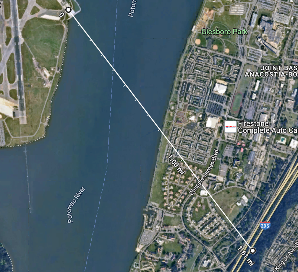
- IDTEK is 1.4nm from touchdown, 490' PA
- the east bank of the river is half way to the runway, ~0.7nm, -> 245'+40' = 285'PA
- the collision occurred around mid river, ~0.3-0.4nm from T/D, or 125+40=165'
What is particularly annoying is that the generals and other command staff, and Secretaries of Transport, Defence etc are quite happy to cashier the F-18 pilots who do a slow flypast of an arena, or the T-38 instructors who do the same over some other game, and yet, what is the chance that any general takes responsibility for their part in this sorry state of affairs. responsibility like other stuff, only goes downwards,
Its pretty easy for the guy in charge to defame the ATCO.
Glass houses.
Subjects
ATC
ATCO
CRJ
FAA
Normalization of Deviance
President Donald Trump
Separation (ALL)
VFR
Links are to this post in the relevant subject page so that this post can be seen in context.
Reply to this quoting this original post. You need to be logged in. Not available on closed threads.
January 31, 2025, 14:49:00 GMT
permalink Post: 11818266
It is genuinely odd how they flew directly into this thing which must literally have been lighting up the interior of their cockpit. Also, why were they above the 200ft route ceiling?
(Still from the video referenced above by ORAC.)

Helo on the left
Subjects
CRJ
Links are to this post in the relevant subject page so that this post can be seen in context.
Reply to this quoting this original post. You need to be logged in. Not available on closed threads.
January 31, 2025, 15:35:00 GMT
permalink Post: 11818296
It is genuinely odd how they flew directly into this thing which must literally have been lighting up the interior of their cockpit. Also, why were they above the 200ft route ceiling?
(Still from the video referenced above by ORAC.)
Helo on the left
The other lights should have been visible from inside the helicopter, but they were likely looking a different direction to monitor other aircraft.
Subjects
CRJ
Links are to this post in the relevant subject page so that this post can be seen in context.
Reply to this quoting this original post. You need to be logged in. Not available on closed threads.
January 31, 2025, 15:43:00 GMT
permalink Post: 11818303
You're suggesting that the civilian ATC controller was talking to the helo on UHF and separately talking to the civ traffic on VHF?
Because it's clearly the same controller voice. What's the published UHF frequency for the civ traffic controller to use?
His first video had responses from the helo, just not all of them... The civ ATC is sending to the helo on VHF and receiving on UHF? Is that mentioned anywhere on the VAS Aviation channel? Because the LiveATC recordings page has clips which include all the audio with no mention of splices being made.
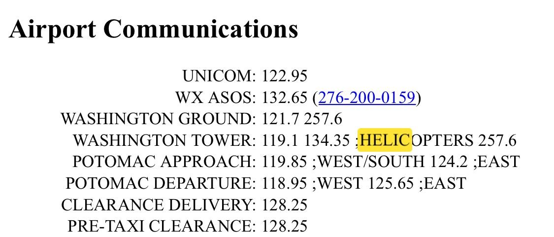
This isn\x92t UHF; just a different VHF frequency.
Subjects
ATC
Links are to this post in the relevant subject page so that this post can be seen in context.
Reply to this quoting this original post. You need to be logged in. Not available on closed threads.
January 31, 2025, 16:26:00 GMT
permalink Post: 11818343
Was there a change to the definition of VHF and UHF that we didn't get the memo on?
Our own versions of the 60 have needs for VHF along with FM, UHF and HF, secure or not. Presumably the USA doesn't use an ICOM A23 or similar when dropping in to some towns local airstrip. ARC-231"s? using a UHF freq when mixing with civil traffic would be self limiting, presumably the tapes will indicate the helo was on VHF freq not the UHF one.
Subjects: None
2 recorded likes for this post.Reply to this quoting this original post. You need to be logged in. Not available on closed threads.
January 31, 2025, 16:38:00 GMT
permalink Post: 11818348
It is genuinely odd how they flew directly into this thing which must literally have been lighting up the interior of their cockpit. Also, why were they above the 200ft route ceiling?
(Still from the video referenced above by ORAC.)
Helo on the left
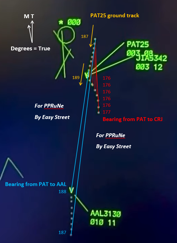
Here's the more likely issue with NVG. Looking through them is often described as akin to looking through a pair of toilet roll tubes. Field of vision is radically reduced and it takes strong, conscious and fatiguing effort to conduct any kind of visual search.
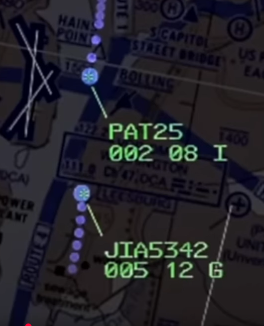
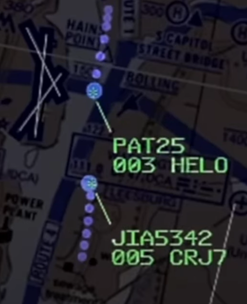
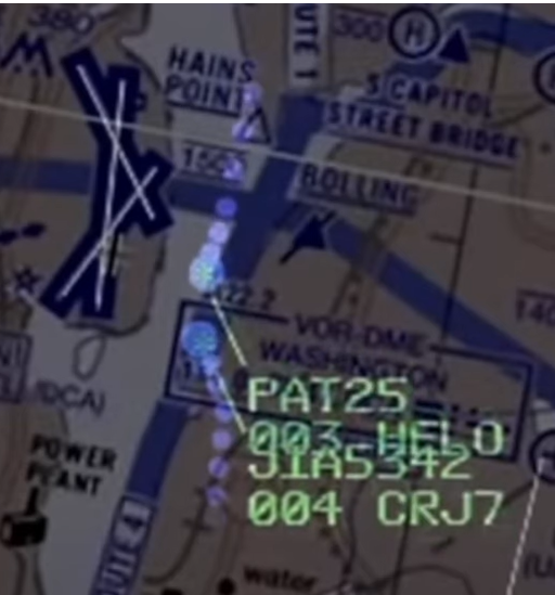
At the start of the radar recording posted to YouTube by AvHerald, AAL3130 is 10 degrees right of the CRJ from PAT25's point of view, and at a similar elevation angle. Its landing lights would be prominent in NVG and if PAT25's pilots were fixated upon it, they would not have seen the CRJ further left unless actively moving their heads to look for it. PAT25 gradually changes heading by 2 degrees right during the course of the radar clip, almost exactly following the bearing to AAL3130, and this makes it even clearer to me that PAT25 was mistakenly holding visual on it.
Last edited by Easy Street; 31st January 2025 at 16:50 .
Subjects
CRJ
Night Vision Goggles (NVG)
PAT25
Radar
Links are to this post in the relevant subject page so that this post can be seen in context.
Reply to this quoting this original post. You need to be logged in. Not available on closed threads.
January 31, 2025, 16:52:00 GMT
permalink Post: 11818357
Here's the more likely issue with NVG. Looking through them is often described as akin to looking through a pair of toilet roll tubes. Field of vision is radically reduced and it takes strong, conscious and fatiguing effort to conduct any kind of visual search.
At the start of the radar recording posted to YouTube by AvHerald, AAL3130 is 10 degrees right of the CRJ from PAT25's point of view, and at a similar elevation angle. Its landing lights would be prominent in NVG and if PAT25's pilots were fixated upon it, they would not have seen the CRJ further left unless actively moving their heads to look for it. PAT25 gradually changes heading by 2 degrees right during the course of the radar clip, almost exactly following the bearing to AAL3130, and this makes it even clearer to me that PAT25 was mistakenly holding visual on it.
Subjects
CRJ
Night Vision Goggles (NVG)
PAT25
Radar
Links are to this post in the relevant subject page so that this post can be seen in context.
Reply to this quoting this original post. You need to be logged in. Not available on closed threads.
January 31, 2025, 20:43:00 GMT
permalink Post: 11818517
It is genuinely odd how they flew directly into this thing which must literally have been lighting up the interior of their cockpit. Also, why were they above the 200ft route ceiling?
(Still from the video referenced above by ORAC.)
Helo on the left
I have ZERO doubt that either crew had a slightest idea of what was about to happen. I can fill 30 minutes explaining my next 10 seconds but suffice to say, a complete surprise. “WTF was that” will be the short version.
Subjects
CRJ
Findings
Separation (ALL)
Visual Separation
Links are to this post in the relevant subject page so that this post can be seen in context.
Reply to this quoting this original post. You need to be logged in. Not available on closed threads.
February 01, 2025, 11:44:00 GMT
permalink Post: 11818956
Have to ask, why the use of goggles in basically night CAVOK and a densely light city area.
Last edited by megan; 1st February 2025 at 11:54 .
Subjects
Radar
Links are to this post in the relevant subject page so that this post can be seen in context.
Reply to this quoting this original post. You need to be logged in. Not available on closed threads.
February 01, 2025, 16:56:00 GMT
permalink Post: 11819164
Subjects
ATC
Radar
Separation (ALL)
Vertical Separation
Links are to this post in the relevant subject page so that this post can be seen in context.
Reply to this quoting this original post. You need to be logged in. Not available on closed threads.
February 01, 2025, 17:18:00 GMT
permalink Post: 11819178
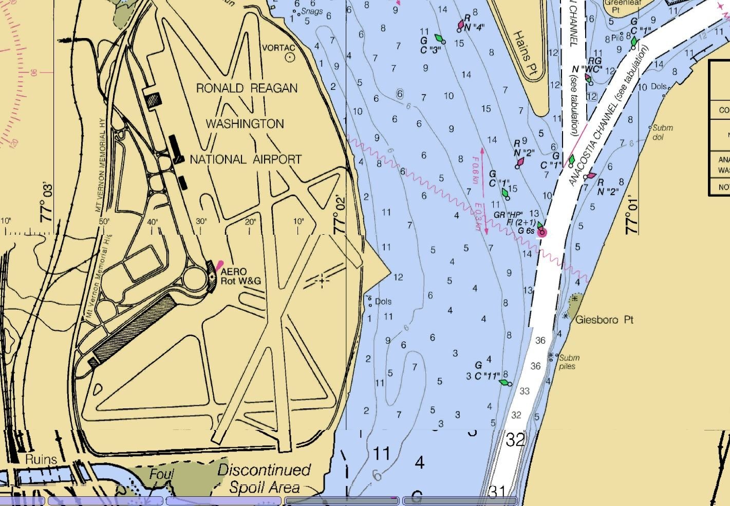
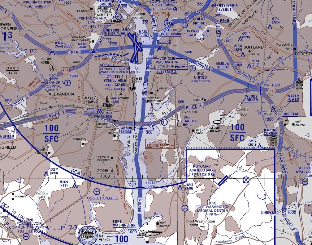
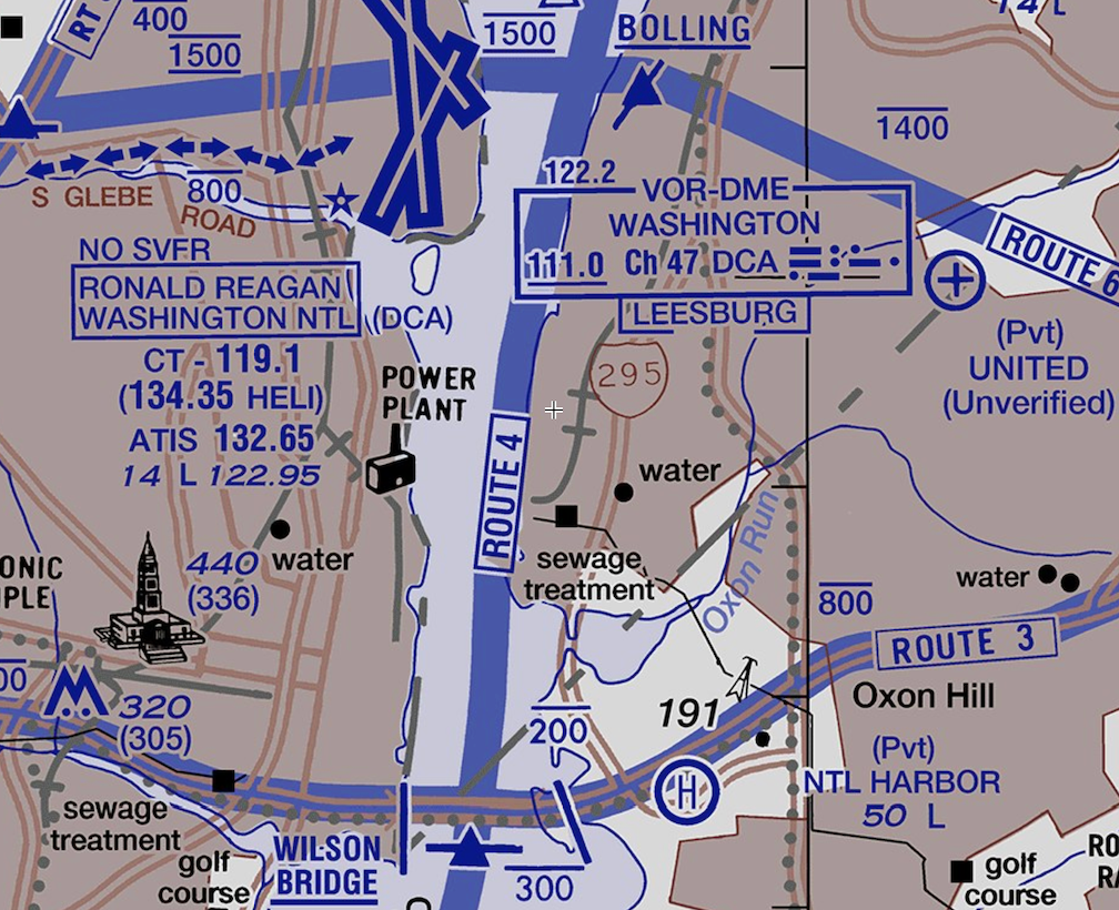
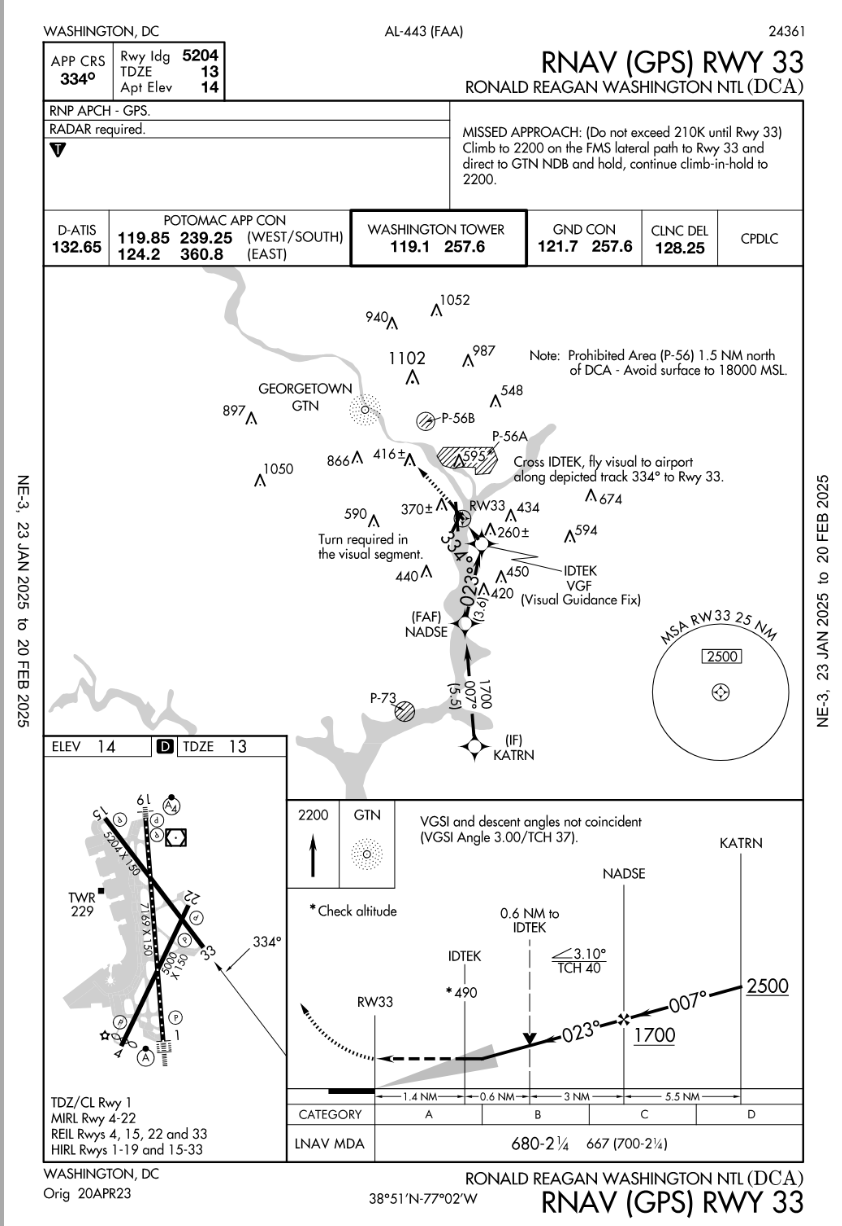
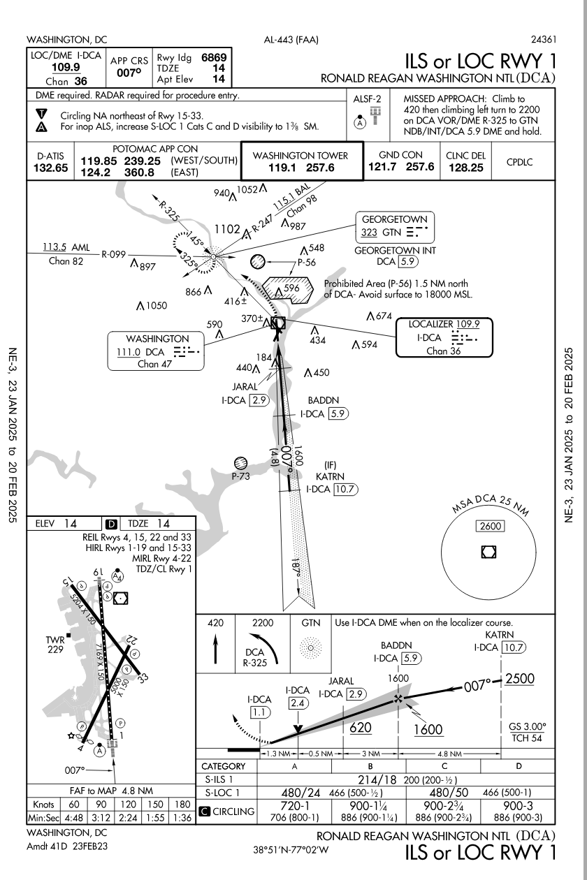
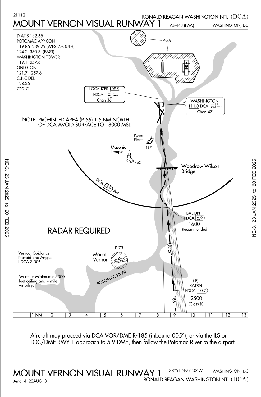
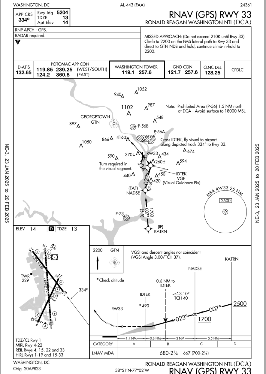
There is a curving RNAV approach, that is not in line with the runway until 490 feet/1.4nm, where one makes the last-minute ~50\xb0 left turn for visual runway alignment.
In light of that fact, maybe you can reframe your question.
AirNav: KDCA - Ronald Reagan Washington National Airport
https://aeronav.faa.gov/d-tpp/2501/00443R33.PDF
Now a test question for him.... . were you flying the incident airplane doing a Visual Approach to RWY33....would you have tuned up the IAP for that RWY as an additional reference for your approach ?
SOP's usually instruct Crews to use ILS data when doing Visual Approaches to runways with that kind of IAP so would that kind of thinking apply in this incident? Would that have been of any benefit considering the existing weather and terrain? Or, would that have been a distraction?
Pattern, perhaps you might review your comment.
It really is not a difficult concept or question.
Seems easy enough to understand if the post is actually read for comprehension sakes.
About 80% of all IATA operators would be discomforted by such changes, outside of the USA visual approaches at night have a litany of requirements to adhere to for the purposes of terrain separation, vs Texas big sky rules that do work in the US. In the end, taht didn't cause the accident, it is one of those things that goes with the freedom of flight in the USA.
...
Subjects
ATC
CRJ
KDCA
Separation (ALL)
Links are to this post in the relevant subject page so that this post can be seen in context.
Reply to this quoting this original post. You need to be logged in. Not available on closed threads.
February 01, 2025, 18:07:00 GMT
permalink Post: 11819203
My thoughts:
I continue to see this as:
- a failure of imagination by command;
- a system failure by command to monitor performance against expected system behaviour;
- an information system failure, the evidence has been in front of those that are charged with having safe systems such as the govt, regulator, DOD, airlines;
- The crew and the the ATC controller, and certainly the passengers are not high in the systemic failures that occur here, I would contend that the crew and the ATC officer are victims of the systemic failures.
Criss-Crossing Routes in D.C. Airspace Leave Little Room for Error
By Elena Shao , Leanne Abraham , Eli Murray and Lazaro GamioThe pictures are out of order, the tracks are for "1-Week" of data. The latest NOTAM is a good start, the helo fleet operators may want to revisit the concept of the flyways.
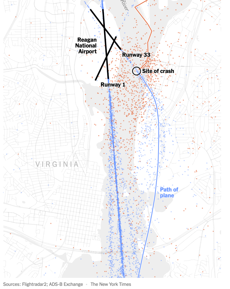
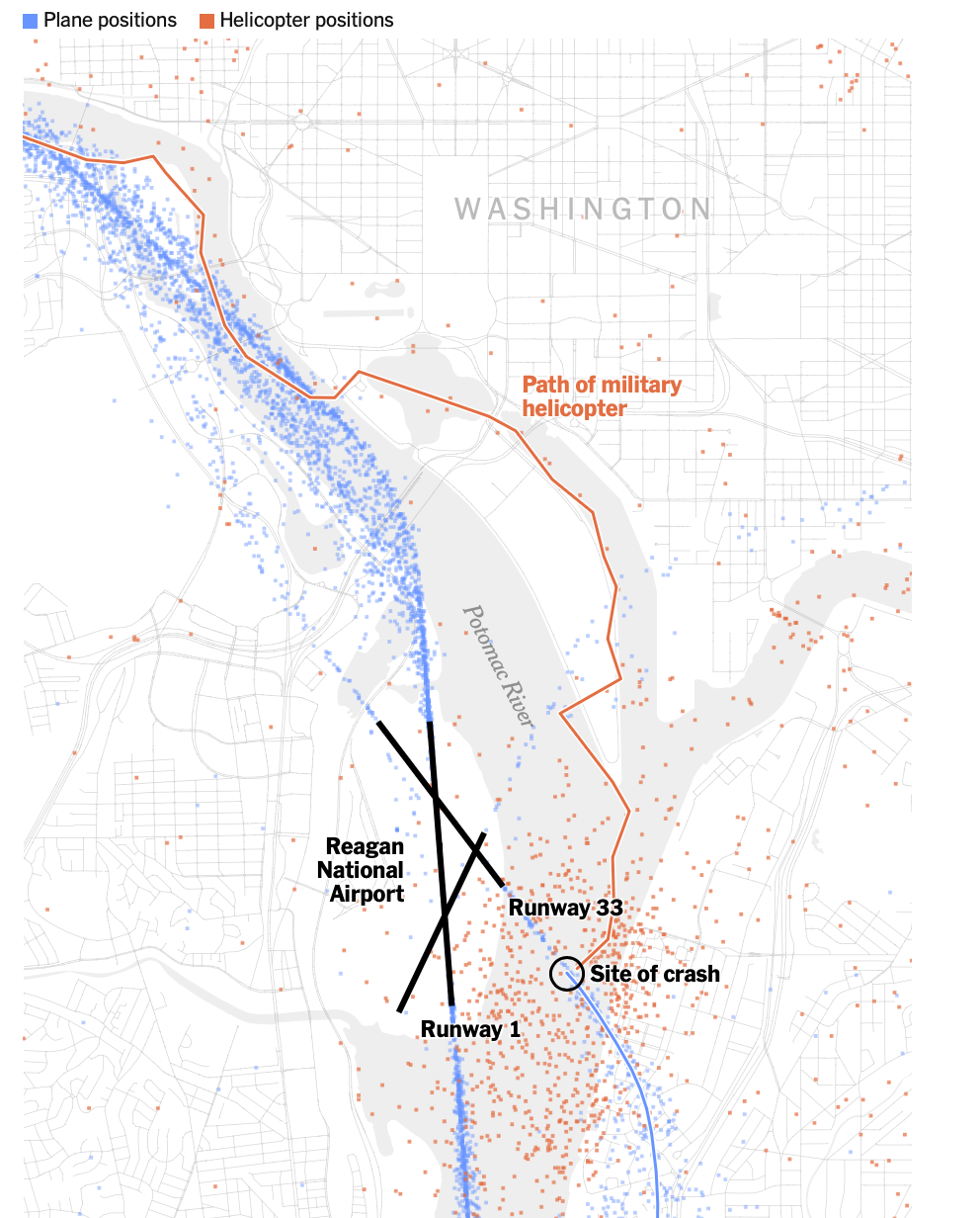
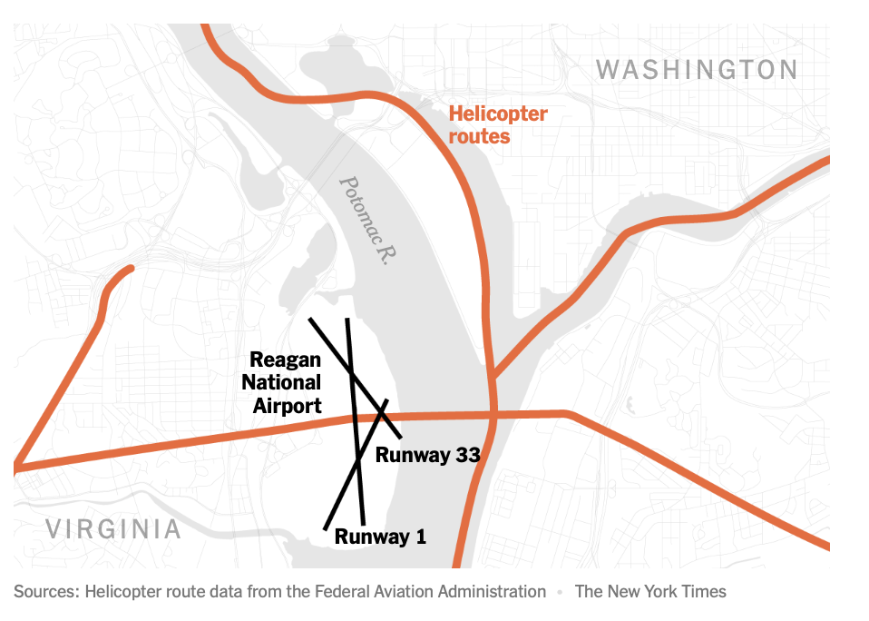
A deadly midair collision between an American Airlines passenger jet and a U.S. Army helicopter near Ronald Reagan National Airport in Washington highlights the complexity of navigating an airspace with many civilian and military aircraft.
The airport has three runways that intersect, but only one is used for nearly all of its hundreds of daily flights. With the routes of aircraft routinely criss-crossing one another, there is little room for error as planes descend onto the runways. To stay out of the way of commercial jets, helicopters in this area are supposed to fly along a route designated by the Federal Aviation Administration at an altitude no higher than 200 feet.
Air traffic data from the past week shows that helicopters flying along the Potomac River must navigate amid the takeoffs and landings of hundreds of planes daily. While they are advised by the F.A.A. to stick to a tight air corridor above the eastern bank of the river, data shows that in reality, helicopters can be spotted across the width of the river.
One week of air traffic at Reagan National
Dots show positions of planes during their takeoffs and landings at Reagan National Airport, as well as the positions of helicopters as they traversed the area from Jan. 23 to Jan. 30.The American Airlines flight was cleared to land on Runway 1 before being instructed by an air traffic controller shortly before the collision to pivot its landing route to the intersecting Runway 33.
The last-minute request to switch runways at Reagan National is “very common,” said Shawn Pruchnicki, a former airline pilot and an assistant professor at the Center for Aviation Studies at Ohio State University, who said he has piloted aircraft into the airport more than a hundred times.
Skies were clear on Wednesday night when the two aircraft collided. But, in case of low visibility, like in poor weather, the F.A.A. has designed “instrument approaches,” or descents that involve a series of steps pilots must follow to maneuver down to the runway safely.
The instrument approach for Runway 1 calls for a descending plane to cross over the helicopter corridor while the plane is at a much higher altitude, somewhere from 620 to 1,700 feet and more than a minute from landing. The approach for Runway 33, however, calls for a plane to cross over the helicopter corridor at a much lower altitude, because a plane is seconds from landing. The clearance between a helicopter in the corridor and a descending plane may be from 100 to 300 feet, which can result in close calls if there are severe fluctuations in the altitude of either aircraft.
Sources: Helicopter route and instrument approach data from the Federal Aviation Administration
Note: An instrument approach is a descent that involves a series of scripted flight maneuvers, with pilots using navigation aids and instruments to reach the runway safely when visibility is low, such as in poor weather.
The [failing] New York Times
Given the clear nighttime weather, the plane’s pilots would not have been expected to initiate an instrument approach to aid their landing, Mr. Pruchnicki said, and instead could have used their vision to guide their descent to the runway. Data on the aircraft’s positions indicates that the pilots’ route was very similar to the one outlined in an instrument approach. For example, the plane maintained roughly the recommended altitude when it made a leftward turn toward Runway 33.
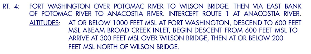
In this case, the Army Black Hawk requested permission to use the route designated for helicopters, meaning that it would keep to the eastern bank of the Potomac and stay under 200 feet in altitude. But the helicopter was at least a half-mile off of the approved route when it collided with the jet, according to four people briefed on the matter but not authorized to speak publicly. The helicopter was also flying above 300 feet, not below 200, the people said.
The crash also renewed questions about the safety of intersecting runways, which the F.A.A. has sought to eliminate or close in recent years in places like Chicago and Dallas because of concerns over congestion on the ground. The setup can increase the workload of the air traffic controller, especially if the two runways are getting used simultaneously for takeoff and landing, said Cyriel Kronenburg, a former air traffic controller and pilot.
An internal preliminary report from the F.A.A., which was reviewed by The New York Times , said that a supervisor allowed an air traffic controller to leave early, sometime before the crash. This left one air traffic controller to manage the dual roles of handling helicopters in the airport’s vicinity and also instructing planes that were landing and departing from runways, according to a person briefed on the matter. While it is within the supervisor’s discretion to combine the duties, that staffing configuration “was not normal for the time of day and volume of traffic,” the F.A.A. report said.
A Times investigation in 2023 found that the nation’s air traffic control facilities are chronically understaffed , contributing to an alarming number of close calls in the skies and on the runways across the country. Before the plane crash on Wednesday night, there were at least 10 close calls at Reagan National in the last three years that were documented in government records reviewed by The Times.
Additional research by Riley Mellen.
See more on: Federal Aviation Administration (F.A.A.)
https://www.nytimes.com/interactive/...smid=url-share
Subjects
ATC
Blackhawk (H-60)
Close Calls
FAA
Preliminary Report
Links are to this post in the relevant subject page so that this post can be seen in context.
Reply to this quoting this original post. You need to be logged in. Not available on closed threads.