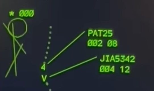
February 01, 2025, 18:47:00 GMT
permalink Post: 11819231
Subjects
Radar
Links are to this post in the relevant subject page so that this post can be seen in context.
Reply to this quoting this original post. You need to be logged in. Not available on closed threads.
February 01, 2025, 21:52:00 GMT
permalink Post: 11819330
From the 'Mil' thread:
Subjects
ADSB (All)
CRJ
TCAS (All)
TCAS RA
Links are to this post in the relevant subject page so that this post can be seen in context.
Reply to this quoting this original post. You need to be logged in. Not available on closed threads.
February 02, 2025, 18:46:00 GMT
permalink Post: 11819999
In relation to your earlier response to my previous comment, how can the system tell someone to 'remain level' when that aircraft doesn't have TCAS? I am not sure of the Blackhawk fit, but I would be pretty surprised if it has TCAS fitted.
One of the main reasons that TCAS alerts are inhibited at low altitude is to avoid distraction during the landing phase, in an area that has a high traffic density and a high probably of nuisance alerts. The system would constantly be giving RAs and people would be going around and deviating all over the place. Even if just TAs were left active then it would be going off all the time, and we would be having the same conversation about becoming blase to the warnings as we are about the repetitive conflict alerts that were being given to the LC.
Getting TCAS to give RAs on final is not the solution in my opinion.
Subjects
ADSB (All)
Blackhawk (H-60)
TCAS (All)
TCAS RA
Links are to this post in the relevant subject page so that this post can be seen in context.
Reply to this quoting this original post. You need to be logged in. Not available on closed threads.
February 03, 2025, 01:52:00 GMT
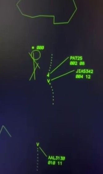
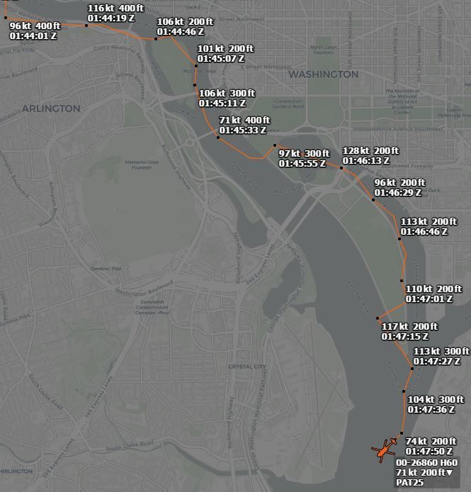
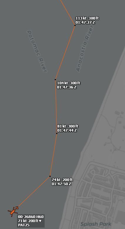
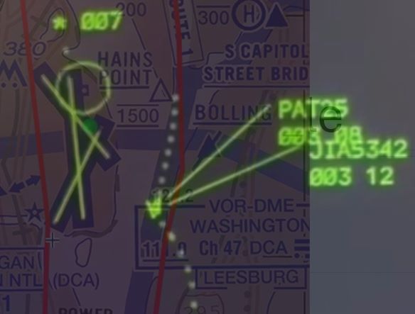
permalink Post: 11820222
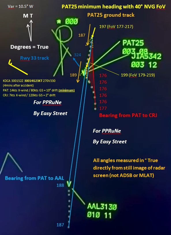
My marked up version of the radar plot now shows the heading of PAT25 at the first and penultimate sweep, based on the ground track as measured directly from the plot and assuming that the wind is at the non-gust value from the METAR observation taken just 4 minutes later (making this a reasonable minimum drift). It also shows the 40 degree field of view of the AN/AVS-9 NVG, drawn assuming both pilots are looking directly ahead along aircraft centreline.
The take-away is that with these assumptions, the CRJ starts on the extreme left hand edge of the NVG field of view and then moves just out of it. The PAT25 pilots would only see the CRJ in NVG if they turned their heads left of aircraft centreline to search for it. Since they thought they had visual contact, presumably with AAL3130, they would have no reason to do so.
Subjects
CRJ
Night Vision Goggles (NVG)
PAT25
Radar
Links are to this post in the relevant subject page so that this post can be seen in context.
Reply to this quoting this original post. You need to be logged in. Not available on closed threads.
February 03, 2025, 06:44:00 GMT
permalink Post: 11820286
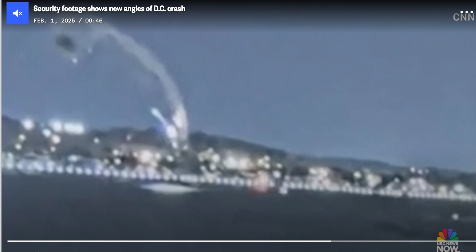
It's at about 31 seconds into this video
Subjects
Blackhawk (H-60)
NBC
Links are to this post in the relevant subject page so that this post can be seen in context.
Reply to this quoting this original post. You need to be logged in. Not available on closed threads.
February 03, 2025, 21:26:00 GMT
permalink Post: 11820910
Last edited by spornrad; 3rd February 2025 at 23:06 .
Subjects
CRJ
Circle to Land (Deviate to RWY 33)
Pass Behind
Pass Behind (All)
Links are to this post in the relevant subject page so that this post can be seen in context.
Reply to this quoting this original post. You need to be logged in. Not available on closed threads.
February 03, 2025, 22:46:00 GMT
permalink Post: 11820975
No crossing of 'Route 4' prior to ...
Subjects
CRJ
Circle to Land (Deviate to RWY 33)
Pass Behind
Pass Behind (All)
Route 4
Links are to this post in the relevant subject page so that this post can be seen in context.
Reply to this quoting this original post. You need to be logged in. Not available on closed threads.
February 03, 2025, 23:29:00 GMT
permalink Post: 11821012
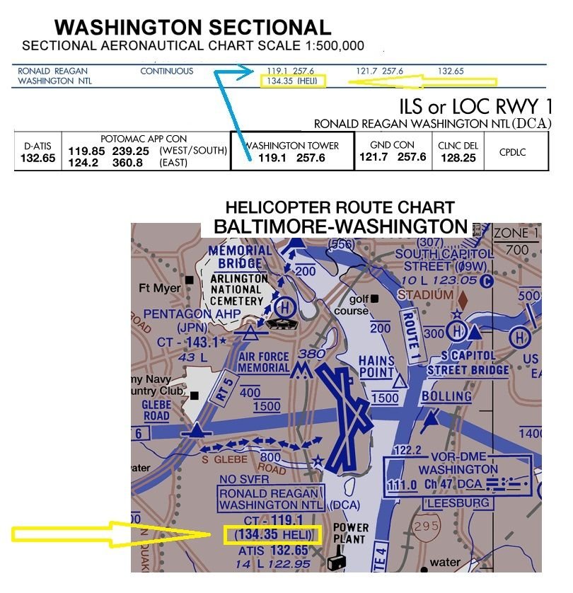
But for those rebuking any mentioning of a VHF Heli frequency, please provide some proof as any reference I find on VFR sectionals, is a VHF Heli-frequency.
IFR charts only have the regular VHF+UHF TWR freq.
Subjects
IFR
VFR
Links are to this post in the relevant subject page so that this post can be seen in context.
Reply to this quoting this original post. You need to be logged in. Not available on closed threads.
February 03, 2025, 23:43:00 GMT
permalink Post: 11821022
I agree that these are just guesses, but the alternative seems to be that the helo just drifted to the right randomly, for no specific reason, which seems unlikely.
Subjects
CRJ
Radar
Route 4
Separation (ALL)
Links are to this post in the relevant subject page so that this post can be seen in context.
Reply to this quoting this original post. You need to be logged in. Not available on closed threads.
February 04, 2025, 00:35:00 GMT
permalink Post: 11821049
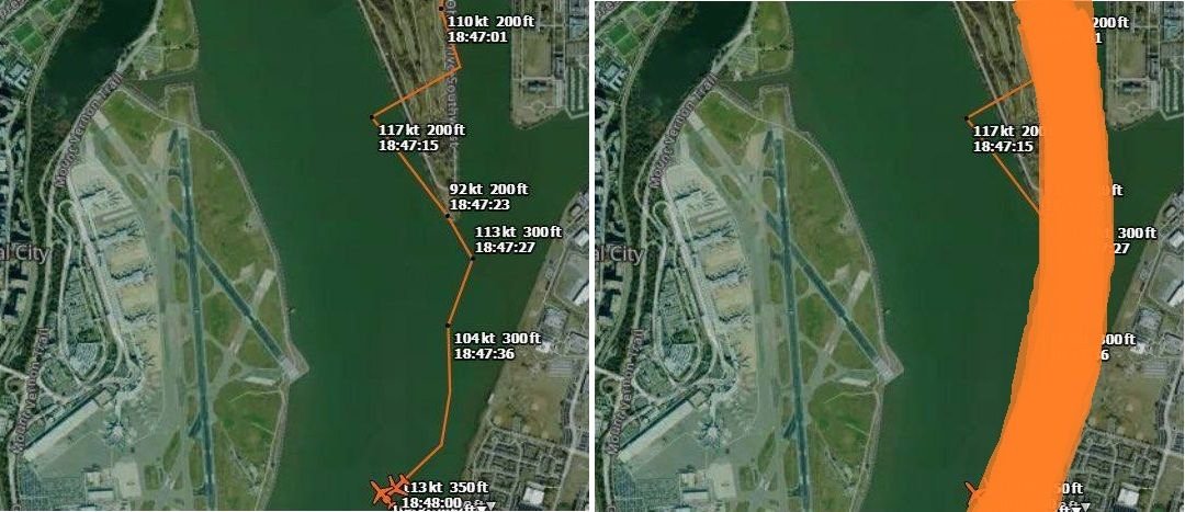
And the "amateur MLAT" tracking of the helo, is only a rough indication of the trajectory with a wide margin of position error and should be interpreted more like the right side hereunder:
Subjects
CRJ
KDCA
Radar
Route 4
Links are to this post in the relevant subject page so that this post can be seen in context.
Reply to this quoting this original post. You need to be logged in. Not available on closed threads.
February 04, 2025, 01:19:00 GMT
permalink Post: 11821070

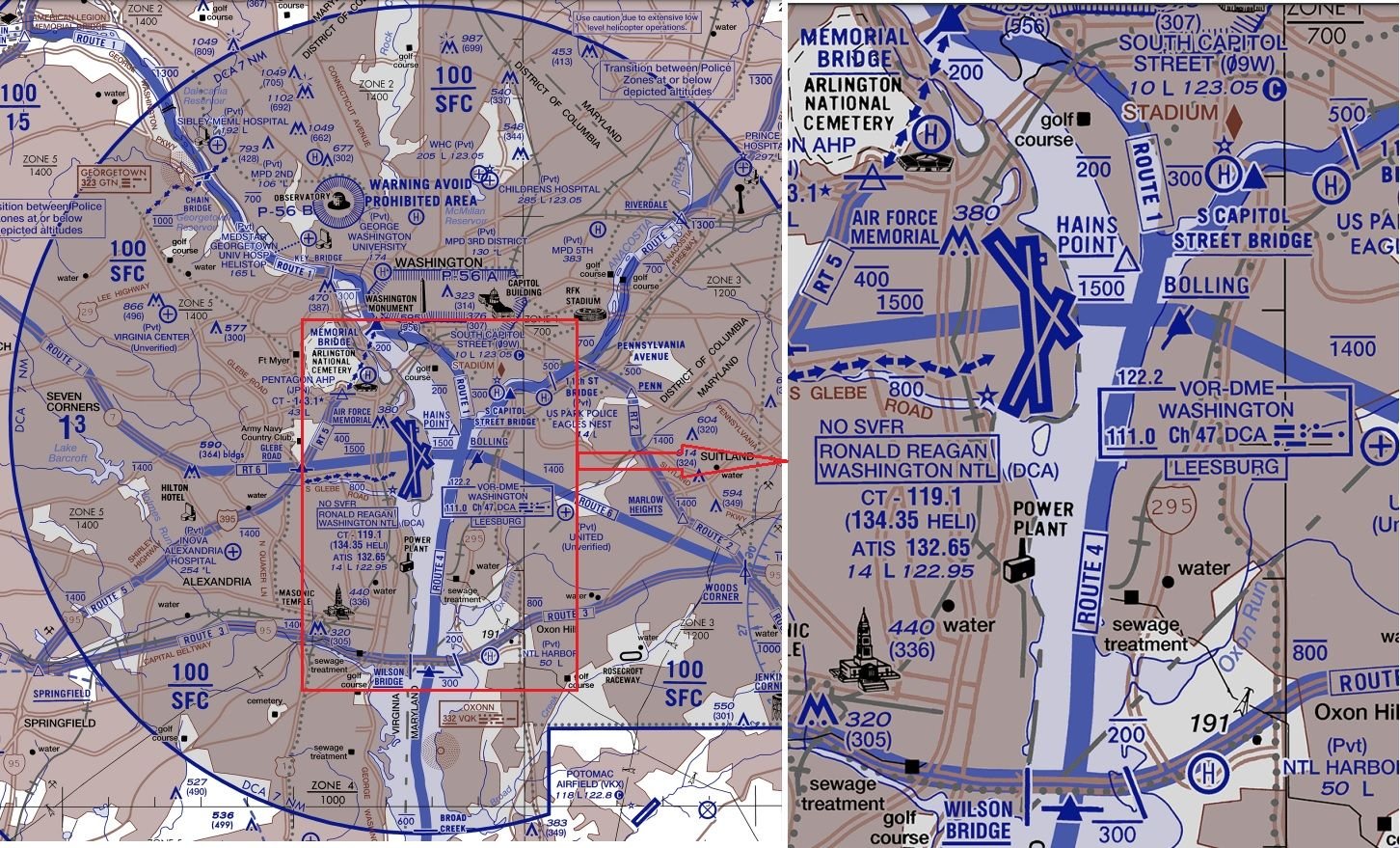
And yeah, with the route overlayed on the radar, the deviation from the route doesn't seem to be that great, since the route itself also turns right.
Subjects
Radar
Links are to this post in the relevant subject page so that this post can be seen in context.
Reply to this quoting this original post. You need to be logged in. Not available on closed threads.
February 04, 2025, 21:40:00 GMT
permalink Post: 11821727
Subjects: None
No recorded likes for this post (could be before pprune supported 'likes').Reply to this quoting this original post. You need to be logged in. Not available on closed threads.
February 04, 2025, 22:48:00 GMT
permalink Post: 11821767
to put "all the way" into context, 18 seconds is what they had
Subjects
ADSB (All)
NTSB
TCAS (All)
Links are to this post in the relevant subject page so that this post can be seen in context.
Reply to this quoting this original post. You need to be logged in. Not available on closed threads.
February 04, 2025, 23:36:00 GMT
permalink Post: 11821805
Subjects
Radar
Links are to this post in the relevant subject page so that this post can be seen in context.
Reply to this quoting this original post. You need to be logged in. Not available on closed threads.
February 04, 2025, 23:53:00 GMT
permalink Post: 11821816
Subjects
Radar
Links are to this post in the relevant subject page so that this post can be seen in context.
Reply to this quoting this original post. You need to be logged in. Not available on closed threads.
February 05, 2025, 00:05:00 GMT
permalink Post: 11821822
I think the confusion comes from the "amateur MLAT" tracking, which calculates the GS based on the multilaterated position calculations, which have a (relatively) large margin of error:
And probably PAT25 was doing initially something in the region of 100kts GS (edit: averaging all but last calculated GS, gives 105kts as average - and over more datapoints, longer trajectory, calculated average GS becomes more reliable)
but at the end it seems there might possibly have been a decreasing GS trend:
Last edited by DIBO; 5th February 2025 at 00:10 . Reason: added calculated average GS
Subjects
ADSB (All)
CRJ
PAT25
Radar
Links are to this post in the relevant subject page so that this post can be seen in context.
Reply to this quoting this original post. You need to be logged in. Not available on closed threads.
February 05, 2025, 11:21:00 GMT
permalink Post: 11822123
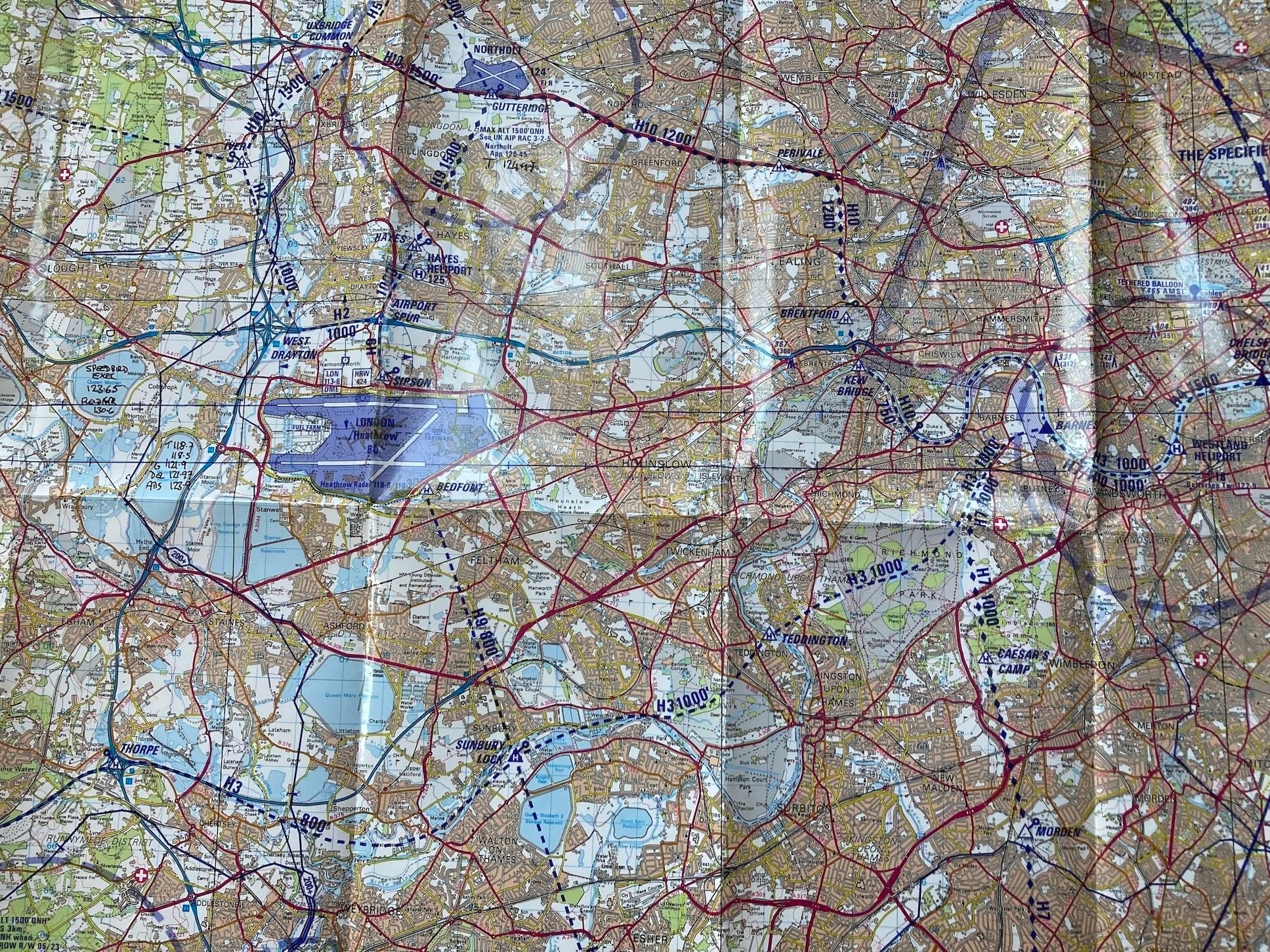
Usually, only if crossing LHR you'd be cleared to enter via requested route with limit Bedfont/Sipson, sometimes Airport Spur to hold (orbit) and change from Heathrow Special to Tower for the crossing itself. There's a further hold at Twin Taxiways between the runways. Altitudes are shown. Note there is usually unrestricted passage on routes H3 and H10 along the river directly under the approach. This system works seamlessly and with - to date - total safety.
Accepted the aairport we are discussing has more varied runway directions than Heathrow so the situation would be a bit more complex but I can't see why a similar system couldn't be devised - with defined clearance limits, sensible vertical separation and, critically, coherent and specific controller voice procedure.
There's no reason not to make landing traffic aware of helos holding close in if appropriate and indeed that happens, but no way is their visual contact required.
The entire system operates on visual 'separation'. Helos cross visually behind traffic as cleared, but with vertical separation. It's as safe as the system can be made. How else could it work? It requires no controller vectoring and the time and space margins that would be required if radar separation was used would render the slick, efficient visual system cumbrous, unacceptably high end unnecessary workload and probably unworkable.
Please, once again let's stop applying this insular f/w procedural IFR mindset to VFR helo traffic. There seems to be a procedural IFR mental blockage that can't see that 'visual separation' occurs in three dimensions, not just two. Helos are perfectly capable of ensuring visual separation as long as the traffic has been correctly identified and with vertical separation as here even if a mistake is made there is 800ft clear vertically. Also, VFR does NOT mean, as many seem to imagine, blundering about randomly at will, it is often every bit as disciplined and controlled as IFR as Shackman reiterates below, these routes are rigidly enforced to within a hundred metres or so and woe betide the transgressor.
The elephant in the room here is a combintion of a ridiculously hazardous two-dimensional crossing procedure combined with culpably sloppy & imprecise r/t which offers no second slice of cheese, not matters of visual separation. I'm well aware that our transatlantic cousins are sensitive to criticism of their relaxed, easygoing and informal ways in the air but in this case they self-evidently were the direct cause of 70 odd deaths. While they may regard European style as excessively pedantic there's no doubt whatsoever that had European standards applied here this event would have resulted in nothing more serious than a MOR and an Airmiss report.
For those unfamiliar the light grid squares are 1Km so the Sipson and Bedfont reporting/holding points is ony about 500m from the runways.
Last edited by meleagertoo; 5th February 2025 at 12:23 .
Subjects
ATC
IFR
Radar
Separation (ALL)
VFR
Vertical Separation
Visual Separation
Links are to this post in the relevant subject page so that this post can be seen in context.
Reply to this quoting this original post. You need to be logged in. Not available on closed threads.
February 05, 2025, 19:16:00 GMT
permalink Post: 11822469
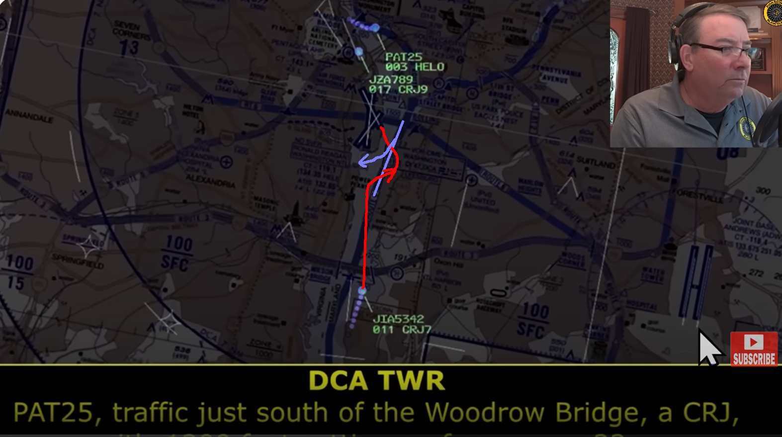
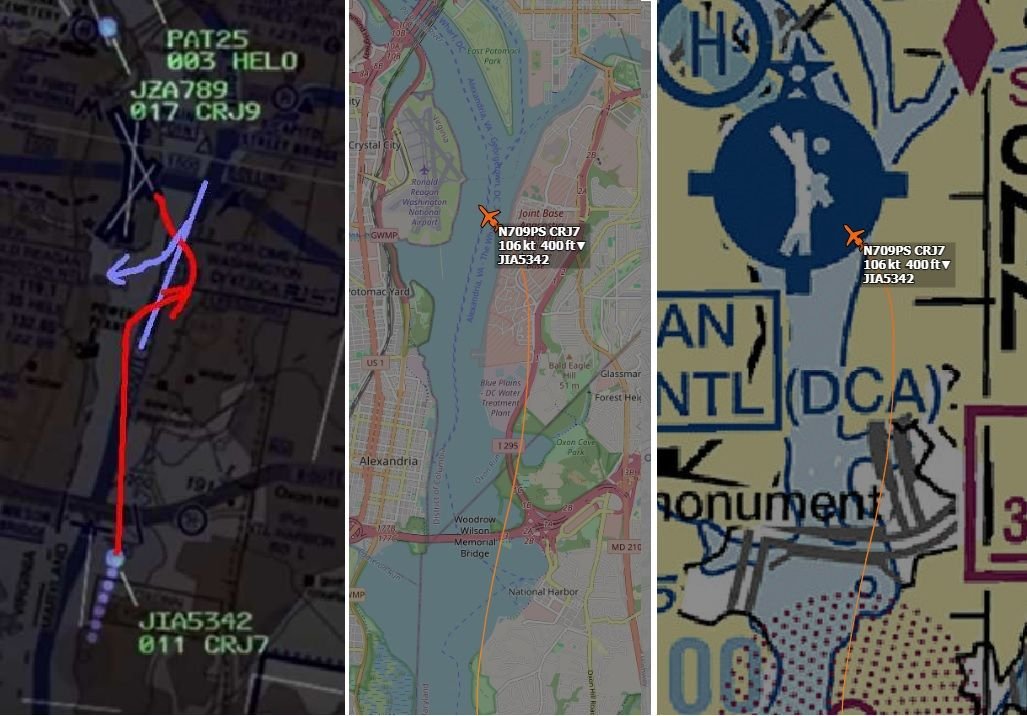
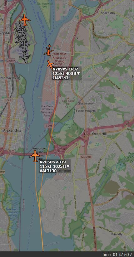
The position of the collision shown in the radar data overlay is consistent with the position of the RJ as shown in ADS-B Exchange at the time of the collision (approximately 01:47:59Z according to the NTSB timeline). See this link from DIBO for the RJ Track with timing AA5342 Down DCA In my experience, times in ADS-B Exchange are generally accurate to within 2 seconds. Given all that, I believe that the Black Hawk was within the horizontal bounds of Route 4 at the time of the collision and that it did not make the right turn we see in the ADS-B Exchange map.
Edit: Corrected route number and helicopter
Last edited by airplanecrazy; 6th February 2025 at 01:24 .
Subjects
AA5342
ADSB (All)
Blackhawk (H-60)
DCA
NTSB
Radar
Route 4
Links are to this post in the relevant subject page so that this post can be seen in context.
Reply to this quoting this original post. You need to be logged in. Not available on closed threads.
February 06, 2025, 14:36:00 GMT
permalink Post: 11823021
Owing to the vision limitations caused by use of NVG's it is not out of the realm of consideration Army policy would require for two crew members in the rear of the aircraft to enhance conflict resolution.
We routinely flew Chinooks with three crew in the rear with two designated to watch for traffic on either side of the aircraft. The third crew member was the Flight Engineer who controlled activities in the rear and performed safety checks. That simple concept saved my Bacon more than a few times.
Subjects
Blackhawk (H-60)
CRJ
Night Vision Goggles (NVG)
Links are to this post in the relevant subject page so that this post can be seen in context.
Reply to this quoting this original post. You need to be logged in. Not available on closed threads.
February 06, 2025, 20:50:00 GMT
permalink Post: 11823205
They could only later identify the correct light spot by following its trajectory according to their mental image of the approach to 33.

Subjects
Blackhawk (H-60)
CRJ
New York Times
Links are to this post in the relevant subject page so that this post can be seen in context.
Reply to this quoting this original post. You need to be logged in. Not available on closed threads.