February 07, 2025, 10:27:00 GMT
permalink Post: 11823522
They could only later identify the correct light spot by following its trajectory according to their mental image of the approach to 33.

Subjects
Blackhawk (H-60)
CRJ
New York Times
Links are to this post in the relevant subject page so that this post can be seen in context.
Reply to this quoting this original post. You need to be logged in. Not available on closed threads.
February 07, 2025, 14:59:00 GMT
permalink Post: 11823702
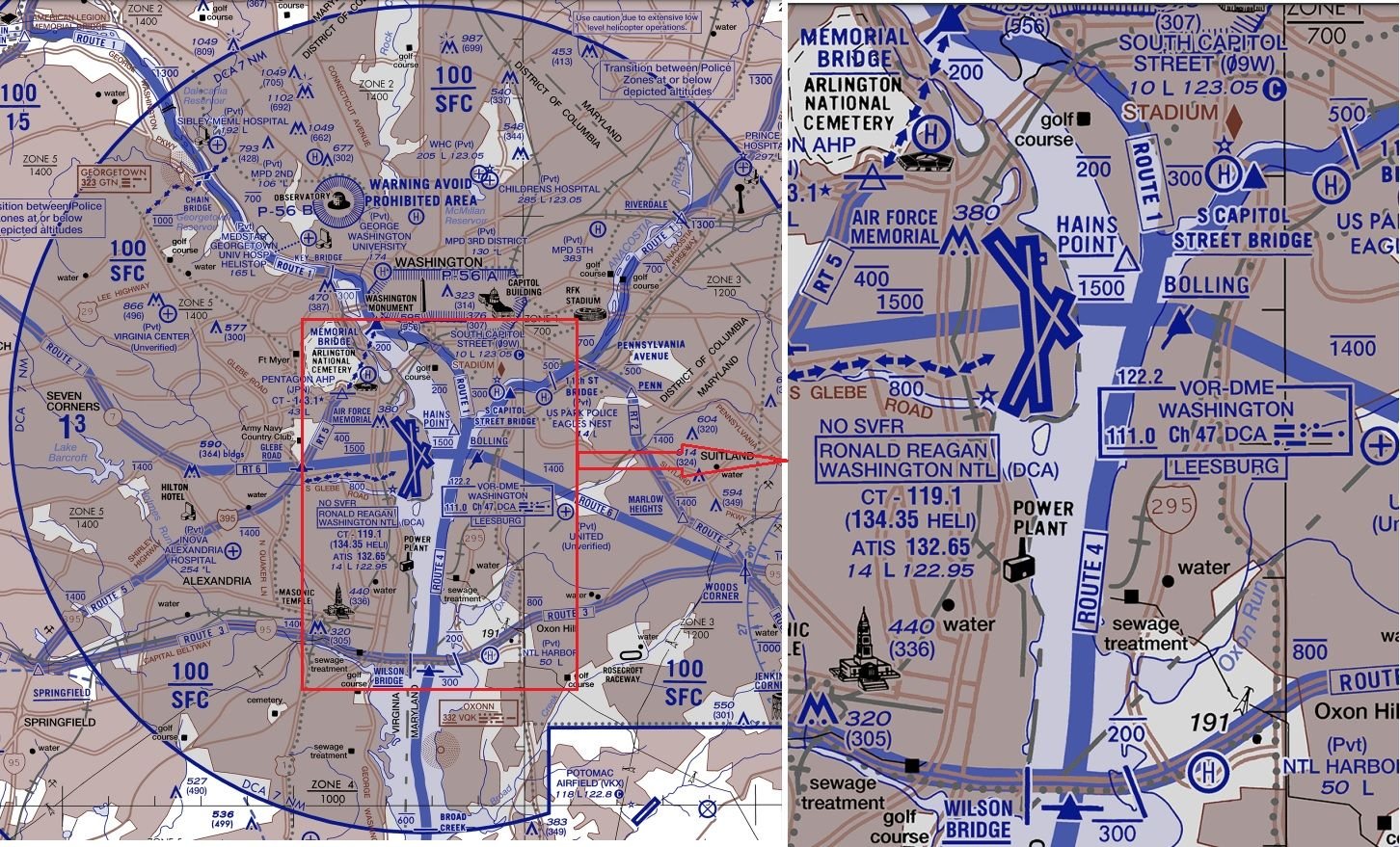
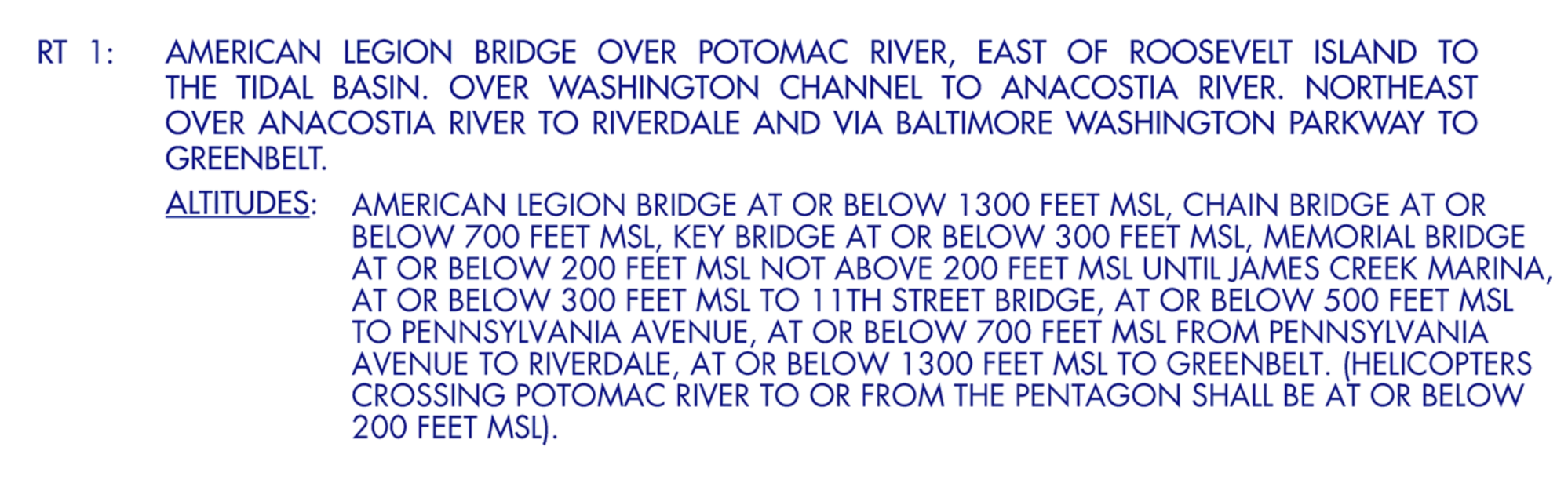
Anything approaching Rwy 1 should be below ~700ft anywhere north of the sewage treatment marker; use the Wilson Bridge for a bit of headroom because not all aircraft are going to be perfectly on glideslope.
The river is far narrower than 1.5Nm so clearly a southbound helicopter on Route 4 can never cross a northbound aircraft approaching runway 1 north of the Wilson Bridge.
You'd have to hold a southbound helicopter north of either the Memorial or Capitol St Bridges until previous traffic had landed. Then have a sufficiently large gap with no arrivals (or departures until south of the runways) for the helicopter to reach the Wilson St Bridge before the next arrival crosses that bridge.
That's the preceding aircraft covering ~3Nm at 140kt (~80s), followed by the helicopter covering ~6Nm at ~100kt (another 3.5min), and accurately timing the next arrival so it doesn't cross the Wilson bridge until after the helicopter, or it needs to do a go-around.
Subjects
Route 4
Route 5
Separation (ALL)
Links are to this post in the relevant subject page so that this post can be seen in context.
Reply to this quoting this original post. You need to be logged in. Not available on closed threads.
February 07, 2025, 22:21:00 GMT
permalink Post: 11823972
Subjects: None
No recorded likes for this post (could be before pprune supported 'likes').Reply to this quoting this original post. You need to be logged in. Not available on closed threads.
February 08, 2025, 05:02:00 GMT
permalink Post: 11824104
The river is 4000 feet wide just south of that designated point. I imagine there is a procedure otherwise what would be the point?
The other option is that they would have to have the landing traffic go around.
...
Subjects: None
No recorded likes for this post (could be before pprune supported 'likes').Reply to this quoting this original post. You need to be logged in. Not available on closed threads.
February 08, 2025, 10:23:00 GMT
permalink Post: 11824232
Interesting also that the legend clearly describes the \x93Route Altitudes\x94 as \x93Recommended\x94 (not compulsory), therefore PAT25 being at 300\x92 while not being recommended, was not breaking any rules.
Subjects
PAT25
Links are to this post in the relevant subject page so that this post can be seen in context.
Reply to this quoting this original post. You need to be logged in. Not available on closed threads.
February 08, 2025, 11:26:00 GMT
permalink Post: 11824272
Subjects
PAT25
Links are to this post in the relevant subject page so that this post can be seen in context.
Reply to this quoting this original post. You need to be logged in. Not available on closed threads.
February 10, 2025, 17:17:00 GMT
permalink Post: 11825626
I think the point may be that in those 50yrs you may actually have made a mistake identifying an aircraft, but we don’t have the data. Just because you didn’t have a collision or Airmiss you can’t say for certain that everything worked perfectly.
If you mistakenly identify the wrong aircraft, but don’t realise and don’t actually hit anything and the other party also don’t notice/report, then the error is never recognised, nor recorded. Are we suggesting that this scenario has never happened in the history of aviation?
A flight that doesn’t end in a crash does not mean it was perfect.
I think many pilots would have made a mistake indentifying : seen from the helo, there are 3 aircraft in final, plus 1 on take-off, at the same bearing, how can you tell for sure which is the one "just south of Wilson Bridge" ?
They could only later identify the correct light spot by following its trajectory according to their mental image of the approach to 33.
Last edited by Senior Pilot; 10th February 2025 at 21:20 . Reason: Image source
Subjects
Blackhawk (H-60)
CRJ
New York Times
Links are to this post in the relevant subject page so that this post can be seen in context.
Reply to this quoting this original post. You need to be logged in. Not available on closed threads.
February 10, 2025, 17:56:00 GMT
permalink Post: 11825641
Subjects: None
No recorded likes for this post (could be before pprune supported 'likes').Reply to this quoting this original post. You need to be logged in. Not available on closed threads.
February 10, 2025, 18:56:00 GMT
permalink Post: 11825666
I think many pilots would have made a mistake indentifying : seen from the helo, there are 3 aircraft in final, plus 1 on take-off, at the same bearing, how can you tell for sure which is the one "just south of Wilson Bridge" ?
They could only later identify the correct light spot by following its trajectory according to their mental image of the approach to 33.
At the same time the accident aircraft peels off to the right to swing around and line up to 33, thus taking his (smaller) lights out of the helicopter's direct line of vision and leaving 3130's (brighter) lights still heading to 01 to decoy the pilot. The reflexive nature of the helicopter's responses suggest to me that the full implication of 'circling to 33' in the tower's first call was missed, and also sort of implies that the helicopter could not conceive that following (nearly) the published heliroute could lead him into conflict with an aircraft on final. Me neither.
Last edited by Senior Pilot; 10th February 2025 at 21:22 . Reason: Quote
Subjects
Blackhawk (H-60)
CRJ
DCA
New York Times
PAT25
Separation (ALL)
Visual Separation
Links are to this post in the relevant subject page so that this post can be seen in context.
Reply to this quoting this original post. You need to be logged in. Not available on closed threads.
February 11, 2025, 00:18:00 GMT
permalink Post: 11825784
Subjects
PAT25
Links are to this post in the relevant subject page so that this post can be seen in context.
Reply to this quoting this original post. You need to be logged in. Not available on closed threads.
February 11, 2025, 06:13:00 GMT
permalink Post: 11825867
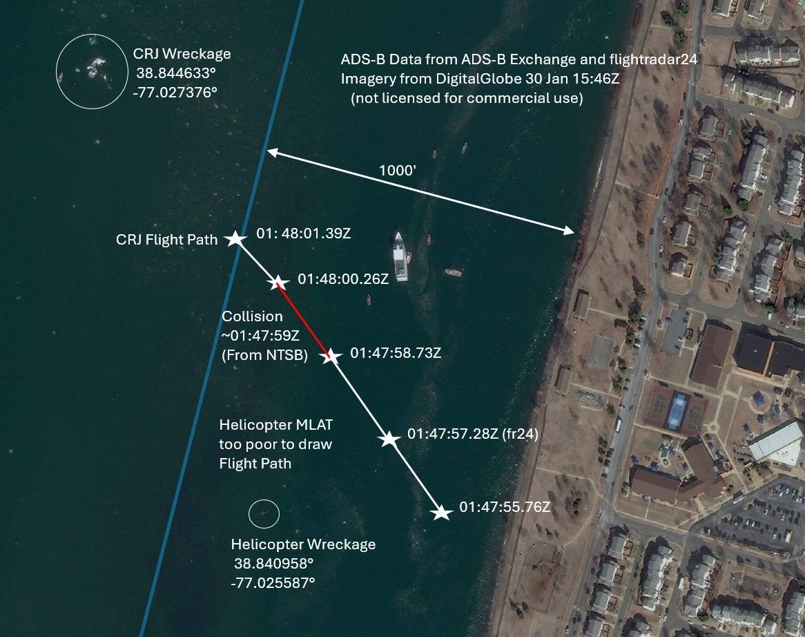
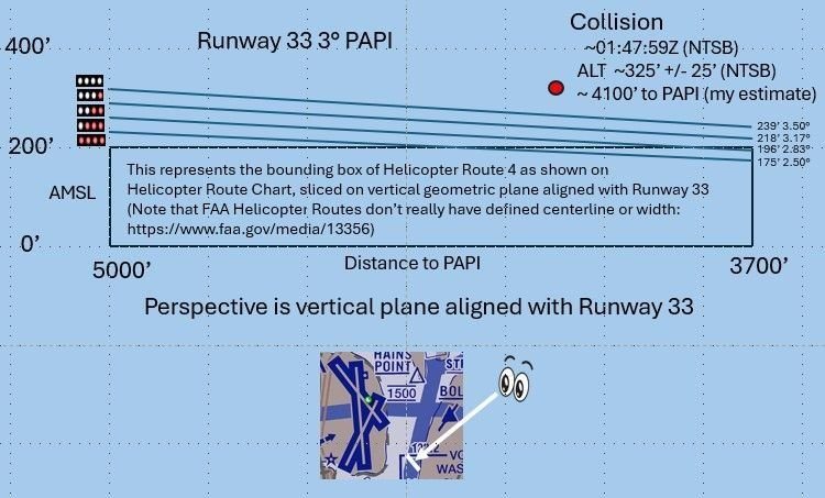
On the other hand the collision will have somewhat altered trajectory of both aircraft, so maybe the collision had still occured over land and due to the lateral energy transfer the Helicopter was thrown off its original course towards the West and into the river. We will get this information finally.
And in the end it doesn't really make that much of a difference wrt the level of lunacy of this whole setup.

Collision Altitude vs PAPI
Last edited by airplanecrazy; 11th February 2025 at 06:30 . Reason: Problem with picture. Awkward phrasing
Subjects
ADSB (All)
Blackhawk (H-60)
FAA
NTSB
Links are to this post in the relevant subject page so that this post can be seen in context.
Reply to this quoting this original post. You need to be logged in. Not available on closed threads.
February 11, 2025, 09:56:00 GMT
permalink Post: 11825962
Speculation : The helicopter crews know that if they don't report traffic in sight as soon as it's called, they'll be slowed down and deprioritised by ATC and eventually held back until they either do report the traffic, or there's a substantial gap in arrivals - see the LH A380. That makes them unpopular with their passengers and/or superiors, so they are very flexible with what 'in sight' means.
ATC likewise knows that if they push helicopter crews too hard on altitude busts, report anything involving a helicopter, or hold up either kind of traffic, they might get people breathing down their neck and certainly nothing good comes of it.
Calling traffic immediately and not enforcing separation too strictly allows both parties to 'get on with their jobs' while looking more-or-less by-the-book - until an incident like this happens.
I'm hopeful I'm wrong, but given there seems to be a long history of near misses and altitude busts this seems like the obvious conclusion. No-one high-up wanted to hear about it or change anything , because no-one had died yet.
On a slightly different note, I'm curious whether anyone is familiar with the Hierarchy of Controls by NIOSH? It doesn't map 1:1 to aviation, but it codifies some things that are 'obvious' in hindsight:
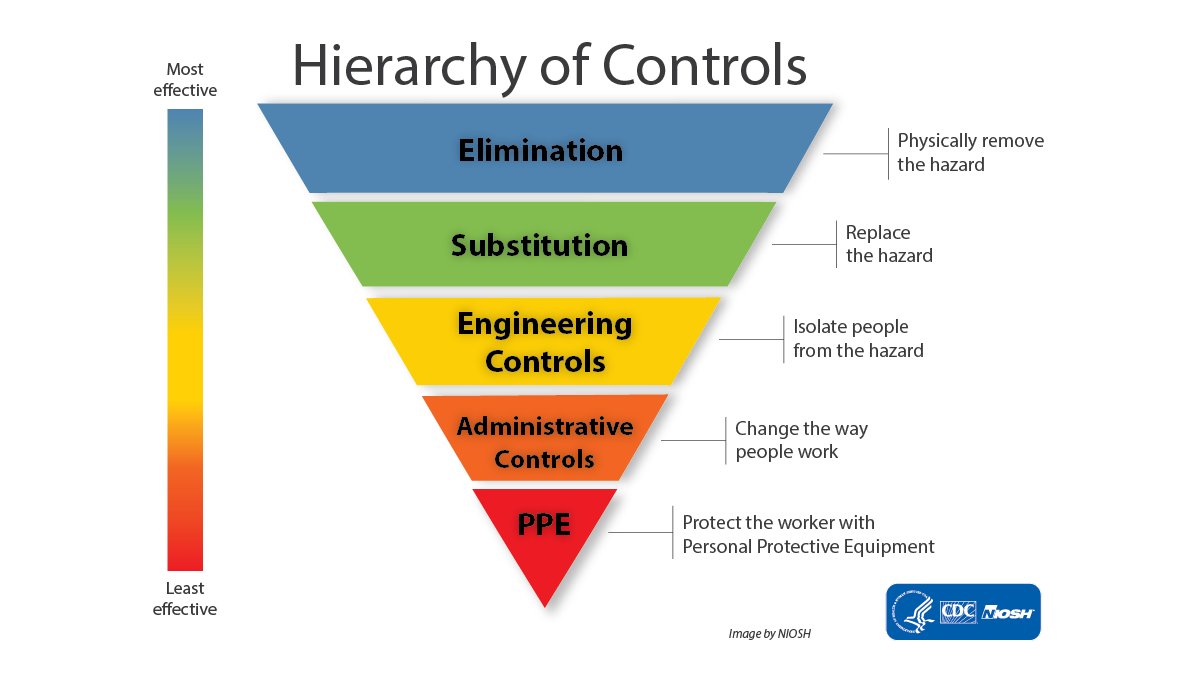
Broadly speaking, some controls are more effective than others. Wherever possible, you should attempt to use more effective controls in place of less effective ones. More effective means not just that it reduces the risk the most, but also the most reliable over time and most resistant to having rules bent, being left broken, being ignored due to alarm fatigue, or 'normalisation of deviation'. Procedures that assume everything is working perfectly and everyone is 100% competent will fail; see MCAS and a great number of other accidents.
Elimination is rarely possible but substitution (radar vs visual) and isolation (separate helicopters from other traffic) amongst other engineering controls are potentially more feasible, and much higher up the hierarchy than a glorified instruction not to crash (the very bottom of administrative). Engineering a problem out of existence is far superior to having a procedure to fix it in the QRH.
I list things like TCAS, GPWS, RSAs, and crash-proof seating as broadly being under PPE: they're nice to have and certainly worth pursuing, but unless there is no other alternative, they should never be your primary protection. Something has gone wrong if they get used.
Subjects
ATC
Close Calls
Normalization of Deviance
Radar
Separation (ALL)
TCAS (All)
Traffic in Sight
Links are to this post in the relevant subject page so that this post can be seen in context.
Reply to this quoting this original post. You need to be logged in. Not available on closed threads.
February 11, 2025, 19:28:00 GMT
permalink Post: 11826281
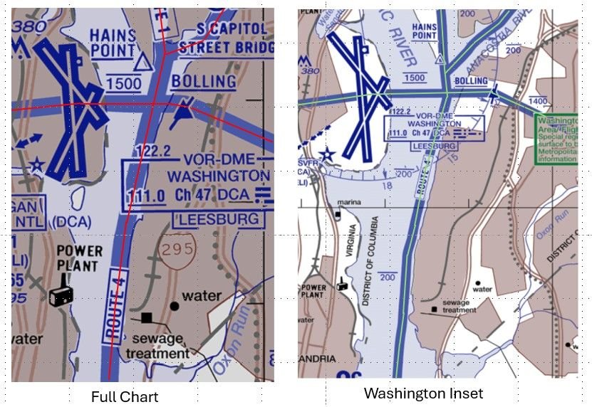
DCA Helicopter Routes
Given these chart differences, I wonder how far a helicopter can stray from the various depictions of a route before it is considered a pilot deviation? Perhaps the NTSB will give us some insight with their accident report.
Last edited by airplanecrazy; 14th February 2025 at 23:53 . Reason: Emphasize the route "appear"
Subjects
DCA
FAA
NTSB
PAT25
Route 4
Separation (ALL)
Visual Separation
Links are to this post in the relevant subject page so that this post can be seen in context.
Reply to this quoting this original post. You need to be logged in. Not available on closed threads.
February 11, 2025, 22:31:00 GMT
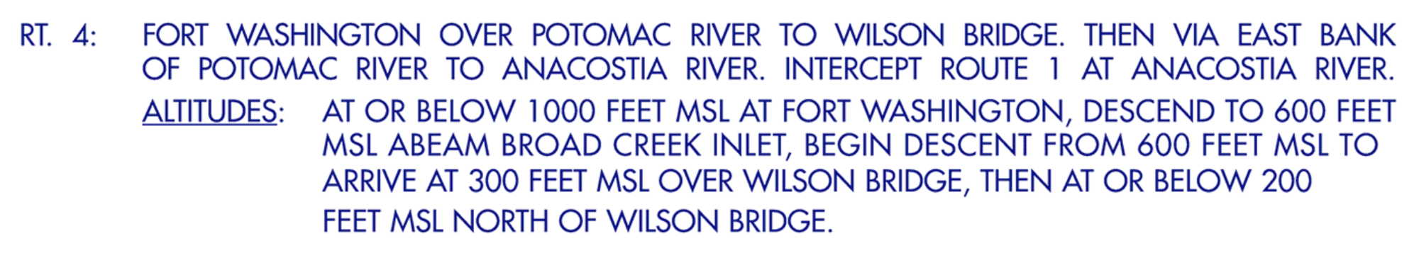
permalink Post: 11826358
DCA Helicopter Routes
Given these chart differences, I wonder how far a helicopter can stray from the various depictions of a route before it is considered a pilot deviation? Perhaps the NTSB will give us some insight with their accident report.
"...FAA depicted width of a helicopter route is governed by the following doc: https://www.faa.gov/air_traffic/flight_info/aeronav/iac/media/IAC15/IAC-15-22AUG2022-complete.pdf "
I think that the "width" that you are referring is for the chart maker but not the actual width of a helicopter route.
I can't find in any FAA document a definition of the lateral extent of a helicopter route. Is there one?
There are inconsistencies between the "DESCRIPTION OF ROUTES AND ALTITUDES" and the charts themselves. The Merriam-Webster's 11th Collegiate Dictionary definition of "BANK 2 : the rising ground bordering a lake, river, or sea or forming the edge of a cut or hollow."
for example "RT. 4: ... VIA EAST BANK OF POTOMAC RIVER..." while the chart depicts RT. 4 over the POTOMAC RIVER not over the ground bordering the river.
while "RT. 15: ... ALONG THE WESTERN SHORE OF THE CHESAPEAKE BAY AND PATAPSCO RIVER..." and the chart depicts RT. 15 over water.
Last edited by airman1900; 11th February 2025 at 22:33 . Reason: punctuation and quote
Subjects
DCA
FAA
NTSB
Links are to this post in the relevant subject page so that this post can be seen in context.
Reply to this quoting this original post. You need to be logged in. Not available on closed threads.
February 12, 2025, 17:30:00 GMT
permalink Post: 11826835
One ATCO, worked , at three separate frequency, three runways, 6 aircraft for arrival 01, one a/c 33, plus three helicopter, plus how many departures ( both active and approaching/crossing active runways) ?
Plus active estimate for a few aircraft more?
Ground vehicles, any?

Subjects
ATCO
PAT25
Links are to this post in the relevant subject page so that this post can be seen in context.
Reply to this quoting this original post. You need to be logged in. Not available on closed threads.
February 14, 2025, 07:18:00 GMT
permalink Post: 11827820
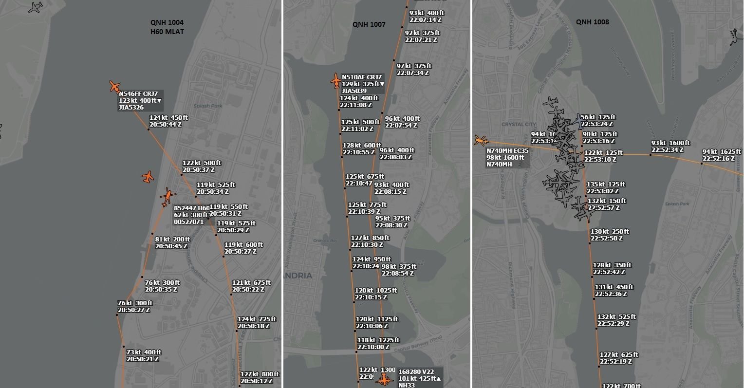
FWIW, this is my take on the layout of the crash scene:
Crash Scene
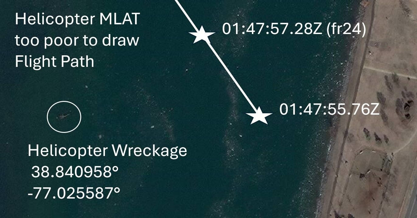
Zoom on helicopter
Last edited by airplanecrazy; 14th February 2025 at 07:49 . Reason: Fixed pictures
Subjects: None
1 recorded likes for this post.Reply to this quoting this original post. You need to be logged in. Not available on closed threads.
February 15, 2025, 10:26:00 GMT
permalink Post: 11828492
...
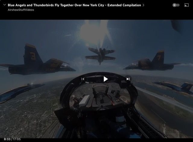
I was recently watching a video on the highlights of Oshkosh, the relevance of which will hopefully become clear shortly.
One part of the video was some POV footage from the cockpit of one of the Blue Angels. I had a 'double-take' and triple rewind to confirm what I thought I saw on the glareshield: I think I saw a piece of portable avionics that is very, very familiar to me.
Is any expert able to confirm what that white block on the glareshield is?
I've been in a discussion about the complexity of avionics upgrades to military flying machinery, the discussion precipitated by the differing terminology about "fitted with" and "equipped with" and "carried". And I suggest that even if the helo was "fitted with" an ADS system, at the altitude the aircraft were operating at the time of the collision any alerts may have been suppressed.
Subjects: None
No recorded likes for this post (could be before pprune supported 'likes').Reply to this quoting this original post. You need to be logged in. Not available on closed threads.
February 15, 2025, 21:35:00 GMT
permalink Post: 11828846
Disconcerting that the PAT 25 crew, about to descend and fly less than 200 feet AGL , would not have investigate the discrepancy of 100 feet between their respective altimeters...
Details of instrumentation here:
https://apps.dtic.mil/sti/tr/pdf/ADA409934.pdf
Not completely obvious in the photo is the digital display of radar altitude just underneath the annotation ABS ALT. The technical manual also mentions a three digit radar altitude displayed on the HUD.
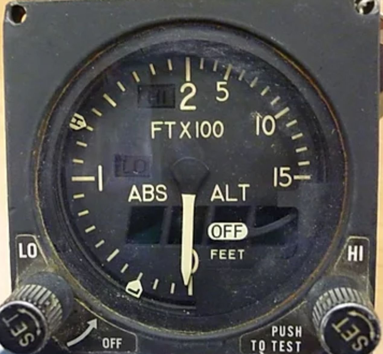
Last edited by Stagformation; 15th February 2025 at 23:01 .
Subjects
Altimeter (All)
HUD
Radar
Links are to this post in the relevant subject page so that this post can be seen in context.
Reply to this quoting this original post. You need to be logged in. Not available on closed threads.
February 17, 2025, 06:24:00 GMT
permalink Post: 11829650
You could reasonably define the bank as the water's edge, and therefore expect crews to fly along an infinitesimally narrow path. Or as the space between the water's edge and the [edge of the flood plain | first flat area | something else], which would imply that the western boundary changes with the water level. Both imply the route is substantially above land.
Neither are useful for precise navigation, but the map and the description are probably 'close enough' if they are only needed for general route guidance and knowing that structures on the east bank need to be NOTAMed for helicopters, but probably not the west bank.
A good reminder that measurements/specifications without tolerance are often worse than useless.
If it quacks like a duck... this kind of "It can't be an X because we can't do it, so we'll call it a Y" leads to a culture that gets used to massaging the truth for convenience. Did we hear more on the Alaska door plug that was an 'opening' not a 'removal'?
Subjects
ATC
CRJ
DCA
FAA
KDCA
NTSB
Night Vision Goggles (NVG)
Pass Behind
Pass Behind (All)
Separation (ALL)
Links are to this post in the relevant subject page so that this post can be seen in context.
Reply to this quoting this original post. You need to be logged in. Not available on closed threads.
February 17, 2025, 12:54:00 GMT
permalink Post: 11829882
If everyone had been flying at the prescribed altitudes, the CRJ should have passed 40ft over the Blackhawk, I can't believe that would have been OK.
I was very surprised also to hear Jennifer tell us that the heliroutes have no lateral boundaries, which is a bit bizarre given that the Route 4 in the notes on the chart is described as following the East bank of the Potomac which is about on the left end of the diagram. Doesn't matter though, same problem there. Routes shouldn't be designed so that aircraft can infringe on landing (or any other kind) of passenger jet traffic.
Subjects
Blackhawk (H-60)
CRJ
Route 4
Links are to this post in the relevant subject page so that this post can be seen in context.
Reply to this quoting this original post. You need to be logged in. Not available on closed threads.