February 19, 2025, 22:00:00 GMT
permalink Post: 11831783
Added note: The chart shows only crossings collected with ADS-B. I threw out all MLAT collected crossing because of inherent inaccuracy.
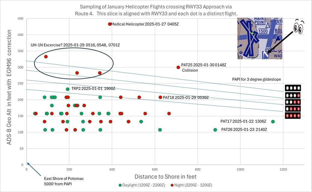
Helicopters crossing RWY 33 approach via Route 4 for January
Last edited by airplanecrazy; 19th February 2025 at 22:26 .
Subjects
ADSB (All)
ATC
Route 4
Links are to this post in the relevant subject page so that this post can be seen in context.
Reply to this quoting this original post. You need to be logged in. Not available on closed threads.
February 19, 2025, 23:33:00 GMT
permalink Post: 11831851
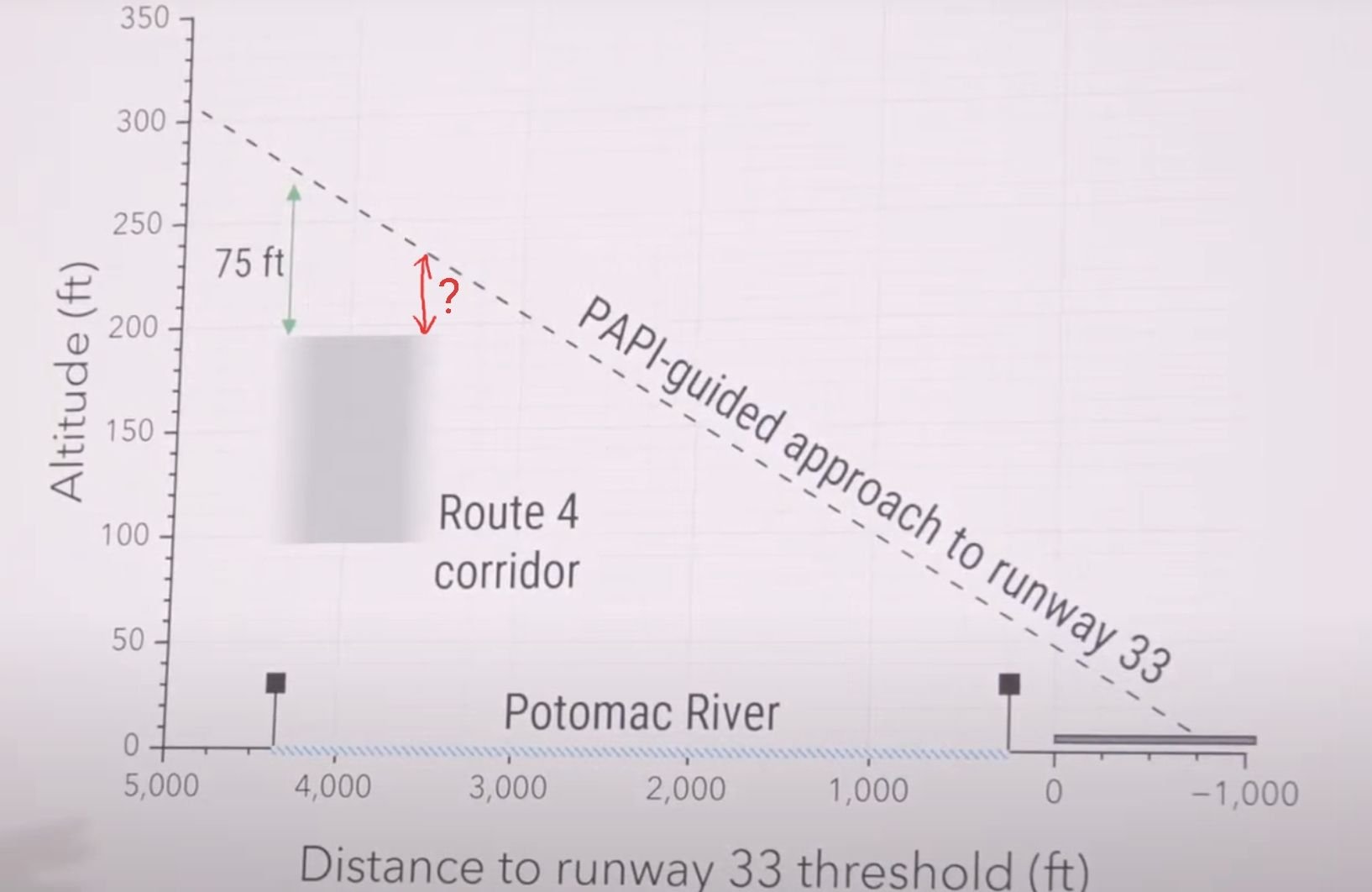
(I've assumed that the altitude is recorded in the closest bin to the actual value. If that's not the case then the error bars would be 25 feet in one direction or the other depending on whether it rounds up or down. An ADSB geek would know. I am also itching to know whether the origin point of your glidepath lines has been adjusted to the same EGM96 height datum as the ADSB values...)
As for your question on the glideslope, I did NOT properly account for the EGM96 correction. The new chart moves the glideslope up 5' to meet the height of the PAPI as measured in Google Earth (18'), which uses EGM96. Is that reasonable? I should also add a couple of feet to account for the height of the PAPI lights themselves. Does anyone know how much I should add? Thanks for the catch.
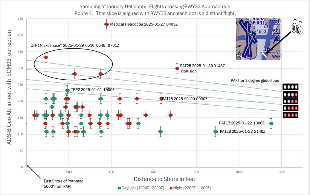
Helicopters crossing RWY 33 approach via Route 4 for January (updated)
Last edited by airplanecrazy; 19th February 2025 at 23:49 . Reason: Adjusted PAPI lights up 5 feet
Subjects
ADSB (All)
Route 4
Links are to this post in the relevant subject page so that this post can be seen in context.
Reply to this quoting this original post. You need to be logged in. Not available on closed threads.
February 21, 2025, 01:58:00 GMT
permalink Post: 11832670
So it's basically a high stakes game of Crossy Road.
Subjects: None
No recorded likes for this post (could be before pprune supported 'likes').Reply to this quoting this original post. You need to be logged in. Not available on closed threads.
March 04, 2025, 14:56:00 GMT
permalink Post: 11840670
Fixed wing
AAL1630, departed 1, waiting handoff to departure
JIA5305, holding short 1, #2
DAL832, holding short 1 #3
JIA5342, cleared to land 33
AAL3130, cleared to land 1
AAL472, cleared visual 1
JIA5347, cleared visual 1, requested 33
Rotary wing
PAT25
helo, Zone 4
helo, callsign Blackjack 1, freq change approved just prior
helo, callsign Muscle 12, handed off to ADW prior
helo, request Route 3, Zone 6
helo, Zone 7
Medevac AirCare helo, proceeding to Inova Fairfax
Some of the helo\x92s on above list may be duplicates due to poor audio quality.
At the time of the accident, runway 4/22 was not in use.
pretty sure I was the circled aircraft that night, AA1855 from CLT. We were just about to be cleared onto the MTV1 when it happened. Did not see it happen but pretty sure we heard JIA5342 being handed off to tower. We were then vectored off the approach and eventually diverted to IAD. Tragic night.
Subjects
ATC
PAT25
Links are to this post in the relevant subject page so that this post can be seen in context.
Reply to this quoting this original post. You need to be logged in. Not available on closed threads.
March 08, 2025, 09:24:00 GMT
permalink Post: 11843284
Subjects: None
No recorded likes for this post (could be before pprune supported 'likes').Reply to this quoting this original post. You need to be logged in. Not available on closed threads.
March 08, 2025, 10:58:00 GMT
permalink Post: 11843333
Subjects: None
No recorded likes for this post (could be before pprune supported 'likes').Reply to this quoting this original post. You need to be logged in. Not available on closed threads.
March 11, 2025, 22:29:00 GMT
permalink Post: 11845719
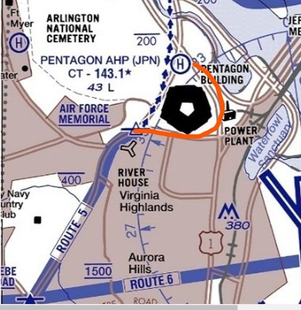
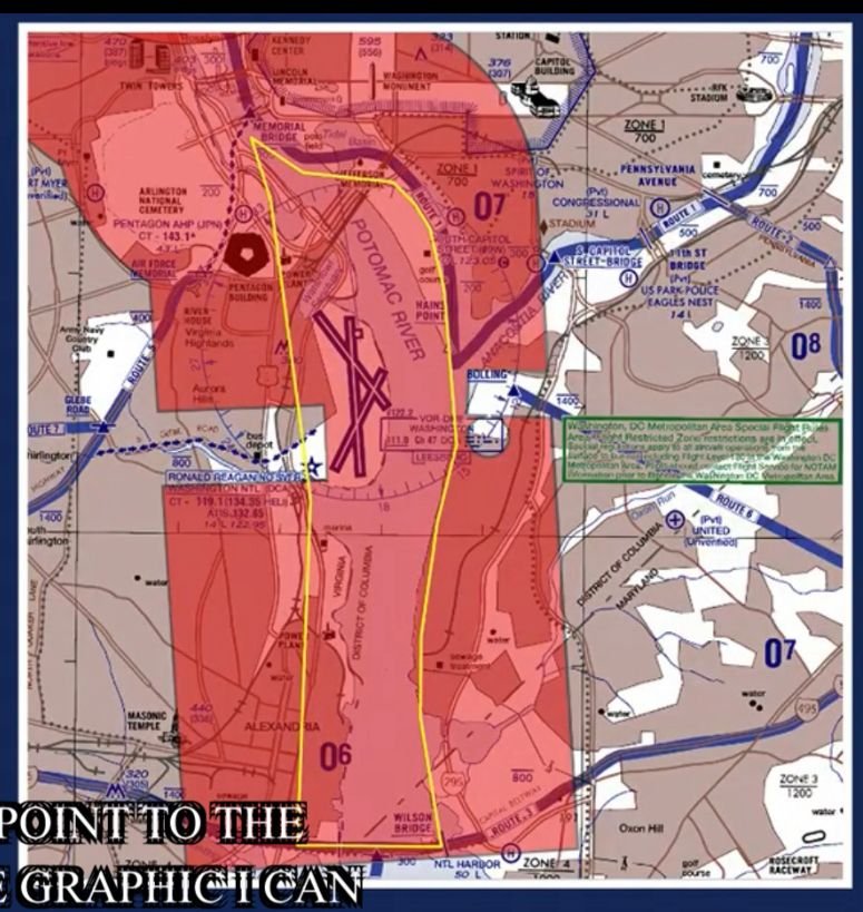
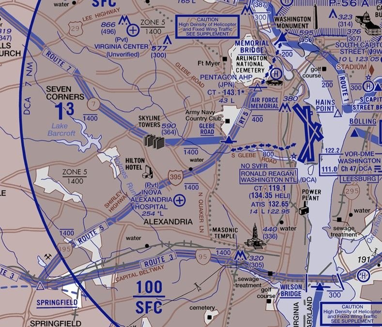
The chart shows the dotted routes connecting 1 and 5 to the Pentagon helipad. But much of the time, the PAT helos would fly the red line - as I observed earlier, over a raised highway with light poles, and cutting under the RW15 approach at about half the distance to the runway end.
I just base this on what I can see locally. I walk almost daily parallel to the rail line and it was no big deal to see the PATs following 395 around the east side of the building - but that's not where the chart says Route 5 is.
By the way a midair over 395 would put debris into a heavily used outdoor sports complex.
PS Observed two more go-arounds from RW18 this afternoon!
Subjects
Route 5
Links are to this post in the relevant subject page so that this post can be seen in context.
Reply to this quoting this original post. You need to be logged in. Not available on closed threads.
March 11, 2025, 23:10:00 GMT
permalink Post: 11845750
The chart shows the dotted routes connecting 1 and 5 to the Pentagon helipad. But much of the time, the PAT helos would fly the red line - as I observed earlier, over a raised highway with light poles, and cutting under the RW15 approach at about half the distance to the runway end.
I just base this on what I can see locally. I walk almost daily parallel to the rail line and it was no big deal to see the PATs following 395 around the east side of the building - but that's not where the chart says Route 5 is.
By the way a midair over 395 would put debris into a heavily used outdoor sports complex.
PS Observed two more go-arounds from RW18 this afternoon!
https://www.airnav.com/airport/KJPN
FAA Information for KJPN, effective 20 Feb 2025, has amongst Additional Remarks:\x97
CAUTION - TFC PAT - KJPN EAST/WEST OPS. SPECIAL PRO TFC PAT. WHEN LDG W ALL ARR ACFT MAKE LEFT TFC CIRCLING THE PENTAGON AT OR BLW 200 FT. WHEN DEP E ALL ACFT MAKE RIGHT TFC CIRCLING THE PENTAGON AT OR BLW 200 FTSubjects
Route 5
Links are to this post in the relevant subject page so that this post can be seen in context.
Reply to this quoting this original post. You need to be logged in. Not available on closed threads.
March 21, 2025, 11:20:00 GMT
permalink Post: 11851281
 I always read you input as, while the detailed legal nitty-gritty is generally way beyond me, you always provide a refreshing viewpoint which is good to read! The aim of my Post, based on my interpretation of the above quote, was just to emphasise the existence of ASIAS is just as a tool or, rather, a set of tools but which has no real "proactive function" in itself. Yes, it represents a very small part of the Flight Safety chain - but as a resource in the main. As you say, there were loads of examples of what happened at DCA and my post was an explanation as to who, I believe, should have been looking at it. Maybe they did - and just ignored it? No idea!
In the UK, the airport operator is totally responsible for the safety of operations on or above their field out to 4000 ft on approach and departure - about 12 miles. The CAA who regulates aviation here, along with the Dept of Transport, but in conjunction with other stakeholders such as NATS (our en-route ATC organsiation), airlines and airfield operators etc, designs the airspace and sets the generic rules for it's use. As you said, the main rule is "Don't crash anything into anything else!". However, at the airfield, it is the airport operator who needs to ensure that the generic rules work in their environment. If a particular rule is legal but, if applied in their location, is unsafe, they can't apply that rule! That's what the Safety Case should say.
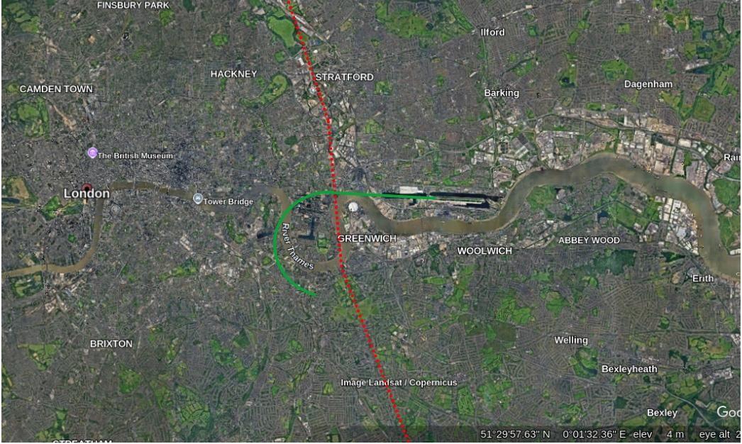
A relevant example? I used to regularly (for work) transit London S > N and N > S along the red dotted line below - at 2400ft as it kept me just out of the London TMA but as high as possible so, if it had all gone quiet on the engine front, I'd have the best chance to get the plane onto the ground with me alive and no-one else hurt. As part of the transit, I had to cross the final approach into London City (green line). So, say heading N, I'd chat to Thames Radar while over South London and would ask for a London City crossing. They'd chat to City ATC to co-ordinate and take me to the Thames before handing me to City Tower. My route over the Approach has aircraft at 1200 ft descending on the ILS and so I would have crossed anything landing at 1200 ft above that. So, while on first glance, it was fine I never, ever got that clearance with an aircraft landing - and for very good reasons. If the aircraft on the ILS had had to do a go-around, life could have become interesting very quickly. I was always held until the landing aircraft was well clear (ie ATC could see it was almost at the airfield) before they cleared me across. Indeed, legally, they could have given me a "You see the landing? Pass behind that"! But, no - always positive clearances. Got my vote ....... + gave me chance to enjoy the views of Greenwich and the City of London and "delayed" me a couple of minutes. OK, a bit unfair as LCY is "sleepy hollow" compared to DCA but, despite that, they were very friendly ..... but very strict!!!!!
So, when you are discussing (I think!!!) whether ATC elected to give PAT25 a "You visual? Pass behind" or whether it was "ordered" from on-high as it was deemed safe to do, ultimately, it is the ATCOs call on the day. Now, before I get flamed, do I blame the ATCO ? No! Well, why not? After all, he gave PAT permission! And yes, it was a "legal" clearance. But was it a wise clearance? When unpacking that little lot you have to look at a raft of Human Factors which influenced that ATCO on that night. He was on his own so, probably, the only way he could cope with all he had on his plate was to try and shift some responsibility onto PAT25 - one less thing for him to juggle. But even then, he needed to be monitoring which he clearly was - but while very busy with other approaches and departures so he just picked up a concern too late as the audio shows - "Are you sure you see the jet?". Another factor - was the strategy to use Route 4 while 33 was active something ATCers at DCA, over time, started in an effort to cut down radio traffic and speed things up? If so, had it been assessed and then monitored for adverse safety? While anecdotally, it seemed people were aware of "close calls", had any analysis taken place looking at the Databases? In the UK certainly, all the Airport Operator responsibility.
To the final "accountability" part re payments to families, the thing we have here is (and, folks, correct me if I've got this wrong) the FAA set the rules and the operate the Rules. Here, the CAA sets the rules and the Airfield Operator operates the rules. That is important - for eg, huge argument here in the UK about just how independent the UK's Military Flight Safety organisation is ..... as it is part of the Military. IMHO, what we have here are valid generic rules, some of which were simply not suitable in this specific location - just like crossing London City with an aircraft on approach - legal ...... but very unwise. As to who carries the can, well, as you said WR 6-3 , the legal beagles will get to the bottom of that ..... but it will take some time. I'll leave that side to you!!! My main question out of all of this is, why were not these issues flagged up by airport management for further investigation given it was something of an open "secret"? And where else (around the world) is this happening?

And, on that cheerful note...........! H 'n' H
Subjects
ATC
ATCO
Accountability/Liability
Close Calls
DCA
FAA
PAT25
Pass Behind
Pass Behind (All)
Radar
Route 4
Links are to this post in the relevant subject page so that this post can be seen in context.
Reply to this quoting this original post. You need to be logged in. Not available on closed threads.
March 23, 2025, 08:32:00 GMT
permalink Post: 11852481
Last edited by lakedude; 23rd March 2025 at 08:35 . Reason: change percent to degree
Subjects
Separation (ALL)
Links are to this post in the relevant subject page so that this post can be seen in context.
Reply to this quoting this original post. You need to be logged in. Not available on closed threads.
March 23, 2025, 10:35:00 GMT
permalink Post: 11852551
As for your question on the glideslope, I did NOT properly account for the EGM96 correction. The new chart moves the glideslope up 5' to meet the height of the PAPI as measured in Google Earth (18'), which uses EGM96. Is that reasonable? I should also add a couple of feet to account for the height of the PAPI lights themselves. Does anyone know how much I should add? Thanks for the catch.
Helicopters crossing RWY 33 approach via Route 4 for January (updated)
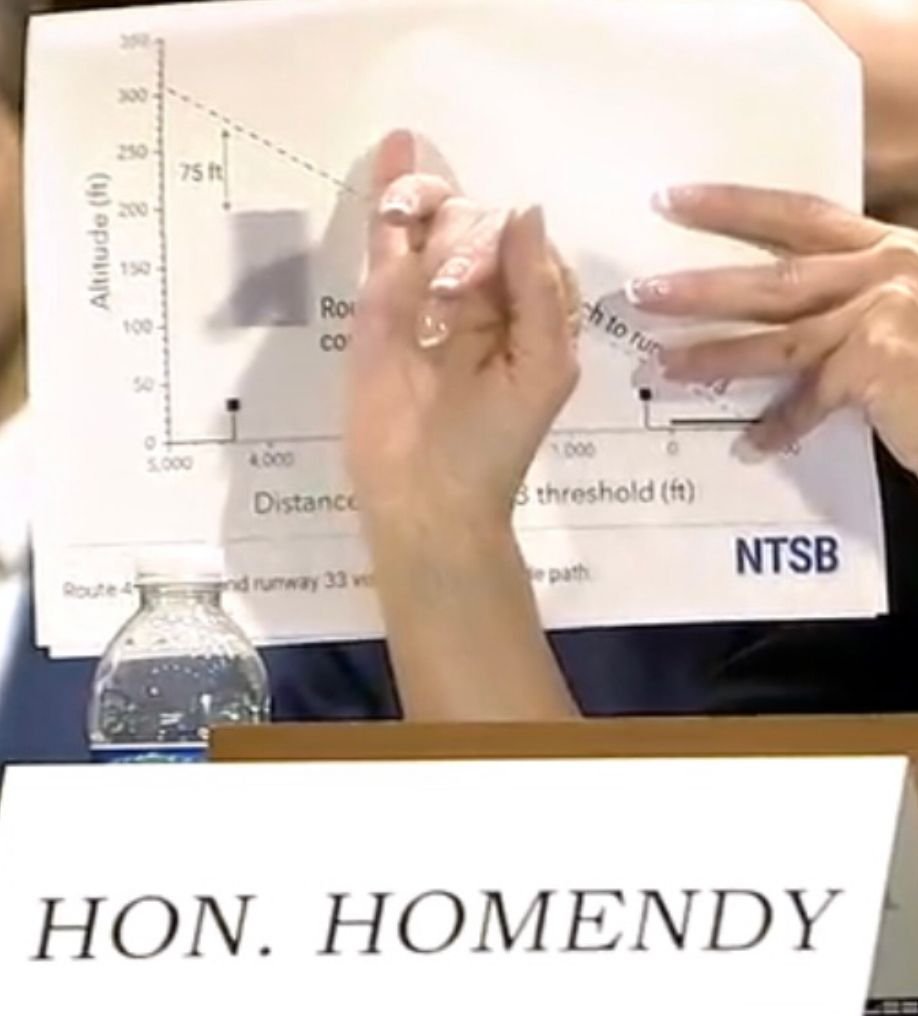
75' is plainly inadequate vertical clearance between two aircraft and doubling/tripling that would still be unacceptably close. Separation was surely expected to be achieved horizontally but the enforcement/implementation was lacking.
Subjects
ADSB (All)
Route 4
Separation (ALL)
Links are to this post in the relevant subject page so that this post can be seen in context.
Reply to this quoting this original post. You need to be logged in. Not available on closed threads.
March 26, 2025, 02:26:00 GMT
permalink Post: 11854317
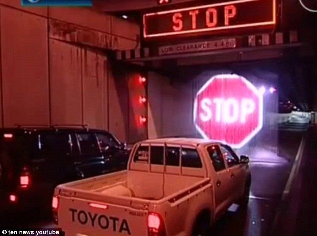
The classic 11'8" bridge of youtube fame has overheight lights. The bridge has since been slightly raised and the warning systems improved but still gets people driving straight through them.
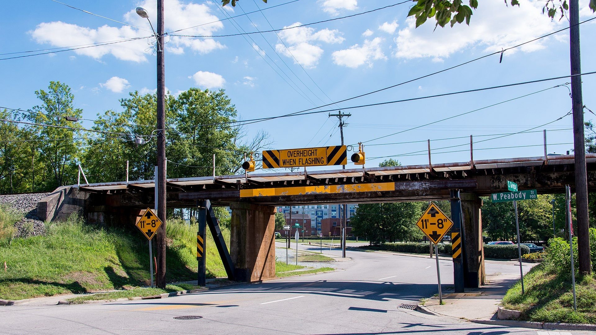
Even the London Underground has frangible fittings to detect taller surface stock trains incorrectly approaching a deep-level tube tunnel, throwing signals to danger and thus raising trainstops, which if passed apply the emergency brakes. The latter is important, because SPADs (Signal Passed At Danger) are still not uncommon.
They're not everywhere. It's a risk analysis based mainly on the inconvenience and cost of the cleanup and closure for the bridge/tunnel, and how many overheight vehicles are actually impacting the obstacle. They also don't work especially well because people assume the overheight warning couldn't possibly apply to them .
There's probably some degree of tolerance involved; e.g. bridge marked at 4.4m, sensors at 4.6m, bridge is actually 4.8m. I'm not sure what the actual standards are.
Subjects: None
No recorded likes for this post (could be before pprune supported 'likes').Reply to this quoting this original post. You need to be logged in. Not available on closed threads.
March 29, 2025, 02:27:00 GMT
permalink Post: 11856392
Subjects: None
No recorded likes for this post (could be before pprune supported 'likes').Reply to this quoting this original post. You need to be logged in. Not available on closed threads.
March 29, 2025, 16:50:00 GMT
permalink Post: 11856752
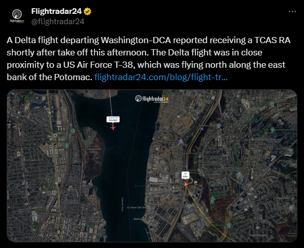
https://www.youtube.com/watch?v=bPQjQ23YTJo
" Delta Airlines A319 performing flight from Washington to Minneapolis was on the initial climb when the pilots received an onboard collision avoidance alert due to a flight of four T-38 Military Jets coming too close for a practice maneuver over the airport."
Subjects: None
No recorded likes for this post (could be before pprune supported 'likes').Reply to this quoting this original post. You need to be logged in. Not available on closed threads.
March 30, 2025, 21:14:00 GMT
permalink Post: 11857550
The altitude is still uncertain because of difference between jet and heli values and destruction of the heli altimeter. So work on that is continuing with a focus on other sources.
But note the 75 ft separation is a maximum. So if the heli was at 200ft then it was on the glide slope.
Another interesting point is that mixed heli and fixed wing is forbidden in the yellow zone (permanently), and ADSB mandatory in the red zone. With routes 4 and 6 cut.
See post below
Last edited by A0283; 30th March 2025 at 21:25 .
Subjects
ADSB (All)
Altimeter (All)
Close Calls
NTSB
Separation (ALL)
Links are to this post in the relevant subject page so that this post can be seen in context.
Reply to this quoting this original post. You need to be logged in. Not available on closed threads.
March 30, 2025, 21:17:00 GMT
permalink Post: 11857555
another item in the testimony was that generally 100% army helicopters flew there with ADSB set to OFF.
and that the accident heli might have put their ADSB to ON, but that the FAA had not received ADSB data from this heli in 730 days.
on ADSB there also was a difference between the Mike and Lima models,
NTSB chair indicated there was a lot more factual information. I wonder if the pull from Congress will lead to a change in the normal process, and release more factual information (with an appropriate disclaimer).
Subjects
ADSB (All)
FAA
NTSB
Links are to this post in the relevant subject page so that this post can be seen in context.
Reply to this quoting this original post. You need to be logged in. Not available on closed threads.
April 25, 2025, 21:45:00 GMT
permalink Post: 11873648
Also, note that it is now clearly marked that the flightpath is to the West of the Pentagon. One wonders what the reviewers thought of the Apocalypse Now hard-banking stunts around the east side of the building under the 15 approach.
Subjects
Route 5
Links are to this post in the relevant subject page so that this post can be seen in context.
Reply to this quoting this original post. You need to be logged in. Not available on closed threads.
May 02, 2025, 23:28:00 GMT
permalink Post: 11877447
Looks like someone did exactly that today, forcing two go-arounds.
Subjects: None
1 recorded likes for this post.Reply to this quoting this original post. You need to be logged in. Not available on closed threads.
May 05, 2025, 21:46:00 GMT
permalink Post: 11879061
However, after the Kentucky Derby (decadent and depraved) result, SecArmy tweeted:
Sovereignty > Journalism.
On the track. And in 2025 America.
If there was a VIP onboard, it would be a problem for the Administration.
Subjects: None
No recorded likes for this post (could be before pprune supported 'likes').Reply to this quoting this original post. You need to be logged in. Not available on closed threads.
May 06, 2025, 15:28:00 GMT
permalink Post: 11879473
However, after the Kentucky Derby (decadent and depraved) result, SecArmy tweeted:
Sovereignty > Journalism.
On the track. And in 2025 America.
If there was a VIP onboard, it would be a problem for the Administration.
Last edited by LowObservable; 6th May 2025 at 16:16 .
Subjects: None
No recorded likes for this post (could be before pprune supported 'likes').Reply to this quoting this original post. You need to be logged in. Not available on closed threads.