January 30, 2025, 04:40:00 GMT
permalink Post: 11816867
Subjects
ATC
CNN
KDCA
Links are to this post in the relevant subject page so that this post can be seen in context.
Reply to this quoting this original post. You need to be logged in. Not available on closed threads.
January 30, 2025, 15:47:00 GMT
permalink Post: 11817345
After LC provides CRJ at Wilson Bridge/1200ft/runway 33 traffic advisory, PAT25 requests visual separation, which LC immediately approves. This is several minutes prior to the collision.
LC is working at least 2 other helos in addition to PAT25.
PAT25 is responding to LC on VHF 134.35. LC is simultaneously transmitting on 119.1 and 134.35 so both PAT25 and the CRJ were hearing all LC transmissions but each was not hearing the others replies.
Immediately prior to the collision when the LC queries if PAT25 has the CRJ in sight and to pass behind the CRJ, the immediate response is “[unclear] has the aircraft in sight, request visual separation” to which the LC immediately responds “approved.” The voice sounded the same as earlier PAT25 transmissions. If so, the non-urgent tone of the reply would indicate that PAT25 had no indication that a collision was imminent and was likely looking at the wrong aircraft.
Subjects
CRJ
Frequency 119.1
Frequency 134.35
KDCA
PAT25
Pass Behind
Pass Behind (All)
Separation (ALL)
Visual Separation
Links are to this post in the relevant subject page so that this post can be seen in context.
Reply to this quoting this original post. You need to be logged in. Not available on closed threads.
January 30, 2025, 17:20:00 GMT
permalink Post: 11817430
But the folks who vote to fund the FAA's budget (Congress) find it - convenient - to also have a civilian passenger airport just 2 miles away. For their jaunts back to their home states to "massage" the voters.
So the FAA does their bidding. And so do the airlines.
One of the Senators from Kansas at the original "midnight press conference" after the accident, with no apparent irony, said that he had pressured American Airlines' CEO for this direct and specific Wichita-to-DCA non-stop route. He happens to be a GOP Senator. But two of the "news interviewees" regarding the collision - Congressman Eric Swalwell (D-Calif) and perennial-FAA-thorn-in-the-side Mary Schiavo - both said they had also arrived at DCA shortly before the accident.
So it goes.
I have flown into KDCA , and traversed the inner FRZ Potomac TRACON airspace more than a thousand hours. It's an intense place (go listen to liveATC tower freq , every day it's "AA123, traffic on 36 inch final, cleared to takeoff rwy 1, NO DELAY, EXPEDITE!", but its not some cowboy wild west. Everybody keeps it together, even the GA folks are sharp. When I've flown out of Ft. Meade and you stay gotta keep your head under the B shelf because there's SWA fights a couple of hundred feet above. You can literally see SW pax in their window seat. On departing KCGS, I've been maybe 20 seconds delayed switching from CTAF to Potomac Approach checkin, and they told me they were panicking and just about to pick up The Red Phone to send me oblivion.
From friends, I know of three separate DC area military units doing fixed wing VIP transports, and I guess the Army also does helo VIP. They have done this for decades, there's an enormous amount of flights. It all seems to work well enough.
And for folks saying "they shouldn't have been doing training", well I can assure you it was not an initial training event. I've flown in Marathon KS, next to the Army blackhawk flight school, and that and their other two schools is where you go to train - wide open spaces. I know someone who was Marine 1 and they do sim training to the WH s. lawn, and then they obviously do a real checkout (without the POTUS) at the real thing.
Everytime there's a crash, this place is flooded with knee jerked, all ill considered. I bike past the KDCA all the time and I'm pretty sure there's no Berm of Satan, but I'm sure the mob will latch on to some new 'smoking gun'
Subjects
Blackhawk (H-60)
DCA
FAA
KDCA
President Donald Trump
Links are to this post in the relevant subject page so that this post can be seen in context.
Reply to this quoting this original post. You need to be logged in. Not available on closed threads.
January 30, 2025, 17:22:00 GMT
permalink Post: 11817431
In my opinion, there are way too many issues that contributed to this horrific incident.
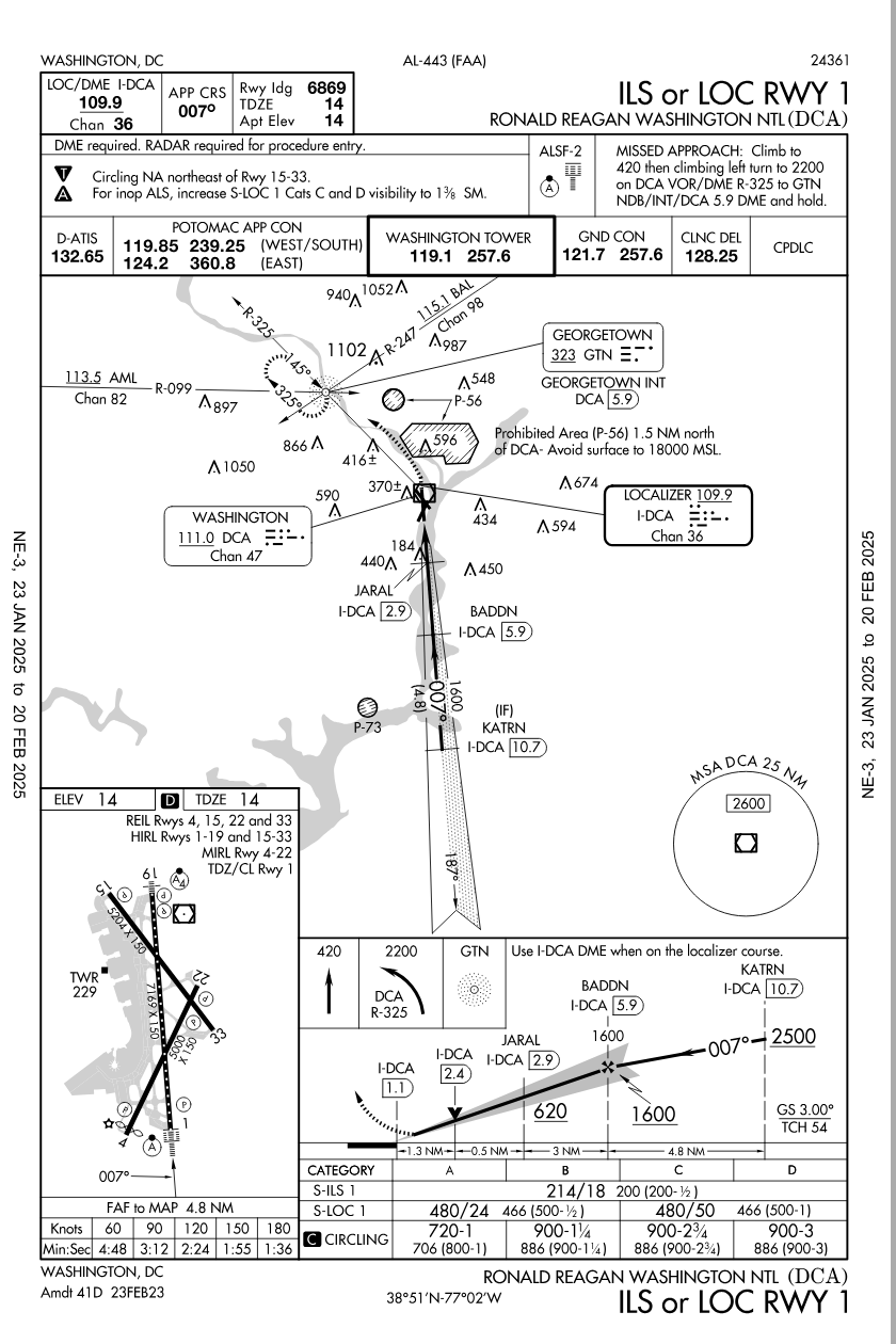
An outdated airport that exists primarily for the benefit of the governing class. Seriously, take a few minutes to look at the approach plates - a circle to land approach to rwy 33, 5,200 ft, at night - really??
A video I watched this morning described the government priority parking spaces, special hotline to the airlines to hold planes for last minute departing bureaucrats. As noted above, for several years the destinations from KDCA were tightly controlled to limit the number of operations, yet this has been compromised by bureaucrats utilizing special privileges to lobby airlines to obtain direct flights to their home cities. After all, it\x92s a far longer drive to KIAD.
Apparently there was some talk years ago to utilize KADW, which is also close to the center of government as a replacement to KDCA, but the neighborhood didn\x92t want the noise.
I think the fact the helo was communicating with the KDCA tower on UHF, (SOP in that area) complicates the SA of all involved. Use of the NVG in the helo with a crew of 3 restricted the SA of the crew. An additional crew member on the helo may have helped.
As mentioned, USA ATC hasn\x92t been up to the usual standards but have some empathy for these folks as staffing levels have significantly degraded and they are being asked to do more with less and I think all aircrew operating in the US are aware of this.
Trumps press conference never should have involved the political aspect, it really degrades the message to the victims families. This is an opportunity to fix the problems in the system, invest money in upgrading staffing levels and equipment and changing poor practices that have been accepted into the norm.
Subjects
ATC
Circle to Land (Deviate to RWY 33)
KDCA
Night Vision Goggles (NVG)
Situational Awareness
Links are to this post in the relevant subject page so that this post can be seen in context.
Reply to this quoting this original post. You need to be logged in. Not available on closed threads.
January 30, 2025, 21:55:00 GMT
permalink Post: 11817682
There's no reason to keep DCA open other than the people like me who lived here found it a convenient and useful airport. That's enough reason. I don't care what you and the other 10 people grasping at straws feel about keeping it open or not. If you don't want to fly here, don't. MYOB.
No, DCA not a miserable experience. IAD, with it's peoplemover (a 60 year old giant bus that you have to board after an 11 hour flight), however is most certainly pure misery.
The reason that KIAD has "plenty of room" is that it's landing and other fees are exorbitant which causing airlines to loathe it, leading to poor flight options and ridiculous prices. Up until 2024, DCA had been literally subsidizing Dulles for decades from their revenue (they're both in the same airport and both are in Virginia.) since customers prefer it. Without the subsidy, prices are just going to get worst.
The operation of DCA is a decision for Virginians (there are no 'DC' airports) It's not some grand political trick to keep it open.
Getting kinda bored with this whole "this whole airspace and DCA facility is a deathtrap" meme. I've been in and out of KDCA and flown at least a thousand hours in the DC FRZ and it's no wild west death trap. stop with the nonsense, please.
Subjects
DCA
KDCA
Links are to this post in the relevant subject page so that this post can be seen in context.
Reply to this quoting this original post. You need to be logged in. Not available on closed threads.
January 30, 2025, 22:14:00 GMT
permalink Post: 11817698
The audio is stitched back together.
But that's why nobody picked up the responses from the Helo crew, despite the LC clearly hearing and getting acks.
Complicating matters in that TRACON is that the military A/C also have their own controller on the assigned frequency. This is probably essential given the comings and goings at the Pentagon and local bases.
Given the track for the helo? It sure appears they expected the aircraft they were waiting on was lined up for 1, not 33. Given this, it is at least possible that they were watching the lights coming from the inbound AC from the Localizer for 1 (a A319 AA plane), not the CRJ descending through their position towards 33.
It's all conjecture, but the use of a separate frequency for the Pentagon-adjacent traffic is cited in several reputable reports as of this AM. Juan Brown's just uploaded an update with further information on the frequency split.
It seems clear from that the the CRJ likely could not hear the Blackhawk. And, with less certainty, that the Blackhawk probably didn't hear transmissions from the CRJ.
Last edited by TachyonID; 30th January 2025 at 23:14 . Reason: Clarify sources for statement about AC on two different frequencies.
Subjects
ATC
Blackhawk (H-60)
CRJ
KDCA
Links are to this post in the relevant subject page so that this post can be seen in context.
Reply to this quoting this original post. You need to be logged in. Not available on closed threads.
January 30, 2025, 23:24:00 GMT
permalink Post: 11817756
The airliner is under IFR rules on its flight plan until it gets changed to a different runway, when it's then VFR.
The chopper is under VFR, stooging along a river at 200 ft and avoiding traffic on approach to Reagan by visual clues alone.
Radar useless as the aircraft are too low.
Airliner TCAS useless as inhibited, even if it can decode the military transponder's data.
Radio situational awareness compromised as chopper on UHF, airliner on VHF. So each aircraft can neither hear the other nor the ATC instructions to that aircraft.
It's difficult to see aircraft at night against a backdrop of a city with thousands of lights. And when you're gonna hit something, as others have said, that light doesn't move relative to you, so you don't notice it - it just blends into the background lights.
It only takes the chopper to misidentify the aircraft it's supposed to go behind and to therefore turn into the path of the airliner it was supposed to avoid - draw the map with the vectors and it all makes sense. These two aircraft ended up in the Potomac, but they could have ended up in much worse places in terms of loss of life on the ground.
Seems to me it's been an accident waiting to happen for some time.
"Radar useless as the aircraft are too low." - It seems there's valid radar returns from both aircraft. the FAA has a good diagram of the Potomac TRACON radar sites, about 10 different radars, and having visited the TRACON several times, they readily explain there's another nearly facility that is a duplicate of their radar feed, but for national security. I assume there's coverage till the river service for security to prevent someone from sneaking up the river with bad ideas
"Radio situational awareness compromised as chopper on UHF, airliner on VHF. " - I fly in the area and in my experience everyone is on the same VHF, they might be also duped to UHF and can hear everybody on my handheld. You hear AF-1 all the time on freq.
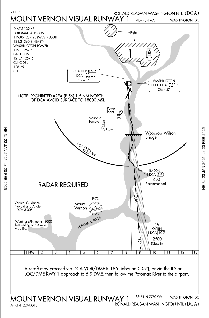
"The chopper is under VFR, stooging along a river at 200 ft and avoiding traffic" - Most of the area NE of the airfield in a prohibited area, and there's a lot of military installations within 5 miles of DC that they are shuttling around, so that path seems perfectly acceptable given the numerous constraints. there's nothing wrong with a helo corridor as long as you stay within it and maintain the prescribed altitude. Also, it's not like KDCA is some secret place, the flight paths are pretty well known if that's where you work. It's popular to sit in parks on both ends and watch the planes, there's literally millions of local people that know exactly the planes are coming and going on both directions. so if you're a helo there, you know where the hot spots are. Likewise, its not just any helo in that area, everyone is vetted, fingerprinted in the inner FRZ.
" on approach to Reagan by visual clues alone" - The UH-60 was not going to DCA, the assumption was it was using the helo route 4 corridor. All the UH-60Ls I've seen have full glass with moving map and I'm assuming a magenta line for the helo corridor.
Fun Fact - Calling it "Reagan" will get you tarred and feathered in the area. Folks refuse to utter the name and for years (decades) the Metro refused to rename the station until legally forced.
Last edited by Senior Pilot; 31st January 2025 at 00:05 . Reason: Prescribed/proscribed
Subjects
ATC
Accident Waiting to Happen
DCA
FAA
Hot Spots
IFR
KDCA
Pass Behind
Pass Behind (All)
Radar
Route 4
Situational Awareness
TCAS (All)
VFR
Links are to this post in the relevant subject page so that this post can be seen in context.
Reply to this quoting this original post. You need to be logged in. Not available on closed threads.
January 31, 2025, 02:45:00 GMT
permalink Post: 11817859
You seem to be pretty sure of that! Well, you know what's so great about the internet gambling boom? , you can get someone to escrow any wager with full faith of both parties ensured? The agreement completely transparent, bonded, and binding. Since your clear that the will of the people of Virginia will be overridden and this is this is going to be shut down as a deathtrap in the next few years, how much do you want to bet that KDCA will remain open in 5 years and operating at the essentially the same capacity ? does US$50k work for you? You're pretty confident that someone is going to ignore what the people who live there want, but just to sweeten it, I'll give you 2:1 odds. Seems like easy money!
Subjects
CRJ
DCA
KDCA
Links are to this post in the relevant subject page so that this post can be seen in context.
Reply to this quoting this original post. You need to be logged in. Not available on closed threads.
January 31, 2025, 13:57:00 GMT
permalink Post: 11818229
As per Google map, the distance from the TDZ to the eastern bank of the Potomac is 1635 m and, with 3.00\xb0 angle, the glide path is supposed to be at an height of 85.5 m, or 280 ft at that point.
Reversely, a height of 500 ft above TDZ is on the glide at a distance of 9540 ft or 2908 m from the TDZ. Google map shows that overhead the northbound lane of I-295.
I think that it's plausible that you aligned your plane with RW33 centerline over the Potomac's East bank if you were flying a steep VFR approach, not a night IFR approach.
Note: 450 ft overhead the eastern bank gives you a 8.4% slope or 4.8\xb0 to the TDZ.
Last edited by Luc Lion; 31st January 2025 at 14:29 . Reason: grammar
Subjects
IFR
KDCA
VFR
Links are to this post in the relevant subject page so that this post can be seen in context.
Reply to this quoting this original post. You need to be logged in. Not available on closed threads.
January 31, 2025, 14:02:00 GMT
permalink Post: 11818235
A minimal response might be to review staffing policies in the tower; if radar equipped it would help to have someone solely responsible for the heli lane situationally aware of inbound traffic to the airport. If more change is acceptable then the heli routes should be examined and probably redesigned and traffic levels at Reagan at least examined.
I can see no reason to close the airport. Yes it is constrained and has short runways but many airports are similar. around the world. London City here is examining whether it can accept Airbus 320 neo aircraft with a 4965 foot runway and steep approaches in a very built up area.
There are wider issues - why do so many controllers sound like disk jockeys in the US whereas here they do their very best to sound calm.
I do believe some changes will come - just as line up and wait was introduced I believe the current clear to land will be replaced by continue approach and then clear to land only where it means that - the runway is clear and I know of no conflict to affect your landing. With this, some clearances still need to be conditional - At KDCA clearance to and 33 might be conditional on 01 traffic. Bit overall it is just clearer - and can be accommodated by most tower controllers given what thy have to deal with AFAICS.
Finally the suitability of see and avoid to night time operations will have to be examined.
Subjects
KDCA
Radar
See and Avoid
Links are to this post in the relevant subject page so that this post can be seen in context.
Reply to this quoting this original post. You need to be logged in. Not available on closed threads.
January 31, 2025, 14:19:00 GMT
permalink Post: 11818246
- but equally describing a fast developing potential collision situation in terms referencing local bridges (was the pilot local ?) is (at least with hindsight) inadequate and something 'far more alarming' could have been said in time.
They probably assume the Army helo pilots know where every tree and rock is.
Subjects
KDCA
Links are to this post in the relevant subject page so that this post can be seen in context.
Reply to this quoting this original post. You need to be logged in. Not available on closed threads.
January 31, 2025, 17:22:00 GMT
permalink Post: 11818389
A minimal response might be to review staffing policies in the tower; if radar equipped it would help to have someone solely responsible for the heli lane situationally aware of inbound traffic to the airport. If more change is acceptable then the heli routes should be examined and probably redesigned and traffic levels at Reagan at least examined.
I can see no reason to close the airport. Yes it is constrained and has short runways but many airports are similar. around the world. London City here is examining whether it can accept Airbus 320 neo aircraft with a 4965 foot runway and steep approaches in a very built up area.
There are wider issues - why do so many controllers sound like disk jockeys in the US whereas here they do their very best to sound calm.
I do believe some changes will come - just as line up and wait was introduced I believe the current clear to land will be replaced by continue approach and then clear to land only where it means that - the runway is clear and I know of no conflict to affect your landing. With this, some clearances still need to be conditional - At KDCA clearance to and 33 might be conditional on 01 traffic. Bit overall it is just clearer - and can be accommodated by most tower controllers given what thy have to deal with AFAICS.
Finally the suitability of see and avoid to night time operations will have to be examined.
Another iootionto make it safe was suggested elsewhere. Have an either/or arrangement.
If an airliner is on approach to runway 33, Heli Route 4 is closed.
If a helicopter has had approval to fly along Route 4, the approach to Runway 33 is not available.
Simple and straightforward?
Last edited by Pilot DAR; 31st January 2025 at 17:24 . Reason: fixed typo
Subjects
KDCA
Radar
Route 4
See and Avoid
Links are to this post in the relevant subject page so that this post can be seen in context.
Reply to this quoting this original post. You need to be logged in. Not available on closed threads.
February 01, 2025, 14:44:00 GMT
permalink Post: 11819064
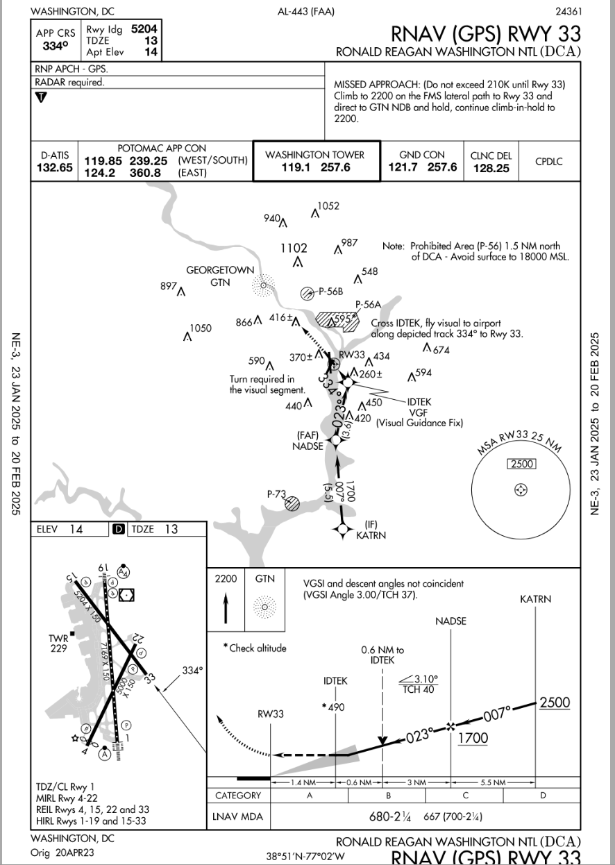
SOP's usually instruct Crews to use ILS data when doing Visual Approaches to runways with that kind of IAP so would that kind of thinking apply in this incident? Would that have been of any benefit considering the existing weather and terrain? Or, would that have been a distraction?
There is a curving RNAV approach, that is not in line with the runway until 490 feet/1.4nm, where one makes the last-minute ~50\xb0 left turn for visual runway alignment.
In light of that fact, maybe you can reframe your question.
AirNav: KDCA - Ronald Reagan Washington National Airport
https://aeronav.faa.gov/d-tpp/2501/00443R33.PDF
Subjects
KDCA
Links are to this post in the relevant subject page so that this post can be seen in context.
Reply to this quoting this original post. You need to be logged in. Not available on closed threads.
February 01, 2025, 17:18:00 GMT
permalink Post: 11819178
There is a curving RNAV approach, that is not in line with the runway until 490 feet/1.4nm, where one makes the last-minute ~50\xb0 left turn for visual runway alignment.
In light of that fact, maybe you can reframe your question.
AirNav: KDCA - Ronald Reagan Washington National Airport
https://aeronav.faa.gov/d-tpp/2501/00443R33.PDF
Now a test question for him.... . were you flying the incident airplane doing a Visual Approach to RWY33....would you have tuned up the IAP for that RWY as an additional reference for your approach ?
SOP's usually instruct Crews to use ILS data when doing Visual Approaches to runways with that kind of IAP so would that kind of thinking apply in this incident? Would that have been of any benefit considering the existing weather and terrain? Or, would that have been a distraction?
Pattern, perhaps you might review your comment.
It really is not a difficult concept or question.
Seems easy enough to understand if the post is actually read for comprehension sakes.
About 80% of all IATA operators would be discomforted by such changes, outside of the USA visual approaches at night have a litany of requirements to adhere to for the purposes of terrain separation, vs Texas big sky rules that do work in the US. In the end, taht didn't cause the accident, it is one of those things that goes with the freedom of flight in the USA.
...
Subjects
ATC
CRJ
KDCA
Separation (ALL)
Links are to this post in the relevant subject page so that this post can be seen in context.
Reply to this quoting this original post. You need to be logged in. Not available on closed threads.
February 02, 2025, 05:06:00 GMT
permalink Post: 11819518
Subjects
KDCA
Links are to this post in the relevant subject page so that this post can be seen in context.
Reply to this quoting this original post. You need to be logged in. Not available on closed threads.
February 02, 2025, 19:56:00 GMT
permalink Post: 11820055
This seems to me to be a big charting oversight, because these charts would be stage centre as any crew conducted their approach briefing and then made reference to them while they flew the actual approach. There\x92s simply nothing on there to suggest risk of mid-air collision might be a factor, where the hotspots are, or extra vigilance required etc.
Subjects
KDCA
VFR
Links are to this post in the relevant subject page so that this post can be seen in context.
Reply to this quoting this original post. You need to be logged in. Not available on closed threads.
February 02, 2025, 21:47:00 GMT
permalink Post: 11820136
from https://asn.flightsafety.org/wikibase/474365
KDCA 300052Z 29015G25KT 10SM CLR 11/M07 A2987 RMK AO2 SLP114 T01061072
Subjects
KDCA
Links are to this post in the relevant subject page so that this post can be seen in context.
Reply to this quoting this original post. You need to be logged in. Not available on closed threads.
February 02, 2025, 21:50:00 GMT
permalink Post: 11820141
SPECI KDCA 300245Z 29007KT 10SM CLR 09/M07 A2993 RMK AO2 ACFT MSHP T00891067=
https://www.ogimet.com/display_metar...f=59&send=send
Subjects
KDCA
Links are to this post in the relevant subject page so that this post can be seen in context.
Reply to this quoting this original post. You need to be logged in. Not available on closed threads.
February 04, 2025, 00:35:00 GMT
permalink Post: 11821049
And the "amateur MLAT" tracking of the helo, is only a rough indication of the trajectory with a wide margin of position error and should be interpreted more like the right side hereunder:
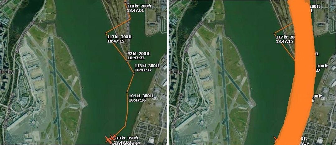
Subjects
CRJ
KDCA
Radar
Route 4
Links are to this post in the relevant subject page so that this post can be seen in context.
Reply to this quoting this original post. You need to be logged in. Not available on closed threads.
February 04, 2025, 13:28:00 GMT
permalink Post: 11821431
And the "amateur MLAT" tracking of the helo, is only a rough indication of the trajectory with a wide margin of position error and should be interpreted more like the right side hereunder:
Thanks for that insight as well.
It's almost as though wearing the NVG in the vicinity of the airport on that evening would, by itself, create a degraded lookout ability. Seems counterintuitive unless one gets into the details of how NVGs work.
Subjects
KDCA
Night Vision Goggles (NVG)
Route 4
Links are to this post in the relevant subject page so that this post can be seen in context.
Reply to this quoting this original post. You need to be logged in. Not available on closed threads.