February 15, 2025, 02:20:00 GMT
permalink Post: 11828339
Vertical and routing wise, the description is pretty detailed.
Personally I think these discussions on the lateral width, or the exact position of the route isn't really relevant. Abeam KDCA for example, I expect not exactly hugging the river bank, but remaining well within the eastern half of the river, wouldn't cause any 'pilot deviation'.
Subjects
KDCA
Links are to this post in the relevant subject page so that this post can be seen in context.
Reply to this quoting this original post. You need to be logged in. Not available on closed threads.
February 16, 2025, 01:54:00 GMT
permalink Post: 11828951
I suppose the operational question is whether the aircraft on which these portable units are used are permitted to fly without them on board and working. My guess is that there will be no prohibition. They are just \x91nice to haves\x92 but not essential for the ops in which they engage.
And there\x92s a causal question anyway: Would a functioning ADS-B system \x96 portable or otherwise - on the PAT helo have made any difference? The answer depends on the variables around the alert suppression parameters in each aircraft\x92s systems and the effectiveness of the format of alerts \x96 if any \x96 given in each cockpit.
Subjects
ADSB (All)
KDCA
Links are to this post in the relevant subject page so that this post can be seen in context.
Reply to this quoting this original post. You need to be logged in. Not available on closed threads.
February 16, 2025, 03:52:00 GMT
permalink Post: 11828969
What they could have seen and heard in the PAT helo depends on a lot on the matters to which I referred, among others, in my earlier post.
Subjects
ADSB (All)
KDCA
Links are to this post in the relevant subject page so that this post can be seen in context.
Reply to this quoting this original post. You need to be logged in. Not available on closed threads.
February 17, 2025, 01:56:00 GMT
permalink Post: 11829588
I’m very much opposed to the helicopter routes, both in planning and execution. The routes shouldn’t exist, if DCA is to remain open. But, to say safety trumps (excuse me) everything is unrealistic. As soon as the wheels leave the runway, there’s risks. This case someone is government accepted too much risk; crews accepted too much risk and normalized that risk. Maneuvering to a different is generally very acceptable, putting a helicopter on final is way too much risk. The system failed to see it for what it was.
Subjects
DCA
KDCA
Links are to this post in the relevant subject page so that this post can be seen in context.
Reply to this quoting this original post. You need to be logged in. Not available on closed threads.
February 17, 2025, 02:19:00 GMT
permalink Post: 11829594
I\x92m very much opposed to the helicopter routes, both in planning and execution. The routes shouldn\x92t exist, if DCA is to remain open. But, to say safety trumps (excuse me) everything is unrealistic. As soon as the wheels leave the runway, there\x92s risks. This case someone is government accepted too much risk; crews accepted too much risk and normalized that risk. Maneuvering to a different is generally very acceptable, putting a helicopter on final is way too much risk. The system failed to see it for what it was.
Subjects
DCA
KDCA
Links are to this post in the relevant subject page so that this post can be seen in context.
Reply to this quoting this original post. You need to be logged in. Not available on closed threads.
February 17, 2025, 06:24:00 GMT
permalink Post: 11829650
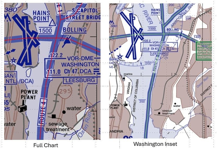
You could reasonably define the bank as the water's edge, and therefore expect crews to fly along an infinitesimally narrow path. Or as the space between the water's edge and the [edge of the flood plain | first flat area | something else], which would imply that the western boundary changes with the water level. Both imply the route is substantially above land.
Neither are useful for precise navigation, but the map and the description are probably 'close enough' if they are only needed for general route guidance and knowing that structures on the east bank need to be NOTAMed for helicopters, but probably not the west bank.
A good reminder that measurements/specifications without tolerance are often worse than useless.
If it quacks like a duck... this kind of "It can't be an X because we can't do it, so we'll call it a Y" leads to a culture that gets used to massaging the truth for convenience. Did we hear more on the Alaska door plug that was an 'opening' not a 'removal'?
Subjects
ATC
CRJ
DCA
FAA
KDCA
NTSB
Night Vision Goggles (NVG)
Pass Behind
Pass Behind (All)
Separation (ALL)
Links are to this post in the relevant subject page so that this post can be seen in context.
Reply to this quoting this original post. You need to be logged in. Not available on closed threads.
February 17, 2025, 09:45:00 GMT
permalink Post: 11829754
So I wouldn\x92t call the altimeter discussion a distraction per se - not yet, anyway. It\x92s just one tiny fact in a complex picture, but still an important fact nevertheless. It is a concrete example of one (or more) of those, by itself insignificant, real-life deviations from perfection occurring. I expect (hope) that the NTSB will use this issue just to illustrate the point that relevant traffic procedures at KDCA were largely based on wishful thinking.
Subjects
Altimeter (All)
KDCA
NTSB
QNH
Links are to this post in the relevant subject page so that this post can be seen in context.
Reply to this quoting this original post. You need to be logged in. Not available on closed threads.
February 20, 2025, 00:01:00 GMT
permalink Post: 11831866
Subjects
ADSB (All)
KDCA
QNH
Links are to this post in the relevant subject page so that this post can be seen in context.
Reply to this quoting this original post. You need to be logged in. Not available on closed threads.
February 20, 2025, 07:51:00 GMT
permalink Post: 11831998
Subjects
ADSB (All)
KDCA
QNH
Links are to this post in the relevant subject page so that this post can be seen in context.
Reply to this quoting this original post. You need to be logged in. Not available on closed threads.
March 11, 2025, 20:08:00 GMT
permalink Post: 11845606
Existing separation distances between helicopter traffic operating on Route 4 and aircraft landing on runway 33 are insufficient and pose an intolerable risk to aviation safety by increasing the chances of a midair collision.
When Route 4 operations are prohibited as recommended in Safety Recommendation A-25-1, it is critical for public safety helicopter operations to have an alternate route for operating in and around Washington, DC, without increasing controller workload.
To the Federal Aviation Administration:
Prohibit operations on helicopter Route 4 between Hains Point and the Wilson Bridge when runways 15 and 33 are being used for departures and arrivals, respectively, at Ronald Reagan Washington National Airport. (A-25-1) (Urgent)
Designate an alternative helicopter route that can be used to facilitate travel between Hains Point and the Wilson Bridge when that segment of Route 4 is closed. (A-25-2) (Urgent)
Subjects
ATC
Findings
KDCA
Route 4
Separation (ALL)
Links are to this post in the relevant subject page so that this post can be seen in context.
Reply to this quoting this original post. You need to be logged in. Not available on closed threads.
March 14, 2025, 03:12:00 GMT
permalink Post: 11847144
One example, after the KBED G IV accident, the NTSB went to the NBAA asking for help in better use of FOQA data increase compliance with flight control checks. Remember, this the G IV crew who tried to take-off with locked controls. ASIAS has tens of thousands of flight control checks and compliance data. Focused on that, measure it, problem mostly solved.
GE Digital’s FOQA programs also have a tremendous data bank. For example, KTEB has an easily the highest rate of TCAS encounters for corporate operators. How it compares to KDCA, I again cannot say. The airlines have the KDCA data for their operations. They know how many and where TCAS events occur. More evidence of normalization, I suppose.
Subjects
Close Calls
FAA
KDCA
NTSB
Normalization of Deviance
TCAS (All)
Links are to this post in the relevant subject page so that this post can be seen in context.
Reply to this quoting this original post. You need to be logged in. Not available on closed threads.
April 22, 2025, 03:15:00 GMT
permalink Post: 11871332
Subjects
ATC
FAA
KDCA
Links are to this post in the relevant subject page so that this post can be seen in context.
Reply to this quoting this original post. You need to be logged in. Not available on closed threads.
May 03, 2025, 19:28:00 GMT
permalink Post: 11877898
U.S.ARMY ATCA-ASO
CAMERON STA
ALEXANDRIA, VA 22314
Subjects
KDCA
PAT23
Links are to this post in the relevant subject page so that this post can be seen in context.
Reply to this quoting this original post. You need to be logged in. Not available on closed threads.
August 01, 2025, 03:53:00 GMT
permalink Post: 11931630
Was it her that later said she'd use baro since the route was MSL not AGL?
Again need to recheck against the transcript. my memory may be fuzzy. I was doing 3 different things at the time.
I have several things I want to revisit from the 2 days so far.

Subjects
KDCA
Links are to this post in the relevant subject page so that this post can be seen in context.
Reply to this quoting this original post. You need to be logged in. Not available on closed threads.
August 15, 2025, 06:37:00 GMT
permalink Post: 11938789
Taking a road procedure similarity : . at a crossroad you can have a stop sign or a triangle giving priority , or nothing
The written procedures are : at a stop sign you must stop even if there is no traffic.
:Transposing this to DCA route 4 map l the procedure should have been in Europe at least ;
1) hold ay golf balls until you get a clearance to proceed . (so that in case of loss of comms , blocked freq, etc.. you can't proceed ).
2) pilot or controller can request visual separation if all t he following conditions re met : typically VMC, and in daylight and traffic is in sight and maintained in sight and both aircrfat pilots are informed. of each other position
3) lateral deviations by the helicopters to fly over built up areas of the city at 200ft will; not be permitted.
Big differences .
Now a pilot can request visual separation at any time but Controller can refuse at any time to .. To my knowledge requesting visual a night using NVG is not covered in the definition of " visual acquisition " in ICAO, so legally it could be challenged I guess . Same as when a pilot reports "visual" on his TCAS display . It is not valid , and for good reasons .
But KDCA is not in Europe, and ICAO SARPs do not apply to military aircrfat , so the outcome of all this is quite uncertain .In fact i would not be surprised if nothing dramatic changes as far as procedures are concerned, Route 4 will be permanently removed I guess, but other than that ? business a usual with visual separations at night ? .
Subjects
ATC
DCA
ICAO
KDCA
Night Vision Goggles (NVG)
Route 4
Separation (ALL)
TCAS (All)
Traffic in Sight
Visual Separation
Links are to this post in the relevant subject page so that this post can be seen in context.
Reply to this quoting this original post. You need to be logged in. Not available on closed threads.
September 30, 2025, 17:13:00 GMT
permalink Post: 11962127
To answer your 2 questions , the fist one is easy , over my nearly 50 years of aviation experience , except recently where we start to discuss seriously Human factors, Fatigue , Mental well being , it was always to blame the Pilots or the controllers first when you can , and protect management and manufacturers was the priority
Al Wiener had even a law for that in the 1980s : .
It you want one , the one I know pretty well is . the Nantes ( France) collision , 2 civil aircrfat under military ATC ) Iberia and Spantax) back in 1973 , at the first trial the Spantax pilot was blamed to protect the military ATC institution , (but overturned in appeal a few years later )
In the US I do not immediately recall any particular involving military ops but there must be some similar to KDCA,, maybe someone has time to run through a proper judicial database .
Subjects
ATC
KDCA
Links are to this post in the relevant subject page so that this post can be seen in context.
Reply to this quoting this original post. You need to be logged in. Not available on closed threads.