February 03, 2025, 22:03:00 GMT
permalink Post: 11820943
Subjects
NTSB
Links are to this post in the relevant subject page so that this post can be seen in context.
Reply to this quoting this original post. You need to be logged in. Not available on closed threads.
February 04, 2025, 15:02:00 GMT
permalink Post: 11821488
remarkable: begin of pitch up 1 sec before impact (CRJ).
Subjects
CRJ
CVR
NTSB
Links are to this post in the relevant subject page so that this post can be seen in context.
Reply to this quoting this original post. You need to be logged in. Not available on closed threads.
February 04, 2025, 15:21:00 GMT
permalink Post: 11821499
https://www.youtube.com/watch?v=-bD-hK3MsiA
remarkable: begin of pitch up 1 sec before impact (CRJ).
Subjects
CRJ
CVR
NTSB
Links are to this post in the relevant subject page so that this post can be seen in context.
Reply to this quoting this original post. You need to be logged in. Not available on closed threads.
February 04, 2025, 22:48:00 GMT
permalink Post: 11821767
to put "all the way" into context, 18 seconds is what they had
Subjects
ADSB (All)
NTSB
TCAS (All)
Links are to this post in the relevant subject page so that this post can be seen in context.
Reply to this quoting this original post. You need to be logged in. Not available on closed threads.
February 05, 2025, 19:16:00 GMT
permalink Post: 11822469
The position of the collision shown in the radar data overlay is consistent with the position of the RJ as shown in ADS-B Exchange at the time of the collision (approximately 01:47:59Z according to the NTSB timeline). See this link from DIBO for the RJ Track with timing AA5342 Down DCA In my experience, times in ADS-B Exchange are generally accurate to within 2 seconds. Given all that, I believe that the Black Hawk was within the horizontal bounds of Route 4 at the time of the collision and that it did not make the right turn we see in the ADS-B Exchange map.
Edit: Corrected route number and helicopter
Last edited by airplanecrazy; 6th February 2025 at 01:24 .
Subjects
AA5342
ADSB (All)
Blackhawk (H-60)
DCA
NTSB
Radar
Route 4
Links are to this post in the relevant subject page so that this post can be seen in context.
Reply to this quoting this original post. You need to be logged in. Not available on closed threads.
February 05, 2025, 19:26:00 GMT
permalink Post: 11822473
Subjects
CRJ
NTSB
Radio Altimeter
Separation (ALL)
Vertical Separation
Links are to this post in the relevant subject page so that this post can be seen in context.
Reply to this quoting this original post. You need to be logged in. Not available on closed threads.
February 06, 2025, 01:54:00 GMT
permalink Post: 11822687
Questions:
Why was PAT 25 search light in the stowed position and not motored to a more forward position?
Why are PAT helicopters not M models with FD's so PAT 25 could have been coupled on route 4 while at 200' giving the PF more time to look for traffic?
Was there pressure to use NVG along route 4 to meet the hourly requirements for currency?
Why did PAT 25 not slow down or hold at Hains in order to pass behind the CRJ as per their clearance?
Why was it ops normal after a near miss the previous day and then only one crew chief instead of two for PAT 25?
Why was the controller task saturated?
Why over the years, as the airport got busier, someone didn't suggest, for night operations, only one aircraft on route 4 or only one aircraft on the approach to 33 at a time and prohibit simultaneous operations?
IMO while the CRJ was turning final to rwy 33 PAT 25 may have experienced the CRJ landing lights in the cockpit and may have chosen up and right rather than left and down. Note worthy, PAT 25 RAD ALT gauge scale changes dramatically at 200'.
Maybe an upgrade to Dulles with a high speed train connection...
Not the latest model? Guess what, combat units get the latest models. These missions are transport, not combat roles. Budgets and priorities rule. There are VH-60s in the battalion, they\x92re probably not scheduled for check rides or training flights.
One RA does not rewrite the schedule, likely not even unusual in DCA. The previous crew may not have passed the event on. I\x92ve had numerous RAs, never a report. The NTSB has stopped asking for reports for events involving VFR traffic.
While nice to have, there\x92s no place for a second crew chief to have a forward view. And the CC may or may not be \x93in the loop\x94. They\x92re crew chiefs, not pilots. We had them on C-5 and they mostly slept in flight as they too much to do on the ground.
Subjects
ATC
CRJ
Close Calls
DCA
NTSB
Night Vision Goggles (NVG)
Pass Behind
Pass Behind (All)
Route 4
TCAS RA
VFR
Links are to this post in the relevant subject page so that this post can be seen in context.
Reply to this quoting this original post. You need to be logged in. Not available on closed threads.
February 06, 2025, 03:31:00 GMT
permalink Post: 11822714
How can you make that statement without realising how many red flags are in it?
LD
Subjects
DCA
NTSB
TCAS RA
VFR
Links are to this post in the relevant subject page so that this post can be seen in context.
Reply to this quoting this original post. You need to be logged in. Not available on closed threads.
February 06, 2025, 21:27:00 GMT
permalink Post: 11823226
The accident investigators will probably be asking questions similar to yours, and a great many more.
As to Dulles and rail: I am happy to inform you that the metro now goes out that far .

I had heard some years ago that the Metro was eventually going to get out that far into Northern Virginia, and it seems that "eventually" has arrived.
[stuff]
But as it was a blatantly political article that did not focus at all on the key things that are pretty much obvious as causal from this discussion, then it is surely just a distraction to serious discussion in this thread.
The controller does not appear to have done anything wrong, so what have DEI policies to do with the ATC side of this accident?
The passenger aircraft followed a procedure and got hit, so what bit of the federal bloat caused that?
The 2-crew helicopter apparently never properly identified the aircraft they were supposed to avoid visually. You going to really argue that the DEI or the government caused that?
Unsafe procedures caused this. SASess, please take the ridiculous politics to Jet Blast.
We all know there are issues with American ATC. But primarily, they are ordinary problems that don't need radical solutions. The solutions are generally more resources and more rigorous enforcement.
* One of my go-to complaints: Pilots not disciplined for erasing or overwriting CVRs following runway incursions and near misses. No blowback for aircrews refusing to meet with NTSB following incursions/near misses. I mentioned this earlier; hopefully 25 hr recorders will fix the overwrite part of this. Ideally the "erase" button would be removed in all cockpits where it still remains. I understand aircrews wanting to erase their CVRs and avoid meetings with investigators after doing something careless (or straight up idiotic) with a plane full of people, but, folks, how can coming to Jesus *not* be part of the job? We are blessed to live in a country where fatal transportation accidents are not presumed to be criminal (unlike most every other non-Commonwealth nation), and aircrews hardly ever have personal liability for damages. Yes a career might take a hit. That's careers for ya.
* Runway incursions in general: Over 1k per year for many years ... we have systems to manage this but they need to be continually funded, resourced, and improved ... HNL, MDW, LAX need to be sorted out aggressively (LAX is no longer the poster child for incursions, good work there, it's HNL now)
* See-and-avoid: It works as well as it does because of the very high standard of air"person"ship prevalent in the US, but it is absolutely guaranteed that see-and-avoid is insufficient to avoid midair collisions, as it is impossible to see all potential collision aircraft even in broad daylight
* Manufacturer quality: Until MCAS I'd have never thought that US manufacturing processes would (once again) become a significant safety risk, but, here we are, with no indication that the trend has been reversed (it's fair to say that there is some promise that there has been a reversal at the top of Boeing management, but effects haven't appeared at this early date)
* ATC hiring: Pay more, hire more, create alternative career structures that allow qualified "old" people in their 30s to start jobs at ATC while giving them a fair framework for retirement
None of this needs "AI" or "satellites" or "complete rework" or "woodchipper" to fix. It just needs money and constant re-commitment to safety, and commitment to compromising in favor of safety when a decision of "revenue vs safety" arises. Honestly I think it's mostly about money. Perhaps 99% about money. Perhaps 100%.
Last edited by remi; 6th February 2025 at 22:31 .
Subjects
ATC
Accountability/Liability
Close Calls
DEI
NTSB
See and Avoid
Links are to this post in the relevant subject page so that this post can be seen in context.
Reply to this quoting this original post. You need to be logged in. Not available on closed threads.
February 07, 2025, 10:20:00 GMT
permalink Post: 11823511
Quite extraordinary for a supposed 'recertification' flight.
Subjects
AA5342
ADSB (All)
NTSB
PAT25
Situational Awareness
TCAS (All)
Links are to this post in the relevant subject page so that this post can be seen in context.
Reply to this quoting this original post. You need to be logged in. Not available on closed threads.
February 07, 2025, 11:01:00 GMT
permalink Post: 11823555
Quite extraordinary for a supposed 'recertification' flight.
In another midair collision report, that happened in July 2022 at NorthLas Vegas airport, NTSB put out this:
Interviews with personnel at the air traffic control tower indicated that staffing was deficient, and most staff were required to work mandatory overtime shifts, reaching an annual average of 400 to 500 hours of overtime per controller. According to the air traffic manager (ATM), the inadequate staffing had resulted in reduced training discissions, and the management team was unable to appropriately monitor employee performance. The ATM stated that everyone on the team was exhausted, and that work/life balance was non-existent. It is likely that the cumulative effects of continued deficient staffing, excessive overtime, reduced training, and inadequate recovery time between shifts took a considerable toll on the control tower workforce.
I wonder, how this situation is with DCA ATC service.
I am not trying to blame ATC either. He issued clearance to PAT25 to cross behind and asked (and got) confirmation for CRJ in sight twice. It seems quite clear that helicopter crew did not look at the same airplane that ATC was asking about.
What baffles me here is, that it was obvious a routine procedure to let helicopters cross active runway heading less than 2 miles from runway treshold, leaving practically zero margin for error. Backups, designed to catch pilots or ATC errors (TCAS and ATC alarms) cannot catch up in short time left if someone makes a mistake, so this arrangement as based on "see and avoid" concept, in the night, with many lights in the background and a fact, that other aircraft on collision course does not move relatively on the screen, but just grows bigger. Unfortunatelly, that dot on the screen that will kill you starts growing bigger only in the last few seconds.
If I would ask ATC to cross runway heading DAY VFR so close to runway treshold at my airport with incoming commercial traffic, I would be denied 100 times out of 100 attempts. (and probably called nuts).
My guess on this tragedy is, that thru the years, the system was trying to pack more and more aircraft in the same space and same infrastructure, by gradually squeezing margins and safegueards, until one day, Jenga tower collapsed.
Subjects
AA5342
ADSB (All)
ATC
Blackhawk (H-60)
CRJ
DCA
NTSB
PAT25
See and Avoid
Situational Awareness
TCAS (All)
VFR
Links are to this post in the relevant subject page so that this post can be seen in context.
Reply to this quoting this original post. You need to be logged in. Not available on closed threads.
February 07, 2025, 11:52:00 GMT
permalink Post: 11823587
Subjects
AA5342
ADSB (All)
CRJ
NTSB
PAT25
TCAS (All)
Links are to this post in the relevant subject page so that this post can be seen in context.
Reply to this quoting this original post. You need to be logged in. Not available on closed threads.
February 07, 2025, 22:36:00 GMT
permalink Post: 11823982
Quite extraordinary for a supposed 'recertification' flight.
The recertification flight might specifically need to be at night. It might even specifically require NVG. I also wonder if both pilots would be on NVG or just one of the two.
Last edited by YRP; 7th February 2025 at 22:49 . Reason: Edited to sound 10% less grumpy
Subjects
AA5342
ADSB (All)
NTSB
Night Vision Goggles (NVG)
PAT25
Situational Awareness
TCAS (All)
Links are to this post in the relevant subject page so that this post can be seen in context.
Reply to this quoting this original post. You need to be logged in. Not available on closed threads.
February 10, 2025, 13:38:00 GMT
permalink Post: 11825508
Update yourself on what the NTSB is reporting.
https://www.ntsb.gov/investigations/...CA25MA108.aspx
Subjects
NTSB
Links are to this post in the relevant subject page so that this post can be seen in context.
Reply to this quoting this original post. You need to be logged in. Not available on closed threads.
February 10, 2025, 20:17:00 GMT
permalink Post: 11825695
The CRJ FDR should allow the NTSB to determine the wind aloft at time of collision.
Subjects
CRJ
DCA
NTSB
Links are to this post in the relevant subject page so that this post can be seen in context.
Reply to this quoting this original post. You need to be logged in. Not available on closed threads.
February 11, 2025, 00:58:00 GMT
permalink Post: 11825797
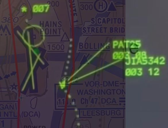
For the ATCO, there wasn't only the flow of arrivals, but a good number of (no delay) departures, all this on intersecting runways and, not shown on the screenshot, in the seconds (a few dozens of...) prior to the accident, the ATCO was handling at least 3 helicopters (Mussel7 / Medevac / PAT25), even not counting the police helicopter working in the SW corner as depicted in the screenshot.
And all this on three* separate frequencies, not fully cross coupled, so TWR was receiving on several occasions, simultaneous/parallel incoming R/T calls (* based on info from other posters in both threads here on pprune & NTSB info - but I still have doubts PAT25 was on UHF, although 3 or 2 freq's, doesn't really matter in this accident's context)
And simulations by VASAviation and the likes, are heavily edited (as they correctly indicate in their comments), so they easily give the impression that traffic and R/T comm's were relatively light...
Subjects
ATCO
NTSB
PAT25
Links are to this post in the relevant subject page so that this post can be seen in context.
Reply to this quoting this original post. You need to be logged in. Not available on closed threads.
February 11, 2025, 06:13:00 GMT
permalink Post: 11825867
On the other hand the collision will have somewhat altered trajectory of both aircraft, so maybe the collision had still occured over land and due to the lateral energy transfer the Helicopter was thrown off its original course towards the West and into the river. We will get this information finally.
And in the end it doesn't really make that much of a difference wrt the level of lunacy of this whole setup.
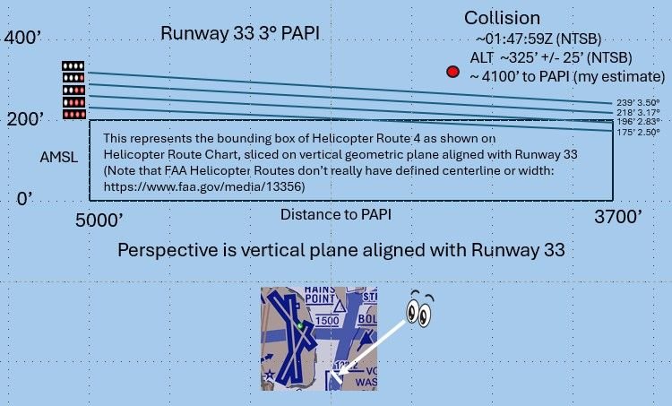
Collision Altitude vs PAPI
Last edited by airplanecrazy; 11th February 2025 at 06:30 . Reason: Problem with picture. Awkward phrasing
Subjects
ADSB (All)
Blackhawk (H-60)
FAA
NTSB
Links are to this post in the relevant subject page so that this post can be seen in context.
Reply to this quoting this original post. You need to be logged in. Not available on closed threads.
February 11, 2025, 07:54:00 GMT
permalink Post: 11825889
And all this on three* separate frequencies, not fully cross coupled, so TWR was receiving on several occasions, simultaneous/parallel incoming R/T calls (* based on info from other posters in both threads here on pprune & NTSB info - but I still have doubts PAT25 was on UHF, although 3 or 2 freq's, doesn't really matter in this accident's context)
And simulations by VASAviation and the likes, are heavily edited (as they correctly indicate in their comments), so they easily give the impression that traffic and R/T comm's were relatively light...
https://www.npr.org/2025/01/30/nx-s1...ntroller-radio
Subjects
ATC
NTSB
PAT25
Links are to this post in the relevant subject page so that this post can be seen in context.
Reply to this quoting this original post. You need to be logged in. Not available on closed threads.
February 11, 2025, 19:28:00 GMT
permalink Post: 11826281
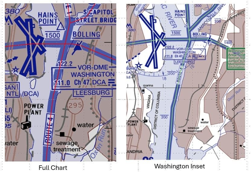
DCA Helicopter Routes
Given these chart differences, I wonder how far a helicopter can stray from the various depictions of a route before it is considered a pilot deviation? Perhaps the NTSB will give us some insight with their accident report.
Last edited by airplanecrazy; 14th February 2025 at 23:53 . Reason: Emphasize the route "appear"
Subjects
DCA
FAA
NTSB
PAT25
Route 4
Separation (ALL)
Visual Separation
Links are to this post in the relevant subject page so that this post can be seen in context.
Reply to this quoting this original post. You need to be logged in. Not available on closed threads.
February 11, 2025, 22:31:00 GMT
permalink Post: 11826358
DCA Helicopter Routes
Given these chart differences, I wonder how far a helicopter can stray from the various depictions of a route before it is considered a pilot deviation? Perhaps the NTSB will give us some insight with their accident report.
"...FAA depicted width of a helicopter route is governed by the following doc: https://www.faa.gov/air_traffic/flight_info/aeronav/iac/media/IAC15/IAC-15-22AUG2022-complete.pdf "
I think that the "width" that you are referring is for the chart maker but not the actual width of a helicopter route.
I can't find in any FAA document a definition of the lateral extent of a helicopter route. Is there one?
There are inconsistencies between the "DESCRIPTION OF ROUTES AND ALTITUDES" and the charts themselves. The Merriam-Webster's 11th Collegiate Dictionary definition of "BANK 2 : the rising ground bordering a lake, river, or sea or forming the edge of a cut or hollow."
for example "RT. 4: ... VIA EAST BANK OF POTOMAC RIVER..." while the chart depicts RT. 4 over the POTOMAC RIVER not over the ground bordering the river.
while "RT. 15: ... ALONG THE WESTERN SHORE OF THE CHESAPEAKE BAY AND PATAPSCO RIVER..." and the chart depicts RT. 15 over water.
Last edited by airman1900; 11th February 2025 at 22:33 . Reason: punctuation and quote
Subjects
DCA
FAA
NTSB
Links are to this post in the relevant subject page so that this post can be seen in context.
Reply to this quoting this original post. You need to be logged in. Not available on closed threads.