February 07, 2025, 04:21:00 GMT
permalink Post: 11823381
Further, seems to me that the helicopter was reporting 200 feet via the IFF (transponder), probably from the AAU-32 Baro altimeter instrument in the cockpit.
.
https://www.reddit.com/r/aircrashinv...radar_sources/
Of course, I think the whole altitude issue is a red herring and the concentration of attention on this "discrepancy" reduces the attention on other issues that aren't as easily "corrected".
Subjects
ATC
Altimeter (All)
PAT25
Links are to this post in the relevant subject page so that this post can be seen in context.
Reply to this quoting this original post. You need to be logged in. Not available on closed threads.
February 07, 2025, 10:20:00 GMT
permalink Post: 11823511
Quite extraordinary for a supposed 'recertification' flight.
Subjects
AA5342
ADSB (All)
NTSB
PAT25
Situational Awareness
TCAS (All)
Links are to this post in the relevant subject page so that this post can be seen in context.
Reply to this quoting this original post. You need to be logged in. Not available on closed threads.
February 07, 2025, 11:01:00 GMT
permalink Post: 11823555
Quite extraordinary for a supposed 'recertification' flight.
In another midair collision report, that happened in July 2022 at NorthLas Vegas airport, NTSB put out this:
Interviews with personnel at the air traffic control tower indicated that staffing was deficient, and most staff were required to work mandatory overtime shifts, reaching an annual average of 400 to 500 hours of overtime per controller. According to the air traffic manager (ATM), the inadequate staffing had resulted in reduced training discissions, and the management team was unable to appropriately monitor employee performance. The ATM stated that everyone on the team was exhausted, and that work/life balance was non-existent. It is likely that the cumulative effects of continued deficient staffing, excessive overtime, reduced training, and inadequate recovery time between shifts took a considerable toll on the control tower workforce.
I wonder, how this situation is with DCA ATC service.
I am not trying to blame ATC either. He issued clearance to PAT25 to cross behind and asked (and got) confirmation for CRJ in sight twice. It seems quite clear that helicopter crew did not look at the same airplane that ATC was asking about.
What baffles me here is, that it was obvious a routine procedure to let helicopters cross active runway heading less than 2 miles from runway treshold, leaving practically zero margin for error. Backups, designed to catch pilots or ATC errors (TCAS and ATC alarms) cannot catch up in short time left if someone makes a mistake, so this arrangement as based on "see and avoid" concept, in the night, with many lights in the background and a fact, that other aircraft on collision course does not move relatively on the screen, but just grows bigger. Unfortunatelly, that dot on the screen that will kill you starts growing bigger only in the last few seconds.
If I would ask ATC to cross runway heading DAY VFR so close to runway treshold at my airport with incoming commercial traffic, I would be denied 100 times out of 100 attempts. (and probably called nuts).
My guess on this tragedy is, that thru the years, the system was trying to pack more and more aircraft in the same space and same infrastructure, by gradually squeezing margins and safegueards, until one day, Jenga tower collapsed.
Subjects
AA5342
ADSB (All)
ATC
Blackhawk (H-60)
CRJ
DCA
NTSB
PAT25
See and Avoid
Situational Awareness
TCAS (All)
VFR
Links are to this post in the relevant subject page so that this post can be seen in context.
Reply to this quoting this original post. You need to be logged in. Not available on closed threads.
February 07, 2025, 11:52:00 GMT
permalink Post: 11823587
Subjects
AA5342
ADSB (All)
CRJ
NTSB
PAT25
TCAS (All)
Links are to this post in the relevant subject page so that this post can be seen in context.
Reply to this quoting this original post. You need to be logged in. Not available on closed threads.
February 07, 2025, 13:24:00 GMT
permalink Post: 11823651
How? considering where they have been at the first briefing about the conflict, just about entering Washington Channel ?
I have learned here:
speed around 90kt min, when orbiting
hovering not a safe option at night over black water (despite lights left and right and everywhere else)
Washington Channel: 200 yards wide
plus golf course and Potomac: less 1 mile wide
runway ends 01 and 15
city to the left with stadions etc.
I really run out of an idea what ATC would clear if the PAT25 crew didnt ask for "visual separation"...
Last edited by 51bravo; 7th February 2025 at 13:42 .
Subjects
ATC
PAT25
Separation (ALL)
Visual Separation
Links are to this post in the relevant subject page so that this post can be seen in context.
Reply to this quoting this original post. You need to be logged in. Not available on closed threads.
February 07, 2025, 14:19:00 GMT
permalink Post: 11823680
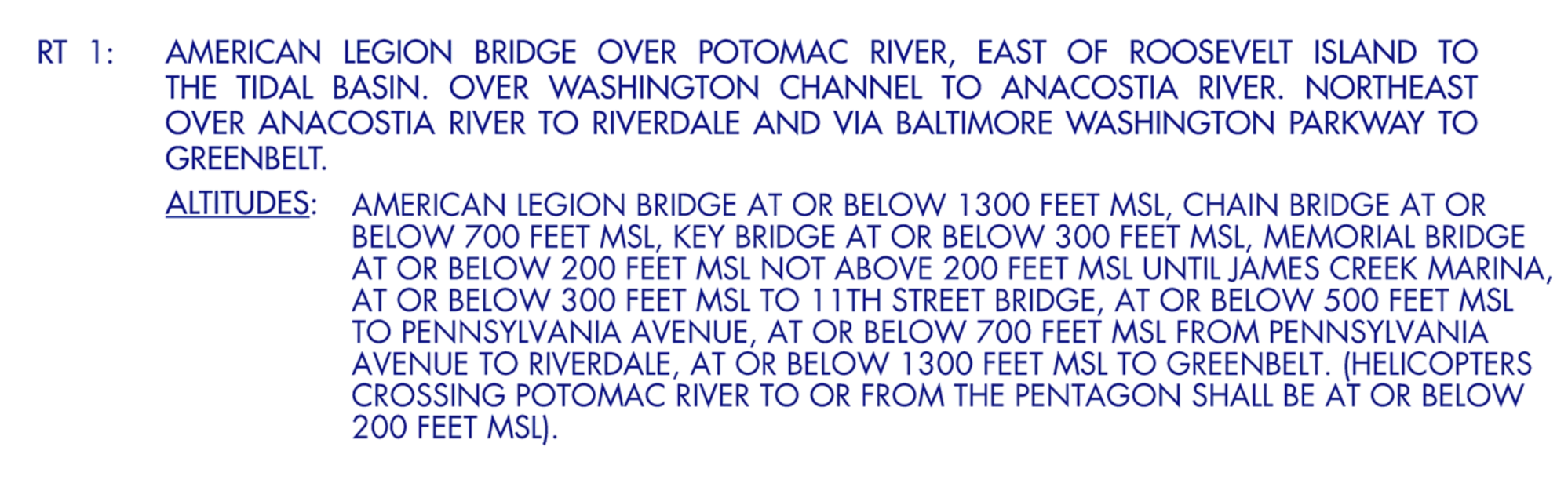
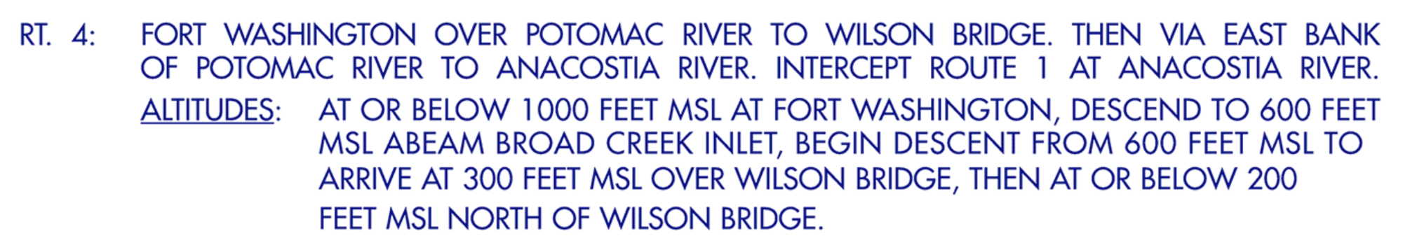
There is also route RT6 from Bolling to Woods Corner, but I don't think that the steep climb from Hains Point 200ft to Bolling 1400ft is reasonable.
Subjects
ATC
PAT25
Separation (ALL)
Visual Separation
Links are to this post in the relevant subject page so that this post can be seen in context.
Reply to this quoting this original post. You need to be logged in. Not available on closed threads.
February 07, 2025, 22:36:00 GMT
permalink Post: 11823982
Quite extraordinary for a supposed 'recertification' flight.
The recertification flight might specifically need to be at night. It might even specifically require NVG. I also wonder if both pilots would be on NVG or just one of the two.
Last edited by YRP; 7th February 2025 at 22:49 . Reason: Edited to sound 10% less grumpy
Subjects
AA5342
ADSB (All)
NTSB
Night Vision Goggles (NVG)
PAT25
Situational Awareness
TCAS (All)
Links are to this post in the relevant subject page so that this post can be seen in context.
Reply to this quoting this original post. You need to be logged in. Not available on closed threads.
February 08, 2025, 01:43:00 GMT
permalink Post: 11824068
The river is 4000 feet wide just south of that designated point. I imagine there is a procedure otherwise what would be the point?
The other option is that they would have to have the landing traffic go around.
Subjects
ATC
PAT25
Separation (ALL)
Visual Separation
Links are to this post in the relevant subject page so that this post can be seen in context.
Reply to this quoting this original post. You need to be logged in. Not available on closed threads.
February 08, 2025, 10:23:00 GMT
permalink Post: 11824232
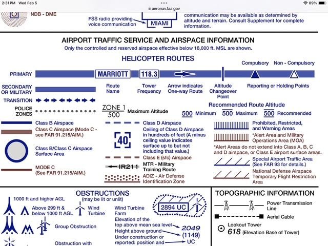
Interesting also that the legend clearly describes the \x93Route Altitudes\x94 as \x93Recommended\x94 (not compulsory), therefore PAT25 being at 300\x92 while not being recommended, was not breaking any rules.
Subjects
PAT25
Links are to this post in the relevant subject page so that this post can be seen in context.
Reply to this quoting this original post. You need to be logged in. Not available on closed threads.
February 08, 2025, 11:26:00 GMT
permalink Post: 11824272
Subjects
PAT25
Links are to this post in the relevant subject page so that this post can be seen in context.
Reply to this quoting this original post. You need to be logged in. Not available on closed threads.
February 10, 2025, 18:56:00 GMT
permalink Post: 11825666
I think many pilots would have made a mistake indentifying : seen from the helo, there are 3 aircraft in final, plus 1 on take-off, at the same bearing, how can you tell for sure which is the one "just south of Wilson Bridge" ?
They could only later identify the correct light spot by following its trajectory according to their mental image of the approach to 33.

At the same time the accident aircraft peels off to the right to swing around and line up to 33, thus taking his (smaller) lights out of the helicopter's direct line of vision and leaving 3130's (brighter) lights still heading to 01 to decoy the pilot. The reflexive nature of the helicopter's responses suggest to me that the full implication of 'circling to 33' in the tower's first call was missed, and also sort of implies that the helicopter could not conceive that following (nearly) the published heliroute could lead him into conflict with an aircraft on final. Me neither.
Last edited by Senior Pilot; 10th February 2025 at 21:22 . Reason: Quote
Subjects
Blackhawk (H-60)
CRJ
DCA
New York Times
PAT25
Separation (ALL)
Visual Separation
Links are to this post in the relevant subject page so that this post can be seen in context.
Reply to this quoting this original post. You need to be logged in. Not available on closed threads.
February 11, 2025, 00:18:00 GMT
permalink Post: 11825784
Subjects
PAT25
Links are to this post in the relevant subject page so that this post can be seen in context.
Reply to this quoting this original post. You need to be logged in. Not available on closed threads.
February 11, 2025, 00:58:00 GMT
permalink Post: 11825797
For the ATCO, there wasn't only the flow of arrivals, but a good number of (no delay) departures, all this on intersecting runways and, not shown on the screenshot, in the seconds (a few dozens of...) prior to the accident, the ATCO was handling at least 3 helicopters (Mussel7 / Medevac / PAT25), even not counting the police helicopter working in the SW corner as depicted in the screenshot.
And all this on three* separate frequencies, not fully cross coupled, so TWR was receiving on several occasions, simultaneous/parallel incoming R/T calls (* based on info from other posters in both threads here on pprune & NTSB info - but I still have doubts PAT25 was on UHF, although 3 or 2 freq's, doesn't really matter in this accident's context)
And simulations by VASAviation and the likes, are heavily edited (as they correctly indicate in their comments), so they easily give the impression that traffic and R/T comm's were relatively light...
Subjects
ATCO
NTSB
PAT25
Links are to this post in the relevant subject page so that this post can be seen in context.
Reply to this quoting this original post. You need to be logged in. Not available on closed threads.
February 11, 2025, 07:54:00 GMT
permalink Post: 11825889
And all this on three* separate frequencies, not fully cross coupled, so TWR was receiving on several occasions, simultaneous/parallel incoming R/T calls (* based on info from other posters in both threads here on pprune & NTSB info - but I still have doubts PAT25 was on UHF, although 3 or 2 freq's, doesn't really matter in this accident's context)
And simulations by VASAviation and the likes, are heavily edited (as they correctly indicate in their comments), so they easily give the impression that traffic and R/T comm's were relatively light...
https://www.npr.org/2025/01/30/nx-s1...ntroller-radio
Subjects
ATC
NTSB
PAT25
Links are to this post in the relevant subject page so that this post can be seen in context.
Reply to this quoting this original post. You need to be logged in. Not available on closed threads.
February 11, 2025, 19:28:00 GMT
permalink Post: 11826281
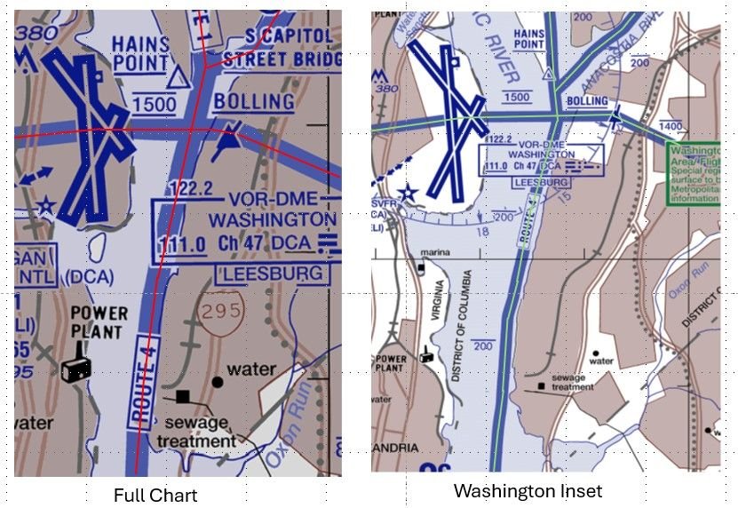
DCA Helicopter Routes
Given these chart differences, I wonder how far a helicopter can stray from the various depictions of a route before it is considered a pilot deviation? Perhaps the NTSB will give us some insight with their accident report.
Last edited by airplanecrazy; 14th February 2025 at 23:53 . Reason: Emphasize the route "appear"
Subjects
DCA
FAA
NTSB
PAT25
Route 4
Separation (ALL)
Visual Separation
Links are to this post in the relevant subject page so that this post can be seen in context.
Reply to this quoting this original post. You need to be logged in. Not available on closed threads.
February 12, 2025, 17:30:00 GMT
permalink Post: 11826835
One ATCO, worked , at three separate frequency, three runways, 6 aircraft for arrival 01, one a/c 33, plus three helicopter, plus how many departures ( both active and approaching/crossing active runways) ?
Plus active estimate for a few aircraft more?
Ground vehicles, any?

Subjects
ATCO
PAT25
Links are to this post in the relevant subject page so that this post can be seen in context.
Reply to this quoting this original post. You need to be logged in. Not available on closed threads.
February 12, 2025, 22:17:00 GMT
permalink Post: 11827015
One ATCO, worked , at three separate frequency, three runways, 6 aircraft for arrival 01, one a/c 33, plus three helicopter, plus how many departures ( both active and approaching/crossing active runways) ?
Plus active estimate for a few aircraft more?
Ground vehicles, any?
Fixed wing
AAL1630, departed 1, waiting handoff to departure
JIA5305, holding short 1, #2
DAL832, holding short 1 #3
JIA5342, cleared to land 33
AAL3130, cleared to land 1
AAL472, cleared visual 1
JIA5347, cleared visual 1, requested 33
Rotary wing
PAT25
helo, Zone 4
helo, callsign Blackjack 1, freq change approved just prior
helo, callsign Muscle 12, handed off to ADW prior
helo, request Route 3, Zone 6
helo, Zone 7
Medevac AirCare helo, proceeding to Inova Fairfax
Some of the helo\x92s on above list may be duplicates due to poor audio quality.
At the time of the accident, runway 4/22 was not in use.
Subjects
ATC
ATCO
PAT25
Links are to this post in the relevant subject page so that this post can be seen in context.
Reply to this quoting this original post. You need to be logged in. Not available on closed threads.
February 14, 2025, 21:03:00 GMT
permalink Post: 11828208

For a couple of days now, was thinking about posting something on an "extra noise" I keep hearing in the R/T comms, when TWR gives the ' pass behind ' instruction. Was wondering whether TWR's Tx wasn't stepped over by someone.
My first impression was that the extra noise came from an radio call from a turbine helicopter (given the typical background noise often heard in radio calls from turbine helicopters). And was wondering if it wasn't PAT25 that started replying to TWR's first ' in sight? ' call, effectively blocking part of TWR's second call, the ' pass behind ' part of the instruction.
In attached mp3 (in .zip per forum attachment requirements) around 00:05 I hear this 'extra noise'.
Edit:
well, this seems to confirm my initial impression:
Last edited by DIBO; 14th February 2025 at 21:07 . Reason: last posts with NTSB info seem to confirm my suspicion
Subjects
ATC
Altimeter (All)
Blackhawk (H-60)
CRJ
CVR
NTSB
PAT25
Pass Behind
Pass Behind (All)
Links are to this post in the relevant subject page so that this post can be seen in context.
Reply to this quoting this original post. You need to be logged in. Not available on closed threads.
February 14, 2025, 23:10:00 GMT
permalink Post: 11828287
...
15:04 parameter is not the primary means the
15:07 pilots would have used to determine
15:08 their height during flight the pilots
15:10 are not typically navigating using radio
15:13 altitude it is often different from what
15:15 they see on their primary Al altimeters
15:18 the next term is barometric altitude
15:21 this is typically the altitude the
15:23 pilots would use while they were flying
Subjects
NTSB
PAT25
Radio Altimeter
Links are to this post in the relevant subject page so that this post can be seen in context.
Reply to this quoting this original post. You need to be logged in. Not available on closed threads.
February 15, 2025, 05:36:00 GMT
permalink Post: 11828365
Last edited by Commando Cody; 15th February 2025 at 07:45 . Reason: precision
Subjects
ATC
CRJ
CVR
PAT25
Pass Behind
Pass Behind (All)
Separation (ALL)
Visual Separation
Links are to this post in the relevant subject page so that this post can be seen in context.
Reply to this quoting this original post. You need to be logged in. Not available on closed threads.