February 02, 2025, 15:44:00 GMT
permalink Post: 11819866
All UH-60 A and L Army aircraft incorporated the APN 209 radar altimeter. Our Sikorsky tech fellow for Avioics/electronis reports the accuracy in this area is 1-2 feet. The radar altimeter position in the instrument panel is just to the right of the attitude indicator and its top matches the top of the attitude indicator. The barometric altimeter is immediately below it.
Both pilots have the same setup.
So unless a very unlikely failures they knew their altitude within a few ft.
Subjects
Altimeter (All)
Barometric Altimeter
Radar
Links are to this post in the relevant subject page so that this post can be seen in context.
Reply to this quoting this original post. You need to be logged in. Not available on closed threads.
February 02, 2025, 16:35:00 GMT
permalink Post: 11819905
But from the beginning, various plots have shown the collision occurring in mid-river. A little work with Google Earth will show that the extended 33 centre line reaches mid-river about 3,300 feet from the aimpoint of runway 33. A 3 degree glideslope and some trig will put it at 175 feet at that range, with obvious implications. 375 feet would be a big error with not much more than half a mile left to run.
What am I doing wrong?
Also, helicopter route 4 hugs the eastern bank of the Potomac until Goose Island and doesn't cross to the western bank until Wilson Bridge. So why did the Black Hawk perform a 45 degree right turn while still abeam DCA? (See, e.g., post #25) Was it intending to route direct to Fort Belvoir, ignoring the heli routes? (I think I've seen it was operating out of Joint Base Anacostia en route to Fort Belvoir, so the fact it was still abeam DCA must have been more than obvious.)
Puzzled.
Assuming the NTSB figure of 375ft is correct, you still need more info for it to mean anything. Was that the AGL, AMSL or SPS height/altitude?
How accurate are the 'various plots' that indicate the collision occurred mid-river? They may be right; they may not be.
Was the CRJ on final or was it still positioning to final? If it wasn't on final then the trigonometric calculations of what height it should be at might not be correct.
What official evidence is there that the Blackhawk made a 45 degree turn, or could that be a data error in the publicly available information?
In summary what I am saying is that, despite all of the internet sleuths plotting tracking data, none of it is official and it is all subject to various errors. Whilst interesting to form an understanding of the circumstances, it can't be assumed to be accurate to within a few feet (vertically or laterally).
All UH-60 A and L Army aircraft incorporated the APN 209 radar altimeter. Our Sikorsky tech fellow for Avioics/electronis reports the accuracy in this area is 1-2 feet. The radar altimeter position in the instrument panel is just to the right of the attitude indicator and its top matches the top of the attitude indicator. The barometric altimeter is immediately below it.
Both pilots have the same setup.
Subjects
ATC
Altimeter (All)
Barometric Altimeter
Blackhawk (H-60)
CRJ
DCA
NTSB
Radar
Radio Altimeter
Route 4
TCAS (All)
Links are to this post in the relevant subject page so that this post can be seen in context.
Reply to this quoting this original post. You need to be logged in. Not available on closed threads.
February 02, 2025, 17:57:00 GMT
permalink Post: 11819965
The reporting made public to date leaves the impression that ATC in this instance is the tower controller and only the tower controller.
Is it possible that radar guidance ( to either party ) has not surfaced because the single tower controller was not ( possibly could not? ) monitoring the tower radar display ( assuming that there was such ).
And, if there was such a display, was there software in place that incorporated a triggered warning when two aircraft tracks predicted an intersection?
NTSB will certainly be looking into these aspects.
( An aside re the barometric altitude accuracy fed to the radar system in the case of the non ADSB helicopter-assume this will be part of the after accident homework? )
Subjects
ADSB (All)
ATC
NTSB
Radar
Links are to this post in the relevant subject page so that this post can be seen in context.
Reply to this quoting this original post. You need to be logged in. Not available on closed threads.
February 02, 2025, 18:42:00 GMT
permalink Post: 11819995
I had my Mil Tower and (DF) Approach ticket at least a year before I went on the GCA Course. OK, it was 1965 and no remote displays in Local, but would I have been legal to use what I could see?
Subjects
ATC
Radar
Separation (ALL)
Links are to this post in the relevant subject page so that this post can be seen in context.
Reply to this quoting this original post. You need to be logged in. Not available on closed threads.
February 02, 2025, 21:03:00 GMT
permalink Post: 11820111
If the aircraft were at a close to 90-degree intersection, then the CRJ700 would have been moving across the field of vision right in front of the helicopter, thus making the collision all the more perplexing, not withstanding night vision goggles (if indeed worn) interfere with depth perception and can reduce field of view to as low as 40\xb0. Of course there also remains the reported disparity in flying height, with the UH-60 100 feet above it's flight ceiling
I can't access the METAR history any more, but I think it was 270V330 with gusts above 20kts. With the helo showing a groundspeed of 80kts on the radar trace, a westerly wind of just 12kts would give 9 degrees of drift and therefore a helo heading of 196, putting the CRJ just outside the 20 degree semi-angle of NVG with 40 degree field of view if the pilots were looking straight ahead.
If anyone can supply the METAR info (there was a report just 10mins after the accident), I'll update my radar diagram with the helo heading and a superimposed field of view. (Edit: done at #729 )
Last edited by Easy Street; 3rd February 2025 at 02:04 .
Subjects
Blackhawk (H-60)
CRJ
Night Vision Goggles (NVG)
Radar
Links are to this post in the relevant subject page so that this post can be seen in context.
Reply to this quoting this original post. You need to be logged in. Not available on closed threads.
February 03, 2025, 01:52:00 GMT
permalink Post: 11820222
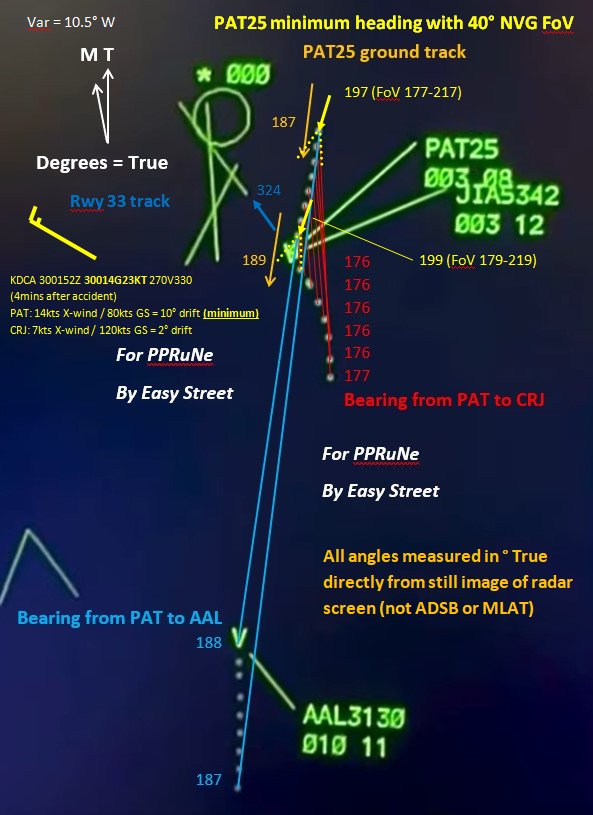
My marked up version of the radar plot now shows the heading of PAT25 at the first and penultimate sweep, based on the ground track as measured directly from the plot and assuming that the wind is at the non-gust value from the METAR observation taken just 4 minutes later (making this a reasonable minimum drift). It also shows the 40 degree field of view of the AN/AVS-9 NVG, drawn assuming both pilots are looking directly ahead along aircraft centreline.
The take-away is that with these assumptions, the CRJ starts on the extreme left hand edge of the NVG field of view and then moves just out of it. The PAT25 pilots would only see the CRJ in NVG if they turned their heads left of aircraft centreline to search for it. Since they thought they had visual contact, presumably with AAL3130, they would have no reason to do so.
Subjects
CRJ
Night Vision Goggles (NVG)
PAT25
Radar
Links are to this post in the relevant subject page so that this post can be seen in context.
Reply to this quoting this original post. You need to be logged in. Not available on closed threads.
February 03, 2025, 03:07:00 GMT
permalink Post: 11820246
And in fact he did speak up, asked the helo to confirm in sight. Obviously he saw it was close and wanted to check.
Unfortunately he didn\x92t quite say enough. If he\x92d said \x93traffic is 1/2 mile\x94 and the helo was looking at something 2 miles away, they might have twigged to it. Maybe.
Subjects
ATC
Radar
Separation (ALL)
Links are to this post in the relevant subject page so that this post can be seen in context.
Reply to this quoting this original post. You need to be logged in. Not available on closed threads.
February 03, 2025, 13:35:00 GMT
permalink Post: 11820540
Subjects
ATC
Radar
Republic Airways Flight 4514 Go-around
Links are to this post in the relevant subject page so that this post can be seen in context.
Reply to this quoting this original post. You need to be logged in. Not available on closed threads.
February 03, 2025, 14:07:00 GMT
permalink Post: 11820561
This was discussed earlier, with several posts being based on listening to an incomplete ATC recording which failed to pick up the (UHF) frequency on which the helicopter crew were responding.
As far as I can see, the helicopter crew when asked twice if they had the CRJ in sight responded in the affirmative both times. I think it's a tad unfair to criticise the controller for not being able to divine that they were actually looking at a different aircraft in the approach sequence.
Subjects
ATC
CRJ
Close Calls
Pass Behind
Pass Behind (All)
Radar
Links are to this post in the relevant subject page so that this post can be seen in context.
Reply to this quoting this original post. You need to be logged in. Not available on closed threads.
February 03, 2025, 14:45:00 GMT
permalink Post: 11820598
But the controller doesn\x92t know they have the wrong plane. Guess: he\x92s just checking they didn\x92t think they\x92d passed it already.
Either way, the controller does not have enough information to use a heading \x97 neither to know one is needed nor what it should be . The radar & display is just not as accurate as a Mark I eyeball in one cockpit seeing the other plane out the window.
When would he? \x93Tower, PAT25 has lost that traffic\x94. Until then a vector might bring them *into* a collision.
Subjects
ATC
CRJ
Close Calls
PAT25
Pass Behind
Pass Behind (All)
Radar
Links are to this post in the relevant subject page so that this post can be seen in context.
Reply to this quoting this original post. You need to be logged in. Not available on closed threads.
February 03, 2025, 15:42:00 GMT
permalink Post: 11820640
(*) I mean control input to maintain visual separation . not last second collision avoidance maneuver.
Subjects
ATC
FAA
ICAO
Radar
Separation (ALL)
VFR
Visual Separation
Links are to this post in the relevant subject page so that this post can be seen in context.
Reply to this quoting this original post. You need to be logged in. Not available on closed threads.
February 03, 2025, 16:32:00 GMT
permalink Post: 11820688
25 ft is the accuracy of mode S, transmit data so let's take 300 ft , Heli was apparently 100 ft higher than its altitude restriction , doing a separation maneuver ? (*) question to my US friends , : when delegating separation VFR to an aircraft does that automatically cancels its previous altitude restrictions ?
(*) I mean control input to maintain visual separation . not last second collision avoidance maneuver.
Subjects
ATC
FAA
ICAO
Radar
Separation (ALL)
VFR
Visual Separation
Links are to this post in the relevant subject page so that this post can be seen in context.
Reply to this quoting this original post. You need to be logged in. Not available on closed threads.
February 03, 2025, 18:43:00 GMT
permalink Post: 11820790
Subjects
ATC
Radar
Links are to this post in the relevant subject page so that this post can be seen in context.
Reply to this quoting this original post. You need to be logged in. Not available on closed threads.
February 03, 2025, 19:05:00 GMT
permalink Post: 11820804
On January 7, 1952, after five years of testing and modifications to a radar system used
by the Army and Navy in World War II, the Civil Aeronautics Administration
inaugurated radar departure control procedures at its Washington National Airport. Six
months later it began radar approach control procedures at the airport.\x94
How do we connect the dots from 1952 to the tragedy described in this thread? 72 years later we have devolved to visual separation.
Subjects
FAA
Radar
Separation (ALL)
Visual Separation
Links are to this post in the relevant subject page so that this post can be seen in context.
Reply to this quoting this original post. You need to be logged in. Not available on closed threads.
February 03, 2025, 20:07:00 GMT
permalink Post: 11820853
A UK Tower/LC can\x92t give headings unless they are radar qualified and current, and have the appropriate equipment.
Subjects
ATC
Radar
Links are to this post in the relevant subject page so that this post can be seen in context.
Reply to this quoting this original post. You need to be logged in. Not available on closed threads.
February 03, 2025, 20:19:00 GMT
permalink Post: 11820865
On January 7, 1952, after five years of testing and modifications to a radar system used
by the Army and Navy in World War II, the Civil Aeronautics Administration
inaugurated radar departure control procedures at its Washington National Airport. Six
months later it began radar approach control procedures at the airport.”
How do we connect the dots from 1952 to the tragedy described in this thread? 72 years later we have devolved to visual separation.
But remember , here the APP radar controllers with the proper ratings and radar tools ( including Conflict alerts) are not in the TWR cab in DC, , they are located in Potomac TRACON , another town , in Warrenton , Virginia ,
.
A UK Tower/LC can’t give headings unless they are radar qualified and current, and have the appropriate equipment.
Last edited by ATC Watcher; 3rd February 2025 at 20:24 . Reason: adding comment to jumpseater post
Subjects
FAA
Radar
Separation (ALL)
Visual Separation
Links are to this post in the relevant subject page so that this post can be seen in context.
Reply to this quoting this original post. You need to be logged in. Not available on closed threads.
February 03, 2025, 20:22:00 GMT
permalink Post: 11820868
My earlier questions remain unanswered … does DCA Tower have a slaved radar display ?
And thus could Tower have used that data to direct PAT21 out of the way, regardless of qualification or licensing? Or did Tower have a Radar qualification anyway, but didn’t use it?
Subjects
ATC
ATCO
DCA
Radar
Links are to this post in the relevant subject page so that this post can be seen in context.
Reply to this quoting this original post. You need to be logged in. Not available on closed threads.
February 03, 2025, 21:07:00 GMT
permalink Post: 11820895
and
.
If you are a controller you know how we work , Problem identified , = Conflict with PT detected , solution found = delegate separation , delegation accepted = problem solved. Next ... The guy was quite busy with departing and arrival traffic in runway one . Now of course with hindsight ,, what he should, and could perhaps have done is very easy for us to say . Feel very sorry for the guy . I hope he is not made the scapegoat for this mess.
Subjects
ATC
DCA
NTSB
Radar
Separation (ALL)
Links are to this post in the relevant subject page so that this post can be seen in context.
Reply to this quoting this original post. You need to be logged in. Not available on closed threads.
February 03, 2025, 21:44:00 GMT
permalink Post: 11820928
My earlier questions remain unanswered \x85 does DCA Tower have a slaved radar display ?
And thus could Tower have used that data to direct PAT21 out of the way, regardless of qualification or licensing? Or did Tower have a Radar qualification anyway, but didn\x92t use it?
Subjects
ATC
ATCO
DCA
Radar
Situational Awareness
Links are to this post in the relevant subject page so that this post can be seen in context.
Reply to this quoting this original post. You need to be logged in. Not available on closed threads.
February 03, 2025, 22:45:00 GMT
permalink Post: 11820974
He\x92s asking the reason to find out what the a/c wants: sequence for another approach, divert due weather, hold to work out a technical fault.
Tower could have passed it on the hotline but it is probably normally more efficient to just have the a/c say.
Working about the safety implication of why the RA and what it says about the procedure is not something for the radio.
Subjects
ATC
Radar
Republic Airways Flight 4514 Go-around
Links are to this post in the relevant subject page so that this post can be seen in context.
Reply to this quoting this original post. You need to be logged in. Not available on closed threads.