February 03, 2025, 23:26:00 GMT
permalink Post: 11821010
Thanks
Subjects
ATC
Blackhawk (H-60)
IFR
Radar
VFR
Links are to this post in the relevant subject page so that this post can be seen in context.
Reply to this quoting this original post. You need to be logged in. Not available on closed threads.
February 03, 2025, 23:43:00 GMT
permalink Post: 11821022
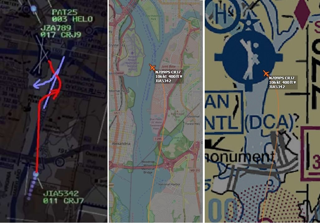
I agree that these are just guesses, but the alternative seems to be that the helo just drifted to the right randomly, for no specific reason, which seems unlikely.
Subjects
CRJ
Radar
Route 4
Separation (ALL)
Links are to this post in the relevant subject page so that this post can be seen in context.
Reply to this quoting this original post. You need to be logged in. Not available on closed threads.
February 04, 2025, 00:35:00 GMT
permalink Post: 11821049
And the "amateur MLAT" tracking of the helo, is only a rough indication of the trajectory with a wide margin of position error and should be interpreted more like the right side hereunder:
Subjects
CRJ
KDCA
Radar
Route 4
Links are to this post in the relevant subject page so that this post can be seen in context.
Reply to this quoting this original post. You need to be logged in. Not available on closed threads.
February 04, 2025, 00:36:00 GMT
permalink Post: 11821050
https://www.youtube.com/shorts/bHBKptJWXtU
I agree that these are just guesses, but the alternative seems to be that the helo just drifted to the right randomly, for no specific reason, which seems unlikely.
Subjects
CRJ
Radar
Route 4
Separation (ALL)
Links are to this post in the relevant subject page so that this post can be seen in context.
Reply to this quoting this original post. You need to be logged in. Not available on closed threads.
February 04, 2025, 01:19:00 GMT
permalink Post: 11821070

And yeah, with the route overlayed on the radar, the deviation from the route doesn't seem to be that great, since the route itself also turns right.
Subjects
Radar
Links are to this post in the relevant subject page so that this post can be seen in context.
Reply to this quoting this original post. You need to be logged in. Not available on closed threads.
February 04, 2025, 10:52:00 GMT
permalink Post: 11821295
Radar orders also need to be given and actions taken sooner than if the crews are doing it of their own initiative. So a radar CA needs to be visible say 15 second pre-collision so ATC can wait for the radio to be clear then order pilots to manoeuvre. Pilots can aim to cross visually at more like 5 seconds.
I'm not saying that this is overall a good idea, but the fundamental reason you fit more planes in with visual separation is that you can put them closer together with (given good visibility) not too dissimilar safety.
[Edit: too late... Fullwings got this.]
TCAS 8 is getting closer and sooner after this horrific accident.
Subjects
ATC
Blackhawk (H-60)
CRJ
DCA
Radar
Separation (ALL)
TCAS (All)
TCAS RA
Visual Separation
Links are to this post in the relevant subject page so that this post can be seen in context.
Reply to this quoting this original post. You need to be logged in. Not available on closed threads.
February 04, 2025, 10:57:00 GMT
permalink Post: 11821301
Thanks
Issue a safety alert to an aircraft if you are aware the aircraft is in a position/altitude that, in your judgment, places it in unsafe proximity to terrain, obstructions, or other aircraft. Once the pilot informs you action is being taken to resolve the situation, you may discontinue the issuance of further alerts. Do not assume that because someone else has responsibility for the aircraft that the unsafe situation has been observed and the safety alert issued; inform the appropriate controller.
NOTE-
1. The issuance of a safety alert is a first priority (see paragraph 2-1-2, Duty Priority) once the controller observes and recognizes a situation of unsafe aircraft proximity to terrain, obstacles, or other aircraft. Conditions, such as workload, traffic volume, the quality/limitations of the radar system, and the available lead time to react are factors in determining whether it is reasonable for the controller to observe and recognize such situations. While a controller cannot see immediately the development of every situation where a safety alert must be issued, the controller must remain vigilant for such situations and issue a safety alert when the situation is recognized.
Recognition of situations of unsafe proximity may result from MSAW/E-MSAW, automatic altitude readouts, Conflict/Mode C Intruder Alert, observations on a PAR scope, or pilot reports.
Once the alert is issued, it is solely the pilot's prerogative to determine what course of action, if any, will be taken.
...
b. Aircraft Conflict/Mode C Intruder Alert. Immediately issue/initiate an alert to an aircraft if you are aware of another aircraft at an altitude that you believe places them in unsafe proximity. If feasible, offer the pilot an alternate course of action. When an alternate course of action is given, end the transmission with the word \x93immediately.\x94
PHRASEOLOGY-
TRAFFIC ALERT (call sign) (position of aircraft) ADVISE YOU TURN LEFT/RIGHT (heading),
and/or
CLIMB/DESCEND (specific altitude if appropriate) IMMEDIATELY.
EXAMPLE-
\x93Traffic Alert, Cessna Three Four Juliett, 12'o clock, 1 mile advise you turn left immediately.\x94
or
\x93Traffic Alert, Cessna Three-Four Juliett, 12'o clock, 1 mile advise you turn left and climb immediately.\x94
Subjects
ALERT Act of 2026
ATC
Blackhawk (H-60)
Radar
Links are to this post in the relevant subject page so that this post can be seen in context.
Reply to this quoting this original post. You need to be logged in. Not available on closed threads.
February 04, 2025, 11:44:00 GMT
permalink Post: 11821332
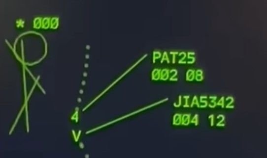
CA will activate whenever certain separation minima are going to be lost (600\x92 and 2 miles for example).
Visual separation is a perfectly legal tool that allows separation to reduce below radar minima.
CA will (almost) always activate when applying visual separation. That doesn\x92t mean the aircraft are on a collision course or are definitely going to crash, it just means they will be in confliction and separated by less than the IFR radar minima.
Its activation in this scenario (and countless others in the days before) was totally normal. Anyone who thinks it should have been reacted to differently or that it was a last line of defence really doesn\x92t understand the role of Conflict Alert.
And it\x92s not the role of the radar centre to phone tower and warn them of a conflict alert between two aircraft they would expect to be visually separated - that\x92s a scenario that probably happens several times a day.
Subjects
IFR
Radar
Separation (ALL)
Visual Separation
Links are to this post in the relevant subject page so that this post can be seen in context.
Reply to this quoting this original post. You need to be logged in. Not available on closed threads.
February 04, 2025, 23:36:00 GMT
permalink Post: 11821805
Subjects
Radar
Links are to this post in the relevant subject page so that this post can be seen in context.
Reply to this quoting this original post. You need to be logged in. Not available on closed threads.
February 04, 2025, 23:53:00 GMT
permalink Post: 11821816
Subjects
Radar
Links are to this post in the relevant subject page so that this post can be seen in context.
Reply to this quoting this original post. You need to be logged in. Not available on closed threads.
February 05, 2025, 00:05:00 GMT
permalink Post: 11821822
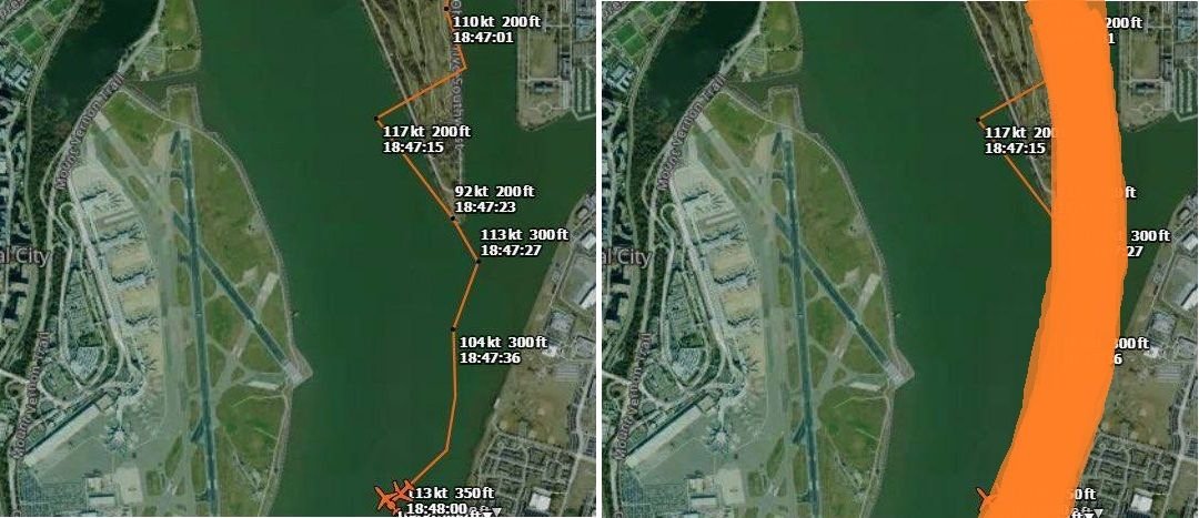
I think the confusion comes from the "amateur MLAT" tracking, which calculates the GS based on the multilaterated position calculations, which have a (relatively) large margin of error:
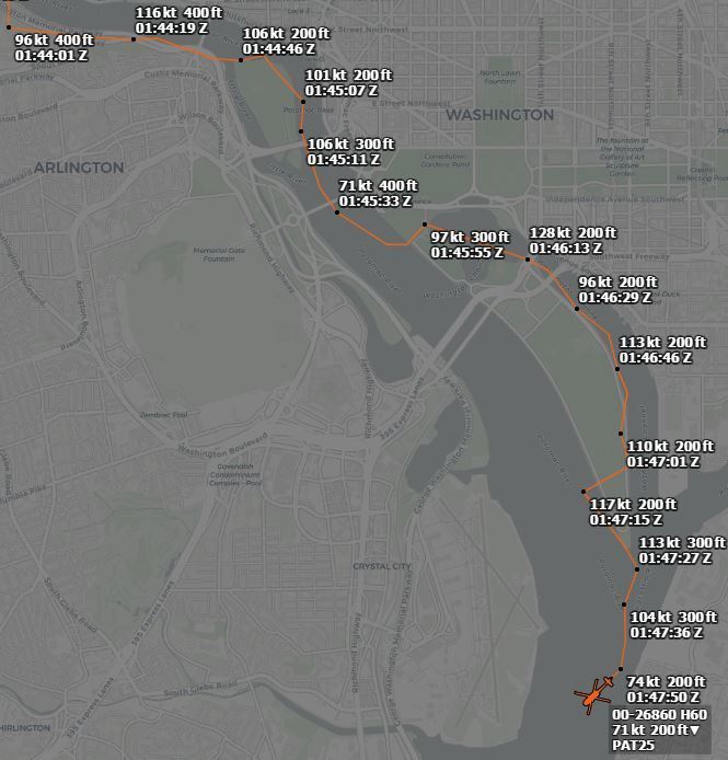
And probably PAT25 was doing initially something in the region of 100kts GS (edit: averaging all but last calculated GS, gives 105kts as average - and over more datapoints, longer trajectory, calculated average GS becomes more reliable)
but at the end it seems there might possibly have been a decreasing GS trend:
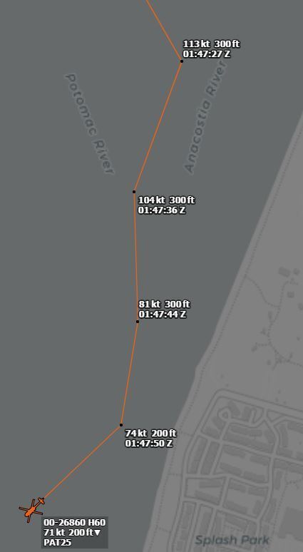
Last edited by DIBO; 5th February 2025 at 00:10 . Reason: added calculated average GS
Subjects
ADSB (All)
CRJ
PAT25
Radar
Links are to this post in the relevant subject page so that this post can be seen in context.
Reply to this quoting this original post. You need to be logged in. Not available on closed threads.
February 05, 2025, 11:21:00 GMT
permalink Post: 11822123
Usually, only if crossing LHR you'd be cleared to enter via requested route with limit Bedfont/Sipson, sometimes Airport Spur to hold (orbit) and change from Heathrow Special to Tower for the crossing itself. There's a further hold at Twin Taxiways between the runways. Altitudes are shown. Note there is usually unrestricted passage on routes H3 and H10 along the river directly under the approach. This system works seamlessly and with - to date - total safety.
Accepted the aairport we are discussing has more varied runway directions than Heathrow so the situation would be a bit more complex but I can't see why a similar system couldn't be devised - with defined clearance limits, sensible vertical separation and, critically, coherent and specific controller voice procedure.
There's no reason not to make landing traffic aware of helos holding close in if appropriate and indeed that happens, but no way is their visual contact required.
The entire system operates on visual 'separation'. Helos cross visually behind traffic as cleared, but with vertical separation. It's as safe as the system can be made. How else could it work? It requires no controller vectoring and the time and space margins that would be required if radar separation was used would render the slick, efficient visual system cumbrous, unacceptably high end unnecessary workload and probably unworkable.
Please, once again let's stop applying this insular f/w procedural IFR mindset to VFR helo traffic. There seems to be a procedural IFR mental blockage that can't see that 'visual separation' occurs in three dimensions, not just two. Helos are perfectly capable of ensuring visual separation as long as the traffic has been correctly identified and with vertical separation as here even if a mistake is made there is 800ft clear vertically. Also, VFR does NOT mean, as many seem to imagine, blundering about randomly at will, it is often every bit as disciplined and controlled as IFR as Shackman reiterates below, these routes are rigidly enforced to within a hundred metres or so and woe betide the transgressor.
The elephant in the room here is a combintion of a ridiculously hazardous two-dimensional crossing procedure combined with culpably sloppy & imprecise r/t which offers no second slice of cheese, not matters of visual separation. I'm well aware that our transatlantic cousins are sensitive to criticism of their relaxed, easygoing and informal ways in the air but in this case they self-evidently were the direct cause of 70 odd deaths. While they may regard European style as excessively pedantic there's no doubt whatsoever that had European standards applied here this event would have resulted in nothing more serious than a MOR and an Airmiss report.
For those unfamiliar the light grid squares are 1Km so the Sipson and Bedfont reporting/holding points is ony about 500m from the runways.
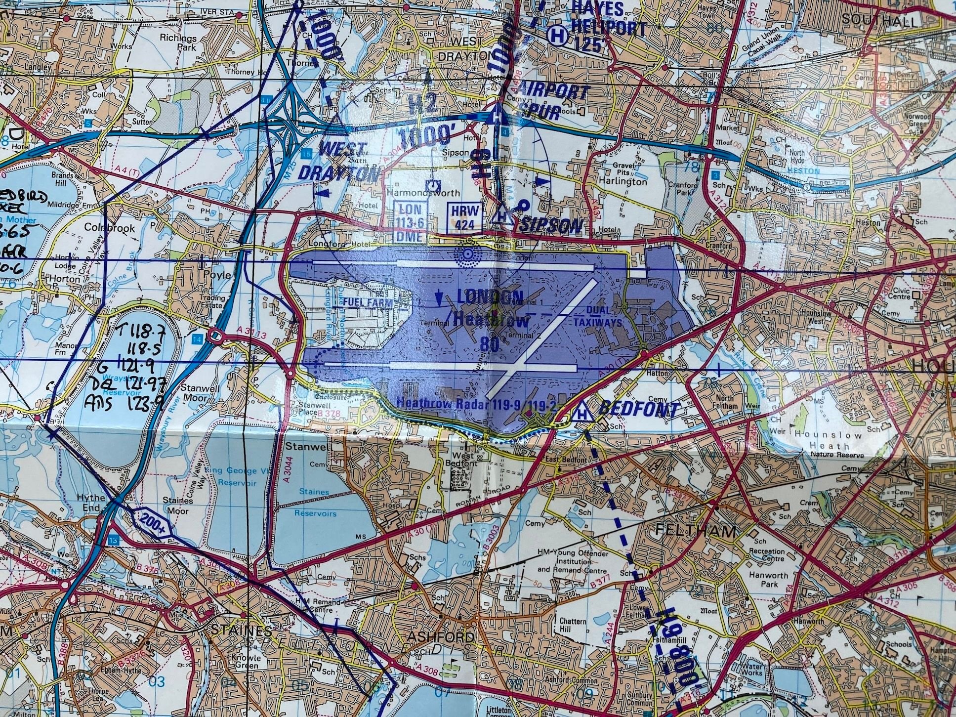
Last edited by meleagertoo; 5th February 2025 at 12:23 .
Subjects
ATC
IFR
Radar
Separation (ALL)
VFR
Vertical Separation
Visual Separation
Links are to this post in the relevant subject page so that this post can be seen in context.
Reply to this quoting this original post. You need to be logged in. Not available on closed threads.
February 05, 2025, 11:38:00 GMT
permalink Post: 11822133
Subjects
Radar
Links are to this post in the relevant subject page so that this post can be seen in context.
Reply to this quoting this original post. You need to be logged in. Not available on closed threads.
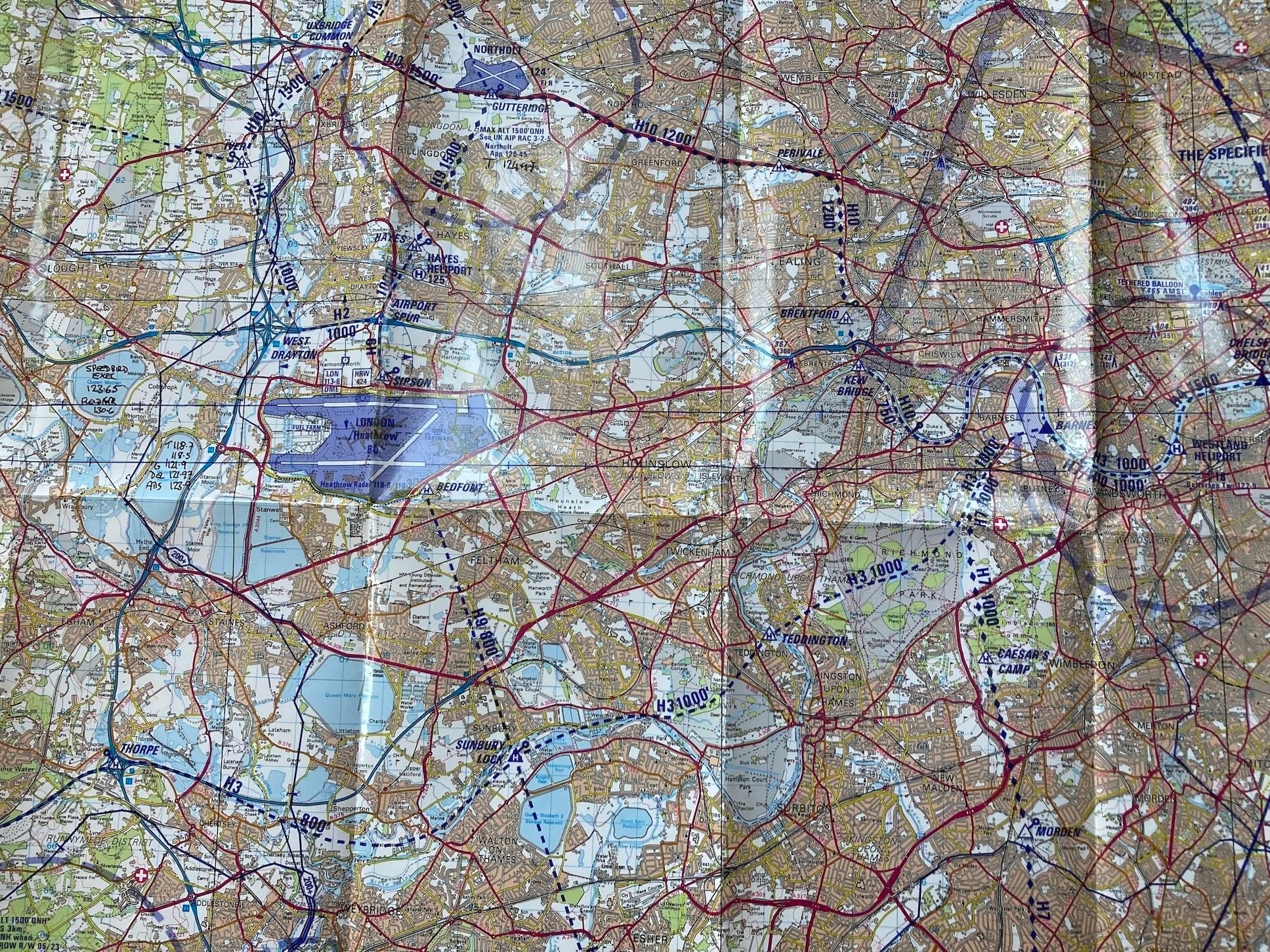
February 05, 2025, 12:57:00 GMT
permalink Post: 11822202
...change from Heathrow Special to Tower for the crossing itself. There's a further hold at Twin Taxiways between the runways. Altitudes are shown. Note there is usually unrestricted passage on routes H3 and H10 along the river directly under the approach...
...defined clearance limits, sensible vertical separation and, critically, coherent and specific controller voice procedure.
I agree with your underlying point that blanket application of IFR separation criteria would be inappropriate. But there are modes of separation besides the false binary of 'visual' and 'IFR' which can be applied to VFR traffic.
Last edited by Easy Street; 5th February 2025 at 14:01 .
Subjects
ATC
IFR
Radar
Separation (ALL)
VFR
Vertical Separation
Visual Separation
Links are to this post in the relevant subject page so that this post can be seen in context.
Reply to this quoting this original post. You need to be logged in. Not available on closed threads.
February 05, 2025, 19:16:00 GMT
permalink Post: 11822469
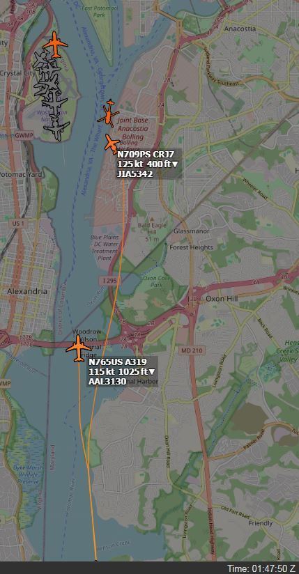
The position of the collision shown in the radar data overlay is consistent with the position of the RJ as shown in ADS-B Exchange at the time of the collision (approximately 01:47:59Z according to the NTSB timeline). See this link from DIBO for the RJ Track with timing AA5342 Down DCA In my experience, times in ADS-B Exchange are generally accurate to within 2 seconds. Given all that, I believe that the Black Hawk was within the horizontal bounds of Route 4 at the time of the collision and that it did not make the right turn we see in the ADS-B Exchange map.
Edit: Corrected route number and helicopter
Last edited by airplanecrazy; 6th February 2025 at 01:24 .
Subjects
AA5342
ADSB (All)
Blackhawk (H-60)
DCA
NTSB
Radar
Route 4
Links are to this post in the relevant subject page so that this post can be seen in context.
Reply to this quoting this original post. You need to be logged in. Not available on closed threads.
February 07, 2025, 00:09:00 GMT
permalink Post: 11823328
Did the FAA or the Army assume they would always be able to apply visual (NOT VFR) separation. Visual separation does not necessarily mean 500\x92 vertically and 1.5 nm or radar target separation; it means \x93I see you, I miss you\x94. Did the operating plan always direct crews to use visual separation as the default plan? I hope not, but it is only I see it being written.
Subjects
FAA
IFR
Radar
Route 4
Separation (ALL)
VFR
Visual Separation
Links are to this post in the relevant subject page so that this post can be seen in context.
Reply to this quoting this original post. You need to be logged in. Not available on closed threads.
February 07, 2025, 12:37:00 GMT
permalink Post: 11823616
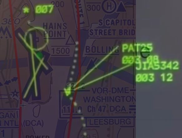
1.5NM is obviously not applied, look at the south flow arrivals TCAS RA the day prior. It, a PAT merged previously with a SWA 737 at TCAS TA altitudes with Collision Alert to ATC radar, before causing the later RA.
Last edited by moosepileit; 7th February 2025 at 15:53 .
Subjects
ATC
Radar
Separation (ALL)
TCAS (All)
TCAS RA
Links are to this post in the relevant subject page so that this post can be seen in context.
Reply to this quoting this original post. You need to be logged in. Not available on closed threads.
February 07, 2025, 14:42:00 GMT
permalink Post: 11823692
And, oh-forgot to mention: if one ignores the radar controller’s instruction to hold, said helicopter is met by the law ( least-thats what happened to a guy I was following in Paris, who blatantly ignored a hold command at Bagnolet. By the time I arrived at the Le Bourget helipad his ship was surrounded by gendarmes and a black van.
Last edited by JohnDixson; 7th February 2025 at 14:52 . Reason: added info
Subjects
Radar
Links are to this post in the relevant subject page so that this post can be seen in context.
Reply to this quoting this original post. You need to be logged in. Not available on closed threads.
February 07, 2025, 17:33:00 GMT
permalink Post: 11823798
Subjects
Radar
Links are to this post in the relevant subject page so that this post can be seen in context.
Reply to this quoting this original post. You need to be logged in. Not available on closed threads.
February 07, 2025, 18:03:00 GMT
permalink Post: 11823821
Subjects
Radar
Links are to this post in the relevant subject page so that this post can be seen in context.
Reply to this quoting this original post. You need to be logged in. Not available on closed threads.