February 10, 2025, 13:56:00 GMT
permalink Post: 11825521
https://www.avweb.com/flight-safety/tower-brites/
This explains the different phraseology between a tower using a BRITE to help out vs. the phraseology of tower certified and equipped for full radar separation. It also explains LOAs for airspace. Where I learned to fly at KMLB the tower only owned up to about 1800 feet IIRC and approach had above that. In those pre-BRITE days it helped a lot for handling IFR traffic.
( I sometimes flew a Bell 47 helicopter there and the tower managed to organize it such that I never came close to any airplanes)
Subjects
IFR
Phraseology (ATC)
Radar
Separation (ALL)
Links are to this post in the relevant subject page so that this post can be seen in context.
Reply to this quoting this original post. You need to be logged in. Not available on closed threads.
February 11, 2025, 09:56:00 GMT
permalink Post: 11825962
Speculation : The helicopter crews know that if they don't report traffic in sight as soon as it's called, they'll be slowed down and deprioritised by ATC and eventually held back until they either do report the traffic, or there's a substantial gap in arrivals - see the LH A380. That makes them unpopular with their passengers and/or superiors, so they are very flexible with what 'in sight' means.
ATC likewise knows that if they push helicopter crews too hard on altitude busts, report anything involving a helicopter, or hold up either kind of traffic, they might get people breathing down their neck and certainly nothing good comes of it.
Calling traffic immediately and not enforcing separation too strictly allows both parties to 'get on with their jobs' while looking more-or-less by-the-book - until an incident like this happens.
I'm hopeful I'm wrong, but given there seems to be a long history of near misses and altitude busts this seems like the obvious conclusion. No-one high-up wanted to hear about it or change anything , because no-one had died yet.
On a slightly different note, I'm curious whether anyone is familiar with the Hierarchy of Controls by NIOSH? It doesn't map 1:1 to aviation, but it codifies some things that are 'obvious' in hindsight:
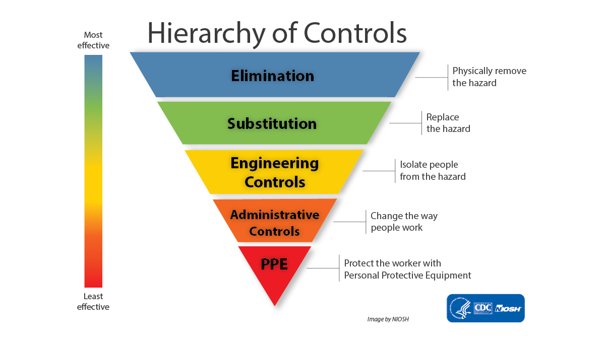
Broadly speaking, some controls are more effective than others. Wherever possible, you should attempt to use more effective controls in place of less effective ones. More effective means not just that it reduces the risk the most, but also the most reliable over time and most resistant to having rules bent, being left broken, being ignored due to alarm fatigue, or 'normalisation of deviation'. Procedures that assume everything is working perfectly and everyone is 100% competent will fail; see MCAS and a great number of other accidents.
Elimination is rarely possible but substitution (radar vs visual) and isolation (separate helicopters from other traffic) amongst other engineering controls are potentially more feasible, and much higher up the hierarchy than a glorified instruction not to crash (the very bottom of administrative). Engineering a problem out of existence is far superior to having a procedure to fix it in the QRH.
I list things like TCAS, GPWS, RSAs, and crash-proof seating as broadly being under PPE: they're nice to have and certainly worth pursuing, but unless there is no other alternative, they should never be your primary protection. Something has gone wrong if they get used.
Subjects
ATC
Close Calls
Normalization of Deviance
Radar
Separation (ALL)
TCAS (All)
Traffic in Sight
Links are to this post in the relevant subject page so that this post can be seen in context.
Reply to this quoting this original post. You need to be logged in. Not available on closed threads.
February 13, 2025, 01:33:00 GMT
permalink Post: 11827083
That is just one factor in this sad affair of course. Both TCAS and STCA are last ditch saviours but only if full attention can be paid to them.
TCAS RA says that a collision is imminent (within the accuracy of the system, ie it probably means the system can\x92t prove the planes won\x92t hit).
Conflict alert is to notify the controller well in advance \x97 maybe a few minutes for en-route. It isn\x92t a loss of separation, it is so they can avoid a loss of separation (3 or 5 miles for radar).
Subjects
ATC
Radar
Separation (ALL)
TCAS (All)
TCAS RA
Links are to this post in the relevant subject page so that this post can be seen in context.
Reply to this quoting this original post. You need to be logged in. Not available on closed threads.
February 13, 2025, 10:16:00 GMT
permalink Post: 11827259
TCAS RA says that a collision is imminent (within the accuracy of the system, ie it probably means the system can\x92t prove the planes won\x92t hit).
Conflict alert is to notify the controller well in advance \x97 maybe a few minutes for en-route. It isn\x92t a loss of separation, it is so they can avoid a loss of separation (3 or 5 miles for radar).
The problem with conflict alerting is that in mixed-use airspace you will get a lot of warnings; I hesitate to say false as they are defined by preset parameters that may or may not be relevant to the potential conflict. Talking to controllers in the UK, they often turn this feature (STCA) off as GA traffic happily avoiding each other by visual and/or electronic means can fill the screen with so many alerts it distracts from the main job, especially if you are not in communication with either aircraft.
I would expect, given the traffic density around DCA, that CAs are so commonplace they have become unremarkable, indeed expected. Twice the controller was told that the traffic was in sight, so in their mind they are applying visual separation (no minima, just don\x92t collide). The takeaway has to be that IFR/VFR separation at night by visual means is inherently risky and so a questionable pursuit.
Subjects
ATC
DCA
Radar
Separation (ALL)
TCAS (All)
TCAS RA
Traffic in Sight
Visual Separation
Links are to this post in the relevant subject page so that this post can be seen in context.
Reply to this quoting this original post. You need to be logged in. Not available on closed threads.
February 15, 2025, 10:10:00 GMT
permalink Post: 11828480
Disconcerting that the PAT 25 crew, about to descend and fly less than 200 feet AGL , would not have investigate the discrepancy of 100 feet between their respective altimeters...
Subjects
Altimeter (All)
Radar
Links are to this post in the relevant subject page so that this post can be seen in context.
Reply to this quoting this original post. You need to be logged in. Not available on closed threads.
February 15, 2025, 10:24:00 GMT
permalink Post: 11828489
I sincerely hope the NTSB can avoid being distracted by the distractions of altimetry and the missing ATC words on the Blackhawk CVR.
Upthread, Luca Lion calculated the 3 degree PAPI approach path as crossing the eastern riverbank at 270ft. If that's correct, then the CRJ's 313ft radar height 2 seconds before collision puts it at least 43ft above the approach path, so the Blackhawk's radio height deviation of 78ft would have contributed only about 35ft to the erosion of any intended "procedural separation" (*) between the aircraft. Or, to put it another way, the same outcome would have resulted if the Blackhawk had been at 235ft radio and the CRJ on the glide. Height keeping of plus or minus 35ft can only be achieved by instrument flying, which is obviously not compatible with visual separation (or indeed VFR) so cannot be reasonably cited as part of a safety case for the procedure. And of course a landing aircraft could easily be below the glide. Altimetry and height keeping are not the cause of this accident.
Missing the word "circling" wouldn't have influenced the helo crew getting visual with the CRJ at the time of the trasnmission. At best, it would have given them an extra nudge that "runway 33" (which was audible) meant the CRJ would be taking an easterly flight path. Missing "pass behind" with only a few seconds to collision was irrelevant if, as seems likely, the helo crew did not see the CRJ at that point.
(*) The quotes around "procedural separation" are intended to convey a tone of disgust and sarcasm.
Last edited by Easy Street; 15th February 2025 at 10:47 .
Subjects
ATC
Altimeter (All)
Blackhawk (H-60)
CRJ
CVR
Final Report
NTSB
Pass Behind
Pass Behind (All)
Radar
Separation (ALL)
VFR
Visual Separation
Links are to this post in the relevant subject page so that this post can be seen in context.
Reply to this quoting this original post. You need to be logged in. Not available on closed threads.
February 15, 2025, 10:55:00 GMT
permalink Post: 11828510
I sincerely hope the NTSB can avoid being distracted by the distractions of altimetry and the missing ATC words on the Blackhawk CVR.
Upthread, Luca Lion calculated the 3 degree PAPI approach path as crossing the eastern riverbank at 270ft. If that's correct, then the CRJ's 313ft radar height 2 seconds before collision puts it at least 43ft above the approach path, so the Blackhawk's radio height deviation of 78ft would have contributed only about 35ft to the erosion of any intended "procedural separation" (*) between the aircraft. Or, to put it another way, the same outcome would have resulted if the Blackhawk had been at 235ft radio and the CRJ on the glide. Height keeping of plus or minus 35ft can only be achieved by instrument flying, which is obviously not compatible with visual separation (or indeed VFR) so cannot be reasonably cited as part of a safety case for the procedure. And of course a landing aircraft could easily be below the glide. Altimetry and height keeping are not the cause of this accident.
Missing the word "circling" wouldn't have influenced the helo crew getting visual with the CRJ at the time of the trasnmission. At best, it would have given them an extra nudge that "runway 33" (which was audible) meant the CRJ would be taking an easterly flight path. Missing "pass behind" with only a few seconds to collision was irrelevant if, as seems likely, the helo crew did not see the CRJ at that point.
(*) The quotes around "procedural separation" are intended to convey a tone of disgust and sarcasm.
Following "5*why", keep asking...
Why did the did miss part of the message
Why was the incomplete read back missed
Why does missing a few words lead to this disaster within seconds.
Does this lead an answer like: helicopter in a very busy airspace, busy controllers (insufficient time to be fully focused on full read backs) being by default too close to (and even needing to cross) the glideslope.
Subjects
ATC
Blackhawk (H-60)
CRJ
CVR
NTSB
Pass Behind
Pass Behind (All)
Radar
Separation (ALL)
VFR
Visual Separation
Links are to this post in the relevant subject page so that this post can be seen in context.
Reply to this quoting this original post. You need to be logged in. Not available on closed threads.
February 15, 2025, 21:35:00 GMT
permalink Post: 11828846
Disconcerting that the PAT 25 crew, about to descend and fly less than 200 feet AGL , would not have investigate the discrepancy of 100 feet between their respective altimeters...
Details of instrumentation here:
https://apps.dtic.mil/sti/tr/pdf/ADA409934.pdf
Not completely obvious in the photo is the digital display of radar altitude just underneath the annotation ABS ALT. The technical manual also mentions a three digit radar altitude displayed on the HUD.
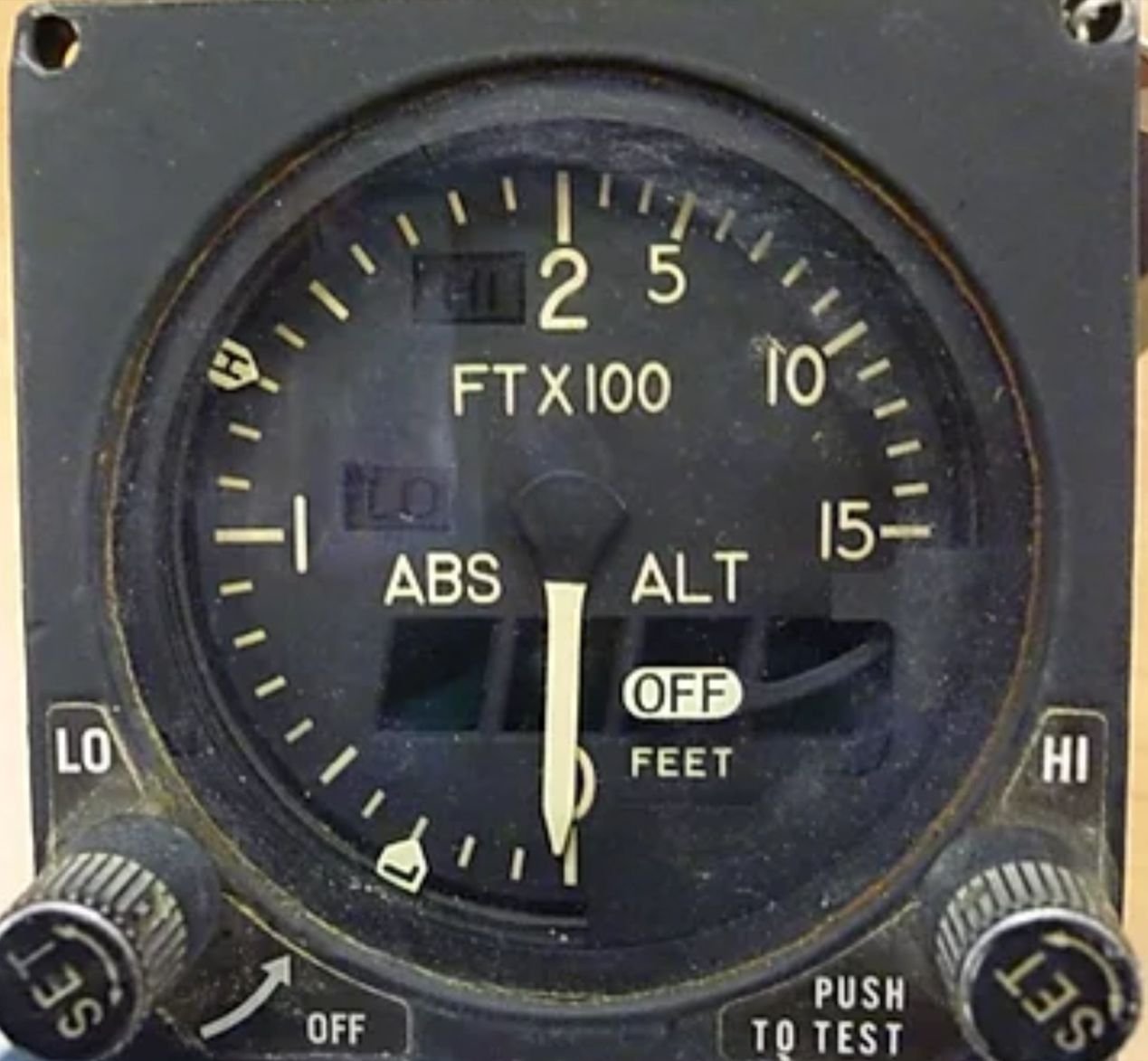
Last edited by Stagformation; 15th February 2025 at 23:01 .
Subjects
Altimeter (All)
HUD
Radar
Links are to this post in the relevant subject page so that this post can be seen in context.
Reply to this quoting this original post. You need to be logged in. Not available on closed threads.
February 16, 2025, 13:02:00 GMT
permalink Post: 11829223
ATC works very well. All efforts are made to avoid any confliction from the flight plan stage to the tactical stage - most of the time.
Pilots develop an awareness of other aircraft around them by listening to the RT, watching TCAS / Wx radar and looking out. This is most useful in understanding complicated situations - most of the time.
Even when the odd situation occurs where time and ideas run out and things are tight, people get away with it - most of the time.
But - not all the time. The Tenerife crash for instance involved a double transmission. One aircraft in extremis stuck on the foggy runway, trying desperately to stop the other rolling, while a tower communication took place and the RT was jammed. The question is, do we want to plan for these rare last second occurrences? I would guess yes - same philosophy as with GPWS and TCAS. We should have a means of communicating where an priority transmission overrides other radio traffic. There will be many who can explain why this can't be done, impossible, too expensive or unworkable. I am not here to explain in this modern and digital World how it should be done but you young bloods should suss out fairly quickly how it could be done. (spoiler - don't forget the open guard box)
Subjects
ATC
Radar
TCAS (All)
Links are to this post in the relevant subject page so that this post can be seen in context.
Reply to this quoting this original post. You need to be logged in. Not available on closed threads.
February 17, 2025, 03:42:00 GMT
permalink Post: 11829612
While the PAT 25 pilots, prior to take off, would set the barometric pressure each gauge must have no more than a +/- 75 foot error (FAA). One gauge may have read + 50 feet high while the other one read - 50 feet low which would account for the 100 foot difference in flight between the two barometric altimeters. Many mechanical and pilot input errors would be potential factors. Not common but sometimes a pilot will read back the correct setting while at the same time setting a different value by mistake. IF the 100 foot discrepancy was discussed initially on the ground it may account for the lack of discussion , later in the flight, while at 400 feet PM and 300 feet PF. It begs the question was radar altimeter planned to be used and if so when?
Even though there are some transmissions stepped on for various reasons, the words runway thirty three were mentioned a number of times. As crossing the threshold to runway 33 posed a significant risk to PAT 25 I would have thought the PAT 25 crew, to know from experience, that in 3 to 4 minutes from the time ATC reported the CRJ crossing the bridge the CRJ would pass directly in front of them at or near the same altitude. It's not clear to me why PAT 25 would not have reduced airspeed and or held at HAINS point.
I belive the simultaneous helicopter and runway 33 operations should never have been permitted. Clearance limits and expected further clearance times mirroring the ETA for rwy 33 given to helicopters to arrive at or hold at HAINS point would have be helpful in preventing conflicts.
Subjects
ATC
Altimeter (All)
CRJ
FAA
Night Vision Goggles (NVG)
Radar
Links are to this post in the relevant subject page so that this post can be seen in context.
Reply to this quoting this original post. You need to be logged in. Not available on closed threads.
February 17, 2025, 20:56:00 GMT
permalink Post: 11830154
For a landing aircraft on Rwy33, and assuming:
(1) correct QNH dialed in
(2) perfect centerline following
(3) perfect 3deg PAPI following
baro altitude would be 278 ft exactly above the east bank. And 200 baro altitude would come appr. 1.175 ft from the east bank and over the water.
Very hard to believe that aircrafts were routinely allowed to cross simultaneously this crossing. Statistically, the accident would have happened long ago, or at, the least, have reports filed (even from passengers) and brown underwear.
And btw, even top VIP seems that are considered much more expendable than we originally thought.
Think of it like a road with a traffic light (ATC) but you can merge on red if you can see it\x92s clear (helicopter). No rotary pilot I know would knowingly pass that close under/behind a jet transport as the wake could literally be the end of you at 200\x92AGL.
Subjects
ATC
QNH
Radar
Separation (ALL)
Links are to this post in the relevant subject page so that this post can be seen in context.
Reply to this quoting this original post. You need to be logged in. Not available on closed threads.
February 18, 2025, 12:39:00 GMT
permalink Post: 11830705
I've asked a question over on Rotorheads to see if anyone knows the actual clearance and service given to helicopters entering the DCA Class Bravo on the 'routes', and I'm happy to repeat it here. In London it's Radar Control ie. separation provided by ATC supported by radar. That's one part of the picture. The other is this startling revelation from Jennifer Homendy that there are no lateral limits to the 'routes', so in one sense they are not really 'routes' at all just guidelines with defined altitude limits. I can't find even altitude limits on the NY and Boston charts.
In other words, the way the 'routes' are used is quite possibly defined locally by custom and practice rather than designed with safety baked in by the authority, and that may be the way the authority intended things to be. In the UK every towered field has its own safety management system, as does the CAA. If these exist here at DCA and the FAA it would be instructive to have those examined as part of the investigation, because either they are not being used, or they're being ignored. Nobody could maintain that the risks on this 'route' were As Low As Reasonably Practicable (ALARP).
Last edited by Wide Mouth Frog; 18th February 2025 at 13:16 .
Subjects
ATC
DCA
FAA
NTSB Chair Jennifer Homendy
Radar
Separation (ALL)
Links are to this post in the relevant subject page so that this post can be seen in context.
Reply to this quoting this original post. You need to be logged in. Not available on closed threads.
March 10, 2025, 20:46:00 GMT
permalink Post: 11844860
For Low Observable: no, it's called "an overreaction"
- Military organizations and government organizations have a long history of doing stuff like that.
However, if you look at facts on the ground: Helos using Route 5 routinely followed I-395 and hooked around the east side of the Pentagon, which is closer to the RW15 piano keys than Route 4 is to RW33. Moreover, that stretch of roadway is elevated and has high-level lights, so the space under 200ft relative to river or runway level is that much tighter.
I also wonder how Route 5 traffic got tracked on DCA radar given high buildings and the Arlington ridge. .
Last edited by LowObservable; 10th March 2025 at 22:14 .
Subjects
DCA
Radar
Route 4
Route 5
Links are to this post in the relevant subject page so that this post can be seen in context.
Reply to this quoting this original post. You need to be logged in. Not available on closed threads.
March 21, 2025, 11:20:00 GMT
permalink Post: 11851281
 I always read you input as, while the detailed legal nitty-gritty is generally way beyond me, you always provide a refreshing viewpoint which is good to read! The aim of my Post, based on my interpretation of the above quote, was just to emphasise the existence of ASIAS is just as a tool or, rather, a set of tools but which has no real "proactive function" in itself. Yes, it represents a very small part of the Flight Safety chain - but as a resource in the main. As you say, there were loads of examples of what happened at DCA and my post was an explanation as to who, I believe, should have been looking at it. Maybe they did - and just ignored it? No idea!
In the UK, the airport operator is totally responsible for the safety of operations on or above their field out to 4000 ft on approach and departure - about 12 miles. The CAA who regulates aviation here, along with the Dept of Transport, but in conjunction with other stakeholders such as NATS (our en-route ATC organsiation), airlines and airfield operators etc, designs the airspace and sets the generic rules for it's use. As you said, the main rule is "Don't crash anything into anything else!". However, at the airfield, it is the airport operator who needs to ensure that the generic rules work in their environment. If a particular rule is legal but, if applied in their location, is unsafe, they can't apply that rule! That's what the Safety Case should say.
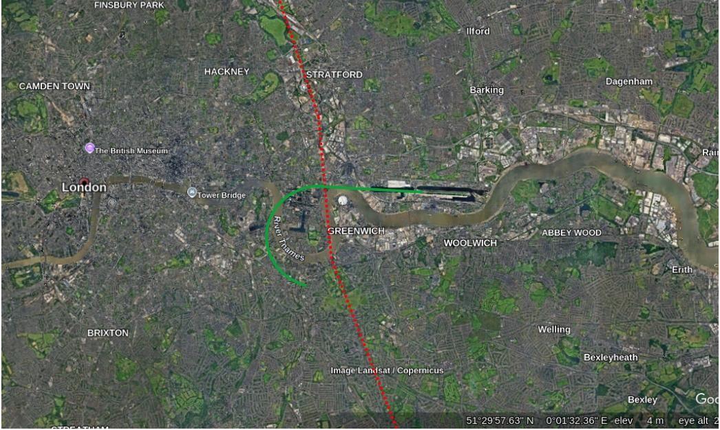
A relevant example? I used to regularly (for work) transit London S > N and N > S along the red dotted line below - at 2400ft as it kept me just out of the London TMA but as high as possible so, if it had all gone quiet on the engine front, I'd have the best chance to get the plane onto the ground with me alive and no-one else hurt. As part of the transit, I had to cross the final approach into London City (green line). So, say heading N, I'd chat to Thames Radar while over South London and would ask for a London City crossing. They'd chat to City ATC to co-ordinate and take me to the Thames before handing me to City Tower. My route over the Approach has aircraft at 1200 ft descending on the ILS and so I would have crossed anything landing at 1200 ft above that. So, while on first glance, it was fine I never, ever got that clearance with an aircraft landing - and for very good reasons. If the aircraft on the ILS had had to do a go-around, life could have become interesting very quickly. I was always held until the landing aircraft was well clear (ie ATC could see it was almost at the airfield) before they cleared me across. Indeed, legally, they could have given me a "You see the landing? Pass behind that"! But, no - always positive clearances. Got my vote ....... + gave me chance to enjoy the views of Greenwich and the City of London and "delayed" me a couple of minutes. OK, a bit unfair as LCY is "sleepy hollow" compared to DCA but, despite that, they were very friendly ..... but very strict!!!!!
So, when you are discussing (I think!!!) whether ATC elected to give PAT25 a "You visual? Pass behind" or whether it was "ordered" from on-high as it was deemed safe to do, ultimately, it is the ATCOs call on the day. Now, before I get flamed, do I blame the ATCO ? No! Well, why not? After all, he gave PAT permission! And yes, it was a "legal" clearance. But was it a wise clearance? When unpacking that little lot you have to look at a raft of Human Factors which influenced that ATCO on that night. He was on his own so, probably, the only way he could cope with all he had on his plate was to try and shift some responsibility onto PAT25 - one less thing for him to juggle. But even then, he needed to be monitoring which he clearly was - but while very busy with other approaches and departures so he just picked up a concern too late as the audio shows - "Are you sure you see the jet?". Another factor - was the strategy to use Route 4 while 33 was active something ATCers at DCA, over time, started in an effort to cut down radio traffic and speed things up? If so, had it been assessed and then monitored for adverse safety? While anecdotally, it seemed people were aware of "close calls", had any analysis taken place looking at the Databases? In the UK certainly, all the Airport Operator responsibility.
To the final "accountability" part re payments to families, the thing we have here is (and, folks, correct me if I've got this wrong) the FAA set the rules and the operate the Rules. Here, the CAA sets the rules and the Airfield Operator operates the rules. That is important - for eg, huge argument here in the UK about just how independent the UK's Military Flight Safety organisation is ..... as it is part of the Military. IMHO, what we have here are valid generic rules, some of which were simply not suitable in this specific location - just like crossing London City with an aircraft on approach - legal ...... but very unwise. As to who carries the can, well, as you said WR 6-3 , the legal beagles will get to the bottom of that ..... but it will take some time. I'll leave that side to you!!! My main question out of all of this is, why were not these issues flagged up by airport management for further investigation given it was something of an open "secret"? And where else (around the world) is this happening?

And, on that cheerful note...........! H 'n' H
Subjects
ATC
ATCO
Accountability/Liability
Close Calls
DCA
FAA
PAT25
Pass Behind
Pass Behind (All)
Radar
Route 4
Links are to this post in the relevant subject page so that this post can be seen in context.
Reply to this quoting this original post. You need to be logged in. Not available on closed threads.
March 22, 2025, 05:51:00 GMT
permalink Post: 11851870
The local controller had an Assistant ATC and a Supervisor to coordinate, monitor and regulate the traffic.
Class B airspace "ATC Clearances and Separation. An ATC clearance is required to enter and operate within Class B airspace. VFR pilots are provided sequencing and separation from other aircraft while operating within Class B airspace." source FAA Class B
One way to determine how the application of sequencing and separation to VFR pilots in this airspace was being applied would be to listen to the audio and watch radar replays over the weeks and months prior.
Subjects
ATC
Close Calls
DCA
FAA
PAT25
Radar
Route 4
Separation (ALL)
VFR
Links are to this post in the relevant subject page so that this post can be seen in context.
Reply to this quoting this original post. You need to be logged in. Not available on closed threads.
March 22, 2025, 11:33:00 GMT
permalink Post: 11851982
Now, one could say, "Well, there was a fairly steady flow of (maybe) 10 aircraft landing/taking off. So, 1 extra helicopter is not much more to add in!". True ...... but ...... an example. A mainline train arrives at a major London Station and, at once, all the doors open and several 1000 people all get off together and start heading up the stairs to the ticket barriers. The flow of traffic is heavy but quite ordered as the flow is all in one direction and so, while traffic density up the stairs maybe slows it down a bit, the flow is nicely ordered. Picture now, H 'n' H , being in a rush and so being one of the first off the train arriving at the ticket barrier only to realise - Durrrr - he's left his case back on the train. Being not-too-bright, I decide the quickest way to go back is down the same stairs I came up, and hence back to the train. Of course there's only 1 of me going down and several 1000 coming up. But to an onlooker gazing down, the effect of my single trip back against the several 1000 heading up has had a significant effect. TBH, H 'n' H is causing a fair degree of chaos as he pushes past everyone fighting his way back down the stairs against the flow. A few choice comments are being made by his fellow pax! What we have is a disproportionate effect caused by 1 vs 1000's.
So, while I'm no expert in how the brain works, usually the ATCO is dealing with a steady flow S - N and is sequencing things in their mind to smoothly land and depart traffic, slotting people in and out of the queue to achieve an orderly, safe, flow. All of a sudden, their "mental flow" now has something working in the other direction which all needs a bit more thought to ensure that everything remains safe. OK, 1 helo is not much, but it requires a disproportionate amount of extra "computing" compared to, say, adding another 1 aircraft into the main flow, to ensure safe separation. Was that why the "Own visual separation" offer was taken up? Now, rather than managing the contraflow, the ATCO only has to "monitor" the singleton swimming against the tide - which they were to a degree. Just a thought.
I'm not sure how long such tapes are kept? Usually it is a defined period after which the tape is recycled into the "system". Of course, looking further back, and in a perfect world, you could assess ATC SOPs against the buildup in traffic over the years and see how that's affected things over time. Was it the case of "a death by a 1000 cuts" which
WR 3-6
cited? Sadly, I suspect we'd need a crystal ball to study that. But retired Controllers could give a fairly good insight.
I mean the Airport Operator running the airfield. So, in the UK, that could be a company who then employ the Twr controllers to run that side just as they employ or contract Baggage Handlers, Cleaners, etc, etc. The UK ANSP (NATS) generally pick up everything above 4000 ft tho the actual hand-offs vary tactically and there can be local variations to suit specific airspace. So, for example, from memory, the Channel Islands work up to a higher level before en-route takes over. Below that, its up to the Airport Operator to staff their operation and make sure it's all safe and sound.
Anyway, better dash as already late........! Before yet more chaos is caused by H 'n' H !!!!!!

Subjects
ATC
ATCO
Radar
Separation (ALL)
VFR
Visual Separation
Links are to this post in the relevant subject page so that this post can be seen in context.
Reply to this quoting this original post. You need to be logged in. Not available on closed threads.
March 25, 2025, 16:48:00 GMT
permalink Post: 11854025
You are spot on in that there was no way for ATC or the helo crew to verify that the one the helo crew were watching (a/c B) actually wasn't the one that ATC thought they were watching (a/c A). That, as you say, was a very significant weakness. So they were on course to avoid the one they were watching. But that wasn't the one ATC had asked them to watch.
You are dead right in how difficult "see and avoid" is. I'm lucky as I only flew between small UK Regionals and, particularly when in my home patch, I often got from Twr "Visual with a/c A on Final? Join Final as #2 to a/c A!" type stuff. Worked OK when it was only me and a/c A. Any more and usually Approach sequenced me if I'd arrived SVFR by placing me under Radar Control for a short while before then handing me off to Twr to join the cct visually once faster traffic was well ahead of me. That's if they didn't forget me completely .... which happened once ...... but that's another story - they were most apologetic when I reminded them I was still on the last vector they'd given me!!!! "Sorry about that, I'd completely forgotten about you!"! Charming!
Subjects
ATC
Pass Behind
Pass Behind (All)
Radar
See and Avoid
Links are to this post in the relevant subject page so that this post can be seen in context.
Reply to this quoting this original post. You need to be logged in. Not available on closed threads.
March 26, 2025, 21:43:00 GMT
permalink Post: 11854783
Subjects
PAT25
Preliminary Report
Radar
Route 4
Separation (ALL)
Visual Separation
Links are to this post in the relevant subject page so that this post can be seen in context.
Reply to this quoting this original post. You need to be logged in. Not available on closed threads.
March 26, 2025, 22:07:00 GMT
permalink Post: 11854815
Subjects
ATC
CRJ
NTSB
Preliminary Report
Radar
Links are to this post in the relevant subject page so that this post can be seen in context.
Reply to this quoting this original post. You need to be logged in. Not available on closed threads.
March 27, 2025, 06:20:00 GMT
permalink Post: 11854966
Subjects
NTSB
Preliminary Report
Radar
Links are to this post in the relevant subject page so that this post can be seen in context.
Reply to this quoting this original post. You need to be logged in. Not available on closed threads.