January 30, 2025, 09:10:00 GMT
permalink Post: 11817027
Military Operations are 24/7/365 due to National Security issues.
https://www.loc.gov/resource/g3851p....,0.268,0.125,0
I have never flown there but if there's regular helicopter traffic 150ft below an ILS or circling approach airline crews familiar with the airport might tend to disregard TCAS proximate traffic, etc. as normal backdrop chatter.
Even when flying behind similar aircraft on an ILS in daylight and good visibility it takes quite some time to see that preceding traffic is slowing down as it only starts to "grow" at an alarming rate when quite close. I have witnessed that twice, once caused by self and another time caused by mismatched speed instructions from ATC. I have resolved to never accept visual separation to preceding traffic at night and while the European aversion to visual approaches might be excessive, high density night ops based on visual separation don't seem to be a good idea even without that crash.
Subjects
ATC
Altimeter (All)
Circle to Land (Deviate to RWY 33)
Radar
Route 4
Separation (ALL)
TCAS (All)
Visual Separation
Links are to this post in the relevant subject page so that this post can be seen in context.
Reply to this quoting this original post. You need to be logged in. Not available on closed threads.
January 30, 2025, 10:04:00 GMT
permalink Post: 11817076
MPN11, former Mil ATCO
Subjects
ATCO
Blackhawk (H-60)
DCA
PAT25
Radar
Route 4
Links are to this post in the relevant subject page so that this post can be seen in context.
Reply to this quoting this original post. You need to be logged in. Not available on closed threads.
January 30, 2025, 11:29:00 GMT
permalink Post: 11817139
The chart itself shows the <not above 200 MSL> symbol for the segment where the collision took place. That combined with the \x93via East bank\x85\x94 provides (some) procedural separation with traffic on final.. not much but some if the Route 4 traffic follows the east bank\x85 and stays below 200\x92\x85.
Subjects
CNN
Route 4
Separation (ALL)
Links are to this post in the relevant subject page so that this post can be seen in context.
Reply to this quoting this original post. You need to be logged in. Not available on closed threads.
January 30, 2025, 12:09:00 GMT
permalink Post: 11817176
vasaviation
Subjects
PAT25
Route 4
Links are to this post in the relevant subject page so that this post can be seen in context.
Reply to this quoting this original post. You need to be logged in. Not available on closed threads.
January 30, 2025, 12:30:00 GMT
permalink Post: 11817187
A 'human resource' failure rather than 'engineering' per se - though I fully agree with your comments otherwise. Remove the risk entirely - the best prevention, rather than try to minimise the probability of failure by adding more steps or 'aids'.
Low level helicopter Route 4 makes sense for the ease of helicopter positioning point of view and minimising noise etc impacts - following a river. But not right under an approacj path and especially not at night, using visual separation !
Subjects
Route 4
Separation (ALL)
Visual Separation
Links are to this post in the relevant subject page so that this post can be seen in context.
Reply to this quoting this original post. You need to be logged in. Not available on closed threads.
January 30, 2025, 13:08:00 GMT
permalink Post: 11817221
Yes, there is noise abatement and all that, but is there a compelling reason beyond that why the heli had to track the river in opposite direction to the flow of arriving airliners? Certainly, it would have been possible for a controller, radar-equipped or not, to hold the heli east of the field and clear him for a midfield crossing on heading 270 or so as an airliner is just touching down on 33 or 01 and the next one is still a few miles out? That would have kept him well out of the approach sector, allowed for a possible go-around of an arriving airliner and also would not interfere with departing traffic.
Surely, someone familiar with DCA can explain...
I would expect the airliner not to have to take any avoiding action, as it\x92d be IFR on a standard arrival for RW33. I would expect ATC to inform them of the helicopter traffic below them on the east side of the river.
I would expect the helicopter traffic to ultimately be responsible for avoidance, and they\x92d I guess be flying \x91Special VFR\x92*. But as they\x92re in controlled airspace then they should have been warned (which apparently they were) about the arriving civil traffic.
If the helicopter was, indeed, following Route 4 then what led to the discrepancy in position & height is conjecture. Also why they confirmed traffic in sight yet still collided is conjecture (& It\x92s possible they had their own emergency)
*) does \x91Special VFR\x92 exist/ apply for \x91night VMC\x92 ops in US controlled airspace ? it\x92s a long time since my FAA/US flying days\x85\x85
Subjects
ATC
DCA
IFR
Route 4
Traffic in Sight
Links are to this post in the relevant subject page so that this post can be seen in context.
Reply to this quoting this original post. You need to be logged in. Not available on closed threads.
January 30, 2025, 13:23:00 GMT
permalink Post: 11817231
I would expect the airliner not to have to take any avoiding action, as it\x92d be IFR on a standard arrival for RW33. I would expect ATC to inform them of the helicopter traffic below them on the east side of the river.
I would expect the helicopter traffic to ultimately be responsible for avoidance, and they\x92d I guess be flying \x91Special VFR\x92*. But as they\x92re in controlled airspace then they should have been warned (which apparently they were) about the arriving civil traffic.
If the helicopter was, indeed, following Route 4 then what led to the discrepancy in position & height is conjecture. Also why they confirmed traffic in sight yet still collided is conjecture (& It\x92s possible they had their own emergency)
*) does \x91Special VFR\x92 exist/ apply for \x91night VMC\x92 ops in US controlled airspace ? it\x92s a long time since my FAA/US flying days\x85\x85
Subjects
ATC
DCA
IFR
Route 4
Traffic in Sight
VFR
Links are to this post in the relevant subject page so that this post can be seen in context.
Reply to this quoting this original post. You need to be logged in. Not available on closed threads.
January 30, 2025, 13:43:00 GMT
permalink Post: 11817252
The chart itself shows the <not above 200 MSL> symbol for the segment where the collision took place. That combined with the \x93via East bank\x85\x94 provides (some) procedural separation with traffic on final.. not much but some if the Route 4 traffic follows the east bank\x85 and stays below 200\x92\x85.
Southbound, not above 200 feet to Goose Island, then not above 300 before the Wilson Bridge.
Screenshot elsewhere suggests the Blackhawk was initially at 200, then climbed early to 300, and then to 350\x85.
Subjects
Blackhawk (H-60)
Route 4
Separation (ALL)
Links are to this post in the relevant subject page so that this post can be seen in context.
Reply to this quoting this original post. You need to be logged in. Not available on closed threads.
January 30, 2025, 13:55:00 GMT
permalink Post: 11817263
Approach traffic seems to be approx 400-500ft at this point.
Which turnip decided it would be OK to allow vertical separation of 300ft on a busy approach path? And allow it VFR at night?
This accident was baked in. Bound to happen at some point.
Subjects
Route 4
Separation (ALL)
VFR
Vertical Separation
Links are to this post in the relevant subject page so that this post can be seen in context.
Reply to this quoting this original post. You need to be logged in. Not available on closed threads.
January 30, 2025, 14:10:00 GMT
permalink Post: 11817272
The golf course is on a peninsula in the river, so the helicopter was flying over water before and after it made the two turns.
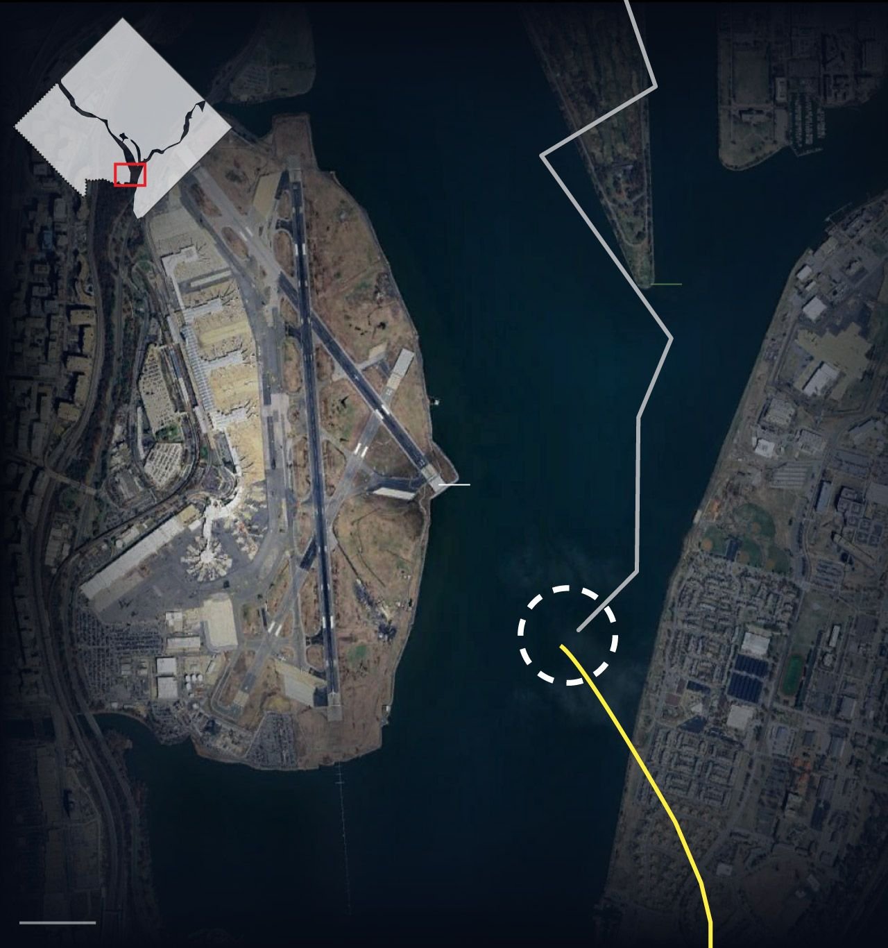
Subjects
ATC
DCA
Radar
Route 4
Links are to this post in the relevant subject page so that this post can be seen in context.
Reply to this quoting this original post. You need to be logged in. Not available on closed threads.
January 30, 2025, 14:32:00 GMT
permalink Post: 11817282
You could contact them if you want and tell them it\x92s wrong. No offense intended.
Even if it wasn\x92t a sharp turn, it was done over a golf course and their flight path was probably dictated by noise abatement reasons, as are those flown by jets flying into DCA.
Subjects
ATC
DCA
Radar
Route 4
Links are to this post in the relevant subject page so that this post can be seen in context.
Reply to this quoting this original post. You need to be logged in. Not available on closed threads.
January 30, 2025, 14:37:00 GMT
permalink Post: 11817285
my earlier point related to responsibility for separation\x85. and that the helo would be VFR (if following the low-level transit Route 4) and the airliner IFR. I was unsure if there was a special category for VFR at night\x85
apologies for sowing any confusion\x85\x85
Subjects
ATC
IFR
Route 4
VFR
Links are to this post in the relevant subject page so that this post can be seen in context.
Reply to this quoting this original post. You need to be logged in. Not available on closed threads.
January 30, 2025, 15:23:00 GMT
permalink Post: 11817324
Approach traffic seems to be approx 400-500ft at this point.
Which turnip decided it would be OK to allow vertical separation of 300ft on a busy approach path? And allow it VFR at night?
This accident was baked in. Bound to happen at some point.
In this case, the aircraft was flying an approach to one runway with a circle-to-land on RW-33. Ask any pilot; a circle to land in itself ups the work load. The margin for error of any kind at DCA is small and the 5200 foot runway isn't all that long. Even on a simple landing where none of these considerations are an issue, at some point the pilots reduce their "see and avoid" efforts and concentrate their efforts on achieving the proper line up and glide slope, rate of descent, aircraft configuration, flap setting, etc. etc. etc. In other words, the complicated routine required to safely land an airliner these days is already close to task overload even when things are going well. Add in the fact that it's night time at a very busy airport and looking out the window gets shoved pretty far down the "to do" list. But generally speaking, the system works because big busy airports pretty much operate using IFR rules and nearly all the aircraft are under close control. I other words, even on a crystal clear day under VFR flight conditions, someone is keeping a very close eye on the airliners coming and going from major airports. If a pilot makes a mistake and levels off at the wrong altitude, for example, there is a very good chance a controller will catch that error immediately even on a sunny VFR day. And that's a good thing because truth-be-told, when an airliner is seconds from touch down these days, there isn't much "see and avoid" going on. That's just the way it is.
But apparently DCA routinely has all sorts of helo traffic buzzing around under modified VFR flight rules. The pilots are talking to a controller but without being under the same sort of close control which is usually associated with how airliners operate. And they do that night and day, trusting the helo pilots to not make a mistake. But it looks like someone DID make a mistake last night and nobody caught it in time.
Subjects
ATC
Circle to Land (Deviate to RWY 33)
DCA
FAA
IFR
Route 4
See and Avoid
Separation (ALL)
VFR
Vertical Separation
Links are to this post in the relevant subject page so that this post can be seen in context.
Reply to this quoting this original post. You need to be logged in. Not available on closed threads.
January 30, 2025, 16:03:00 GMT
permalink Post: 11817358
As the approach to R33 crosses IDTEK (over the East bank of the river) at about 490 feet MSL, there is no way another aircraft can safely pass underneath at 200 feet MSL.
Thus, I think, the helicopter route RT 4 must be closed whenever an approach (visual or RNAV) to R33 is underway.
Subjects
Route 4
Separation (ALL)
Links are to this post in the relevant subject page so that this post can be seen in context.
Reply to this quoting this original post. You need to be logged in. Not available on closed threads.
January 30, 2025, 18:16:00 GMT
permalink Post: 11817497
To answer an earlier question , Yes they have CISM , NATCA is good at this , they will take care of the controllers.
@ fdr : our posts crossed each other , fully agree with you .
Subjects
Accident Waiting to Happen
CRJ
IFR
Route 4
Separation (ALL)
Vertical Separation
Links are to this post in the relevant subject page so that this post can be seen in context.
Reply to this quoting this original post. You need to be logged in. Not available on closed threads.
January 30, 2025, 19:33:00 GMT
permalink Post: 11817579
The people who design the charts and procedures have days and weeks to think things through, in a nice safe office, on the ground, going 0kts with good lighting.
Unless I'm missing something, it would seem that route 4 design is the main culprit here.
Subjects
ATC
Route 4
Links are to this post in the relevant subject page so that this post can be seen in context.
Reply to this quoting this original post. You need to be logged in. Not available on closed threads.
January 30, 2025, 20:08:00 GMT
permalink Post: 11817608
The people who design the charts and procedures have days and weeks to think things through, in a nice safe office, on the ground, going 0kts with good lighting.
Unless I'm missing something, it would seem that route 4 design is the main culprit here .
Subjects
ATC
Probable Cause
Route 4
Links are to this post in the relevant subject page so that this post can be seen in context.
Reply to this quoting this original post. You need to be logged in. Not available on closed threads.
January 30, 2025, 20:09:00 GMT
permalink Post: 11817611
Of Murphy’s Law, for those wondering
SPlot
Subjects
Route 4
Links are to this post in the relevant subject page so that this post can be seen in context.
Reply to this quoting this original post. You need to be logged in. Not available on closed threads.
January 30, 2025, 23:24:00 GMT
permalink Post: 11817756
The airliner is under IFR rules on its flight plan until it gets changed to a different runway, when it's then VFR.
The chopper is under VFR, stooging along a river at 200 ft and avoiding traffic on approach to Reagan by visual clues alone.
Radar useless as the aircraft are too low.
Airliner TCAS useless as inhibited, even if it can decode the military transponder's data.
Radio situational awareness compromised as chopper on UHF, airliner on VHF. So each aircraft can neither hear the other nor the ATC instructions to that aircraft.
It's difficult to see aircraft at night against a backdrop of a city with thousands of lights. And when you're gonna hit something, as others have said, that light doesn't move relative to you, so you don't notice it - it just blends into the background lights.
It only takes the chopper to misidentify the aircraft it's supposed to go behind and to therefore turn into the path of the airliner it was supposed to avoid - draw the map with the vectors and it all makes sense. These two aircraft ended up in the Potomac, but they could have ended up in much worse places in terms of loss of life on the ground.
Seems to me it's been an accident waiting to happen for some time.
"Radar useless as the aircraft are too low." - It seems there's valid radar returns from both aircraft. the FAA has a good diagram of the Potomac TRACON radar sites, about 10 different radars, and having visited the TRACON several times, they readily explain there's another nearly facility that is a duplicate of their radar feed, but for national security. I assume there's coverage till the river service for security to prevent someone from sneaking up the river with bad ideas
"Radio situational awareness compromised as chopper on UHF, airliner on VHF. " - I fly in the area and in my experience everyone is on the same VHF, they might be also duped to UHF and can hear everybody on my handheld. You hear AF-1 all the time on freq.
"The chopper is under VFR, stooging along a river at 200 ft and avoiding traffic" - Most of the area NE of the airfield in a prohibited area, and there's a lot of military installations within 5 miles of DC that they are shuttling around, so that path seems perfectly acceptable given the numerous constraints. there's nothing wrong with a helo corridor as long as you stay within it and maintain the prescribed altitude. Also, it's not like KDCA is some secret place, the flight paths are pretty well known if that's where you work. It's popular to sit in parks on both ends and watch the planes, there's literally millions of local people that know exactly the planes are coming and going on both directions. so if you're a helo there, you know where the hot spots are. Likewise, its not just any helo in that area, everyone is vetted, fingerprinted in the inner FRZ.
" on approach to Reagan by visual clues alone" - The UH-60 was not going to DCA, the assumption was it was using the helo route 4 corridor. All the UH-60Ls I've seen have full glass with moving map and I'm assuming a magenta line for the helo corridor.
Fun Fact - Calling it "Reagan" will get you tarred and feathered in the area. Folks refuse to utter the name and for years (decades) the Metro refused to rename the station until legally forced.
Last edited by Senior Pilot; 31st January 2025 at 00:05 . Reason: Prescribed/proscribed
Subjects
ATC
Accident Waiting to Happen
DCA
FAA
Hot Spots
IFR
KDCA
Pass Behind
Pass Behind (All)
Radar
Route 4
Situational Awareness
TCAS (All)
VFR
Links are to this post in the relevant subject page so that this post can be seen in context.
Reply to this quoting this original post. You need to be logged in. Not available on closed threads.
January 31, 2025, 02:15:00 GMT
permalink Post: 11817851
Who cares if it is a municipal golf course or not, because nobody is going to play golf at around 8:40 PM in the dark of night.
My point was that helicopters might fly over it because nobody would care about the noise, and people in residential neighborhoods do, whether the residential neighborhoods are officially listed as a noise abatement areas or not.
https://www.flyreagan.com/about-airp...raft-noise-faq
And it's pretty clear there's no turn at all in the first place, and that since there's no ads-b, this data point is an interpolation error. there's several other PAT ATC tracks from a the last few weeks doing the same training loop and the are all keeping in the rt4 and keeping 300ft msl
Subjects
ATC
PAT25
Route 4
Links are to this post in the relevant subject page so that this post can be seen in context.
Reply to this quoting this original post. You need to be logged in. Not available on closed threads.