January 31, 2025, 13:32:00 GMT
permalink Post: 11818203
When overflying the eastern side of the Potomac, the planes aligned with RW33 are between 220 and 270 ft MSL
Basically, route RT4 is designed to place the helicopters at the same height as planes approaching to land on RW33.
I believe that this corridor altitude was rather planned to avoid conflicts with RW01 approaches.
And, in my view, this corridor is incompatible with approaches to RW33.
By the way, the situation with approach to RW19 is marginally better: approaching planes are overflying the helicopter corridor RT1 up to the Franklin Roosevelt memorial where their paths diverge and, at that point, the planes are supposed to be at 420 ft and the helicopters at or below 200 ft.
The CNN article mentions several near-misses that happened with approaches to RW19.
So even if the helicopter stays in its route 4, bellow 200 ft MSL, they just can't fly directly bellow the approaching aircraft.
Subjects
CNN
Route 4
Separation (ALL)
Links are to this post in the relevant subject page so that this post can be seen in context.
Reply to this quoting this original post. You need to be logged in. Not available on closed threads.
January 31, 2025, 17:22:00 GMT
permalink Post: 11818389
A minimal response might be to review staffing policies in the tower; if radar equipped it would help to have someone solely responsible for the heli lane situationally aware of inbound traffic to the airport. If more change is acceptable then the heli routes should be examined and probably redesigned and traffic levels at Reagan at least examined.
I can see no reason to close the airport. Yes it is constrained and has short runways but many airports are similar. around the world. London City here is examining whether it can accept Airbus 320 neo aircraft with a 4965 foot runway and steep approaches in a very built up area.
There are wider issues - why do so many controllers sound like disk jockeys in the US whereas here they do their very best to sound calm.
I do believe some changes will come - just as line up and wait was introduced I believe the current clear to land will be replaced by continue approach and then clear to land only where it means that - the runway is clear and I know of no conflict to affect your landing. With this, some clearances still need to be conditional - At KDCA clearance to and 33 might be conditional on 01 traffic. Bit overall it is just clearer - and can be accommodated by most tower controllers given what thy have to deal with AFAICS.
Finally the suitability of see and avoid to night time operations will have to be examined.
Another iootionto make it safe was suggested elsewhere. Have an either/or arrangement.
If an airliner is on approach to runway 33, Heli Route 4 is closed.
If a helicopter has had approval to fly along Route 4, the approach to Runway 33 is not available.
Simple and straightforward?
Last edited by Pilot DAR; 31st January 2025 at 17:24 . Reason: fixed typo
Subjects
KDCA
Radar
Route 4
See and Avoid
Links are to this post in the relevant subject page so that this post can be seen in context.
Reply to this quoting this original post. You need to be logged in. Not available on closed threads.
February 01, 2025, 03:57:00 GMT
permalink Post: 11818752
Would suspending all operations of the cross runways not simplify the flow control and traffic management, while achieving the needs of the DOD and the unique needs of DC, without setting up new risks over densely populated areas? The primary runway is fit for purpose, the cross runways do not meaningfully increase operational capacity any more than a well set up series of taxiways at either end of the main runway.
The FAA's response is laudable as an immediate response, but it may not be the best risk mitigation in this case.
Subjects
CNN
FAA
Route 4
Links are to this post in the relevant subject page so that this post can be seen in context.
Reply to this quoting this original post. You need to be logged in. Not available on closed threads.
February 01, 2025, 23:39:00 GMT
permalink Post: 11819382
Having coffee this morning with my friend (my old CFI) who's a FO for one of the other American Eagle providers based at DCA, his opinion was that since that 5,200 ft on RWY33 is sufficient for an RJ, the primary reason he gets sidestepped to 33 about half the time is that it ends very close to the American's regional jet terminal and that using RWY33 saves wasting a couple hundred bucks to taxi for no reason which adds up with their large amount of activity. I don't fly there but as pax I on an RJ, with those winds in VFR, in my experience we landed 33 maybe 40% of the time.
My friend doesn't speak for all the RJ pilots obviously, but he didn't consider this sidestep to 31 to be at all unexpected or in his mind adding any significant risk and mentioned it was part of his localization checkout (his company has specific ground and line training required for the airfield). Most tellingly, he literally said it was not on his Top Ten gripes about DCA (he likes to complain a bit 😀

The problem with systemic failures is the come along looking like excellent alternatives until the wheels fall off the wagon and it ends in tears. You have to be lucky 100% of the time, the grim reaper only needs one win.
Subjects
ATC
Circle to Land (Deviate to RWY 33)
DCA
Route 4
VFR
Links are to this post in the relevant subject page so that this post can be seen in context.
Reply to this quoting this original post. You need to be logged in. Not available on closed threads.
February 02, 2025, 15:04:00 GMT
permalink Post: 11819846
But from the beginning, various plots have shown the collision occurring in mid-river. A little work with Google Earth will show that the extended 33 centre line reaches mid-river about 3,300 feet from the aimpoint of runway 33. A 3 degree glideslope and some trig will put it at 175 feet at that range, with obvious implications. 375 feet would be a big error with not much more than half a mile left to run.
What am I doing wrong?
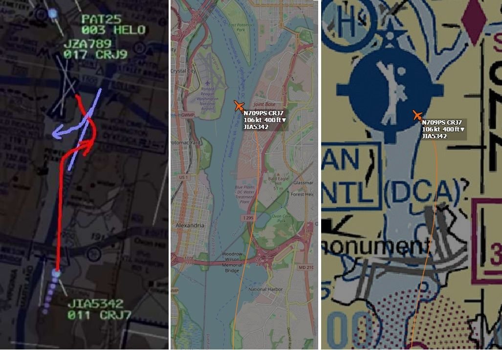
Also, helicopter route 4 hugs the eastern bank of the Potomac until Goose Island and doesn't cross to the western bank until Wilson Bridge. So why did the Black Hawk perform a 45 degree right turn while still abeam DCA? (See, e.g., post #25) Was it intending to route direct to Fort Belvoir, ignoring the heli routes? (I think I've seen it was operating out of Joint Base Anacostia en route to Fort Belvoir, so the fact it was still abeam DCA must have been more than obvious.)
Puzzled.
Last edited by DespairingTraveller; 2nd February 2025 at 15:24 . Reason: edited to correct typo
Subjects
Blackhawk (H-60)
CRJ
DCA
NTSB
Route 4
Links are to this post in the relevant subject page so that this post can be seen in context.
Reply to this quoting this original post. You need to be logged in. Not available on closed threads.
February 02, 2025, 16:35:00 GMT
permalink Post: 11819905
But from the beginning, various plots have shown the collision occurring in mid-river. A little work with Google Earth will show that the extended 33 centre line reaches mid-river about 3,300 feet from the aimpoint of runway 33. A 3 degree glideslope and some trig will put it at 175 feet at that range, with obvious implications. 375 feet would be a big error with not much more than half a mile left to run.
What am I doing wrong?
Also, helicopter route 4 hugs the eastern bank of the Potomac until Goose Island and doesn't cross to the western bank until Wilson Bridge. So why did the Black Hawk perform a 45 degree right turn while still abeam DCA? (See, e.g., post #25) Was it intending to route direct to Fort Belvoir, ignoring the heli routes? (I think I've seen it was operating out of Joint Base Anacostia en route to Fort Belvoir, so the fact it was still abeam DCA must have been more than obvious.)
Puzzled.
Assuming the NTSB figure of 375ft is correct, you still need more info for it to mean anything. Was that the AGL, AMSL or SPS height/altitude?
How accurate are the 'various plots' that indicate the collision occurred mid-river? They may be right; they may not be.
Was the CRJ on final or was it still positioning to final? If it wasn't on final then the trigonometric calculations of what height it should be at might not be correct.
What official evidence is there that the Blackhawk made a 45 degree turn, or could that be a data error in the publicly available information?
In summary what I am saying is that, despite all of the internet sleuths plotting tracking data, none of it is official and it is all subject to various errors. Whilst interesting to form an understanding of the circumstances, it can't be assumed to be accurate to within a few feet (vertically or laterally).
All UH-60 A and L Army aircraft incorporated the APN 209 radar altimeter. Our Sikorsky tech fellow for Avioics/electronis reports the accuracy in this area is 1-2 feet. The radar altimeter position in the instrument panel is just to the right of the attitude indicator and its top matches the top of the attitude indicator. The barometric altimeter is immediately below it.
Both pilots have the same setup.
Subjects
ATC
Altimeter (All)
Barometric Altimeter
Blackhawk (H-60)
CRJ
DCA
NTSB
Radar
Radio Altimeter
Route 4
TCAS (All)
Links are to this post in the relevant subject page so that this post can be seen in context.
Reply to this quoting this original post. You need to be logged in. Not available on closed threads.
February 02, 2025, 23:05:00 GMT
permalink Post: 11820185
1. In an effort to maximize commercial air traffic in and out of DCA, the FAA has created the “deviate to RWY 33 procedure” for air traffic in-bound to RWY 01. This requires a right-hand turn from the RWY 01 approach followed by an immediate hard left-hand turn to line up on RWY 33. FAA criteria for a stabilized approach states that you have to be stable at 500 feet AGL on final in VMC or perform an immediate go-around. But on this particular approach, you will be at or below 400 feet AGL as you come out of the left turn to final. So the FAA has granted an exception to the “stabilized requirements” at DCA to allow for this maneuver. This allows ATC to shorten the distance between arriving and departing aircraft that are utilizing conflicting RWYs. The FAA in essence violates its own safety standards on stabilized approaches for the sake of expediency.
2. The FAA creates the Route 1/4 helicopter route through the DCA airspace as a VFR route with constantly changing altitude requirements. The lowest limit is at 200 ft MSL through the area east of DCA. Any pilot will tell you that flying that low over water at night is a best a tense experience. Try not to break that limit flying at night while also trying to communicate with ATC and simultaneously searching for possible conflicting aircraft.
3. The United States Army Aviation Branch deems it acceptable to allow training missions for Army Reserve pilots with limited flying experience to fly these helicopter routes through this complex and extremely active airspace. Compounding this, training flights at night using night-vision goggles are deemed “safe” in spite of the fact that using said goggles severely limits peripheral vision and makes it difficult if not impossible to perceive any color other than green and white. Picking out particular lights against the background of urban lighting is challenging, as is depth perception. Scanning key cockpit instruments is also made more difficult, making it challenging to accurately maintain altitude. Add to that workload the need to be in constant communication with ATC as well as monitoring all other comms traffic not directed to you but necessary in order to maintain good situational awareness. Given the density of commercial air traffic on this route, common sense would dictate that this route be flown by only the most experienced pilots and only when absolutely necessary. Reasonable logic would understand that conducting training missions should not be using final approach areas with heavy commercial traffic.
4. The Army crew on PAT25 are flying a mission they have been ordered to fly, at night and using night vision goggles. Although they may feel it is difficult and may be anxious about it, their command structure has determined that it is an appropriate training procedure and as such must meet minimum safety requirements. They do not have the authority to question the mission or the orders to fly it.
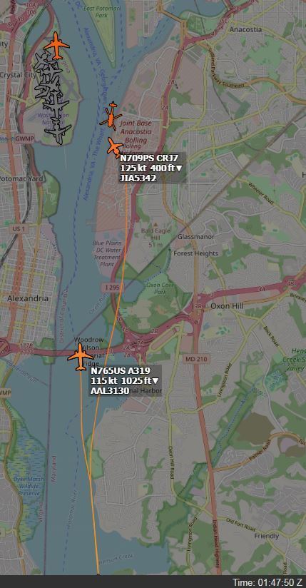
5. JIA342 is on approach for RWY 01, but is asked at the last minute by ATC to deviate to RWY 33, requiring the “circle to land” maneuver. Therefore, they are now on approach different from what they briefed for.
6. Any aircraft following the “circle to land” approach to RWY 33 will most likely have both pilots focused on RWY 33 as they come out of the left turn to final, especially if it was a last-minute request by ATC. In this case they will be looking to make sure that AA1630, which has just been given clearance to depart from RWY 01, is clear of the intersection with RWY 33 as they complete their final approach, and be ready for a go-around if it is not. In addition, this left bank makes it extremely difficult for the first officer to see any conflicting traffic coming towards them from the 1 to 2 o’clock position, as that traffic will probably be below the right window level. For the pilot, who is on the left side of the cockpit, visibility of such conflicting traffic will be nearly impossible.
7. For whatever reason, ATC is working with “split frequencies while controlling this airspace, so that although the controller hears both the aircraft on approach and the helo traffic south-bound on “Route 1”, the pilots of those respective aircraft only hear information directed at them. Thus they are not aware of all that is going on around them, and as such their situational awareness is limited by factors outside of their control.
8. ATC informs PAT25 of the conflicting aircraft on approach for RWY 33 at 1200 feet MSL, but at the time, PAT25 is heading almost due east towards the Jefferson Memorial on Helo Route 4 while JIA342 (the CRJ) is executing its right turn departing from the RWY 01 approach and is now heading in a northeast direction as it prepares to make a hard left onto the RWY 33 short final approach. From their respective positions, PAT25 in all likelihood sees the landing lights of AA3130 which is trailing JIA342 and whose landing lights are pointed almost directly in his direction, and mistakenly identifies it as the aircraft approaching RWY 33. At no time does it appear that ATC notifies JIA342 of the conflicting helo traffic. They are most likely focused on their approach to RWY 33, which was just handed to them.
9. As JIA342 rolls out of its left hand turn to final on RWY 33, completing the deviation they were just handed and had not briefed for, it is now approaching the 9-11 o’clock position of PAT25. Since the pilot of PAT25 is on the right-hand side of the Blackhawk, visibility of the CRJ may be limited. Both pilots of PAT25 are now most likely visibly fixated on passing to the rear of AA3130, which is in their 1-3 O’clock position, and which is the conflicting aircraft they perceive as the one ATC initially warned them about.
10. ATC, now receiving a conflicting aircraft warning, asks PAT25 if they have JIA342 in sight. In the absence of any obvious difference from the first mid-identification of the conflicting traffic, confirmation bias raises its ugly head. The voice response from the training pilot is calm and confident in stating that they do have it in sight and claim visual separation, probably proving once again that he mistakenly has AA3130 in sight slightly to his right directly in front of him and more than a mile away. Both pilots are totally unaware of JIA342 which is now arriving in front of them from their left.
11. The collision occurs.
In my humble opinion, the crews of both aircraft involved were set up by both the FAA and the Army Department of Aviation through a series of poorly based decisions which focused on expediency and departed from any appropriate utilization of a rational use of risk assessment. Consider the following:
1. Approval of the circling to RWY 33 maneuver which violates normal stabilized approach standards.
2. The establishment of a series of complex VFR helicopter track complex and heavily restricted air space as well as through final approach paths.
3. A 200 foot maximum altitude requirement over water and required even at night, which may result in a less than 200 foot vertical separation between aircraft on approach to RWY 33 and those traveling on Helo Route 1/4.
4. The decision to conduct military training missions in this complex and busy airspace with an abundance of commercial passenger traffic either arriving to or departing from DCA.
5. The use of split frequencies by the FAA which negatively impacts the situational awareness of all of the pilots in the airspace.
6. The use of night vision goggles to place even more limitations on the pilots.
Granted, all pilots involved may not have had the thousands of hours senior commercial and military pilot possess. But even the most senior individuals when placed in the task saturated environments these two crews faced would have at the very least felt their “pucker factor” increase through this. And there is probably an equal chance that the lack of common sense and appropriate safety design exhibited by the controlling entities would have resulted in a similar outcome. The odds were significantly stacked against these two flight crews, and unfortunately, against the passengers and flight attendants as well. If ever there were an example of an accident waiting to happen, this is it.
Subjects
ATC
Accident Waiting to Happen
Blackhawk (H-60)
CRJ
DCA
FAA
NTSB
PAT25
Route 4
Separation (ALL)
Situational Awareness
VFR
Vertical Separation
Visual Separation
Links are to this post in the relevant subject page so that this post can be seen in context.
Reply to this quoting this original post. You need to be logged in. Not available on closed threads.
February 03, 2025, 11:08:00 GMT
permalink Post: 11820420
9. As JIA342 rolls out of its left hand turn to final on RWY 33, completing the deviation they were just handed and had not briefed for, it is now approaching the 9-11 o\x92clock position of PAT25. Since the pilot of PAT25 is on the right-hand side of the Blackhawk, visibility of the CRJ may be limited. Both pilots of PAT25 are now most likely visibly fixated on passing to the rear of AA3130, which is in their 1-3 O\x92clock position, and which is the conflicting aircraft they perceive as the one ATC initially warned them about.
Subjects
ATC
Blackhawk (H-60)
CRJ
DCA
Night Vision Goggles (NVG)
PAT25
Route 4
Links are to this post in the relevant subject page so that this post can be seen in context.
Reply to this quoting this original post. You need to be logged in. Not available on closed threads.
February 03, 2025, 22:46:00 GMT
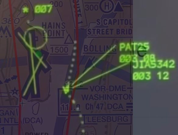
permalink Post: 11820975
No crossing of 'Route 4' prior to ...
Subjects
CRJ
Circle to Land (Deviate to RWY 33)
Pass Behind
Pass Behind (All)
Route 4
Links are to this post in the relevant subject page so that this post can be seen in context.
Reply to this quoting this original post. You need to be logged in. Not available on closed threads.
February 03, 2025, 23:43:00 GMT
permalink Post: 11821022
I agree that these are just guesses, but the alternative seems to be that the helo just drifted to the right randomly, for no specific reason, which seems unlikely.
Subjects
CRJ
Radar
Route 4
Separation (ALL)
Links are to this post in the relevant subject page so that this post can be seen in context.
Reply to this quoting this original post. You need to be logged in. Not available on closed threads.
February 04, 2025, 00:35:00 GMT
permalink Post: 11821049
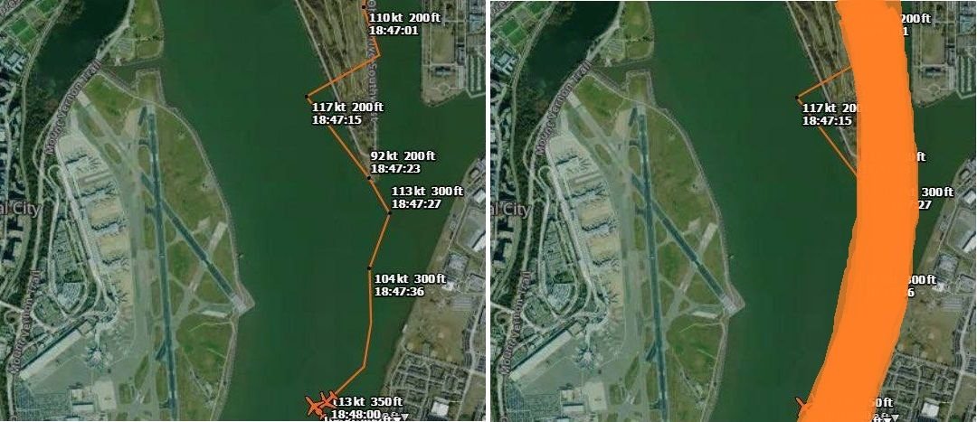
And the "amateur MLAT" tracking of the helo, is only a rough indication of the trajectory with a wide margin of position error and should be interpreted more like the right side hereunder:
Subjects
CRJ
KDCA
Radar
Route 4
Links are to this post in the relevant subject page so that this post can be seen in context.
Reply to this quoting this original post. You need to be logged in. Not available on closed threads.
February 04, 2025, 00:36:00 GMT
permalink Post: 11821050
https://www.youtube.com/shorts/bHBKptJWXtU
I agree that these are just guesses, but the alternative seems to be that the helo just drifted to the right randomly, for no specific reason, which seems unlikely.
Subjects
CRJ
Radar
Route 4
Separation (ALL)
Links are to this post in the relevant subject page so that this post can be seen in context.
Reply to this quoting this original post. You need to be logged in. Not available on closed threads.
February 04, 2025, 10:54:00 GMT
permalink Post: 11821297
Subjects
Route 4
Separation (ALL)
Situational Awareness
Links are to this post in the relevant subject page so that this post can be seen in context.
Reply to this quoting this original post. You need to be logged in. Not available on closed threads.
February 04, 2025, 13:28:00 GMT
permalink Post: 11821431
And the "amateur MLAT" tracking of the helo, is only a rough indication of the trajectory with a wide margin of position error and should be interpreted more like the right side hereunder:
Thanks for that insight as well.
It's almost as though wearing the NVG in the vicinity of the airport on that evening would, by itself, create a degraded lookout ability. Seems counterintuitive unless one gets into the details of how NVGs work.
Subjects
KDCA
Night Vision Goggles (NVG)
Route 4
Links are to this post in the relevant subject page so that this post can be seen in context.
Reply to this quoting this original post. You need to be logged in. Not available on closed threads.
February 05, 2025, 19:16:00 GMT
permalink Post: 11822469
The position of the collision shown in the radar data overlay is consistent with the position of the RJ as shown in ADS-B Exchange at the time of the collision (approximately 01:47:59Z according to the NTSB timeline). See this link from DIBO for the RJ Track with timing AA5342 Down DCA In my experience, times in ADS-B Exchange are generally accurate to within 2 seconds. Given all that, I believe that the Black Hawk was within the horizontal bounds of Route 4 at the time of the collision and that it did not make the right turn we see in the ADS-B Exchange map.
Edit: Corrected route number and helicopter
Last edited by airplanecrazy; 6th February 2025 at 01:24 .
Subjects
AA5342
ADSB (All)
Blackhawk (H-60)
DCA
NTSB
Radar
Route 4
Links are to this post in the relevant subject page so that this post can be seen in context.
Reply to this quoting this original post. You need to be logged in. Not available on closed threads.
February 05, 2025, 20:18:00 GMT
permalink Post: 11822515
The other thing that comes to mind is along the lines of: OK I’m coming up on the extended centerline and haven’t heard a call from the traffic, and haven’t seen it, and yet I proceed as if the traffic was either short final or landing, or way off to my left , so far away I can’t see it? The Hawk doesn’t query the tower re the position of the other traffic? Think I saw a reference to the Hawk having a FDR/CVR-had to have been an aftermarket install- and that voice record might be illuminating.
Last thought: over some years I’ve had the pleasure ( several times each location ) of flying the heliroutes at two other capitols: London and Paris. Both are a pleasure to fly and tightly controlled. As one might imagine the amount of traffic when the Farnborough or Paris Airshows are running is impressive, yet they know where all of their traffic is and the associated commo is handled so as to provide no doubt about other traffic as it affects your place in the operation. The story we are uncovering here is a shock.
Subjects
Route 4
Links are to this post in the relevant subject page so that this post can be seen in context.
Reply to this quoting this original post. You need to be logged in. Not available on closed threads.
February 05, 2025, 23:51:00 GMT
permalink Post: 11822641
Questions:
Why was PAT 25 search light in the stowed position and not motored to a more forward position?
Why are PAT helicopters not M models with FD's so PAT 25 could have been coupled on route 4 while at 200' giving the PF more time to look for traffic?
Was there pressure to use NVG along route 4 to meet the hourly requirements for currency?
Why did PAT 25 not slow down or hold at Hains in order to pass behind the CRJ as per their clearance?
Why was it ops normal after a near miss the previous day and then only one crew chief instead of two for PAT 25?
Why was the controller task saturated?
Why over the years, as the airport got busier, someone didn't suggest, for night operations, only one aircraft on route 4 or only one aircraft on the approach to 33 at a time and prohibit simultaneous operations?
IMO while the CRJ was turning final to rwy 33 PAT 25 may have experienced the CRJ landing lights in the cockpit and may have chosen up and right rather than left and down. Note worthy, PAT 25 RAD ALT gauge scale changes dramatically at 200'.
Maybe an upgrade to Dulles with a high speed train connection...
Subjects
ATC
CRJ
Close Calls
Night Vision Goggles (NVG)
Pass Behind
Pass Behind (All)
Route 4
Links are to this post in the relevant subject page so that this post can be seen in context.
Reply to this quoting this original post. You need to be logged in. Not available on closed threads.
February 06, 2025, 01:54:00 GMT
permalink Post: 11822687
Questions:
Why was PAT 25 search light in the stowed position and not motored to a more forward position?
Why are PAT helicopters not M models with FD's so PAT 25 could have been coupled on route 4 while at 200' giving the PF more time to look for traffic?
Was there pressure to use NVG along route 4 to meet the hourly requirements for currency?
Why did PAT 25 not slow down or hold at Hains in order to pass behind the CRJ as per their clearance?
Why was it ops normal after a near miss the previous day and then only one crew chief instead of two for PAT 25?
Why was the controller task saturated?
Why over the years, as the airport got busier, someone didn't suggest, for night operations, only one aircraft on route 4 or only one aircraft on the approach to 33 at a time and prohibit simultaneous operations?
IMO while the CRJ was turning final to rwy 33 PAT 25 may have experienced the CRJ landing lights in the cockpit and may have chosen up and right rather than left and down. Note worthy, PAT 25 RAD ALT gauge scale changes dramatically at 200'.
Maybe an upgrade to Dulles with a high speed train connection...
Not the latest model? Guess what, combat units get the latest models. These missions are transport, not combat roles. Budgets and priorities rule. There are VH-60s in the battalion, they\x92re probably not scheduled for check rides or training flights.
One RA does not rewrite the schedule, likely not even unusual in DCA. The previous crew may not have passed the event on. I\x92ve had numerous RAs, never a report. The NTSB has stopped asking for reports for events involving VFR traffic.
While nice to have, there\x92s no place for a second crew chief to have a forward view. And the CC may or may not be \x93in the loop\x94. They\x92re crew chiefs, not pilots. We had them on C-5 and they mostly slept in flight as they too much to do on the ground.
Subjects
ATC
CRJ
Close Calls
DCA
NTSB
Night Vision Goggles (NVG)
Pass Behind
Pass Behind (All)
Route 4
TCAS RA
VFR
Links are to this post in the relevant subject page so that this post can be seen in context.
Reply to this quoting this original post. You need to be logged in. Not available on closed threads.
February 07, 2025, 00:09:00 GMT
permalink Post: 11823328
Did the FAA or the Army assume they would always be able to apply visual (NOT VFR) separation. Visual separation does not necessarily mean 500\x92 vertically and 1.5 nm or radar target separation; it means \x93I see you, I miss you\x94. Did the operating plan always direct crews to use visual separation as the default plan? I hope not, but it is only I see it being written.
Subjects
FAA
IFR
Radar
Route 4
Separation (ALL)
VFR
Visual Separation
Links are to this post in the relevant subject page so that this post can be seen in context.
Reply to this quoting this original post. You need to be logged in. Not available on closed threads.
February 07, 2025, 14:59:00 GMT
permalink Post: 11823702
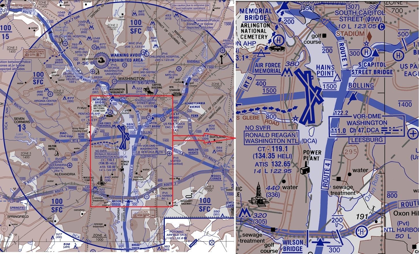
Anything approaching Rwy 1 should be below ~700ft anywhere north of the sewage treatment marker; use the Wilson Bridge for a bit of headroom because not all aircraft are going to be perfectly on glideslope.
The river is far narrower than 1.5Nm so clearly a southbound helicopter on Route 4 can never cross a northbound aircraft approaching runway 1 north of the Wilson Bridge.
You'd have to hold a southbound helicopter north of either the Memorial or Capitol St Bridges until previous traffic had landed. Then have a sufficiently large gap with no arrivals (or departures until south of the runways) for the helicopter to reach the Wilson St Bridge before the next arrival crosses that bridge.
That's the preceding aircraft covering ~3Nm at 140kt (~80s), followed by the helicopter covering ~6Nm at ~100kt (another 3.5min), and accurately timing the next arrival so it doesn't cross the Wilson bridge until after the helicopter, or it needs to do a go-around.
Subjects
Route 4
Route 5
Separation (ALL)
Links are to this post in the relevant subject page so that this post can be seen in context.
Reply to this quoting this original post. You need to be logged in. Not available on closed threads.