February 07, 2025, 15:57:00 GMT
permalink Post: 11823730
Subjects
ATC
Route 4
Links are to this post in the relevant subject page so that this post can be seen in context.
Reply to this quoting this original post. You need to be logged in. Not available on closed threads.
February 07, 2025, 15:59:00 GMT
permalink Post: 11823731
Anything approaching Rwy 1 should be below ~700ft anywhere north of the sewage treatment marker; use the Wilson Bridge for a bit of headroom because not all aircraft are going to be perfectly on glideslope.
The river is far narrower than 1.5Nm so clearly a southbound helicopter on Route 4 can never cross a northbound aircraft approaching runway 1 north of the Wilson Bridge.
You'd have to hold a southbound helicopter north of either the Memorial or Capitol St Bridges until previous traffic had landed. Then have a sufficiently large gap with no arrivals (or departures until south of the runways) for the helicopter to reach the Wilson St Bridge before the next arrival crosses that bridge.
That's the preceding aircraft covering ~3Nm at 140kt (~80s), followed by the helicopter covering ~6Nm at ~100kt (another 3.5min), and accurately timing the next arrival so it doesn't cross the Wilson bridge until after the helicopter, or it needs to do a go-around.
Hence the issue requiring metering the helicopters on the numbered Routes.
I don't suggest a hard 1.5NM, but anywhere standard fixed wing ops cannot assure 500' vertical separation, Rotary wing traffic must be gated and controlled.
If rotary wing mission dictates, then fixed wing traffic will have to wait/go missed/discontinue approach. Visual Sep, ATC and a Pavlovian environment killed an airliner.
Subjects
ATC
Route 4
Route 5
Separation (ALL)
Vertical Separation
Links are to this post in the relevant subject page so that this post can be seen in context.
Reply to this quoting this original post. You need to be logged in. Not available on closed threads.
February 07, 2025, 16:59:00 GMT
permalink Post: 11823780
* re the NVGs, I found an old video I shot of trying to drive with mine and coming around a corner to a bright street light at first the light bloomed across a good portion of the display and then the thing ramped down gain until the light was a pinpoint surrounded by black. Good thing I had it on one eye! I assume that if you have them on and look at a landing plane with lights on you get the same, either blooming or black with pinpoints.
Last edited by island_airphoto; 7th February 2025 at 17:16 .
Subjects
ATC
Night Vision Goggles (NVG)
Route 4
Links are to this post in the relevant subject page so that this post can be seen in context.
Reply to this quoting this original post. You need to be logged in. Not available on closed threads.
February 07, 2025, 17:07:00 GMT
permalink Post: 11823784
I don't suggest a hard 1.5NM, but anywhere standard fixed wing ops cannot assure 500' vertical separation, Rotary wing traffic must be gated and controlled.
If rotary wing mission dictates, then fixed wing traffic will have to wait/go missed/discontinue approach. Visual Sep, ATC and a Pavlovian environment killed an airliner.
I'm still going to argue that a helicopter on Route 4 from DCA to the Wilson Bridge or across Route 6 is unacceptable while there's an approaching aircraft below 700ft.
Subjects
ATC
DCA
Route 4
Separation (ALL)
Vertical Separation
Links are to this post in the relevant subject page so that this post can be seen in context.
Reply to this quoting this original post. You need to be logged in. Not available on closed threads.
February 07, 2025, 21:42:00 GMT
permalink Post: 11823950
Subjects
Route 4
Links are to this post in the relevant subject page so that this post can be seen in context.
Reply to this quoting this original post. You need to be logged in. Not available on closed threads.
February 07, 2025, 21:48:00 GMT
permalink Post: 11823958
Subjects
Route 4
Links are to this post in the relevant subject page so that this post can be seen in context.
Reply to this quoting this original post. You need to be logged in. Not available on closed threads.
February 11, 2025, 19:28:00 GMT
permalink Post: 11826281
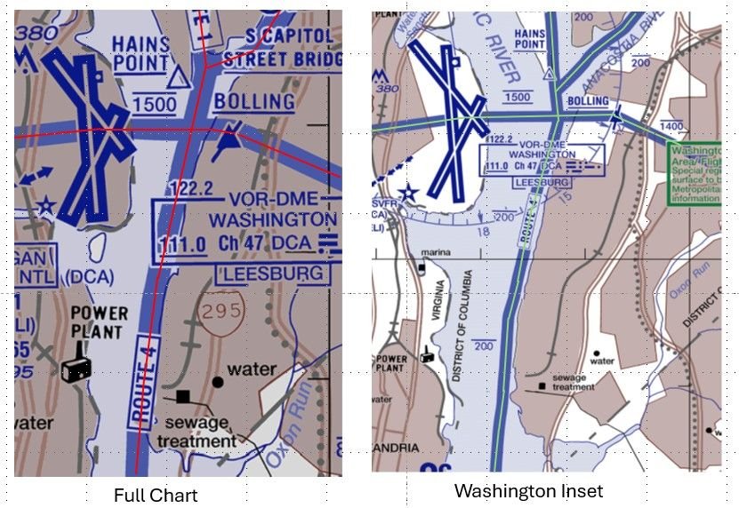
DCA Helicopter Routes
Given these chart differences, I wonder how far a helicopter can stray from the various depictions of a route before it is considered a pilot deviation? Perhaps the NTSB will give us some insight with their accident report.
Last edited by airplanecrazy; 14th February 2025 at 23:53 . Reason: Emphasize the route "appear"
Subjects
DCA
FAA
NTSB
PAT25
Route 4
Separation (ALL)
Visual Separation
Links are to this post in the relevant subject page so that this post can be seen in context.
Reply to this quoting this original post. You need to be logged in. Not available on closed threads.
February 14, 2025, 23:38:00 GMT
permalink Post: 11828295
I think that the "width" that you are referring is for the chart maker but not the actual width of a helicopter route.
I can't find in any FAA document a definition of the lateral extent of a helicopter route. Is there one?
Subjects
FAA
Route 4
Links are to this post in the relevant subject page so that this post can be seen in context.
Reply to this quoting this original post. You need to be logged in. Not available on closed threads.
February 15, 2025, 01:45:00 GMT
permalink Post: 11828334
"RT. 4: FORT WASHINGTON OVER POTOMAC RIVER TO WILSON BRIDGE. THEN VIA EAST BANK
OF POTOMAC RIVER TO ANACOSTIA RIVER. INTERCEPT ROUTE 1 AT ANACOSTIA RIVER.
ALTITUDES: AT OR BELOW 1000 FEET MSL AT FORT WASHINGTON, DESCEND TO 600 FEET
MSL ABEAM BROAD CREEK INLET, BEGIN DESCENT FROM 600 FEET MSL TO
ARRIVE AT 300 FEET MSL OVER WILSON BRIDGE, THEN AT OR BELOW 200 FEET MSL NORTH
OF WILSON BRIDGE.
It would seem to me that "OVER POTOMAC RIVER" and "VIA EAST BANK OF POTOMAC RIVER" would indicate some sort of "boundary."
I think that this Helicopter Route Chart is poorly done and would like to know how the FAA designates helicopter routes and who designs these charts.
In my opinion the New York Special Flight Rules Area charting and text On the New York Terminal Area Chart is done much better.
Last edited by airman1900; 15th February 2025 at 01:51 . Reason: added text
Subjects
FAA
Route 4
Links are to this post in the relevant subject page so that this post can be seen in context.
Reply to this quoting this original post. You need to be logged in. Not available on closed threads.
February 15, 2025, 12:41:00 GMT
permalink Post: 11828596
Why did the did miss part of the message
Why was the incomplete read back missed
Why does missing a few words lead to this disaster within seconds.
Does this lead an answer like: helicopter in a very busy airspace, busy controllers (insufficient time to be fully focused on full read backs) being by default too close to (and even needing to cross) the glideslope.
Helicopters in busy airspace are not a problem if a safe system exists for separating them from airline traffic.
There is no evidence yet of the controller having made a mistake. He was undoubtedly busy, but that was not his fault. What could be done about it? The answers to that question take us another step along the causal chain:
- The FAA could have provided more controllers. We know the helicopter controller position was unoccupied, and it's likely that closer monitoring and earlier intervention could have changed the outcome (notwithstanding point 3).
- Controller workload could have been reduced by implementing effective procedural separation . If the DCA ATC rulebook allowed this segment of Route 4 to be in simultaneous use with Runway 33 landings, then procedural separation did not exist , however much anyone thought it did. At least 1.5nm or 500ft between flight paths would be needed to meet the least restrictive FAA separation standards, and this would have forced constraints to be applied to Route 4 or Runway 33 utilisation.
- Regulations allowed the helo pilots to assume responsibility for separation. This is what happened, with the consequences which flow from the inherent difficulty of identifying and separating visually at night (especially while wearing NVG).
The authorities (by which I mean FAA and DoD) have questions to answer on all three points. Why was the helicopter controller position vacant? Did the ATC rulebook or staffing requirements rely on a false assumption that procedural separation existed? How did any such assumption remain in place after previous near misses? Is visual separation between helicopters and airline traffic a reasonable thing for regulations to permit, at night and using NVG? Ultimately it seems to have routinely been used as a release valve for the pressure building in the system due to the failure to address points 1 and 2.
Hopefully the investigation will be bold enough to ask these questions, which expand the potential scope of responsibility well beyond the individual controller and pilots.
Last edited by Easy Street; 15th February 2025 at 13:36 .
Subjects
ATC
Close Calls
DCA
FAA
Night Vision Goggles (NVG)
Route 4
Separation (ALL)
Visual Separation
Links are to this post in the relevant subject page so that this post can be seen in context.
Reply to this quoting this original post. You need to be logged in. Not available on closed threads.
February 15, 2025, 18:34:00 GMT
permalink Post: 11828759
It was doomed to fail, eventually, but sadly someone [other than those directly impacted] never saw it coming. THEY are the culprits.
MPN11, former Mil ATCO
Subjects
ATC
ATCO
Route 4
Separation (ALL)
Visual Separation
Links are to this post in the relevant subject page so that this post can be seen in context.
Reply to this quoting this original post. You need to be logged in. Not available on closed threads.
February 15, 2025, 20:36:00 GMT
permalink Post: 11828824
It was doomed to fail, eventually, but sadly someone [other than those directly impacted] never saw it coming. THEY are the culprits.
MPN11, former Mil ATCO
Subjects
ATC
ATCO
Altimeter (All)
Route 4
Separation (ALL)
Visual Separation
Links are to this post in the relevant subject page so that this post can be seen in context.
Reply to this quoting this original post. You need to be logged in. Not available on closed threads.
February 16, 2025, 10:44:00 GMT
permalink Post: 11829142
Subjects
NTSB
PAT25
Route 4
Links are to this post in the relevant subject page so that this post can be seen in context.
Reply to this quoting this original post. You need to be logged in. Not available on closed threads.
February 16, 2025, 11:15:00 GMT
permalink Post: 11829163
Subjects
Close Calls
NTSB
PAT25
Route 4
Links are to this post in the relevant subject page so that this post can be seen in context.
Reply to this quoting this original post. You need to be logged in. Not available on closed threads.
February 16, 2025, 19:42:00 GMT
permalink Post: 11829420
Subjects
Route 4
VFR
Links are to this post in the relevant subject page so that this post can be seen in context.
Reply to this quoting this original post. You need to be logged in. Not available on closed threads.
February 17, 2025, 08:38:00 GMT
permalink Post: 11829705
As many and I said before, discussion about Altimeters or width of VFR routes are just distractions to deflect from the real cause , which for me can be resumed into the lack of a safety assessment and safety case of existing procedures. We all had to do this when SMS was widely introduced in the late 90s It was not that easy , but we discovered a few holes that were closed.
Here in DCA we see a couple of procedures that would not have passed a safety case : e.g Route 4, Circling to RWY 33 with that route active, visual separation at night , use of NVG on that route ..etc,,
Flying in itself always bares a risk,, our job is to minimize the risk , not to eliminate it , but here the Regulatory ( i.e FAA) failed to minimize the risks.
As in the US the FAA is both the service provider and the Regulator , and is in addition dependent of political will and pressure for its funding , the willingness to implement unpopular measures, may be limited. A Judge might look into this differently but for those part of the discussion I hand over the floor to .Willow run 6-3 .
Subjects
DCA
FAA
Night Vision Goggles (NVG)
Route 4
Separation (ALL)
VFR
Visual Separation
Links are to this post in the relevant subject page so that this post can be seen in context.
Reply to this quoting this original post. You need to be logged in. Not available on closed threads.
February 17, 2025, 09:15:00 GMT
permalink Post: 11829728
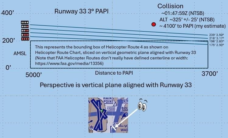
Re the height deviation. When flying a helo at 200ft at night over a black hole (the river) you are very conscious indeed of your extremely low height. If told of conflicting traffic that you have to search for over/amongst city lights your attention is considerably diverted from pure flying and the natural tendency would be to squeeze back a little on the cyclic. I imagine that would be even more the case if NVGs were in use, tho I've no experience with them. That is a likely cause of the otherwise surprising altitude deviation tho we'll never know.
Subjects
Night Vision Goggles (NVG)
Route 4
Links are to this post in the relevant subject page so that this post can be seen in context.
Reply to this quoting this original post. You need to be logged in. Not available on closed threads.
February 17, 2025, 12:54:00 GMT
permalink Post: 11829882
If everyone had been flying at the prescribed altitudes, the CRJ should have passed 40ft over the Blackhawk, I can't believe that would have been OK.
I was very surprised also to hear Jennifer tell us that the heliroutes have no lateral boundaries, which is a bit bizarre given that the Route 4 in the notes on the chart is described as following the East bank of the Potomac which is about on the left end of the diagram. Doesn't matter though, same problem there. Routes shouldn't be designed so that aircraft can infringe on landing (or any other kind) of passenger jet traffic.
Subjects
Blackhawk (H-60)
CRJ
Route 4
Links are to this post in the relevant subject page so that this post can be seen in context.
Reply to this quoting this original post. You need to be logged in. Not available on closed threads.
February 17, 2025, 15:50:00 GMT
permalink Post: 11829979
As many and I said before, discussion about Altimeters or width of VFR routes are just distractions to deflect from the real cause , which for me can be resumed into the lack of a safety assessment and safety case of existing procedures. We all had to do this when SMS was widely introduced in the late 90s It was not that easy , but we discovered a few holes that were closed.
Here in DCA we see a couple of procedures that would not have passed a safety case : e.g Route 4, Circling to RWY 33 with that route active, visual separation at night , use of NVG on that route ..etc,,
Flying in itself always bares a risk,, our job is to minimize the risk , not to eliminate it , but here the Regulatory ( i.e FAA) failed to minimize the risks.
As in the US the FAA is both the service provider and the Regulator , and is in addition dependent of political will and pressure for its funding , the willingness to implement unpopular measures, may be limited. A Judge might look into this differently but for those part of the discussion I hand over the floor to .Willow run 6-3 .
This is an excerpt from a website of an actually well-known, very accomplished, and respected group of lawyers who specialize in (among other things) aviation matters. I'm not using their name and I don't have any approval, express or implied, to use information from their website - but if justice is to be sought for the victims' families, public discussion is - or should be - encouraged.
"A discretionary function is an action of a governmental nature exercised by a federal employee, but in order for that action to be considered a discretionary function, it must pass a two-part test:
There must be an element of judgment or choice. That is, if a federal statute or regulation prescribes a course of action for an employee to follow, there is no discretion.
That judgment or choice must be susceptible to policy analysis.
The Federal Tort Claims Act contains a discretionary function exception that says the U.S. cannot be held liable for any employee\x92s failure to exercise or perform a discretionary duty.
Within the legal field of aviation accidents, discretionary duties for which the U.S. is not liable include the following:
Aircraft \x93spot check\x94 certifications
Weather forecasting
Failure to install equipment
The FAA\x92s design of flight procedures
The types of actions that are considered not discretionary, and therefore, open the U.S. government to litigation are:
The failure to issue air traffic control manual warnings
If air traffic control fails to warn of weather dangers
The failure to maintain equipment
Relaying incorrect instructions to pilots."
END OF EXCERPT [not intended as legal advice here or on its original internet page]
So to return to ATC Watcher's point...... the more posts I read about this midair collision (plus other information such as NTSB briefings) the more I am anticipating that it will require an act of Congress to provide for compensation for the families of the victims. Isn't it the obvious fact that convenience for people who work in Washington and travel "back home" generally speaking on weekends and when Congress isn't convened, is a prime and central reason for the way DCA airspace has been constructed and managed? Is it really going to be the case that because the lawsuits will - in all likelihood - fail to overcome the "discretionary function" exception, that the 67 families will be without a remedy? Is that how it works, then?
In case anyone thinks my sense of being horrified at this accident is clouding reason or logic, consider this - the book Collision Course discusses the PATCO union's genesis, the strike, and so on. PATCO's earliest stirrings resulted in large part from the 1960 midair over New York. Is the United States aviation sector willing to accept an outcome of this accident that in effect travels back over six decades? The point is, given the long-term shortage of ATCOs in this country . . . I don't think a court is capable of ruling that the situation, allowed and in fact enabled by Congress and successive White House presidential administrations, is subject to "negligence" analysis in the currently applicable legal sense. All this being said, this is how I arrive at thinking that in the interests of justice, some other means of providing for the loved ones of 67 souls who were on board needs to be determined and implemented.
Last edited by WillowRun 6-3; 17th February 2025 at 19:11 .
Subjects
ATC
DCA
FAA
NTSB
Night Vision Goggles (NVG)
Route 4
Separation (ALL)
VFR
Visual Separation
Links are to this post in the relevant subject page so that this post can be seen in context.
Reply to this quoting this original post. You need to be logged in. Not available on closed threads.
February 17, 2025, 21:32:00 GMT
permalink Post: 11830196
Here if you want to learn or just refresh your memory ; https://www.latimes.com/archives/la-...%20government.
As an aside , the NTSB conclusions of that collision are interesting compared to our DCA accident : ( exactly 40 years ago !)
Subjects
ATC
DCA
FAA
NTSB
Probable Cause
Route 4
See and Avoid
Separation (ALL)
Links are to this post in the relevant subject page so that this post can be seen in context.
Reply to this quoting this original post. You need to be logged in. Not available on closed threads.