February 19, 2025, 22:00:00 GMT
permalink Post: 11831783
Added note: The chart shows only crossings collected with ADS-B. I threw out all MLAT collected crossing because of inherent inaccuracy.
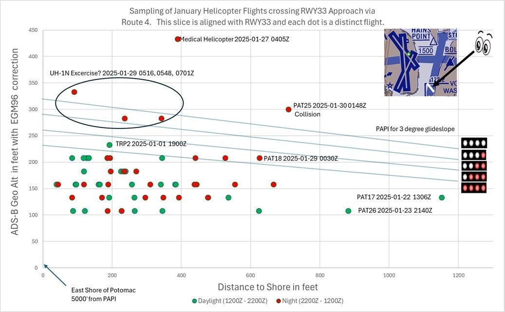
Helicopters crossing RWY 33 approach via Route 4 for January
Last edited by airplanecrazy; 19th February 2025 at 22:26 .
Subjects
ADSB (All)
ATC
Route 4
Links are to this post in the relevant subject page so that this post can be seen in context.
Reply to this quoting this original post. You need to be logged in. Not available on closed threads.
February 19, 2025, 23:16:00 GMT
permalink Post: 11831829
Added note: The chart shows only crossings collected with ADS-B. I threw out all MLAT collected crossing because of inherent inaccuracy.
Helicopters crossing RWY 33 approach via Route 4 for January
Interesting to note that, had PAT25 been at 200 ft and the CRJ just slightly below nominal glideslope, they would have collided too.
And that, had the CRJ been on the glide slope, it would have been way below PAT25 and would not have collided
Last edited by Senior Pilot; 20th February 2025 at 04:17 . Reason: Tidy up
Subjects
ADSB (All)
ATC
CRJ
PAT25
QNH
Route 4
Links are to this post in the relevant subject page so that this post can be seen in context.
Reply to this quoting this original post. You need to be logged in. Not available on closed threads.
February 19, 2025, 23:33:00 GMT
permalink Post: 11831851
(I've assumed that the altitude is recorded in the closest bin to the actual value. If that's not the case then the error bars would be 25 feet in one direction or the other depending on whether it rounds up or down. An ADSB geek would know. I am also itching to know whether the origin point of your glidepath lines has been adjusted to the same EGM96 height datum as the ADSB values...)
As for your question on the glideslope, I did NOT properly account for the EGM96 correction. The new chart moves the glideslope up 5' to meet the height of the PAPI as measured in Google Earth (18'), which uses EGM96. Is that reasonable? I should also add a couple of feet to account for the height of the PAPI lights themselves. Does anyone know how much I should add? Thanks for the catch.
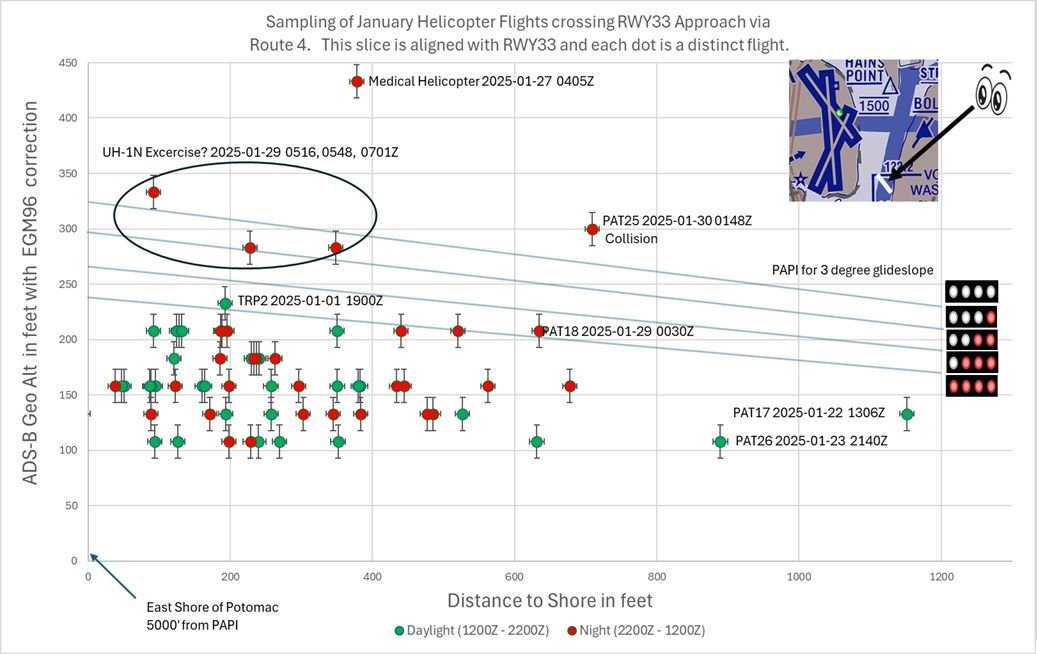
Helicopters crossing RWY 33 approach via Route 4 for January (updated)
Last edited by airplanecrazy; 19th February 2025 at 23:49 . Reason: Adjusted PAPI lights up 5 feet
Subjects
ADSB (All)
Route 4
Links are to this post in the relevant subject page so that this post can be seen in context.
Reply to this quoting this original post. You need to be logged in. Not available on closed threads.
February 27, 2025, 00:15:00 GMT
permalink Post: 11836728
The chart for route 4 shows a single line above 200 ft indicating its the maximum permissible altitude. Also the wording on the chart is "at or below". IF, as the video suggests, 200 ft was the only recommended altitude then I would expect it to have a line above and below it with the appropriate wording "at" only. Route 6 has a 1500 ft altitude with a line above and below and with "at" only in the wording.
From the FAA chart I believe altitudes below 200 ft are permissable and expected along route 4.
Subjects
FAA
Route 4
Links are to this post in the relevant subject page so that this post can be seen in context.
Reply to this quoting this original post. You need to be logged in. Not available on closed threads.
February 27, 2025, 00:32:00 GMT
permalink Post: 11836735
The chart for route 4 shows a single line above 200 ft indicating its the maximum permissible altitude. Also the wording on the chart is "at or below". IF, as the video suggests, 200 ft was the only recommended altitude then I would expect it to have a line above and below it with the appropriate wording "at" only. Route 6 has a 1500 ft altitude with a line above and below and with "at" only in the wording.
From the FAA chart I believe altitudes below 200 ft are permissable and expected along route 4.
Army: Do not go below 200 feet.
Flying at 200 feet is the only way not to have one of the two annoyed with you

Subjects
FAA
Route 4
Links are to this post in the relevant subject page so that this post can be seen in context.
Reply to this quoting this original post. You need to be logged in. Not available on closed threads.
March 10, 2025, 20:46:00 GMT
permalink Post: 11844860
For Low Observable: no, it's called "an overreaction"
- Military organizations and government organizations have a long history of doing stuff like that.
However, if you look at facts on the ground: Helos using Route 5 routinely followed I-395 and hooked around the east side of the Pentagon, which is closer to the RW15 piano keys than Route 4 is to RW33. Moreover, that stretch of roadway is elevated and has high-level lights, so the space under 200ft relative to river or runway level is that much tighter.
I also wonder how Route 5 traffic got tracked on DCA radar given high buildings and the Arlington ridge. .
Last edited by LowObservable; 10th March 2025 at 22:14 .
Subjects
DCA
Radar
Route 4
Route 5
Links are to this post in the relevant subject page so that this post can be seen in context.
Reply to this quoting this original post. You need to be logged in. Not available on closed threads.
March 11, 2025, 20:08:00 GMT
permalink Post: 11845606
Existing separation distances between helicopter traffic operating on Route 4 and aircraft landing on runway 33 are insufficient and pose an intolerable risk to aviation safety by increasing the chances of a midair collision.
When Route 4 operations are prohibited as recommended in Safety Recommendation A-25-1, it is critical for public safety helicopter operations to have an alternate route for operating in and around Washington, DC, without increasing controller workload.
To the Federal Aviation Administration:
Prohibit operations on helicopter Route 4 between Hains Point and the Wilson Bridge when runways 15 and 33 are being used for departures and arrivals, respectively, at Ronald Reagan Washington National Airport. (A-25-1) (Urgent)
Designate an alternative helicopter route that can be used to facilitate travel between Hains Point and the Wilson Bridge when that segment of Route 4 is closed. (A-25-2) (Urgent)
Subjects
ATC
Findings
KDCA
Route 4
Separation (ALL)
Links are to this post in the relevant subject page so that this post can be seen in context.
Reply to this quoting this original post. You need to be logged in. Not available on closed threads.
March 20, 2025, 15:18:00 GMT
permalink Post: 11850721
Personally, the reference to ASIAS and it forming a key player here is, IMHO, a bit of a "red herring". It's not how Flight Safety should work in my experience of over some 40 years. Flight Safety ethos comes from the top and works down. Flight Safety activity starts at the bottom works up. In other words, it is the guys and gals on the Line, in the Tower, in the Hangar, in the Cockpit day-to-day who should actively spot and flag up issues relevant to where they are working - encouraged and supported all the way by the ethos from on high. After all, they (and only they) know exactly what is happening in their airspace, on their flight deck, in their hangar.
So the \x93DCA Flight Safety Organisation\x94 (we had Flight Safety Committees as Sqdn and Stn level to manage this \x96 similar in Industry \x96 so does DCA have a similar group? Please tell me it does!) should have been alerted to, possibly, initially unquantified issues with near misses along Route 4 by ATC staff. Local DCA Safety Management and ATC staff would then quantify the issue using the data available directly from such sources as the FAA AIDS and the NASA ASRS databases, all freely available via the ASIAS site. A good overview of ASIAS can be found here and an example of a search screen is the AIDS search form. This is all driven \x93bottom up\x94 . I personally used AIDS and ASRS during my MSc when writing a research paper many years ago \x96 sat at my PC in the UK so it\x92s really easy to use if I could master it! Juan probably got his stuff from there too.
Once the \x93DCA Flight Safety Organisation\x94 has looked at the data sources, either you have no issue or it needs wider investigation. In this case, clearly it was an issue, so (a) Route 4 should have had temporary mitigation put in place by DCA and (b) the "corporate" FAA (for want of a way to describe it) should have been requested to carry out a full "independent" Safety Review. Finally, (c), the ASIAS organisation could have been asked to flag this up to other Airfield Safety Organisations in their \x93Communication\x94 role in case they had similar issues to DCA. Again, local Safety Management at those fields would then investigate.
The FAA Safety Review should decide, with justification , what the next steps are - the justification being called the revised Safety Case (\x93revised\x94 as there should already be an initial \x93Safety Case\x94 supporting the operation of Route 4! Mmmm, an initial Safety Case? Was that a pig I\x92ve just seen fly past here???????!!!!!!!!). The outcome could be (as in this case) to close Route 4 down. If it were to be kept open, the revised Safety Case must support that by adding further mitigation and, vitally, the situation should be then be formally reviewed at defined intervals to ensure such mitigation is actually working before it becomes \x93normal business\x94. The FAA could also order a much wider formal review to see if other airfields are similarly affected and, if so, similar Safety Case reviews should be conducted at such locations if required.
So, from my point of view, I think that ASIAS (and as per the ASIAS overview link earlier) is not in itself responsible for initially identifying issues - it is simply (a) a conduit across users once issues have been identified by a user and (b) it manages some tools for users to use. I managed the RN\x92s Fleet Air Arm Engineering Database with a staff of 3. What we would do is, for example, at the request of Equipment Desk Officers , run additional reports requested by them if they thought, say, there was an increase in issues with a particular type of hydraulic pump or whatever it was. It was not my role in that Post to look for problems - my role was to ensure such data was accessible and ensure the database remained accurate and up to date. As I said earlier, the activity to raise problems and initially scope them is bottom-up as only the worker-bees (in my example, the Desk Officer) see the specific issues where they happen to work. The ethos to ensure that the organisation is in place at each airfield (and the wider FAA) to support the Safety activity should be top-down.
Clearly, it requires suitably qualified/experienced people on the coal face with a mind to safety to actively recognise and flag up such issues, encouraged from the very top by the ethos . That is an important point. If the ethos \x93encourages\x94 the watching of a \x93near miss\x94, sucking one\x92s teeth and saying \x93Sheesh! That was bleep-bleep close!!!!\x94 and moving swiftly on, that is NOT a safety management ethos !!! That is a recipe for disaster! If the ethos exists only in name and the worker-bees are not positively encouraged to raise issues which are then transparently acted on, but is an ethos which is totally subservient to commercial or political pressures then you'll get little or no Safety activity which will lead to\x85\x85\x85.... I\x92m sure you can all fill that ending in\x85\x85\x85!
Just my thoughts FWIW\x85\x85.. and sorry it\x92s so long!
 Cheers
H 'n' H
Cheers
H 'n' H

Last edited by Hot 'n' High; 20th March 2025 at 15:35 .
Subjects
ATC
Close Calls
DCA
FAA
NTSB Chair Jennifer Homendy
Route 4
Links are to this post in the relevant subject page so that this post can be seen in context.
Reply to this quoting this original post. You need to be logged in. Not available on closed threads.
March 21, 2025, 11:20:00 GMT
permalink Post: 11851281
I always read you input as, while the detailed legal nitty-gritty is generally way beyond me, you always provide a refreshing viewpoint which is good to read! The aim of my Post, based on my interpretation of the above quote, was just to emphasise the existence of ASIAS is just as a tool or, rather, a set of tools but which has no real "proactive function" in itself. Yes, it represents a very small part of the Flight Safety chain - but as a resource in the main. As you say, there were loads of examples of what happened at DCA and my post was an explanation as to who, I believe, should have been looking at it. Maybe they did - and just ignored it? No idea!
In the UK, the airport operator is totally responsible for the safety of operations on or above their field out to 4000 ft on approach and departure - about 12 miles. The CAA who regulates aviation here, along with the Dept of Transport, but in conjunction with other stakeholders such as NATS (our en-route ATC organsiation), airlines and airfield operators etc, designs the airspace and sets the generic rules for it's use. As you said, the main rule is "Don't crash anything into anything else!". However, at the airfield, it is the airport operator who needs to ensure that the generic rules work in their environment. If a particular rule is legal but, if applied in their location, is unsafe, they can't apply that rule! That's what the Safety Case should say.
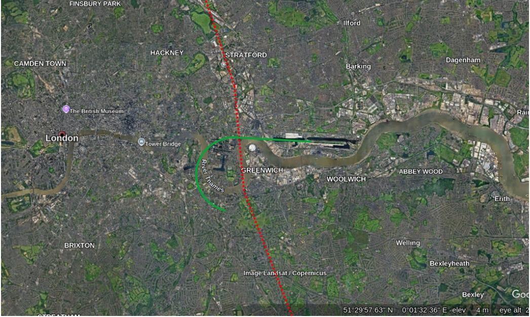
A relevant example? I used to regularly (for work) transit London S > N and N > S along the red dotted line below - at 2400ft as it kept me just out of the London TMA but as high as possible so, if it had all gone quiet on the engine front, I'd have the best chance to get the plane onto the ground with me alive and no-one else hurt. As part of the transit, I had to cross the final approach into London City (green line). So, say heading N, I'd chat to Thames Radar while over South London and would ask for a London City crossing. They'd chat to City ATC to co-ordinate and take me to the Thames before handing me to City Tower. My route over the Approach has aircraft at 1200 ft descending on the ILS and so I would have crossed anything landing at 1200 ft above that. So, while on first glance, it was fine I never, ever got that clearance with an aircraft landing - and for very good reasons. If the aircraft on the ILS had had to do a go-around, life could have become interesting very quickly. I was always held until the landing aircraft was well clear (ie ATC could see it was almost at the airfield) before they cleared me across. Indeed, legally, they could have given me a "You see the landing? Pass behind that"! But, no - always positive clearances. Got my vote ....... + gave me chance to enjoy the views of Greenwich and the City of London and "delayed" me a couple of minutes. OK, a bit unfair as LCY is "sleepy hollow" compared to DCA but, despite that, they were very friendly ..... but very strict!!!!!
So, when you are discussing (I think!!!) whether ATC elected to give PAT25 a "You visual? Pass behind" or whether it was "ordered" from on-high as it was deemed safe to do, ultimately, it is the ATCOs call on the day. Now, before I get flamed, do I blame the ATCO ? No! Well, why not? After all, he gave PAT permission! And yes, it was a "legal" clearance. But was it a wise clearance? When unpacking that little lot you have to look at a raft of Human Factors which influenced that ATCO on that night. He was on his own so, probably, the only way he could cope with all he had on his plate was to try and shift some responsibility onto PAT25 - one less thing for him to juggle. But even then, he needed to be monitoring which he clearly was - but while very busy with other approaches and departures so he just picked up a concern too late as the audio shows - "Are you sure you see the jet?". Another factor - was the strategy to use Route 4 while 33 was active something ATCers at DCA, over time, started in an effort to cut down radio traffic and speed things up? If so, had it been assessed and then monitored for adverse safety? While anecdotally, it seemed people were aware of "close calls", had any analysis taken place looking at the Databases? In the UK certainly, all the Airport Operator responsibility.
To the final "accountability" part re payments to families, the thing we have here is (and, folks, correct me if I've got this wrong) the FAA set the rules and the operate the Rules. Here, the CAA sets the rules and the Airfield Operator operates the rules. That is important - for eg, huge argument here in the UK about just how independent the UK's Military Flight Safety organisation is ..... as it is part of the Military. IMHO, what we have here are valid generic rules, some of which were simply not suitable in this specific location - just like crossing London City with an aircraft on approach - legal ...... but very unwise. As to who carries the can, well, as you said WR 6-3 , the legal beagles will get to the bottom of that ..... but it will take some time. I'll leave that side to you!!! My main question out of all of this is, why were not these issues flagged up by airport management for further investigation given it was something of an open "secret"? And where else (around the world) is this happening?

And, on that cheerful note...........! H 'n' H
Subjects
ATC
ATCO
Accountability/Liability
Close Calls
DCA
FAA
PAT25
Pass Behind
Pass Behind (All)
Radar
Route 4
Links are to this post in the relevant subject page so that this post can be seen in context.
Reply to this quoting this original post. You need to be logged in. Not available on closed threads.
March 22, 2025, 01:07:00 GMT
permalink Post: 11851803
". . . was the strategy to use Route 4 while 33 was active something ATCers at DCA, over time, started in an effort to cut down radio traffic and speed things up? If so, had it been assessed and then monitored for adverse safety? While anecdotally, it seemed people were aware of "close calls", had any analysis taken place looking at the Databases?"
To start, no apology whatsoever needed with regard to this dialogue. I try to respect the decorum required on this forum generally (meaning as SLF/attorney something has to be pretty severe or awful to warrant apologizing to me). And although I might not explain my sense of this with enough clarity - the FAA is conducting a review (according to Secretary Duffy) of airspace management and usage rules at other airports. The explanations in your posts, including very particularly the procedures when crossing approach corridors for London City, should be read and studied by the presumably well-informed professional ATO (Air Traffic Organization) staff assigned to conduct the review. (If it seems way presumptuous for an SLF/attorney to assert what resources ATO should be considering for the review noted by Sec. Duffy, I would suggest that ATO's reputation at the moment for upholding the much-touted "gold standard" set by FAA and United States aviation in general for the rest of the world ... well, like we used to say in trial practice, it takes the other side only about three minutes in court to stain the draperies, but it will take us all afternoon even to try to clean them. Reputation lost, same deal getting it back.)
On ASIAS, actually I entirely agree with your description of where it fits into the so-called "aviation safety ecosystem" (there simply has got to be a better term). The point I'm stuck on is one that (apologies, once more) comes from litigating in U.S. courts (especially federal District Courts around the country) employment law cases. Specifically, at the start, the main task for defense counsel is to construct the "chronology". Who did and said what to whom, when, and for what reason(s). I've asserted in an earlier post that in what I see as the inevitable litigation arising from this accident, there will be teams of significant lawyers constructing, or attempting to construct, such a chronology, although it won't be about an individual employee's hiring, performance reviews, promotion grants or denials and so on. It will be how it happened that the situation which obtained in the DCA airspace, in the cockpits of the Blackhawk helicopter and the CRJ, and ATC, came to exist.
(And I say "significant lawyers" because the attorneys who handle the big and significant aviation crash lawsuits for the families of victims are kind of the polar opposite of the stereotype ambulance chaser; to the contrary, their work is opposed by big-time big-law firm skyhigh hourly rate legally privileged sharks. The lawyers suing on behalf of these crash victims - if they are the same as the legal specialists I have met and discussed stuff with in various settings - are vindicating the need to bring the truth to light. "Aviation is the safest form of transportation": it is incanted over and over to the point of making anyone who utters it now sound quite seriously performative. Yet if it is so safe, how and why did those 67 people die over and in the Potomac? So with a kind of intense ruthlessness, the lawyers who will represent the families and other loved ones of the crash victims will unearth every little sequential act and omission which led to the situation which obtained on the fateful night of Wednesday, 29 January 2025. Exactly as the quoted language above from your post asks, what indeed was the strategy, if there even was one, as opposed to little incremental changes, accelerated of course by increasing airline flight lengths under the perimeter rule.)
On this basis, I would not concur with the idea that whether immunity is available for the defendants (both the Army and FAA/DoT) depends on whether the ATCO's specific conduct on Jan. 29 was "ordered" from on-high. The "on-high" is the development, over time, of the situation that obtained that night at DCA, despite safety imperatives in the NAS and aviation sector in general - and not a specific order or instruction given on that night.
The question behind the discretionary function exception is whether the act or omission by the defendant either (1) was negligent because it failed to follow a specific rule or statutory provision (if so, no immunity), or (2) was negligent in the usual sense of the word but will nevertheless still be protected by immunity because the act or omission was based on a decision about a policy matter or question. The decision on the policy matter or question is "discretionary" on the part of the government and hence the name of the exception protecting it. The courts are reluctant, and sometimes loath, to second-guess policy decisions made by the Executive Branch (I know, irony neither intended or not intended, given certain prominent flight- and aircraft-related matters in federal court at the moment). Under the first variety of negligence, there was no policy matter being decided, just failure to do something there was a legal duty to do (basic definition of negligence). Under the second variety, there would be a valid case to be made that there was negligence - but the immunity provided by the exception for discretionary functions prevents the case going forward.
So back to January 29, the assertion I've been making here is that no, there was not a specific rule or procedure that said to do things much like you describe the procedure - de facto (unwritten, informal) though it was - for transiting across the approach path. But there certainly were higher-order rules by which FAA and its ATC functions were required to observe in consistent performance, and not merely in repeated incantation that "aviation is the safest form of transportation." In fact, I wonder if clever lawyers might take that slogan and deploy it as a bludgeon. "You're at greater risk driving your car to the airport", they always say. Oh, really? Then let's talk about the equivalent scenario on the streets of Chicago with intersecting traffic lanes (obviously not at different altitudes), similarly difficult visibility conditions at night, compounded by NVGs. possibly compounded by a training or check ride in the vehicle, and then make the case that the Chicago PD cop directing traffic, and the motorist without the right-of-way, were acting on the basis of interpreting policies about driving on public roadways. No, there is no policy matter involved - there are strict rules of the road and over-riding principles for safe driving, and the failure to observe these is negligence.
It's simplistic but it might be sufficiently illustrative. Is "see and avoid" a procedure which involves making decisions on matters of policy? or is it a higher-order safety rule which must be observed at all times?
(Not meaning to slight the point about ANSP and regulatory functions needing to be separate - entirely agree, and yet, this will be an extraordinarily heavy lift to get done in the United States. That being said, I might know some lawyer-types who are fired up about efforts to make it happen this time around.)
WillowRun 6-3
Subjects
ATC
Blackhawk (H-60)
CRJ
Close Calls
DCA
FAA
Night Vision Goggles (NVG)
Route 4
See and Avoid
Links are to this post in the relevant subject page so that this post can be seen in context.
Reply to this quoting this original post. You need to be logged in. Not available on closed threads.
March 22, 2025, 05:51:00 GMT
permalink Post: 11851870
The local controller had an Assistant ATC and a Supervisor to coordinate, monitor and regulate the traffic.
Class B airspace "ATC Clearances and Separation. An ATC clearance is required to enter and operate within Class B airspace. VFR pilots are provided sequencing and separation from other aircraft while operating within Class B airspace." source FAA Class B
One way to determine how the application of sequencing and separation to VFR pilots in this airspace was being applied would be to listen to the audio and watch radar replays over the weeks and months prior.
Subjects
ATC
Close Calls
DCA
FAA
PAT25
Radar
Route 4
Separation (ALL)
VFR
Links are to this post in the relevant subject page so that this post can be seen in context.
Reply to this quoting this original post. You need to be logged in. Not available on closed threads.
March 22, 2025, 12:48:00 GMT
permalink Post: 11852019
Of course in this case the thing known to degrade safety is "see and avoid", the regulator is the FAA, and the relevant parts of the user community appear to be "near as damn all of it". Focusing on the Army pilots' failure to achieve it would be a neat distraction from the much more difficult question (for everyone) of whether it is an appropriately safe means of separating from airline traffic. The nice NTSB diagram of Route 4 and the 75 feet spacing dodges the issue that neither the controller nor the Army pilots assumed that procedural separation existed; visual separation was being applied.
The permanent closure of Route 4 could be seen as acceptance that this was an unsafe basis on which to permit operations. However it still misses the point. The route was capable of being operated safely, for instance by holding helicopter traffic or avoiding use of runway 33 when needed to prevent conflictions, but that would have been tacitly to accept that visual separation was unsafe. Closing the route also only fixes the issue on one runway at one airport. Where next?
Last edited by Easy Street; 22nd March 2025 at 13:08 .
Subjects
ATC
FAA
NTSB
Route 4
See and Avoid
Separation (ALL)
Visual Separation
Links are to this post in the relevant subject page so that this post can be seen in context.
Reply to this quoting this original post. You need to be logged in. Not available on closed threads.
March 23, 2025, 10:35:00 GMT
permalink Post: 11852551
As for your question on the glideslope, I did NOT properly account for the EGM96 correction. The new chart moves the glideslope up 5' to meet the height of the PAPI as measured in Google Earth (18'), which uses EGM96. Is that reasonable? I should also add a couple of feet to account for the height of the PAPI lights themselves. Does anyone know how much I should add? Thanks for the catch.
Helicopters crossing RWY 33 approach via Route 4 for January (updated)
75' is plainly inadequate vertical clearance between two aircraft and doubling/tripling that would still be unacceptably close. Separation was surely expected to be achieved horizontally but the enforcement/implementation was lacking.
Subjects
ADSB (All)
Route 4
Separation (ALL)
Links are to this post in the relevant subject page so that this post can be seen in context.
Reply to this quoting this original post. You need to be logged in. Not available on closed threads.
March 25, 2025, 11:53:00 GMT
permalink Post: 11853844
Agreed 100%! After all, many air accidents are because pilots are in the wrong place - a good example is the current sister Thread to this one covering a plane which started to take-off from a taxiway - sadly a regular occurrence. Lots of people are asking "How on earth......." - but they did, just as others have done before them! I'll not comment further as the discussion is on that Thread anyway which you can read and the Investigation is early days so far.
However, one of the reasons aviation is so safe today is because the aviation community realised a big driver to improving safety, based on the premise that humans are both ingenious in devising new ways to screw things up - as well as being quite capable of repeating the old ways too - was to understand if additional issues were contributing to those accidents. In particular, anonymous self-reporting of "near misses" provides much valuable information enhancing the understanding of issues before anyone dies. There were many "near miss" reports relating to this route/runway as has been mentioned. But no-one joined the dots........
By understanding how those additional factors contributed to the near miss/accident means further mitigation could be put in place. Maybe one of the most significant - Flight Time limitations - have come about as, after a number of accidents, people realised just how a lack of proper rest significantly degrades human performance and so contributed to poor decision-making, particularly when under pressure. I just use that as an example of "contributory factors" - possibly not relevant here - the full Report is not out yet.
In this case, the helo crew ended up flying into a jet. But why did they do that? Well, when the NTSB recommended that Route 4 be closed, it described it as being "an intolerable risk to aviation safety by increasing the chance of a midair collision.". If the helo crew mistook another aircraft to one they should have been avoiding (a likely mistake) there was little effective mitigation to prevent that mistake leading to catastrophe - hence the recommendation from the NTSB. What there was in terms of mitigation - such as the ATCO - failed. The ATCO suddenly realised all was not quite right but he didn't have the time to come up with a solution to save the day and a collision happened on "his watch". I can't even imagine what he is going through right now every single day.....
Yes, by all means decide liability for recompense to those who lost loved ones on that fateful day - (top tip, go where the money is!). The legal people like our esteemed fellow PPRuNer, WillowRun 6-3 , will do that. What the aviation community itself wants to ensure is that such a mistake (which will happen again - as I said, whilst humans are extremely inventive in finding out new ways to screw up they are also prone to be quite capable of repeating mistakes ad infinitum) - never leads to such deaths in the future. That's why people look, in great depth, behind the obvious cause for the crash to see what more can be done. That's why it's so safe for you to step aboard an aircraft today.
To reiterate, in the words of the NTSB, the aviation world was running a route which provided "an intolerable risk to aviation safety by increasing the chance of a midair collision.". So, one question, who approved that ..... and where is the Safety Case to support that decision? Cue tumbleweed rolling slowly down the road......................
I hope this helps explain why it's wayyyyyy more than "The crew screwed up. End of story!". Cheers, H 'n' H
Subjects
ATCO
Accountability/Liability
Close Calls
NTSB
Route 4
Links are to this post in the relevant subject page so that this post can be seen in context.
Reply to this quoting this original post. You need to be logged in. Not available on closed threads.
March 26, 2025, 08:10:00 GMT
permalink Post: 11854380
Here is the NTSB report/transcript and another transcript here . I couldn't locate the one on Prune way, way back but these 2 will do!). ATC specifically call the a/c sidestepping to 33 as the a/c PAT needs to identify. The ATCO even tells PAT what type it is. PAT then say they have "it" visual. Sadly, "it" wasn't the sidestepping a/c, it was another one. But no-one figured that out ...... till seconds before the crash. This initial exchange, according to the transcript, was about 2 min before the collision. It's only then, on the basis that PAT says they have seen "it" and, by implication, will visually avoid it, that ATC issue the clearance on down Route 4.
There was a lot of discussion earlier on in this Thread about how on earth PAT could be reliably expected to pick out the subject a/c from the rest of the stream of arrivals and at that distance (6 miles rings a bell).
It's only seconds before the crash that it appears that the poor ATCO suddenly starts to suspect the PAT crew are actually looking at a different a/c to the one he had asked them to identify and pass behind. But, by then, it was too late for him to figure out a solution to give to PAT.
As I said, this was all discussed many posts ago so it's easy to forget the details. Hope the links help!
Cheers, H 'n' H
Last edited by Hot 'n' High; 26th March 2025 at 08:44 .
Subjects
ATC
ATCO
NTSB
Pass Behind
Pass Behind (All)
Route 4
Links are to this post in the relevant subject page so that this post can be seen in context.
Reply to this quoting this original post. You need to be logged in. Not available on closed threads.
March 26, 2025, 21:06:00 GMT
permalink Post: 11854747
Subjects
ATC
CRJ
PAT25
Preliminary Report
Route 4
Links are to this post in the relevant subject page so that this post can be seen in context.
Reply to this quoting this original post. You need to be logged in. Not available on closed threads.
March 26, 2025, 21:43:00 GMT
permalink Post: 11854783
Subjects
PAT25
Preliminary Report
Radar
Route 4
Separation (ALL)
Visual Separation
Links are to this post in the relevant subject page so that this post can be seen in context.
Reply to this quoting this original post. You need to be logged in. Not available on closed threads.
March 29, 2025, 12:08:00 GMT
permalink Post: 11856609
How would the successful transmission of ADSB Out information by the Blackhawk have changed the outcome on January 29?
After watching the US Congress \x93grill\x94 the military, FAA and NTSB how could they participate in a conspiracy of silence\x85
The NTSB will be seen as either very dumb or deceitful or both.
Now what was the number of the Q ANON Pizza shop, I feel like some truth tonight.
Send it to me via Signal. What a joke! The relatives of the crash victims were there to watch the farce.
I'm all ears, excellent point. This focus on ADSB-OUT, and ADSB-IN is really a furphy in terms of this investigation to determine the facts, the whole facts and nothing but the facts.
If 5342 had ADSB-IN then PAT25 not having or not displaying ADSB-OUT could be relevant depending on 5342's cockpit display, the training of the pilots and their scanning.
5342 didn't have ADSB-IN so move along, move along, nothing to see, these aren't the droids you're looking for.
**Caveat. If the TWR display were using ADS-B for their updates and to generate Collision Alerts then the absence of PAT25 ADSB-OUT could be relevant.
But would the TWR ATC even know (or care) whether PAT-25 was ADSB-OUT capable. TWR ATC involves looking out the windows and judging the relative positions of aircraft.
Note: ATC display systems are not referenced in the NTSB Aviation Investigation Preliminary Report. This seems to be a glaring omission. So perhaps the NTSB are either very dumb or deceitful or both.
To further illustrate the focus on ADSB. Figure 1 Google Earth image with preliminary ADS-B data for flight 5342 and radar data for PAT25.
The ADS-B plots are 1 seconds intervals, the radar data are 4 second interval (as stated during US Congress Q&A).
So the focus is on the whizz bang ADS-B kit rather than what the ATC saw on their display.
There is reference to ATC radios, and 5342 was on frequency 119.1 MHZ and PAT25 was on frequency 134.35 MHZ. The ATC could've had them on the same frequency (changed PAT25 to 119.1 MHZ) but this would be abnormal. ATC Voice Switch systems like Frequentis, SITTI and Rohde & Schwarz typically have a frequency coupling, whereby controller broadcasts on multiple frequencies (2 or more) and voice communications on one frequency are heard on the other. In this case, ATC would broadcast on 119.1 MHZ and 134.55 MHZ and 5342 would hear instructions for aircraft on 134.55 MHZ, and PAT25 would hear instructions for aircraft on 119.1 MHZ.
Dumbo Question 3
As you are no doubt aware TWR Visual Separation is a very powerful tool / method in the eyes of the controller or in the eyes of a delegated pilot. (Literally and metaphorically speaking, i.e pun intended.)
It is the very basis of ATC Aerodrome Control. Sophisticated use requires experience and excellent situational awareness.
I just wonder how many (if any) of the \x93reported\x94 near collisions in the NTSB Preliminary report going back 4 and 14 years respectfully included perfectly safe visual separation?
I just wonder how many of the January Route 4 Helicopter plots crossing RWY 33 Approach (post 1346) were the result of ATC issuing a control instruction to change the track to closer to the shoreline or further over water.
Use of Route 4 during RWY 33 Approaches or RWY 15 Departures is possible providing a clearance limit is imposed prior to assigning relevant traffic, positive control instruction(s) and in the case of 5342, advising them of the relative position of PAT25 and that PAT25 would be maintaining separation from them.
Example for Route 4 southbound would be a clearance limit of Hains Point. Helicopter would be released past this point when there is no conflict (nil traffic) or assigned separation to avoid (pass behind). If there is a in-line stream of arriving traffic then Route 4 may not be available.
Sydney KSA has something similar for one of their helicopter routes - BONDI 5 (yep, named after the beach), delays may occur when RWY 07 is in use for DEP, or RWY 25 is in use for ARR. Further, the route is not available when RWY 16 PRM approaches are being conducted. Sydney KSA helicopter routes are in text form - TRACK TO..., TRACK VIA..., EAST OF..., and the INBOUND routes to Sydney KSA have a clearance limit in the clearance. A map display is very useful however it should be based on route descriptions. Perhaps the committee of 17 knows the history of the helicopter routes in and around DCA.
Subjects
ADSB (All)
ADSB Out
ATC
Blackhawk (H-60)
DCA
FAA
Frequency 119.1
Frequency 134.35
NTSB
PAT25
Pass Behind
Pass Behind (All)
Preliminary Report
Radar
Route 4
Separation (ALL)
Situational Awareness
Visual Separation
Links are to this post in the relevant subject page so that this post can be seen in context.
Reply to this quoting this original post. You need to be logged in. Not available on closed threads.
March 30, 2025, 17:43:00 GMT
permalink Post: 11857453
Because , even if the helo had ADSB out and the CRJ an "in " receiver and a CDTI display , what would have happened then ? . The crew would have spotted the Helo, maybe asked ATC what was that , and the reply of the controller would have been something like : " it is a military helicopter on route 4 , has you in sight , passing behind ." and then would you , flying the CRJ , take evasive action or go around after hearing that ? No .
.
The primary cause of this collision is airspace design and normalization of deviance over the years. I hope the judges will see that when the trial comes. We should leave the military crew and their grieving families out of this.
Subjects
ADSB (All)
ADSB Out
ATC
CRJ
Normalization of Deviance
Route 4
Links are to this post in the relevant subject page so that this post can be seen in context.
Reply to this quoting this original post. You need to be logged in. Not available on closed threads.
March 30, 2025, 21:14:00 GMT
permalink Post: 11857551
.
The primary cause of this collision is airspace design and normalization of deviance over the years.
Some people are making out that if the Helicopter had ADSB-out switched on/ activated, then this would never have happened.
Someone correct me if I am wrong but if the Blackhawk has ADSB-out switched on then nothing changes for the CRJ on that night. The TCAS behaves the same, there is no display of the Blackhawk on the CRJ\x92s Nav display\x85..nothing changes. The CRJ crew are still conducting an approach that requires a lot of fast mental processing close to the ground, at night onto a short runway while ensuring checklists/configuration etc is correct. ie they have a high workload. During this high workload phase, \x91the system\x92 has seen fit to allow a single Human ( the helicopter Captain) to be responsible for the separation of the two aircraft visually, at night, in a busy environment while conducting a check, on NVG\x92s.
Is it likey that a single Human, with the sole responsibility, will make a mistake? It\x92s not just likely, it\x92s inevitable, regardless of how sharp and well trained they are, if you run the program long enough their vision, or their SA will fail them and we get what we got here.
The system should never have devolved to the point where one person accepted the responsibility for visual sep 6nm away, at night, in a busy traffic environment while dealing with their own high workload.
The Blackhawk crew had a high workload, the CRJ crew had a high workload, the ATC had a high workload, there was no fat left in the system. Humans make mistakes and any good system will be tolerant of those mistakes.
The system was not tolerant of a mistake, ergo, the system is at fault.
Subjects
ADSB (All)
ADSB Out
ATC
Blackhawk (H-60)
CRJ
Normalization of Deviance
Route 4
Separation (ALL)
Situational Awareness
TCAS (All)
Links are to this post in the relevant subject page so that this post can be seen in context.
Reply to this quoting this original post. You need to be logged in. Not available on closed threads.