February 07, 2025, 14:59:00 GMT
permalink Post: 11823702
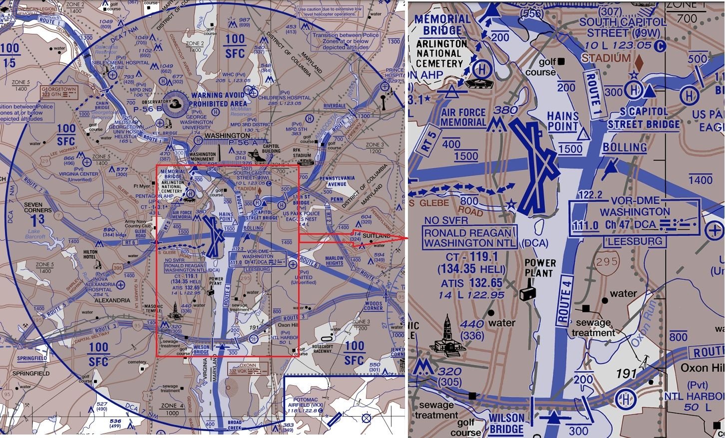
Anything approaching Rwy 1 should be below ~700ft anywhere north of the sewage treatment marker; use the Wilson Bridge for a bit of headroom because not all aircraft are going to be perfectly on glideslope.
The river is far narrower than 1.5Nm so clearly a southbound helicopter on Route 4 can never cross a northbound aircraft approaching runway 1 north of the Wilson Bridge.
You'd have to hold a southbound helicopter north of either the Memorial or Capitol St Bridges until previous traffic had landed. Then have a sufficiently large gap with no arrivals (or departures until south of the runways) for the helicopter to reach the Wilson St Bridge before the next arrival crosses that bridge.
That's the preceding aircraft covering ~3Nm at 140kt (~80s), followed by the helicopter covering ~6Nm at ~100kt (another 3.5min), and accurately timing the next arrival so it doesn't cross the Wilson bridge until after the helicopter, or it needs to do a go-around.
Subjects
Route 4
Route 5
Separation (ALL)
Links are to this post in the relevant subject page so that this post can be seen in context.
Reply to this quoting this original post. You need to be logged in. Not available on closed threads.
February 07, 2025, 15:59:00 GMT
permalink Post: 11823731
Anything approaching Rwy 1 should be below ~700ft anywhere north of the sewage treatment marker; use the Wilson Bridge for a bit of headroom because not all aircraft are going to be perfectly on glideslope.
The river is far narrower than 1.5Nm so clearly a southbound helicopter on Route 4 can never cross a northbound aircraft approaching runway 1 north of the Wilson Bridge.
You'd have to hold a southbound helicopter north of either the Memorial or Capitol St Bridges until previous traffic had landed. Then have a sufficiently large gap with no arrivals (or departures until south of the runways) for the helicopter to reach the Wilson St Bridge before the next arrival crosses that bridge.
That's the preceding aircraft covering ~3Nm at 140kt (~80s), followed by the helicopter covering ~6Nm at ~100kt (another 3.5min), and accurately timing the next arrival so it doesn't cross the Wilson bridge until after the helicopter, or it needs to do a go-around.
Hence the issue requiring metering the helicopters on the numbered Routes.
I don't suggest a hard 1.5NM, but anywhere standard fixed wing ops cannot assure 500' vertical separation, Rotary wing traffic must be gated and controlled.
If rotary wing mission dictates, then fixed wing traffic will have to wait/go missed/discontinue approach. Visual Sep, ATC and a Pavlovian environment killed an airliner.
Subjects
ATC
Route 4
Route 5
Separation (ALL)
Vertical Separation
Links are to this post in the relevant subject page so that this post can be seen in context.
Reply to this quoting this original post. You need to be logged in. Not available on closed threads.
February 28, 2025, 23:10:00 GMT
permalink Post: 11838199
Go-arounds at DCA are a daily occurrence (the Lair is smack underneath the flyout path), sometimes multiple.
Subjects
DCA
Route 5
Links are to this post in the relevant subject page so that this post can be seen in context.
Reply to this quoting this original post. You need to be logged in. Not available on closed threads.
March 09, 2025, 15:21:00 GMT
permalink Post: 11843970
Almost as if there was no safety case behind the PAT operation.
Subjects
Route 5
Links are to this post in the relevant subject page so that this post can be seen in context.
Reply to this quoting this original post. You need to be logged in. Not available on closed threads.
March 10, 2025, 20:46:00 GMT
permalink Post: 11844860
For Low Observable: no, it's called "an overreaction"
- Military organizations and government organizations have a long history of doing stuff like that.
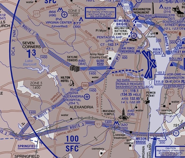
However, if you look at facts on the ground: Helos using Route 5 routinely followed I-395 and hooked around the east side of the Pentagon, which is closer to the RW15 piano keys than Route 4 is to RW33. Moreover, that stretch of roadway is elevated and has high-level lights, so the space under 200ft relative to river or runway level is that much tighter.
I also wonder how Route 5 traffic got tracked on DCA radar given high buildings and the Arlington ridge. .
Last edited by LowObservable; 10th March 2025 at 22:14 .
Subjects
DCA
Radar
Route 4
Route 5
Links are to this post in the relevant subject page so that this post can be seen in context.
Reply to this quoting this original post. You need to be logged in. Not available on closed threads.
March 11, 2025, 03:45:00 GMT
permalink Post: 11845055
Not sure what you mean by this comment. CW3 Roth interview explained the training requirement for Route 1/4 ops. Question is whether these training flights can be conducted safely. I think they can as long as ATC doesn\x92t delegate their primary responsibility for Class B separation. It is politically untenable to resume Route 1/4 PAT training flights at present. I suspect 12th AB and DCA ATC are reviewing their previous policy that VFR visual separation is safe along these routes.
Subjects
ATC
DCA
Route 5
Route 9
Separation (ALL)
VFR
Visual Separation
Links are to this post in the relevant subject page so that this post can be seen in context.
Reply to this quoting this original post. You need to be logged in. Not available on closed threads.
March 11, 2025, 22:29:00 GMT
permalink Post: 11845719
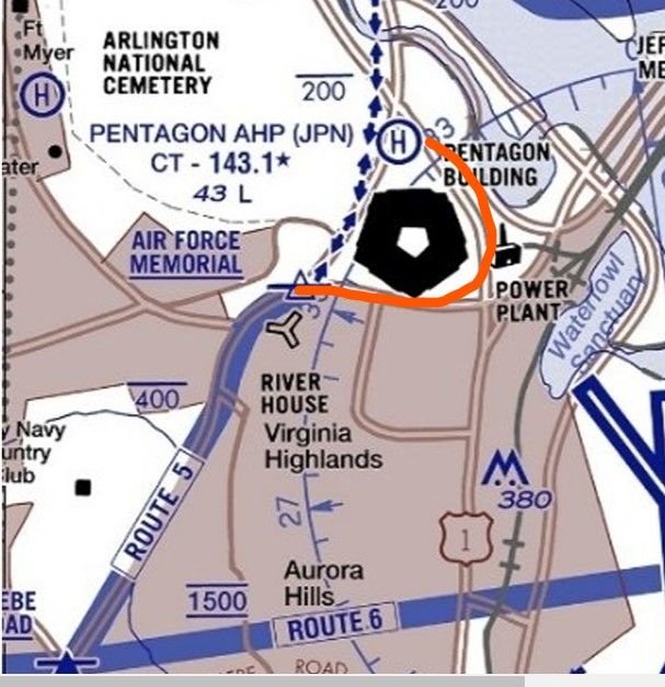
The chart shows the dotted routes connecting 1 and 5 to the Pentagon helipad. But much of the time, the PAT helos would fly the red line - as I observed earlier, over a raised highway with light poles, and cutting under the RW15 approach at about half the distance to the runway end.
I just base this on what I can see locally. I walk almost daily parallel to the rail line and it was no big deal to see the PATs following 395 around the east side of the building - but that's not where the chart says Route 5 is.
By the way a midair over 395 would put debris into a heavily used outdoor sports complex.
PS Observed two more go-arounds from RW18 this afternoon!
Subjects
Route 5
Links are to this post in the relevant subject page so that this post can be seen in context.
Reply to this quoting this original post. You need to be logged in. Not available on closed threads.
March 11, 2025, 23:10:00 GMT
permalink Post: 11845750
The chart shows the dotted routes connecting 1 and 5 to the Pentagon helipad. But much of the time, the PAT helos would fly the red line - as I observed earlier, over a raised highway with light poles, and cutting under the RW15 approach at about half the distance to the runway end.
I just base this on what I can see locally. I walk almost daily parallel to the rail line and it was no big deal to see the PATs following 395 around the east side of the building - but that's not where the chart says Route 5 is.
By the way a midair over 395 would put debris into a heavily used outdoor sports complex.
PS Observed two more go-arounds from RW18 this afternoon!
https://www.airnav.com/airport/KJPN
FAA Information for KJPN, effective 20 Feb 2025, has amongst Additional Remarks:\x97
CAUTION - TFC PAT - KJPN EAST/WEST OPS. SPECIAL PRO TFC PAT. WHEN LDG W ALL ARR ACFT MAKE LEFT TFC CIRCLING THE PENTAGON AT OR BLW 200 FT. WHEN DEP E ALL ACFT MAKE RIGHT TFC CIRCLING THE PENTAGON AT OR BLW 200 FTSubjects
Route 5
Links are to this post in the relevant subject page so that this post can be seen in context.
Reply to this quoting this original post. You need to be logged in. Not available on closed threads.
March 12, 2025, 10:40:00 GMT
permalink Post: 11846018
One would hope traffic arriving/departing the Pentagon is coordinated tower to tower with DCA if traffic is approaching 15 and departing 33….
Last edited by Stagformation; 12th March 2025 at 10:51 .
Subjects
DCA
Route 5
VFR
Links are to this post in the relevant subject page so that this post can be seen in context.
Reply to this quoting this original post. You need to be logged in. Not available on closed threads.
March 12, 2025, 13:49:00 GMT
permalink Post: 11846223
One would hope traffic arriving/departing the Pentagon is coordinated tower to tower with DCA if traffic is approaching 15 and departing 33….
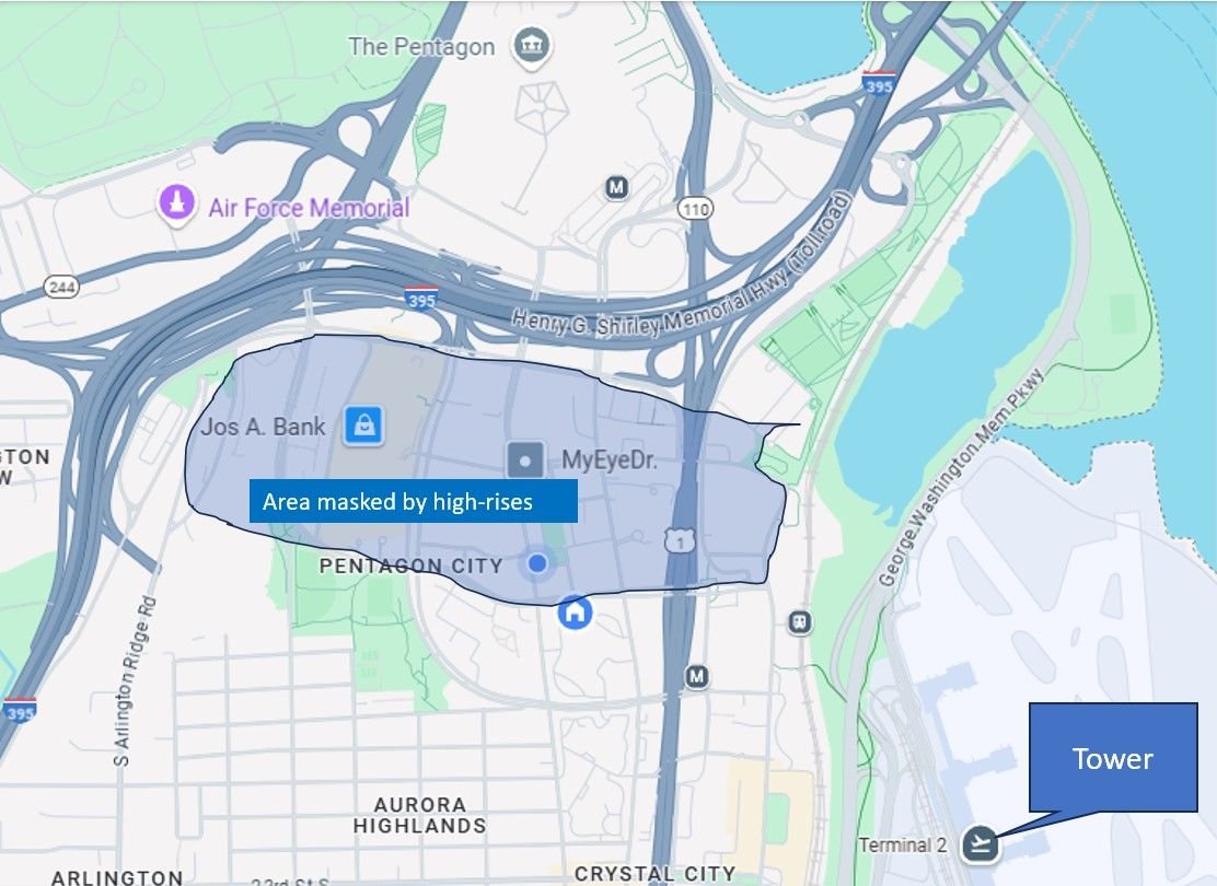
One would definitely hope that traffic is coordinated. From my perspective (17th floor, facing east) the Route 5 traffic is just above the level of the Arlington Ridge treeline as it enters my FOV and is then masked by high-rises as it follows the red line over 395. The terrain and buildings are next to 395 so the 196-foot tower can't see over them. Using GE Pro it looks as if the helos are seconds from the 15 approach before the tower has line of sight to them.
Last edited by LowObservable; 12th March 2025 at 14:07 .
Subjects
DCA
Route 5
VFR
Links are to this post in the relevant subject page so that this post can be seen in context.
Reply to this quoting this original post. You need to be logged in. Not available on closed threads.
March 12, 2025, 18:31:00 GMT
permalink Post: 11846383
Subjects
ATC
Route 5
Links are to this post in the relevant subject page so that this post can be seen in context.
Reply to this quoting this original post. You need to be logged in. Not available on closed threads.
March 12, 2025, 18:48:00 GMT
permalink Post: 11846398
Subjects
ATC
Route 5
Links are to this post in the relevant subject page so that this post can be seen in context.
Reply to this quoting this original post. You need to be logged in. Not available on closed threads.
March 31, 2025, 21:24:00 GMT
permalink Post: 11858201
Subjects
ADSB (All)
Route 5
Links are to this post in the relevant subject page so that this post can be seen in context.
Reply to this quoting this original post. You need to be logged in. Not available on closed threads.
April 25, 2025, 21:45:00 GMT
permalink Post: 11873648
Also, note that it is now clearly marked that the flightpath is to the West of the Pentagon. One wonders what the reviewers thought of the Apocalypse Now hard-banking stunts around the east side of the building under the 15 approach.
Subjects
Route 5
Links are to this post in the relevant subject page so that this post can be seen in context.
Reply to this quoting this original post. You need to be logged in. Not available on closed threads.
April 29, 2025, 15:34:00 GMT
permalink Post: 11875483
If this is about one pilot and one operation, and about a single error 15 seconds before a collision on Route 4, why does Route 5 remain almost completely shut down , and not by the FAA?
I have 100% visual and audible on every Route 5 movement from The Lair, even if I'm not at my desk. Seen two operations since the accident.
I suspect that the answer is this: someone reporting to DoD leadership, not Army aviation, came in, took one look at the ops and ops standards, screamed WHISKEY THE ALFA FOXTROT and observed that it was sheer blind luck the accident hadn't happened earlier, and possibly on the 15 approach with a dozen or so teenage soccer players added to the casualty list.
Last edited by LowObservable; 29th April 2025 at 16:19 .
Subjects
DEI
FAA
Route 4
Route 5
Links are to this post in the relevant subject page so that this post can be seen in context.
Reply to this quoting this original post. You need to be logged in. Not available on closed threads.
April 29, 2025, 17:04:00 GMT
permalink Post: 11875527
If Route 5 is not being used (and Route 4 is shutdown), how are military helicopters accessing JPN?
Prior to the DCA accident, I don\x92t know that I\x92d ever seen a UH-60 out my way on Route 9 in nearly 3 decades. Now PAT UH-60s are almost a daily occurrence on Route 9 (saw/heard 4 yesterday). The ADW-based UH-1Ns are also flying Route 9 more frequently.
I maintain the the DC helicopter routes (including Route 4) interior to the Beltway are not inherently unsafe if used with appropriate restrictions and ATC-applied separation.
Subjects
DCA
FAA
Route 4
Route 5
Route 9
Separation (ALL)
Links are to this post in the relevant subject page so that this post can be seen in context.
Reply to this quoting this original post. You need to be logged in. Not available on closed threads.
May 03, 2025, 04:08:00 GMT
permalink Post: 11877511
DCA LC helicopter and fixed wing positions were combined (Bueller? Bueller?)
PAT23 was a Gold Top (Mike) UH-60
PAT23 was issued two holds along Route 5: (1st) 3 mi W of DCA, and (2nd) at \x93Glebe\x94
LC then cleared PAT23 from \x93Glebe\x94 along Route 5 to the Pentagon
LC made multiple requests to PAT23 to report landing assured. It seemed to take an unusually long time for PAT23 to get to the JPN landing pad. Unclear why PAT23 (and apparently other helicopters) fly counter-clockwise; i.e., continue to follow 395 S of Pentagon (past south parking), then turn N to follow 110 (past the Metro entrance) to the JPN landing pad. Why not use the charted transition route along 27/Washington Blvd?
LC seemed unclear of PAT23\x92s position. At one point directed PAT23 to fly westbound while PAT23 appeared to be landing.
Both DAL1671 and RPA5825 go-arounds were LC directed. No pilot reports of TCAS RA heard. After checking in with departure/approach, PCT didn\x92t request reason for go-around and pilots made no comment about go-around.
Subjects
ADSB (All)
DCA
PAT23
Route 5
TCAS (All)
TCAS RA
Links are to this post in the relevant subject page so that this post can be seen in context.
Reply to this quoting this original post. You need to be logged in. Not available on closed threads.
May 24, 2025, 15:13:00 GMT
permalink Post: 11889642
It would also be good to know who was on board that helicopter and why it was Pete Hairgelseth.
Subjects
DCA
Route 5
Links are to this post in the relevant subject page so that this post can be seen in context.
Reply to this quoting this original post. You need to be logged in. Not available on closed threads.
January 29, 2026, 00:17:00 GMT
permalink Post: 12028883
Subjects
DCA
FAA
Route 5
Links are to this post in the relevant subject page so that this post can be seen in context.
Reply to this quoting this original post. You need to be logged in. Not available on closed threads.