February 06, 2025, 16:55:00 GMT
permalink Post: 11823104
Ref para 3.2.3. e. 2 here https://www.faa.gov/air_traffic/publ...l%20separation .
Subjects
ATC
Separation (ALL)
Traffic in Sight
Visual Separation
Links are to this post in the relevant subject page so that this post can be seen in context.
Reply to this quoting this original post. You need to be logged in. Not available on closed threads.
February 06, 2025, 18:20:00 GMT
permalink Post: 11823141
Ref para 3.2.3. e. 2 here https://www.faa.gov/air_traffic/publ...l%20separation .
I have watched these comments in two threads with interest. Helo routes under busy approach lanes was (and I believe, still is) the norm at Boscombe Down when I arrived there in th eearly 90s. When the civvy incumbants left and the military took over we had to learn from scratch and one of the first things was to sort out the procedure for helicopters routing from Middle Wallop, along the railway line towards Boscombe Down before making a sharp right to go under the approach path to 23 before heading of north west into the Salisbury Plain play areas. As far as I remember this was a no-RT route and was a akin to a child crossing the road (look left, look right and when safe, cross). It was not unusal to have a jet on PAR and then a little blip appear about 2 miles finals crossing at 90 degrees. I seem to think this had been going on like this for years. After that it was mandated that a call to ATC must be made, and if traffic was busy, the helos held clear of the appraoch path. I cannot remember the exact details but think there was a150ft cap as well and a conspicuity squawk. Back then Boscombe was incredibly busy.
IMHO the crew on the helo were alerted to traffic, a misident occurs and they press on, maybe relaxing their altitude accuracy as they are not aware of any other threats besides the one they can see in the distance, which they will clearly pass behind as requested. They would have no clue as to aircraft type.
A very sad incident indeed and my heart goes out to all involved.
Subjects
ATC
Pass Behind
Pass Behind (All)
Separation (ALL)
Traffic in Sight
Links are to this post in the relevant subject page so that this post can be seen in context.
Reply to this quoting this original post. You need to be logged in. Not available on closed threads.
February 06, 2025, 19:52:00 GMT
permalink Post: 11823184
Ref para 3.2.3. e. 2 here https://www.faa.gov/air_traffic/publ...l%20separation .
Subjects
ATC
Separation (ALL)
Traffic in Sight
Visual Separation
Links are to this post in the relevant subject page so that this post can be seen in context.
Reply to this quoting this original post. You need to be logged in. Not available on closed threads.
February 06, 2025, 23:43:00 GMT
permalink Post: 11823316
Last edited by artee; 7th February 2025 at 00:21 . Reason: Changed VFR to Visual Separation.
Subjects
Separation (ALL)
Visual Separation
Links are to this post in the relevant subject page so that this post can be seen in context.
Reply to this quoting this original post. You need to be logged in. Not available on closed threads.
February 07, 2025, 00:03:00 GMT
permalink Post: 11823326
I wouldn't be surprised it's a high percentage of the Heli route1 & 4 traffic that requests "Visual Separation".
Have been listening to a few of LiveATC recordings. On the recording combining TWR & Heli frequencies, you can hear all transmissions (which sometimes overlap), however overall quality is poor. Nevertheless, I get the impression "request Visual Separation" is a common thing.
On the recording of the TWR VHF-frequency only, quality is good, but you don't get the requests/replies from the Heli's, so it's not always clear what was being requested/approved.
Subjects
Separation (ALL)
VFR
Visual Separation
Links are to this post in the relevant subject page so that this post can be seen in context.
Reply to this quoting this original post. You need to be logged in. Not available on closed threads.
February 07, 2025, 00:09:00 GMT
permalink Post: 11823328
Did the FAA or the Army assume they would always be able to apply visual (NOT VFR) separation. Visual separation does not necessarily mean 500\x92 vertically and 1.5 nm or radar target separation; it means \x93I see you, I miss you\x94. Did the operating plan always direct crews to use visual separation as the default plan? I hope not, but it is only I see it being written.
Subjects
FAA
IFR
Radar
Route 4
Separation (ALL)
VFR
Visual Separation
Links are to this post in the relevant subject page so that this post can be seen in context.
Reply to this quoting this original post. You need to be logged in. Not available on closed threads.
February 07, 2025, 02:15:00 GMT
permalink Post: 11823361
You can be VFR in the Class B and treated exactly like an IFR flight. The clearance requirement from clouds VFR is just "clear of" clouds. You can have clouds three inches over you and five inches under you with each wingtip 3 inches away from them and still be VFR. This is much reduced from C, D, and E because you are under positive control. The helo was let loose to provide their own visual separation, which is a totally separate thing.
Subjects
IFR
Separation (ALL)
VFR
Visual Separation
Links are to this post in the relevant subject page so that this post can be seen in context.
Reply to this quoting this original post. You need to be logged in. Not available on closed threads.
February 07, 2025, 03:43:00 GMT
permalink Post: 11823374

The CRJ was given the right of way by ATC, who did not control the conflict. All lateral issues, because the vertical does not matter until more than 500' separation can be maintained. Even at 200', the helo was in the CRJ's airspace in all 4 dimensions.
Subjects
ATC
CRJ
Separation (ALL)
Vertical Separation
Links are to this post in the relevant subject page so that this post can be seen in context.
Reply to this quoting this original post. You need to be logged in. Not available on closed threads.
February 07, 2025, 04:52:00 GMT
permalink Post: 11823390
Seems to me that the collision altitude is reasonably well established.
Further, seems to me that the helicopter was reporting 200 feet via the IFF (transponder), probably from the AAU-32 Baro altimeter instrument in the cockpit.
I now understand that the H-60 had an ADS-B capable black box upgrade in place of the original basic IFF (APX-100?), and that the extended (ADS-) squitter message was turned off on the subject flight.
I think it is worth a close review of the static line plumbing to the AAU-32 which is the source of the 29.92 altitude report.
If, for example, the static line became disconnected, then cockpit ambient pressure might influence (bias) the AAU-32's reading.
I'd check the records to see if a pitot-static leak set had been performed in the recent past, and I'd inspect the remnants of cockpit plumbing if practical
Second... I'd check the upgraded ADS-B capable IFF/Transponder to see if it used aircraft static altitude sensed values as it reported "altitude" , and not (ever) use any other value such as altitude above geoid.
Long-shot thoughts, but perhaps worth considering.
There is graphic evidence that the fuselage of the 60 went under the nose of the CRJ700, and they hit is probably established beyond reasonable doubt on this forum, if not in the evidence of the wreckage in the Potomac. The flight path of the CRJ is well established, up until the moment that the aircraft struck. That should itself have put to bed the matter of height in the analysis.
It is highly probable that the 60 was on altitude on their instruments, and the causal factor being misidentification of a visual target beyond 5nm at night, landing on RWY01, while the CRJ is not pointing at the helicopter, it is presenting the red navlight on the port wingtip to the helicopter drivers, along with occasional strobes against a night sky. The vector of the CRJ across the visual sector of the helo crews was a slow translation to the right, and then from off around 10 o'clock the CRJ intersects the RWY33 finals and becomes a stationary target well off the main scan of the helicopter crew. When asked to confirm they are passing behind the CRJ traffic, they have the RWY01 traffic off to their right, and they are reasonably expecting that to be their traffic. If they don't have a breadcrumb trace of the traffic on their ND of tac display, while the outcome is unfortunate, I would argue that misidentification of a target in a condition where misidentification is a high probability is not the primary causal factor, it is a consequence of the practice of mixing crossing LL traffic with landing and TO traffic.
My concerns are not future risk from this condition occurring, failure to place spak filler over the cracks in this practice would be naughty. My concern is the system scapegoating a US Army flight crew doing a task that is arguably unreasonable. The fact that some may consider it just normal practice done badly does not answer the fact that physiological limitations and the kinetics of this situation make a mid air a near certainty, the obvious evidence being they did hit, the day before there was a near-miss/loss of separation.
It is time for command to assume responsibilities that go with their post, and not blame those beneath them that travel in harms way on the implicit faith that command is competent and cares for the crews safety, and the national resource that they represent. To do otherwise is conduct unbecoming.
The CRJ crew were having a normal day, until they were killed. The passengers on board could also reasonably expect that our industry cares enough to actually do what we say we are doing, and to MANAGE SAFETY , if that is not too much to ask for. Managing safety does not equate to box ticking, it is the very fact we have devolved into considering safety in a stochastic system to be assured by compliance that we get to this sorry saga.
Last edited by fdr; 7th February 2025 at 20:23 .
Subjects
ADSB (All)
Altimeter (All)
CRJ
Separation (ALL)
Links are to this post in the relevant subject page so that this post can be seen in context.
Reply to this quoting this original post. You need to be logged in. Not available on closed threads.
February 07, 2025, 11:55:00 GMT
permalink Post: 11823592
Regarding to the Pavlovian - if PAL25 wouldnt have requested 'visual separation', what "punishment" would they expect from the Tower? Orbit(s)? Vectors? Or somethin wild, considering 200/300' altitude limits along the river and buildings/infrastructure left and right (what diameter would an orbit cost with a Blackhawk, is it feasible over black water at 200')? Therefore I am asking - would a non-request of a 'visual separation' mean major complications to such a helicopter at night? That as well would then be a significant flaw in the design.
Subjects
AA5342
Blackhawk (H-60)
CRJ
New York Times
Separation (ALL)
Visual Separation
Links are to this post in the relevant subject page so that this post can be seen in context.
Reply to this quoting this original post. You need to be logged in. Not available on closed threads.
February 07, 2025, 12:05:00 GMT
permalink Post: 11823605
Regarding to the Pavlovian - if PAL25 wouldnt have requested 'visual separation', what "punishment" would they expect from the Tower? Orbit(s)? Vectors? Or somethin wild, considering 200/300' altitude limits along the river and buildings/infrastructure left and right (what diameter would an orbit cost with a Blackhawk, is it feasible over black water at 200')? Therefore I am asking - would a non-request of a 'visual separation' mean major complications to such a helicopter at night? That as well would then be a significant flaw in the design.
Waiting for the tower to have no aircraft below ~700ft in the approach area, if we're assuming a 1.5Nm separation, could be quite a while.
Subjects
AA5342
Blackhawk (H-60)
CRJ
Separation (ALL)
VFR
Visual Separation
Links are to this post in the relevant subject page so that this post can be seen in context.
Reply to this quoting this original post. You need to be logged in. Not available on closed threads.
February 07, 2025, 12:37:00 GMT
permalink Post: 11823616
1.5NM is obviously not applied, look at the south flow arrivals TCAS RA the day prior. It, a PAT merged previously with a SWA 737 at TCAS TA altitudes with Collision Alert to ATC radar, before causing the later RA.
Last edited by moosepileit; 7th February 2025 at 15:53 .
Subjects
ATC
Radar
Separation (ALL)
TCAS (All)
TCAS RA
Links are to this post in the relevant subject page so that this post can be seen in context.
Reply to this quoting this original post. You need to be logged in. Not available on closed threads.
February 07, 2025, 13:24:00 GMT
permalink Post: 11823651
How? considering where they have been at the first briefing about the conflict, just about entering Washington Channel ?
I have learned here:
speed around 90kt min, when orbiting
hovering not a safe option at night over black water (despite lights left and right and everywhere else)
Washington Channel: 200 yards wide
plus golf course and Potomac: less 1 mile wide
runway ends 01 and 15
city to the left with stadions etc.
I really run out of an idea what ATC would clear if the PAT25 crew didnt ask for "visual separation"...
Last edited by 51bravo; 7th February 2025 at 13:42 .
Subjects
ATC
PAT25
Separation (ALL)
Visual Separation
Links are to this post in the relevant subject page so that this post can be seen in context.
Reply to this quoting this original post. You need to be logged in. Not available on closed threads.
February 07, 2025, 14:19:00 GMT
permalink Post: 11823680
There is also route RT6 from Bolling to Woods Corner, but I don't think that the steep climb from Hains Point 200ft to Bolling 1400ft is reasonable.
Subjects
ATC
PAT25
Separation (ALL)
Visual Separation
Links are to this post in the relevant subject page so that this post can be seen in context.
Reply to this quoting this original post. You need to be logged in. Not available on closed threads.
February 07, 2025, 14:59:00 GMT
permalink Post: 11823702
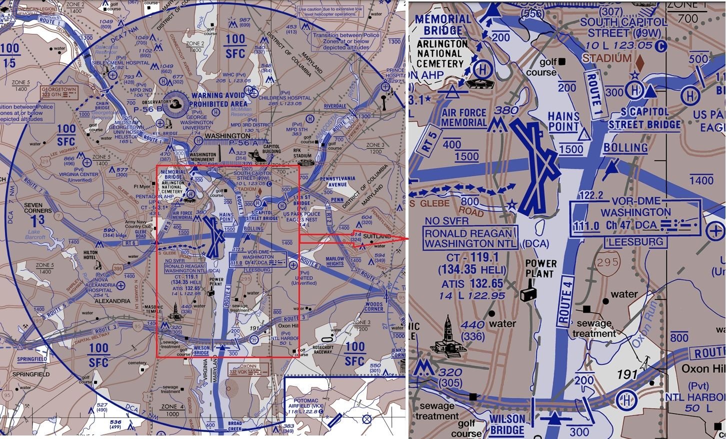
Anything approaching Rwy 1 should be below ~700ft anywhere north of the sewage treatment marker; use the Wilson Bridge for a bit of headroom because not all aircraft are going to be perfectly on glideslope.
The river is far narrower than 1.5Nm so clearly a southbound helicopter on Route 4 can never cross a northbound aircraft approaching runway 1 north of the Wilson Bridge.
You'd have to hold a southbound helicopter north of either the Memorial or Capitol St Bridges until previous traffic had landed. Then have a sufficiently large gap with no arrivals (or departures until south of the runways) for the helicopter to reach the Wilson St Bridge before the next arrival crosses that bridge.
That's the preceding aircraft covering ~3Nm at 140kt (~80s), followed by the helicopter covering ~6Nm at ~100kt (another 3.5min), and accurately timing the next arrival so it doesn't cross the Wilson bridge until after the helicopter, or it needs to do a go-around.
Subjects
Route 4
Route 5
Separation (ALL)
Links are to this post in the relevant subject page so that this post can be seen in context.
Reply to this quoting this original post. You need to be logged in. Not available on closed threads.
February 07, 2025, 15:40:00 GMT
permalink Post: 11823717
OTOH, the CRJ is not flying a BARO ALT, it is descending on a visual glide slope that would approximate something near 3 degree, 5.2%, from whatever aiming point they had chosen, +/- the vertical error from that ideal glide slope. They stuck each other with the UH60 striking from below. John D and LW50 can suggest the static system error that is in the -1 for the UH60L, I don't have the FM for that type. The static pressure ports are on the 2 pitot static heads that are above the cockpit area, just behind the rear edge on the pilots doors. For the UH60A,
...so for the A model, the drivers get raw static for their ALT displays. Later models with EFIS systems would take the same data and process that from analog to digital, and that would normally be done by an ADC system, which can remove the errors that arise from direct static sources with some rat cunning. For our jets, the ADC data does not correct all static errors, that is why we generally see a negative transient of altitude and VS rate at rotate, the flow conditions around the static ports are changing. The helicopter has the static ports in the wake of the rotor, which alters with CT, and with J so pretty much is a mess for getting nice n' tidy accurate pressure altitude displayed. The RADALT is better, it is subject to errors as well due to attitude changes but they are generally tolerable by the choice of the fan shape of the transmitter. Bottom line is, assuming that the aircraft should have missed by a hair vertically given the wide range of errors that would apply to the helicopter instruments is immaterial to the fact that they were otherwise going to be in a grossly unacceptable vertical separation in any circumstance. That they arrived at the same place in space and time is a consequence of a very straight forward error of identification of a single target when confronted with multiple targets, which we have known to be an issue for about a century. Hard to blame the PF in getting caught out doing a practice that is known to be hazardous but which is institutionally tolerated as "business as usual".
Last edited by fdr; 7th February 2025 at 15:55 .
Subjects
CRJ
Radio Altimeter
Separation (ALL)
Vertical Separation
Links are to this post in the relevant subject page so that this post can be seen in context.
Reply to this quoting this original post. You need to be logged in. Not available on closed threads.
February 07, 2025, 15:59:00 GMT
permalink Post: 11823731
Anything approaching Rwy 1 should be below ~700ft anywhere north of the sewage treatment marker; use the Wilson Bridge for a bit of headroom because not all aircraft are going to be perfectly on glideslope.
The river is far narrower than 1.5Nm so clearly a southbound helicopter on Route 4 can never cross a northbound aircraft approaching runway 1 north of the Wilson Bridge.
You'd have to hold a southbound helicopter north of either the Memorial or Capitol St Bridges until previous traffic had landed. Then have a sufficiently large gap with no arrivals (or departures until south of the runways) for the helicopter to reach the Wilson St Bridge before the next arrival crosses that bridge.
That's the preceding aircraft covering ~3Nm at 140kt (~80s), followed by the helicopter covering ~6Nm at ~100kt (another 3.5min), and accurately timing the next arrival so it doesn't cross the Wilson bridge until after the helicopter, or it needs to do a go-around.
Hence the issue requiring metering the helicopters on the numbered Routes.
I don't suggest a hard 1.5NM, but anywhere standard fixed wing ops cannot assure 500' vertical separation, Rotary wing traffic must be gated and controlled.
If rotary wing mission dictates, then fixed wing traffic will have to wait/go missed/discontinue approach. Visual Sep, ATC and a Pavlovian environment killed an airliner.
Subjects
ATC
Route 4
Route 5
Separation (ALL)
Vertical Separation
Links are to this post in the relevant subject page so that this post can be seen in context.
Reply to this quoting this original post. You need to be logged in. Not available on closed threads.
February 07, 2025, 17:07:00 GMT
permalink Post: 11823784
I don't suggest a hard 1.5NM, but anywhere standard fixed wing ops cannot assure 500' vertical separation, Rotary wing traffic must be gated and controlled.
If rotary wing mission dictates, then fixed wing traffic will have to wait/go missed/discontinue approach. Visual Sep, ATC and a Pavlovian environment killed an airliner.
I'm still going to argue that a helicopter on Route 4 from DCA to the Wilson Bridge or across Route 6 is unacceptable while there's an approaching aircraft below 700ft.
Subjects
ATC
DCA
Route 4
Separation (ALL)
Vertical Separation
Links are to this post in the relevant subject page so that this post can be seen in context.
Reply to this quoting this original post. You need to be logged in. Not available on closed threads.
February 07, 2025, 18:15:00 GMT
permalink Post: 11823828
This page, section "Separation minima based on ATS surveillance systems" quotes ICAO as saying that even in terminal space with good radar, separation should not go below 1,000ft vertically or 3Nm (2.5Nm if established on the same final approach in sequence within 10Nm of the runway). We're already blithely discussing half those standards as being impossible to meet.
Subjects
ADSB (All)
ICAO
Radar
Separation (ALL)
Links are to this post in the relevant subject page so that this post can be seen in context.
Reply to this quoting this original post. You need to be logged in. Not available on closed threads.
February 07, 2025, 18:22:00 GMT
permalink Post: 11823829
This page, section "Separation minima based on ATS surveillance systems" quotes ICAO as saying that even in terminal space with good radar, separation should not go below 1,000ft vertically or 3Nm (2.5Nm if established on the same final approach in sequence within 10Nm of the runway). We're already blithely discussing half those standards as being impossible to meet.
Subjects
ADSB (All)
ICAO
Radar
Separation (ALL)
Vertical Separation
Links are to this post in the relevant subject page so that this post can be seen in context.
Reply to this quoting this original post. You need to be logged in. Not available on closed threads.