February 01, 2025, 21:52:00 GMT
permalink Post: 11819330
From the 'Mil' thread:
Subjects
ADSB (All)
CRJ
TCAS (All)
TCAS RA
Links are to this post in the relevant subject page so that this post can be seen in context.
Reply to this quoting this original post. You need to be logged in. Not available on closed threads.
February 02, 2025, 01:39:00 GMT
permalink Post: 11819437
Subjects
ATC
Links are to this post in the relevant subject page so that this post can be seen in context.
Reply to this quoting this original post. You need to be logged in. Not available on closed threads.
February 02, 2025, 21:47:00 GMT
permalink Post: 11820136
from https://asn.flightsafety.org/wikibase/474365
KDCA 300052Z 29015G25KT 10SM CLR 11/M07 A2987 RMK AO2 SLP114 T01061072
Subjects
KDCA
Links are to this post in the relevant subject page so that this post can be seen in context.
Reply to this quoting this original post. You need to be logged in. Not available on closed threads.
February 03, 2025, 22:46:00 GMT
permalink Post: 11820975
No crossing of 'Route 4' prior to ...
Subjects
CRJ
Circle to Land (Deviate to RWY 33)
Pass Behind
Pass Behind (All)
Route 4
Links are to this post in the relevant subject page so that this post can be seen in context.
Reply to this quoting this original post. You need to be logged in. Not available on closed threads.
February 03, 2025, 22:57:00 GMT
permalink Post: 11820985
Last edited by Senior Pilot; 4th February 2025 at 04:18 . Reason: Remove thread drift
Subjects: None
No recorded likes for this post (could be before pprune supported 'likes').Reply to this quoting this original post. You need to be logged in. Not available on closed threads.
February 03, 2025, 23:26:00 GMT
permalink Post: 11821010
Thanks
Subjects
ATC
Blackhawk (H-60)
IFR
Radar
VFR
Links are to this post in the relevant subject page so that this post can be seen in context.
Reply to this quoting this original post. You need to be logged in. Not available on closed threads.
February 03, 2025, 23:29:00 GMT
permalink Post: 11821012
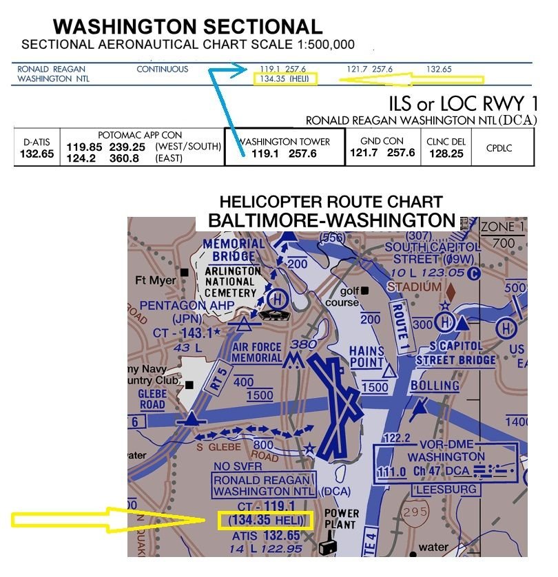
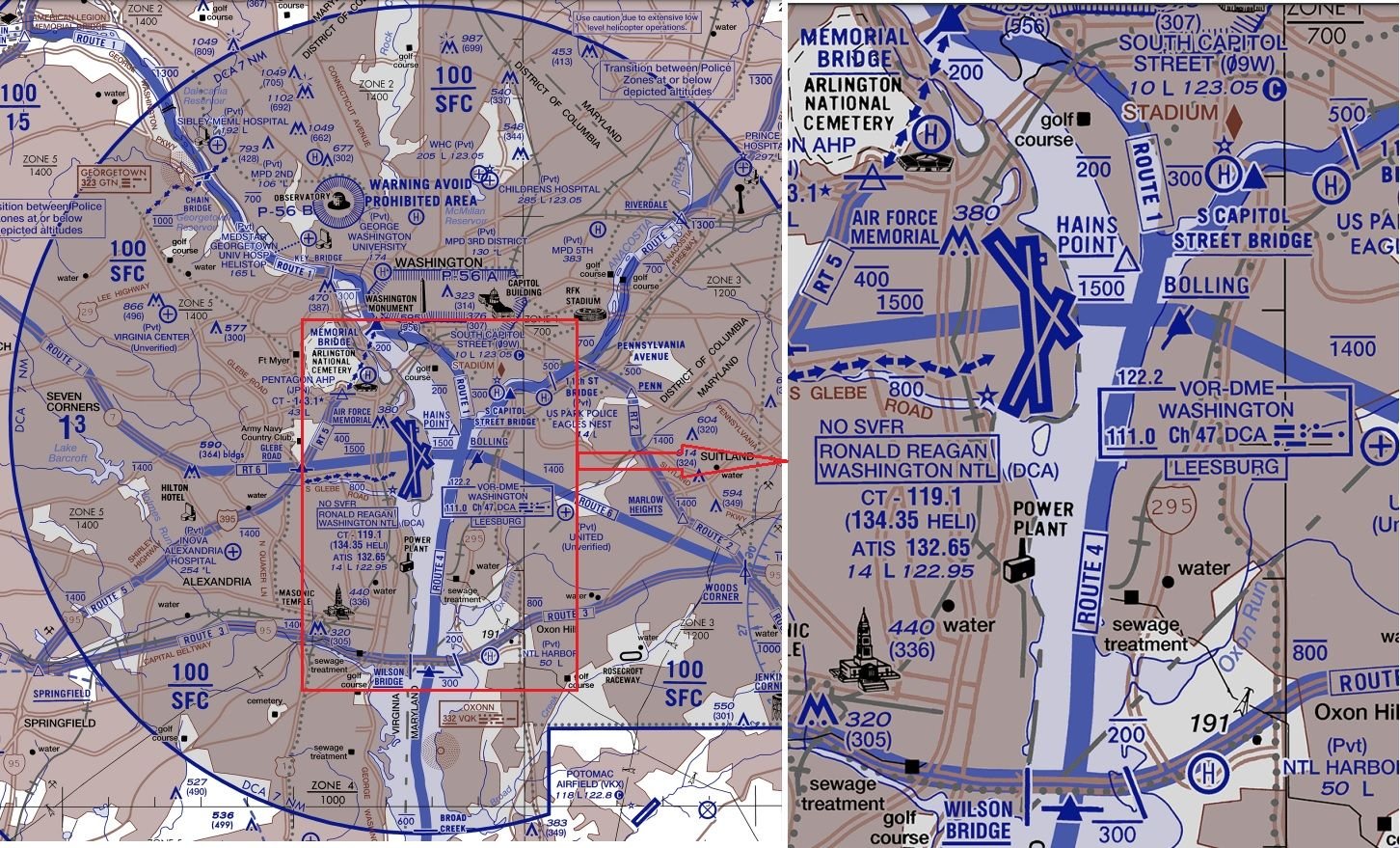
But for those rebuking any mentioning of a VHF Heli frequency, please provide some proof as any reference I find on VFR sectionals, is a VHF Heli-frequency.
IFR charts only have the regular VHF+UHF TWR freq.
Subjects
IFR
VFR
Links are to this post in the relevant subject page so that this post can be seen in context.
Reply to this quoting this original post. You need to be logged in. Not available on closed threads.
February 04, 2025, 00:35:00 GMT
permalink Post: 11821049
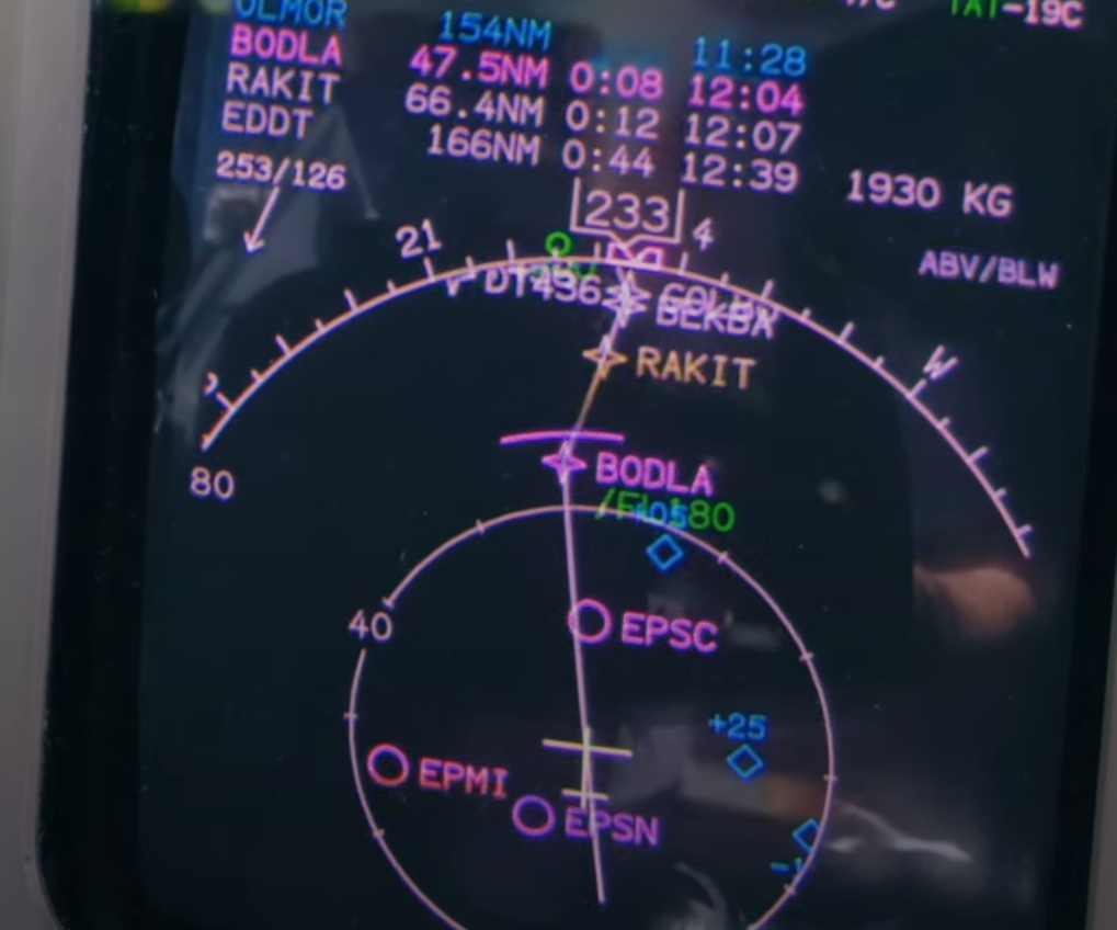
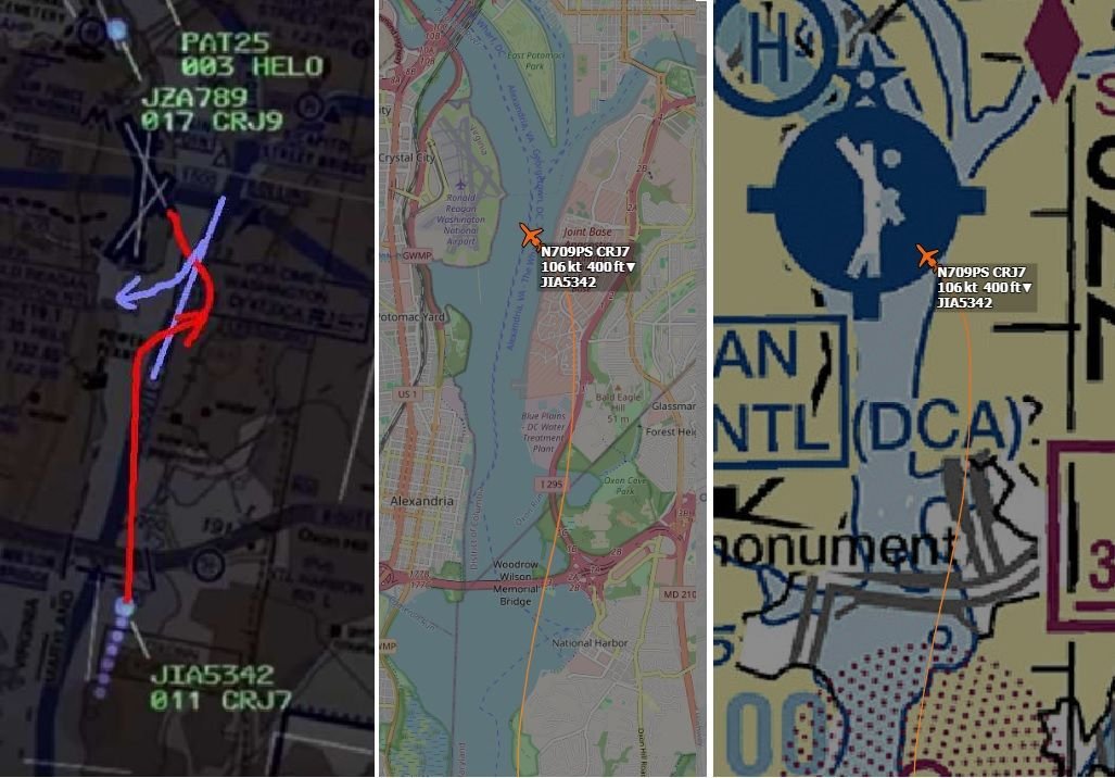
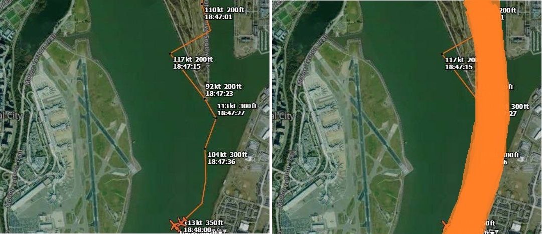
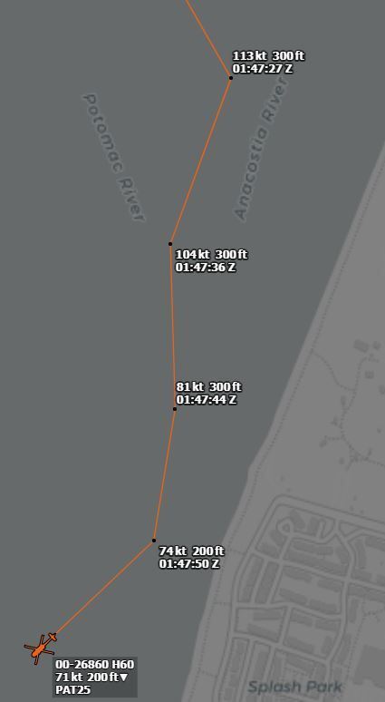
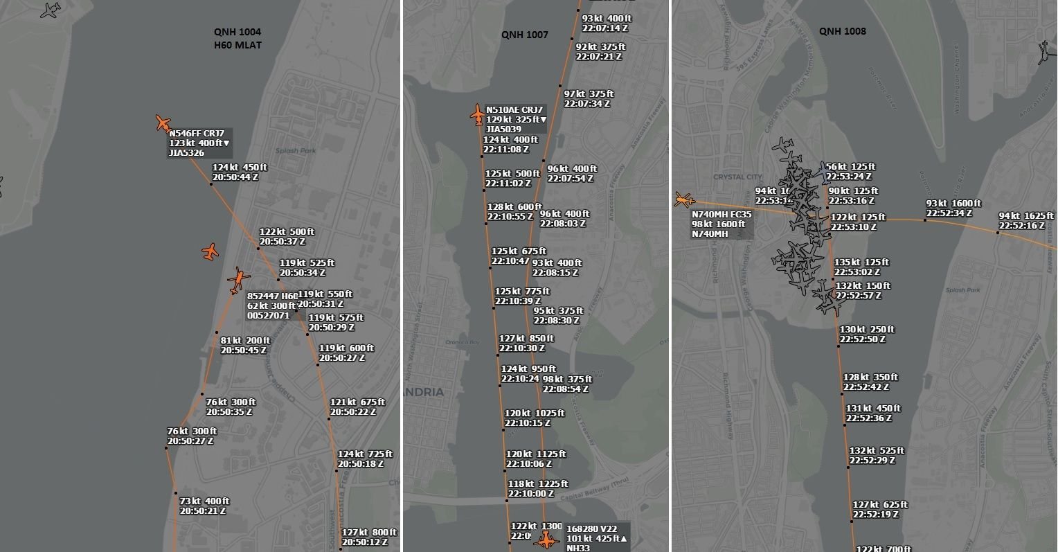
And the "amateur MLAT" tracking of the helo, is only a rough indication of the trajectory with a wide margin of position error and should be interpreted more like the right side hereunder:
Subjects
CRJ
KDCA
Radar
Route 4
Links are to this post in the relevant subject page so that this post can be seen in context.
Reply to this quoting this original post. You need to be logged in. Not available on closed threads.
February 04, 2025, 00:46:00 GMT
permalink Post: 11821058
Subjects
Situational Awareness
Links are to this post in the relevant subject page so that this post can be seen in context.
Reply to this quoting this original post. You need to be logged in. Not available on closed threads.
February 04, 2025, 21:40:00 GMT
permalink Post: 11821727
Subjects: None
No recorded likes for this post (could be before pprune supported 'likes').Reply to this quoting this original post. You need to be logged in. Not available on closed threads.
February 04, 2025, 22:48:00 GMT
permalink Post: 11821767
to put "all the way" into context, 18 seconds is what they had
Subjects
ADSB (All)
NTSB
TCAS (All)
Links are to this post in the relevant subject page so that this post can be seen in context.
Reply to this quoting this original post. You need to be logged in. Not available on closed threads.
February 05, 2025, 00:05:00 GMT
permalink Post: 11821822
I think the confusion comes from the "amateur MLAT" tracking, which calculates the GS based on the multilaterated position calculations, which have a (relatively) large margin of error:
And probably PAT25 was doing initially something in the region of 100kts GS (edit: averaging all but last calculated GS, gives 105kts as average - and over more datapoints, longer trajectory, calculated average GS becomes more reliable)
but at the end it seems there might possibly have been a decreasing GS trend:
Last edited by DIBO; 5th February 2025 at 00:10 . Reason: added calculated average GS
Subjects
ADSB (All)
CRJ
PAT25
Radar
Links are to this post in the relevant subject page so that this post can be seen in context.
Reply to this quoting this original post. You need to be logged in. Not available on closed threads.
February 07, 2025, 00:03:00 GMT
permalink Post: 11823326
I wouldn't be surprised it's a high percentage of the Heli route1 & 4 traffic that requests "Visual Separation".
Have been listening to a few of LiveATC recordings. On the recording combining TWR & Heli frequencies, you can hear all transmissions (which sometimes overlap), however overall quality is poor. Nevertheless, I get the impression "request Visual Separation" is a common thing.
On the recording of the TWR VHF-frequency only, quality is good, but you don't get the requests/replies from the Heli's, so it's not always clear what was being requested/approved.
Subjects
Separation (ALL)
VFR
Visual Separation
Links are to this post in the relevant subject page so that this post can be seen in context.
Reply to this quoting this original post. You need to be logged in. Not available on closed threads.
February 07, 2025, 22:21:00 GMT
permalink Post: 11823972
Subjects: None
No recorded likes for this post (could be before pprune supported 'likes').Reply to this quoting this original post. You need to be logged in. Not available on closed threads.
February 10, 2025, 17:56:00 GMT
permalink Post: 11825641
Subjects: None
No recorded likes for this post (could be before pprune supported 'likes').Reply to this quoting this original post. You need to be logged in. Not available on closed threads.
February 10, 2025, 21:47:00 GMT
permalink Post: 11825733
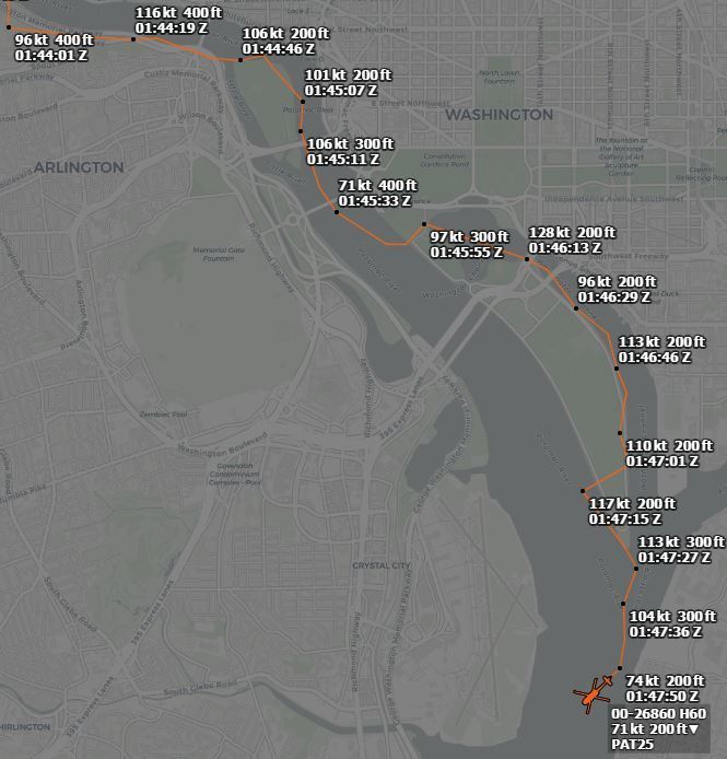
For the first NYT simulated helicopter view, there was (is) no reliable/precise tack info publicly available, the MLAT track that has been overly (ab)used, is a very rough indication only. And the planned Route1->4 transition trajectory is a curved one, anyway.
But it was a good attempt to provide a visualization of what the UH60 pilots were (most likely) confronted with, and a very good attempt at countering public reactions as " how can you miss a landing airliner on a clear night "
Subjects
New York Times
Links are to this post in the relevant subject page so that this post can be seen in context.
Reply to this quoting this original post. You need to be logged in. Not available on closed threads.
February 11, 2025, 00:58:00 GMT
permalink Post: 11825797
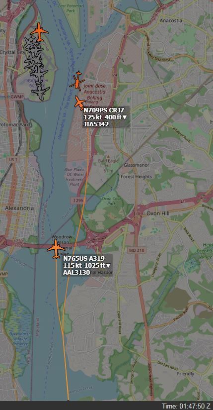
For the ATCO, there wasn't only the flow of arrivals, but a good number of (no delay) departures, all this on intersecting runways and, not shown on the screenshot, in the seconds (a few dozens of...) prior to the accident, the ATCO was handling at least 3 helicopters (Mussel7 / Medevac / PAT25), even not counting the police helicopter working in the SW corner as depicted in the screenshot.
And all this on three* separate frequencies, not fully cross coupled, so TWR was receiving on several occasions, simultaneous/parallel incoming R/T calls (* based on info from other posters in both threads here on pprune & NTSB info - but I still have doubts PAT25 was on UHF, although 3 or 2 freq's, doesn't really matter in this accident's context)
And simulations by VASAviation and the likes, are heavily edited (as they correctly indicate in their comments), so they easily give the impression that traffic and R/T comm's were relatively light...
Subjects
ATCO
NTSB
PAT25
Links are to this post in the relevant subject page so that this post can be seen in context.
Reply to this quoting this original post. You need to be logged in. Not available on closed threads.
February 11, 2025, 13:27:00 GMT
permalink Post: 11826087
Subjects
Separation (ALL)
Vertical Separation
Visual Separation
Links are to this post in the relevant subject page so that this post can be seen in context.
Reply to this quoting this original post. You need to be logged in. Not available on closed threads.
February 14, 2025, 21:03:00 GMT
permalink Post: 11828208

For a couple of days now, was thinking about posting something on an "extra noise" I keep hearing in the R/T comms, when TWR gives the ' pass behind ' instruction. Was wondering whether TWR's Tx wasn't stepped over by someone.
My first impression was that the extra noise came from an radio call from a turbine helicopter (given the typical background noise often heard in radio calls from turbine helicopters). And was wondering if it wasn't PAT25 that started replying to TWR's first ' in sight? ' call, effectively blocking part of TWR's second call, the ' pass behind ' part of the instruction.
In attached mp3 (in .zip per forum attachment requirements) around 00:05 I hear this 'extra noise'.
Edit:
well, this seems to confirm my initial impression:
Last edited by DIBO; 14th February 2025 at 21:07 . Reason: last posts with NTSB info seem to confirm my suspicion
Subjects
ATC
Altimeter (All)
Blackhawk (H-60)
CRJ
CVR
NTSB
PAT25
Pass Behind
Pass Behind (All)
Links are to this post in the relevant subject page so that this post can be seen in context.
Reply to this quoting this original post. You need to be logged in. Not available on closed threads.
February 14, 2025, 22:35:00 GMT
permalink Post: 11828263
In the following decades, I've been more than once frustrated with hundreds of 'stupid' stepping-over's, causing so much confusion (luckily nothing more serious that I witnessed), which all could have been prevented if that mechanism would have been standardized.
Subjects
ICAO
Links are to this post in the relevant subject page so that this post can be seen in context.
Reply to this quoting this original post. You need to be logged in. Not available on closed threads.