February 14, 2025, 23:10:00 GMT
permalink Post: 11828287
...
15:04 parameter is not the primary means the
15:07 pilots would have used to determine
15:08 their height during flight the pilots
15:10 are not typically navigating using radio
15:13 altitude it is often different from what
15:15 they see on their primary Al altimeters
15:18 the next term is barometric altitude
15:21 this is typically the altitude the
15:23 pilots would use while they were flying
Subjects
NTSB
PAT25
Radio Altimeter
Links are to this post in the relevant subject page so that this post can be seen in context.
Reply to this quoting this original post. You need to be logged in. Not available on closed threads.
February 14, 2025, 23:17:00 GMT
permalink Post: 11828288

And before people start jumping all over this 'feature', yes, yes, indeed an extra 'button' needs to be provided on the radio, to knowingly override the 'Tx Inhibit' feature in case of stuck mic., etc.
Subjects: None
No recorded likes for this post (could be before pprune supported 'likes').Reply to this quoting this original post. You need to be logged in. Not available on closed threads.
February 15, 2025, 00:52:00 GMT
permalink Post: 11828325
Subjects
ATC
QNH
Radio Altimeter
Links are to this post in the relevant subject page so that this post can be seen in context.
Reply to this quoting this original post. You need to be logged in. Not available on closed threads.
February 15, 2025, 00:56:00 GMT
permalink Post: 11828328
Subjects
NTSB
Night Vision Goggles (NVG)
Links are to this post in the relevant subject page so that this post can be seen in context.
Reply to this quoting this original post. You need to be logged in. Not available on closed threads.
February 15, 2025, 02:20:00 GMT
permalink Post: 11828339
Vertical and routing wise, the description is pretty detailed.
Personally I think these discussions on the lateral width, or the exact position of the route isn't really relevant. Abeam KDCA for example, I expect not exactly hugging the river bank, but remaining well within the eastern half of the river, wouldn't cause any 'pilot deviation'.
Subjects
KDCA
Links are to this post in the relevant subject page so that this post can be seen in context.
Reply to this quoting this original post. You need to be logged in. Not available on closed threads.
February 19, 2025, 23:29:00 GMT
permalink Post: 11831848

Subjects
QNH
Links are to this post in the relevant subject page so that this post can be seen in context.
Reply to this quoting this original post. You need to be logged in. Not available on closed threads.
February 27, 2025, 21:56:00 GMT
permalink Post: 11837401
On thing that was strikingly absent in the interview, was an in-depth discussion on the use (or might I say abuse) of the " request visual separation ". This aspect is crucial in this accident, but I have a hunch that this topic is too sensitive to be commented on by a former colleague....
Subjects
Separation (ALL)
Visual Separation
Links are to this post in the relevant subject page so that this post can be seen in context.
Reply to this quoting this original post. You need to be logged in. Not available on closed threads.
August 01, 2025, 22:40:00 GMT
permalink Post: 11932083
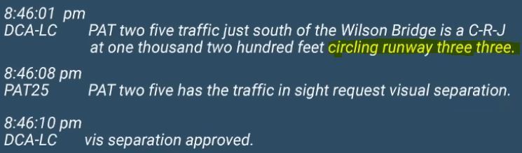
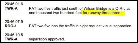
And they acknowledged it, although in a very short reply (understandable to keep R/T's as short as possible).
But replying with " traffic circling 33 in sight " just might have improved their own SA, helping to build the mental picture that mentioned traffic was going to move slightly to their left and was at some point going to cross their route from left to right. And if they didn't have that mental picture of what "circling 33" meant for their routing, then a lot was wrong long before the impact.
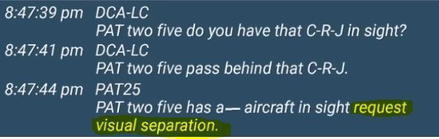
And what strikes me over and over again, is this mutual 'pavlovian' "request visual separation"-"approved" thing, as if proclaiming these words, absolves all involved from any rules/restriction that might hinder the smooth flow of things (which it does - kind of).
Even at the last chance of averting disaster by the controller (by clearly indicating the target), the pavlovian reaction was there again (totally meaningless as it was already requested and approved 96 second earlier)...

Last edited by DIBO; 2nd August 2025 at 22:03 . Reason: add extract from UH60 CVR transcript (not available/included in NTSB debrief animation)
Subjects
ATC
CVR
Night Vision Goggles (NVG)
Separation (ALL)
Situational Awareness
Visual Separation
Links are to this post in the relevant subject page so that this post can be seen in context.
Reply to this quoting this original post. You need to be logged in. Not available on closed threads.
August 08, 2025, 00:17:00 GMT
permalink Post: 11934969
That's why I don't understand all the fuzz about ADS-B in the UH60. TCAS in the CRJ worked as designed, including RA inhibit down low.
I've wondered a couple of times, what if.... the CRJ crew had failed to spot the UH60 all together. Now a left-banking evasive manoeuver was started, and only the left wing was substantially shredded by the rotor.
If they would has kept wings level, maybe both wings would have narrowly escaped major damage, only MLG and belly at risk of the main rotor.
But it all doesn't matter, really. 'Fate is the hunter' and they got caught.
Subjects
ADSB (All)
ADSB In
CRJ
NTSB Docket
TCAS (All)
Links are to this post in the relevant subject page so that this post can be seen in context.
Reply to this quoting this original post. You need to be logged in. Not available on closed threads.
August 11, 2025, 23:34:00 GMT
permalink Post: 11936975
I wonder how many pilots on rwy 01/19 really perceived this section of the routing as unsafe (when flown correctly = hugging the shoreline at max 200ft).
A nuisance, undoubtedly. And the whole helicopter traffic surrounding DCA, pretty unsafe, I can understand.
And then we have nighttime...
A helicopter may be operated at less than the minimums prescribed in paragraph (b) or (c) of this section, provided each person operating the helicopter complies with any routes or altitudes specifically prescribed for helicopters by the FAA
Subjects
DCA
FAA
Route 4
Links are to this post in the relevant subject page so that this post can be seen in context.
Reply to this quoting this original post. You need to be logged in. Not available on closed threads.
August 11, 2025, 23:49:00 GMT
permalink Post: 11936982
Subjects: None
No recorded likes for this post (could be before pprune supported 'likes').Reply to this quoting this original post. You need to be logged in. Not available on closed threads.