February 16, 2025, 22:52:00 GMT
permalink Post: 11829513
Is the construction and operation of the airspace around DCA a matter of policy judgment? I can almost hear the lawyers planning to file suit arguing that airspace rules which make simple, obvious sense are not derived from policy judgments. I can almost hear them issuing subpoenas (through the necessary international process) of Network Manager or MUAC senior managers to gain testimony that in European airspace, as others have observed about Heathrow, the airspace rules are more like "plug-and-chug" than the sometimes esoteric, and usually vague and/or ambiguous, factors which inform the choices made in - offensive phrase coming - "the policy world."
If we took the FAA to be undertaking "plug and chug" regulatory and procedural activities, unburdened by political considerations and at risk of having EASA or UK CAA regulations and procedures held up as comparators in negligence cases against it, then I think it is highly unlikely that FAA regulations would be as permissive as they are in respect of visual separation and runway occupancy (the two most obvious and frequently cited points of difference, at least where airline operations are concerned), or that DCA\x92s helicopter routes would have existed. So why such a difference in approach? Economic factors are usually held up as the reason, and I fear this takes us away from "plug and chug" regulation into policy territory where immunity would seemingly apply.
I very much doubt that any politician, corporate lobbyist or general would explicitly advance the argument that occasional accidents are a tolerable price for the traffic capacity enhancements enabled by visual separation. It'll be interesting to see whether the NTSB forces that argument into the open, or enables it to be avoided by distracting itself with altimetry and other such matters.
Last edited by Easy Street; 16th February 2025 at 23:35 .
Subjects
DCA
FAA
NTSB
Separation (ALL)
Visual Separation
Links are to this post in the relevant subject page so that this post can be seen in context.
Reply to this quoting this original post. You need to be logged in. Not available on closed threads.
February 16, 2025, 23:09:00 GMT
permalink Post: 11829529
He doesn't know his mental model is dead wrong because he latched onto the wrong aircraft in the cluster of 4 visible when the traffic was called to him a couple of minutes ago.
Last edited by Easy Street; 16th February 2025 at 23:38 .
Subjects
CRJ
Night Vision Goggles (NVG)
Links are to this post in the relevant subject page so that this post can be seen in context.
Reply to this quoting this original post. You need to be logged in. Not available on closed threads.
February 19, 2025, 22:35:00 GMT
permalink Post: 11831807
(I've assumed that the altitude is recorded in the closest bin to the actual value. If that's not the case then the error bars would be 25 feet in one direction or the other depending on whether it rounds up or down. An ADSB geek would know. I am also itching to know whether the origin point of your glidepath lines has been adjusted to the same EGM96 height datum as the ADSB values...)
Subjects
ADSB (All)
Links are to this post in the relevant subject page so that this post can be seen in context.
Reply to this quoting this original post. You need to be logged in. Not available on closed threads.
February 21, 2025, 01:51:00 GMT
permalink Post: 11832665
Also, I suspect the military requirement for the routes means they have to be as weather-proof as possible, meaning as low as possible. The route heights are given as maximum heights to be flown when the ceiling permits, and can be underflown when required for weather unless stated.
Subjects
Separation (ALL)
Vertical Separation
Links are to this post in the relevant subject page so that this post can be seen in context.
Reply to this quoting this original post. You need to be logged in. Not available on closed threads.
February 22, 2025, 11:12:00 GMT
permalink Post: 11833584
However, from a US point of view, this is arguably the solution which was in place on the night. It's just that the means of actively keeping the traffic apart, ie visual separation, failed. I am prepared to accept that FAA-style "visual separation" is slightly more robust than "see and avoid" in that it requires ATC to confirm that the pilot has the specific traffic in sight before relaxing separation minima, but the question for the FAA is whether "slightly more robust" is good enough when airliners are involved, particularly at night given the increased potential for misidentification.
I am not sure the subsequent line of discussion over how Class B requires ATC (not pilots) to separate all traffic is a very productive one. Any separation instruction given by ATC relies upon the pilot executing it, for instance by maintaining the cleared altitude. Here, it relied on the pilot not colliding with the specific traffic he had confirmed visual contact with. So far as the FAA is concerned, that's a sufficient degree of control and differs from the "see and avoid" principle applicable to VFR/VFR in Class C, and VFR/Any in Class D. Again, the question is whether that's appropriate.
That last point gives me an opportunity to make an observation I've been pondering for a while. Many European airport control zones are Class D, where on a strict reading of ICAO, VFR traffic is not required to be separated from IFR. But how many of us know a Class D zone where the controller gives traffic information and lets VFR traffic merge with IFR under see and avoid? In practice, European and especially UK ATC exercise a greater degree of control than is strictly required by the ICAO classification. At least in my experience, US airspace is operated closer to ICAO specifications ("visual separation" nothwithstanding).
Last edited by Easy Street; 22nd February 2025 at 11:31 .
Subjects
ATC
DCA
FAA
ICAO
IFR
See and Avoid
Separation (ALL)
Traffic in Sight
VFR
Visual Separation
Links are to this post in the relevant subject page so that this post can be seen in context.
Reply to this quoting this original post. You need to be logged in. Not available on closed threads.
February 22, 2025, 11:57:00 GMT
permalink Post: 11833610
Subjects
ATC
FAA
Separation (ALL)
Visual Separation
Links are to this post in the relevant subject page so that this post can be seen in context.
Reply to this quoting this original post. You need to be logged in. Not available on closed threads.
February 22, 2025, 18:56:00 GMT
permalink Post: 11833817
When genuine "see and avoid" applies (Class C VFR/VFR, Class D VFR/Any) the controller does not need to confirm that VFR pilots have visual contact before allowing separation to reduce, because there *are no* separation minima. At least, not according to ICAO.
As I mentioned earlier, European and especially UK ATC tends to apply more stringent separation than ICAO requires. The 'ATC duty of care' argument in the UK results in its Class D being operated in a similar way to US Class B, in my experience.
Last edited by Easy Street; 22nd February 2025 at 19:10 .
Subjects
ATC
FAA
ICAO
See and Avoid
Separation (ALL)
Traffic in Sight
VFR
Visual Separation
Links are to this post in the relevant subject page so that this post can be seen in context.
Reply to this quoting this original post. You need to be logged in. Not available on closed threads.
February 23, 2025, 12:09:00 GMT
permalink Post: 11834211
If everybody denied visual contact with the other traffic in IFR conditions then ATC will be really pissed, but will have to provide you separation. Isn't that still the case? You can never be completely sure that what you can actually see is the traffic ATC want you to see.

Lufty at SFO
ATC will still have to provide you with separation, yes. But some US airports have too much traffic to operate without pilots accepting visual separation, so you may have to land elsewhere. Hence the discussion upthread about the inseparability of regulation from policy, economics and (ultimately) politics.
Post #10 on that thread...


Subjects
ATC
IFR
Separation (ALL)
Visual Separation
Links are to this post in the relevant subject page so that this post can be seen in context.
Reply to this quoting this original post. You need to be logged in. Not available on closed threads.
March 08, 2025, 09:24:00 GMT
permalink Post: 11843284
Subjects: None
No recorded likes for this post (could be before pprune supported 'likes').Reply to this quoting this original post. You need to be logged in. Not available on closed threads.
March 08, 2025, 21:18:00 GMT
permalink Post: 11843640
As for "do not cross final 33 before CRJ"... that'd still have given too much responsibility to the helo crew, in my opinion. They'd have suffered a crushing breakdown of their mental model as it became clear the lights ahead of them weren't going to land on 33 before they crossed the approach. Would that dawning reality have caused then to widen their search and see the CRJ? Possibly. But I doubt it. Human nature in high pressure situations, like NVG flying over a dark river in a city, is to keep pressing on with a flawed mental model.
"Hold at Hains Point", from a second controller with capacity to keep watch over two converging tracks, was what was needed to save the day here - and to cover up the underlying organisational failings for a while longer.
Subjects
ATC
CRJ
FAA
Night Vision Goggles (NVG)
Links are to this post in the relevant subject page so that this post can be seen in context.
Reply to this quoting this original post. You need to be logged in. Not available on closed threads.
March 22, 2025, 12:48:00 GMT
permalink Post: 11852019
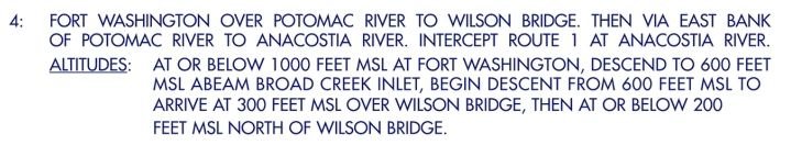
Of course in this case the thing known to degrade safety is "see and avoid", the regulator is the FAA, and the relevant parts of the user community appear to be "near as damn all of it". Focusing on the Army pilots' failure to achieve it would be a neat distraction from the much more difficult question (for everyone) of whether it is an appropriately safe means of separating from airline traffic. The nice NTSB diagram of Route 4 and the 75 feet spacing dodges the issue that neither the controller nor the Army pilots assumed that procedural separation existed; visual separation was being applied.
The permanent closure of Route 4 could be seen as acceptance that this was an unsafe basis on which to permit operations. However it still misses the point. The route was capable of being operated safely, for instance by holding helicopter traffic or avoiding use of runway 33 when needed to prevent conflictions, but that would have been tacitly to accept that visual separation was unsafe. Closing the route also only fixes the issue on one runway at one airport. Where next?
Last edited by Easy Street; 22nd March 2025 at 13:08 .
Subjects
ATC
FAA
NTSB
Route 4
See and Avoid
Separation (ALL)
Visual Separation
Links are to this post in the relevant subject page so that this post can be seen in context.
Reply to this quoting this original post. You need to be logged in. Not available on closed threads.
March 26, 2025, 08:23:00 GMT
permalink Post: 11854385
Subjects
ATC
CRJ
NTSB
Links are to this post in the relevant subject page so that this post can be seen in context.
Reply to this quoting this original post. You need to be logged in. Not available on closed threads.
October 21, 2025, 08:54:00 GMT
permalink Post: 11973542
Subjects
FAA
Links are to this post in the relevant subject page so that this post can be seen in context.
Reply to this quoting this original post. You need to be logged in. Not available on closed threads.
October 21, 2025, 14:54:00 GMT
permalink Post: 11973706
Also, as an aside the term "altitude" is typically used in aviation.
 (Yes, I know that DH for a precision approach is "decision height"...and HAT is shown on approach plates (Height Above Touchdown).
Why do I think the IFR ACS might be relevant? Because it specifies the accuracy the FAA requires of skilled pilots when separation is to be achieved by procedural means. The fact that the "designed" separation between the 33 approach slope and the top of Route 4 was less than the allowable error for skilled pilots could be used to rebut an allegation of negligent flying as the cause of the accident. The Army no doubt has its own standards document, but I'd be surprised if it was radically different. Building the argument off the FAA's own document forces the focus onto its route design and visual separation procedures.
As to why this might be relevant to VFR flying - is it your opinion that parameters should be flown more accurately in VFR than in IFR? In any case, I have now dug further into the ACS and the same tolerance is prescribed for commercial VFR helicopter operations (see CH.VII.A.S8).
Last edited by Easy Street; 21st October 2025 at 15:16 .
Subjects
FAA
IFR
Radio Altimeter
Route 4
Separation (ALL)
VFR
Visual Separation
Links are to this post in the relevant subject page so that this post can be seen in context.
Reply to this quoting this original post. You need to be logged in. Not available on closed threads.
October 21, 2025, 16:33:00 GMT
permalink Post: 11973744
Subjects
Blackhawk (H-60)
FAA
NTSB
Preliminary Report
Separation (ALL)
Links are to this post in the relevant subject page so that this post can be seen in context.
Reply to this quoting this original post. You need to be logged in. Not available on closed threads.
October 21, 2025, 18:22:00 GMT
permalink Post: 11973780
Subjects
Altimeter (All)
FAA
Radio Altimeter
Route 4
Separation (ALL)
Links are to this post in the relevant subject page so that this post can be seen in context.
Reply to this quoting this original post. You need to be logged in. Not available on closed threads.
October 23, 2025, 08:11:00 GMT
permalink Post: 11974792
I agree with you, by the way - my point being that the case for Army pilot negligence isn't as obvious as it might first appear.
Last edited by Easy Street; 23rd October 2025 at 08:56 .
Subjects
Blackhawk (H-60)
CRJ
FAA
Links are to this post in the relevant subject page so that this post can be seen in context.
Reply to this quoting this original post. You need to be logged in. Not available on closed threads.
December 20, 2025, 19:34:00 GMT
permalink Post: 12008689
Subjects
ADSB (All)
Night Vision Goggles (NVG)
Traffic in Sight
VFR
Links are to this post in the relevant subject page so that this post can be seen in context.
Reply to this quoting this original post. You need to be logged in. Not available on closed threads.
January 30, 2026, 09:27:00 GMT
permalink Post: 12029574
28. With several other targets located directly in front of the helicopter represented by points of light with no other features by which to identify aircraft type, and without additional position information from the controller, the instructor pilot likely identified the wrong target.
Subjects
ATC
Findings
PAT25
Separation (ALL)
Traffic in Sight
Visual Separation
Links are to this post in the relevant subject page so that this post can be seen in context.
Reply to this quoting this original post. You need to be logged in. Not available on closed threads.
January 31, 2026, 09:23:00 GMT
permalink Post: 12030100
Relatedly, the 200 foot maximum altitude might have given the impression that procedural separation was built in to the route design. Beyond 2.5 miles from the airport, it could perhaps have been used to establish procedural separation against traffic on a 3 degree glideslope (probably in conjunction with stepped descent minima for that traffic). But so close to the airport, route parameters could never have provided separation on their own.
Subjects
Radar
Separation (ALL)
Visual Separation
Links are to this post in the relevant subject page so that this post can be seen in context.
Reply to this quoting this original post. You need to be logged in. Not available on closed threads.