January 30, 2025, 09:16:00 GMT
permalink Post: 11817030
I suspect that this is either going to be one of those "we have been playing Russian Roulette for decades" investigations, or a normalization-of-deviance/boiled frog issue where a difficult situation has been made worse over time.
Factors in the boiled-frog situation would be more use of 15/33 as RJs have become more prevalent; not well regulated growth in helicopter traffic to the Pentagon; and a lot more lighting in the area.
DCA generally is a complex traffic situation with very regular go-arounds (the standard fly-out path is over my building so I hear them). I saw an RJ missing an approach to 15 just yesterday.
But one thing that I'm thinking now: there is no way in hell that a civilian heliport as busy as the Pentagon would be allowed 1,000 yards from a very busy final approach to an airport.
Last edited by LowObservable; 30th January 2025 at 10:03 .
Subjects
DCA
Links are to this post in the relevant subject page so that this post can be seen in context.
Reply to this quoting this original post. You need to be logged in. Not available on closed threads.
January 30, 2025, 15:24:00 GMT
permalink Post: 11817326
Subjects
Night Vision Goggles (NVG)
Links are to this post in the relevant subject page so that this post can be seen in context.
Reply to this quoting this original post. You need to be logged in. Not available on closed threads.
January 30, 2025, 16:20:00 GMT
permalink Post: 11817366
Subjects
Night Vision Goggles (NVG)
Links are to this post in the relevant subject page so that this post can be seen in context.
Reply to this quoting this original post. You need to be logged in. Not available on closed threads.
January 30, 2025, 16:22:00 GMT
permalink Post: 11817371
Providing a conflict-free path for them to do that is the most consistent solution.
However the ultimate issue is traffic density, and the control workarounds (that have been discussed at great length upthread) that the US has normalised to shoehorn huge movement numbers into tiny spaces.
This is probably one of those situations where there should be a military/very limited commercial use airport in the current location and the 'real' airport should be hanging off the end of a high-speed rail line about 50 miles away q.v. Hong Kong.
Subjects
ATC
Links are to this post in the relevant subject page so that this post can be seen in context.
Reply to this quoting this original post. You need to be logged in. Not available on closed threads.
January 30, 2025, 20:12:00 GMT
permalink Post: 11817613
IF this is a case of 'stuff happens' and not someone's serious error, maybe it's time to put human lives above the convenience of some politicians and close this airport.
DCA should not be inherently dangerous to operate. It does work under 9/11-legacy restrictions that make it harder to use than it should be and that should be reviewed at such time as the US has a non-lunatic government. But I suspect that a root cause in this tragedy will be the expansion of military helicopter traffic and the Pentagon's insistence on maintaining two routes out of central DC, one down 395 and the other down the Potomac. There will be questions too if the collision was well above the 200-foot limit on the helo corridor. There is no way that a busy civilian heliport would be tolerated so close to a flightpath.
Subjects
DCA
Links are to this post in the relevant subject page so that this post can be seen in context.
Reply to this quoting this original post. You need to be logged in. Not available on closed threads.
February 28, 2025, 23:10:00 GMT
permalink Post: 11838199
Go-arounds at DCA are a daily occurrence (the Lair is smack underneath the flyout path), sometimes multiple.
Subjects
DCA
Route 5
Links are to this post in the relevant subject page so that this post can be seen in context.
Reply to this quoting this original post. You need to be logged in. Not available on closed threads.
March 09, 2025, 15:21:00 GMT
permalink Post: 11843970
Almost as if there was no safety case behind the PAT operation.
Subjects
Route 5
Links are to this post in the relevant subject page so that this post can be seen in context.
Reply to this quoting this original post. You need to be logged in. Not available on closed threads.
March 10, 2025, 20:46:00 GMT
permalink Post: 11844860
For Low Observable: no, it's called "an overreaction"
- Military organizations and government organizations have a long history of doing stuff like that.
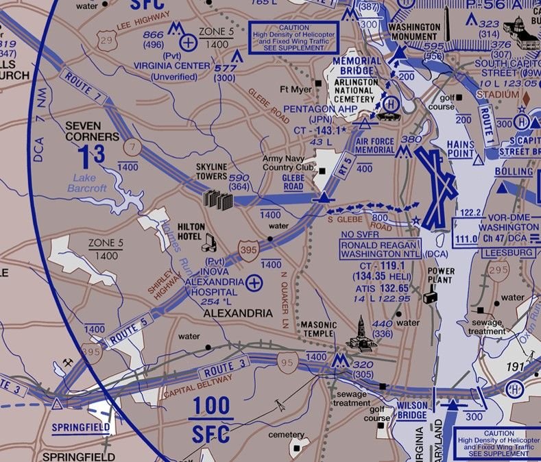
However, if you look at facts on the ground: Helos using Route 5 routinely followed I-395 and hooked around the east side of the Pentagon, which is closer to the RW15 piano keys than Route 4 is to RW33. Moreover, that stretch of roadway is elevated and has high-level lights, so the space under 200ft relative to river or runway level is that much tighter.
I also wonder how Route 5 traffic got tracked on DCA radar given high buildings and the Arlington ridge. .
Last edited by LowObservable; 10th March 2025 at 22:14 .
Subjects
DCA
Radar
Route 4
Route 5
Links are to this post in the relevant subject page so that this post can be seen in context.
Reply to this quoting this original post. You need to be logged in. Not available on closed threads.
March 11, 2025, 22:29:00 GMT
permalink Post: 11845719
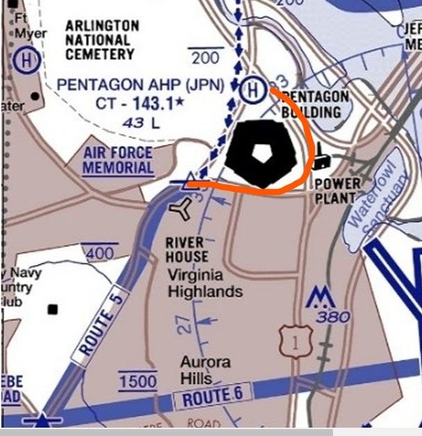
The chart shows the dotted routes connecting 1 and 5 to the Pentagon helipad. But much of the time, the PAT helos would fly the red line - as I observed earlier, over a raised highway with light poles, and cutting under the RW15 approach at about half the distance to the runway end.
I just base this on what I can see locally. I walk almost daily parallel to the rail line and it was no big deal to see the PATs following 395 around the east side of the building - but that's not where the chart says Route 5 is.
By the way a midair over 395 would put debris into a heavily used outdoor sports complex.
PS Observed two more go-arounds from RW18 this afternoon!
Subjects
Route 5
Links are to this post in the relevant subject page so that this post can be seen in context.
Reply to this quoting this original post. You need to be logged in. Not available on closed threads.
March 12, 2025, 02:11:00 GMT
permalink Post: 11845835
FAA Information for KJPN, effective 20 Feb 2025, has amongst Additional Remarks:—
CAUTION - TFC PAT - KJPN EAST/WEST OPS. SPECIAL PRO TFC PAT. WHEN LDG W ALL ARR ACFT MAKE LEFT TFC CIRCLING THE PENTAGON AT OR BLW 200 FT. WHEN DEP E ALL ACFT MAKE RIGHT TFC CIRCLING THE PENTAGON AT OR BLW 200 FTWhich is what they were not doing, at least on arrival. My vantage point for ops is about at the T on POWER PLANT on the map, so it was easy to see that the flightpath was east of the building.
Subjects: None
No recorded likes for this post (could be before pprune supported 'likes').Reply to this quoting this original post. You need to be logged in. Not available on closed threads.
March 12, 2025, 13:49:00 GMT
permalink Post: 11846223
One would hope traffic arriving/departing the Pentagon is coordinated tower to tower with DCA if traffic is approaching 15 and departing 33….
One would definitely hope that traffic is coordinated. From my perspective (17th floor, facing east) the Route 5 traffic is just above the level of the Arlington Ridge treeline as it enters my FOV and is then masked by high-rises as it follows the red line over 395. The terrain and buildings are next to 395 so the 196-foot tower can't see over them. Using GE Pro it looks as if the helos are seconds from the 15 approach before the tower has line of sight to them.
Last edited by LowObservable; 12th March 2025 at 14:07 .
Subjects
DCA
Route 5
VFR
Links are to this post in the relevant subject page so that this post can be seen in context.
Reply to this quoting this original post. You need to be logged in. Not available on closed threads.
March 12, 2025, 18:48:00 GMT
permalink Post: 11846398
Subjects
ATC
Route 5
Links are to this post in the relevant subject page so that this post can be seen in context.
Reply to this quoting this original post. You need to be logged in. Not available on closed threads.
March 13, 2025, 20:58:00 GMT
permalink Post: 11847047
Subjects: None
No recorded likes for this post (could be before pprune supported 'likes').Reply to this quoting this original post. You need to be logged in. Not available on closed threads.
March 31, 2025, 21:24:00 GMT
permalink Post: 11858201
Subjects
ADSB (All)
Route 5
Links are to this post in the relevant subject page so that this post can be seen in context.
Reply to this quoting this original post. You need to be logged in. Not available on closed threads.
April 25, 2025, 21:45:00 GMT
permalink Post: 11873648
Also, note that it is now clearly marked that the flightpath is to the West of the Pentagon. One wonders what the reviewers thought of the Apocalypse Now hard-banking stunts around the east side of the building under the 15 approach.
Subjects
Route 5
Links are to this post in the relevant subject page so that this post can be seen in context.
Reply to this quoting this original post. You need to be logged in. Not available on closed threads.
April 29, 2025, 15:34:00 GMT
permalink Post: 11875483
If this is about one pilot and one operation, and about a single error 15 seconds before a collision on Route 4, why does Route 5 remain almost completely shut down , and not by the FAA?
I have 100% visual and audible on every Route 5 movement from The Lair, even if I'm not at my desk. Seen two operations since the accident.
I suspect that the answer is this: someone reporting to DoD leadership, not Army aviation, came in, took one look at the ops and ops standards, screamed WHISKEY THE ALFA FOXTROT and observed that it was sheer blind luck the accident hadn't happened earlier, and possibly on the 15 approach with a dozen or so teenage soccer players added to the casualty list.
Last edited by LowObservable; 29th April 2025 at 16:19 .
Subjects
DEI
FAA
Route 4
Route 5
Links are to this post in the relevant subject page so that this post can be seen in context.
Reply to this quoting this original post. You need to be logged in. Not available on closed threads.
May 02, 2025, 23:28:00 GMT
permalink Post: 11877447
Looks like someone did exactly that today, forcing two go-arounds.
Subjects: None
1 recorded likes for this post.Reply to this quoting this original post. You need to be logged in. Not available on closed threads.
May 03, 2025, 12:55:00 GMT
permalink Post: 11877718
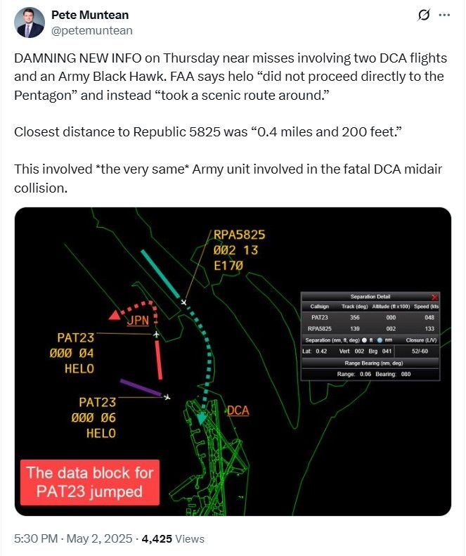
Unclear why PAT23 (and apparently other helicopters) fly counter-clockwise; i.e., continue to follow 395 S of Pentagon (past south parking), then turn N to follow 110 (past the Metro entrance) to the JPN landing pad. Why not use the charted transition route along 27/Washington Blvd?
Not a clue, but someone should ask - and, after Thursday, someone should be relieved of command. Because the helo didn't do one pass east of the Pentagon but two, making a circuit after causing the first go-around, and triggering a second. All the while in the ground clutter - hence the jump in data - and apparently, per BFSGrad, unresponsive to control.
The video is in a Twitter post by @STATter911. Cannot link here.
Subjects
DCA
PAT23
Links are to this post in the relevant subject page so that this post can be seen in context.
Reply to this quoting this original post. You need to be logged in. Not available on closed threads.
May 03, 2025, 21:08:00 GMT
permalink Post: 11877940
Owned by the Army
U.S.ARMY ATCA-ASO
CAMERON STA
ALEXANDRIA, VA 22314
The Army closed Cameron Station in 1995. Under navigation aids, Nottingham (OTT) Tacan listed as a VORTAC. The VOR portion of OTT was decommissioned at least a decade ago.
It's a posh townhouse development now. Used to have a nice Indian restaurant with belly dancers on weekends, but it did not make it through Covid.
Also, what the effing eff? Is that really the current information?
Subjects: None
No recorded likes for this post (could be before pprune supported 'likes').Reply to this quoting this original post. You need to be logged in. Not available on closed threads.
May 05, 2025, 15:34:00 GMT
permalink Post: 11878856
https://www.politico.com/news/2025/0...rport-00325195
\x91Take a taxi or Uber\x92: Duffy blasts Defense Department after incident in DC airspace
But...
Army says it was a training flight. Going off the charts twice on a training flight? At this time? Potential shenanigans detected.
Subjects
FAA
Links are to this post in the relevant subject page so that this post can be seen in context.
Reply to this quoting this original post. You need to be logged in. Not available on closed threads.