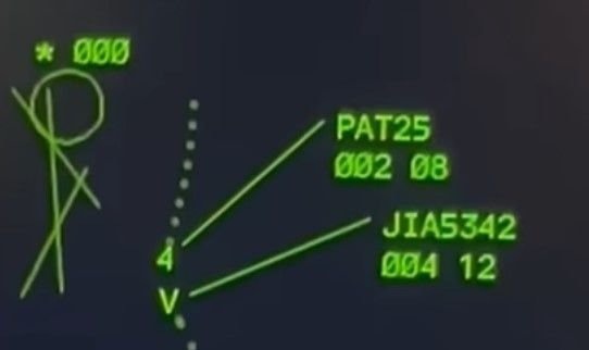
Dibo/fdr: keep wondering why the Hawk crew made that last correction to the right.
I don't think it make a significant turn right, and I believe that what you are seeing is positional inaccuracy due to MLAT position limitations in the ADS-B Exchange data. According to Flightradar24, "
MLAT position calculations have a general accuracy of 10-100 meters and 1000 meters in the worst cases." Given that, I believe this previous post from MikeSnow
AA5342 Down DCA
represents our best current understanding of the actual helicopter track and its relation to Route 4 (until we get more information from the NTSB). I generated my own zoomed overlay and got essentially the same results
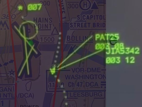
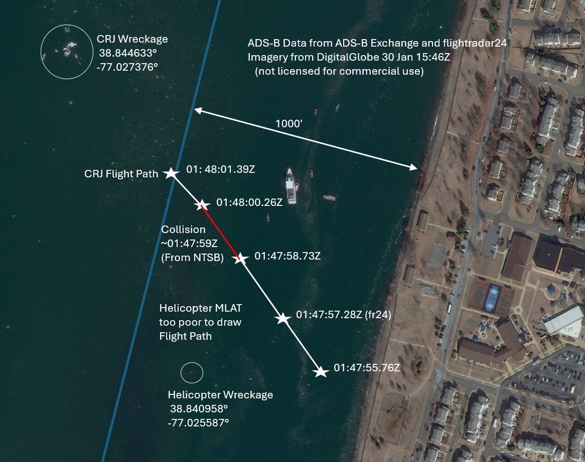
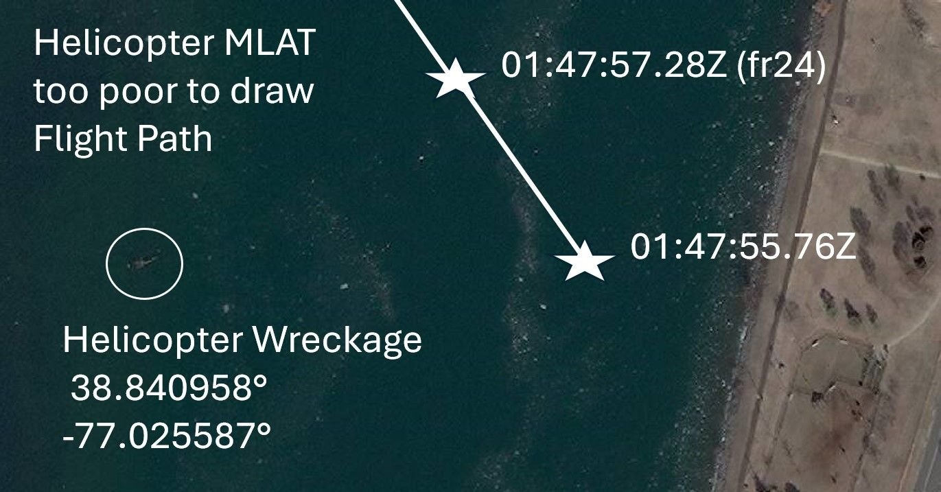
The position of the collision shown in the radar data overlay is consistent with the position of the RJ as shown in ADS-B Exchange at the time of the collision (approximately 01:47:59Z according to the NTSB timeline). See this link from DIBO for the RJ Track with timing
AA5342 Down DCA
In my experience, times in ADS-B Exchange are generally accurate to within 2 seconds. Given all that, I believe that the Black Hawk was within the horizontal bounds of Route 4 at the time of the collision and that it did not make the right turn we see in the ADS-B Exchange map.
Edit: Corrected route number and helicopter
Last edited by airplanecrazy; 6th February 2025 at
01:24
.
First of all: I can largely follow your Maths. In a straight line the PAPI is a bit less than1550m from the Eastern bank of the Potomac on a straight 328\xb0 course. At 3\xb0 this would be 270ft altitude when crossing the -east bank. Both aircraft ended up in the Potomac. When looking at the point of impact of the Blackhawk in the Potomac in these videos I end up with a spot ~1450m from the PAPI.
On the other hand the collision will have somewhat altered trajectory of both aircraft, so maybe the collision had still occured over land and due to the lateral energy transfer the Helicopter was thrown off its original course towards the West and into the river. We will get this information finally.
And in the end it doesn't really make that much of a difference wrt the level of lunacy of this whole setup.
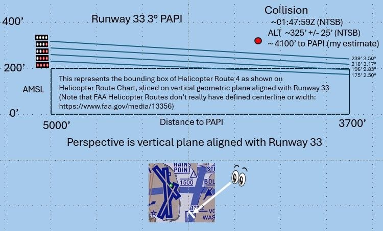
I think the collision was closer to 1250m (4100') from the PAPI. I base that upon the NTSB statement "
At 8:47:58, the crew had a verbal reaction, and FDR (flight data recorder) data showed the airplane beginning to increase its pitch. Sounds of impact were audible about one second later,"
That puts the collision at about 8:47:59 (01:47:59Z). ADS-B Exchange data at that time puts the ground distance to the PAPI between 1200-1280m (3900-4200'). My assumptions are that the NTSB statement is correct and that the ADS-B Exchange data is accurate (which in my experience, the times are generally less than 0.2 seconds later than the timestamps on data collected by the FAA, and the reported NACp (position accuracy) was estimated at < 10m). Here is the graphical representation I generated of my estimated collision position vs. PAPI.
Collision Altitude vs PAPI
Originally Posted by
galaxy flyer
Having been in a mid-air collision with similar geometry, I would bet it was only normal input to approach path. FDR’s are incredibly sensitive recorders. I have a vague memory of the other plane’s wing flashing by. It looks slow in the videos, but it’s incredibly fast.
If my depiction is accurate, it's hard to see why they would pitch up as normal input to approach path. I think their inputs would have been focused on getting down.
Last edited by airplanecrazy; 11th February 2025 at
06:30
.
Reason: Problem with picture. Awkward phrasing
SubjectsADSB (All)Blackhawk (H-60)FAANTSB
Links are to this post in the relevant subject page so that this post can be seen in context.
No recorded likes for this post (could be before pprune supported 'likes').
I’m not sure your quoting FAA helicopter routes as having no defined centreline or width would strictly apply in DC versus what they wrote about the North Shore of Long Island route in NYC where they are required to be 1 mile off the shoreline. As shown on the published helo chart (DIBO’s post #863, and your little chart insert) and in writing (BuzzBox’s post #998) Route 4 directs traffic to track “via the east bank of the Potomac” from the Wilson Bridge to Anacostia River. If the impact point was 1000 feet or so (give or take some trig) from the east bank of a 3000 feet wide river at that point wouldn’t this mean that PAT25 was not only too high but off track too? Otherwise according to your graphic even at 200 feet max elevation, being that distance from the east bank any helicopter not maintaining visual separation could collide if an AC was still positioning itself from being low on the glideslope.
My understanding is that the FAA depicted width of a helicopter route is governed by the following doc:
https://www.faa.gov/air_traffic/flig...2-complete.pdf
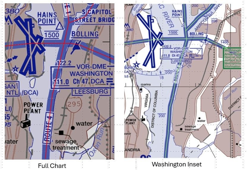
. It specifies that on a fully printed chart the route should be 0.1 inches wide regardless of chart scale. The chart I pulled from was 1:125,000 scale (full chart size is 51x33 inch poster), which would mean the routes "appear" to be 125,000 * 0.1 / 12 = 1,042 ft wide. In the same FAA chart package
https://aeronav.faa.gov/visual/12-26...-Wash_Heli.pdf
, the third page is a "Washington Inset" with a scale of 1:62,500. In that inset the routes "appear" to be 62,500 * 0.1 /12 = 521 ft wide. Also, if you look at the centerlines of the routes depicted on those two pages (which I "drew in" below), they do not exactly match. For example, look at how the full chart shows the route going east of Hains Point while the inset shows it very close to Hains Point.
DCA Helicopter Routes
Given these chart differences, I wonder how far a helicopter can stray from the various depictions of a route before it is considered a pilot deviation? Perhaps the NTSB will give us some insight with their accident report.
Last edited by airplanecrazy; 14th February 2025 at
23:53
.
Reason: Emphasize the route "appear"
I think that the "width" that you are referring is for the chart maker but not the actual width of a helicopter route.
I can't find in any FAA document a definition of the lateral extent of a helicopter route. Is there one?
Today's briefer said: "On this chart, you'll see the routes they were generally following Helicopter Route 1 to Helicopter Route 4. These routes are designated by the Federal Aviation Administration (FAA), and - although you see blue lines - there are no defined boundaries to these routes."
SubjectsFAARoute 4
Links are to this post in the relevant subject page so that this post can be seen in context.
Excerpt from Feb 14 NTSB Briefing Points on Mid-Air Collision near DCASo nothing yet reported on the CRJ CVR when maximum elevator was applied.
I was once stopped at a red light, began rolling when the light turned green - and suddenly found myself on the brakes before I was conscious of the car running the red light. Possibly a CRJ pilot similarly caught the helo in peripheral vision and reacted subconsciously.
In a prior briefing the NTSB said that the crew of the CRJ \x93had a verbal reaction\x94 to something, and flight data showed the plane beginning to increase its pitch. A second later there was a sound of the collision.
SubjectsCRJCVRNTSB
Links are to this post in the relevant subject page so that this post can be seen in context.
No recorded likes for this post (could be before pprune supported 'likes').
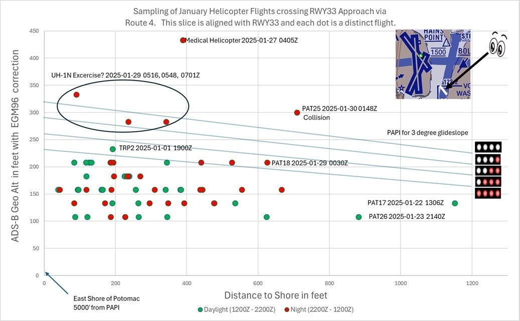
Out of curiosity, I was wondering how \x93out of the ordinary\x94 the flight path was for PA25 compared to other flights along Route 4. I found 65 such flights in January (there are probably some I missed) and I plotted where they crossed the runway approach. Note that the altitude is binned in 25' chunks, so you should assume that all altitudes just above 200' were actually at 200'. For any aircraft above 200' I DID NOT try to determine if they received clearance from ATC (which is permitted), and you SHOULD NOT assume that they didn't. I also threw in a rough breakout between daylight and night for each crossing. For the two PAT flights well offshore, I did not investigate any special ATC clearances they had. I apologize in advance for any errors as it is a bit tricky to plot and measure these distances.
Added note: The chart shows only crossings collected with ADS-B. I threw out all MLAT collected crossing because of inherent inaccuracy.
Helicopters crossing RWY 33 approach via Route 4 for January
Last edited by airplanecrazy; 19th February 2025 at
22:26
.
SubjectsADSB (All)ATCRoute 4
Links are to this post in the relevant subject page so that this post can be seen in context.
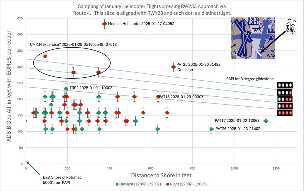
I really like your diagram: it presents data in a way that tells a coherent and compelling story. However I don't agree with the assumption above. A better assumption is that the geo altitude at each point is the recorded value, plus or minus 12.5 feet. Assuming you have built this in Excel, it will be easy to put error bars of that size on each of your data points.
(I've assumed that the altitude is recorded in the closest bin to the actual value. If that's not the case then the error bars would be 25 feet in one direction or the other depending on whether it rounds up or down. An ADSB geek would know. I am also itching to know whether the origin point of your glidepath lines has been adjusted to the same EGM96 height datum as the ADSB values...)
Thanks for the suggestion. I am not a GPS expert either, but it is easy to defend error bars of at least 10' horizontal and 15' vertical (based upon both ADS-B quantization and inherent GPS resolution). I have updated the chart below with those error bars below, and I will update it again if an expert gives me better values. Given your feedback, I would change my statement to say that all depicted values near 200' are consistent with the aircraft being at or below 200', and readers should not assume those flights exceeded the limit.
As for your question on the glideslope, I did NOT properly account for the EGM96 correction. The new chart moves the glideslope up 5' to meet the height of the PAPI as measured in Google Earth (18'), which uses EGM96. Is that reasonable? I should also add a couple of feet to account for the height of the PAPI lights themselves. Does anyone know how much I should add? Thanks for the catch.
Helicopters crossing RWY 33 approach via Route 4 for January (updated)
Last edited by airplanecrazy; 19th February 2025 at
23:49
.
Reason: Adjusted PAPI lights up 5 feet
SubjectsADSB (All)Route 4
Links are to this post in the relevant subject page so that this post can be seen in context.
Did you take QNH into account ? Ads-B gives pressure altitude
I used ADS-B reported GEO Altitude as my source and added the EGM96 correction for the lat/long of KDCA. Given that, nothing in the chart is derived from pressure altitude. As an aside, I did take a look at QNH adjusted pressure altitude (to get calibrated altitude) and it was largely in agreement with Geo Altitude. The exceptions were two helicopters N11PP and N22PP, and I don't know if it is something I am doing wrong in my calculations or something wrong with their ADS-B equipment.
SubjectsADSB (All)KDCAQNH
Links are to this post in the relevant subject page so that this post can be seen in context.
No recorded likes for this post (could be before pprune supported 'likes').