henra January 30, 2025, 10:31:00 GMT permalink
Post: 11817100
The nasty thing about 'see and avoid' is that exactly the stationary situations where relative position/angle does not change is the collision setup. And this over a sea of lights of a big city at night.
Almost astonishing that this hasn't happened earlier
Last edited by Saab Dastard; 30th January 2025 at
15:17
.
Reason: Reference to deleted post removed
SubjectsSee and Avoid
Links are to this post in the relevant subject page so that this post can be seen in context.
henra January 30, 2025, 20:22:00 GMT permalink
Post: 11817621
Originally Posted by
Luc Lion
Adding an additional slice of cheese in the sandwich is very easy: just state that when 2 tracking routes provide less than 500 ft of separation, then they are mutually exclusive.
This is the really puzzling part. Looking at the expected altitude of an approaching Airliner with a 3\xb0 G/S at the expected crossing point it would be at 250 ft +/-50 That leaves a mere 0-100ft to the helicopter route (and that is assuming the Helo path along the East side of the Potomac, if it deviates somewhat to the West the default altitude of the Airliner will drop below 200ft at the crossing). This is simply insane. You could count the number of bolts in the rotor head if everything goes according to plan. If not -well we saw that last night. How can this be allowed? What was the plan? Did ATC assume the Helo would duck under? At night over water? And visual separation in case of a circle to land -not a straight in- at night? Courageous. Note to self: Never take a flight into DCA.
henra January 31, 2025, 08:15:00 GMT permalink
Post: 11817977
Originally Posted by
Ollie Onion
It seems pretty clear what happened.
I agree. Having learned the concept, responsibility and geometry of these procedures, approaches and airways in DCA the biggest mystery that remains to me is: Why didn't it happen before?!
SubjectsDCA
Links are to this post in the relevant subject page so that this post can be seen in context.
henra January 31, 2025, 13:41:00 GMT permalink
Post: 11818215
Originally Posted by
Rarife
It is really like that? Yes, I have seen the map but honestly I don't know how it works in real life. Do they really just fly bellow aircraft on final with vertical separation like 100-200 ft or they have to avoid them, let's say cross behind. What is too close in this case?
That's what I'm also wondering. And assuming a standard 3\xb0 glideslope the vertical separation at that point would be even rather less than 100ft. I can't really fathom crossing 50-100ft above the whirly bits of a Blackhawk being a regularly executed standard procedure !? What is the 'normal' way of doing this in DCA?
henra January 31, 2025, 14:56:00 GMT permalink
Post: 11818270
Originally Posted by
gpn01
The right question is how can lessons be applied to prevent it from happening again?
Probably not without major changes. Having a Helo route crossing below an approach where Airliners are expected to be in a range between 200 and 300ft and descending will not leave any really safe option. Asking Helos to stop and wait until released by ATC for crossing may be an option but will bring some added risks to the Helicopters when asked to hold short. Hovering at night is surely not ideal especially in IMC/limited visibility situations. Plus a small remaining risk of ATC fu** up.
Another option might be to lift the Helo route to >1000ft (leaving still some albeit remote potential for a freak accident) or even better to move it elsewhere. Or to close the Airport. However all these alternatives do come at a cost. Obviouls no simple No- brainer answers otherwise it would have already been implemented.
SubjectsATC
Links are to this post in the relevant subject page so that this post can be seen in context.
henra January 31, 2025, 15:07:00 GMT permalink
Post: 11818276
Originally Posted by
Lascaille
Also, why were they above the 200ft route ceiling?
When measuring the length of the Blackhawk in that CNN vid vs. the height above the Potomac I end up at ~250 - 280ft. In this case surely tragic but 50ish ft high does not really seem a lot, especially at night in a high workload situation possibly on goggles.
SubjectsBlackhawk (H-60)CNN
Links are to this post in the relevant subject page so that this post can be seen in context.
No recorded likes for this post (could be before pprune supported 'likes').
henra February 01, 2025, 16:56:00 GMT permalink
Post: 11819164
Originally Posted by
megan
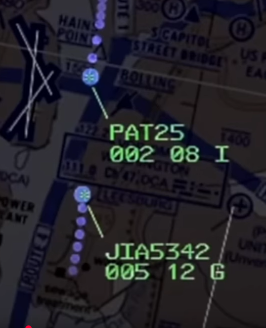
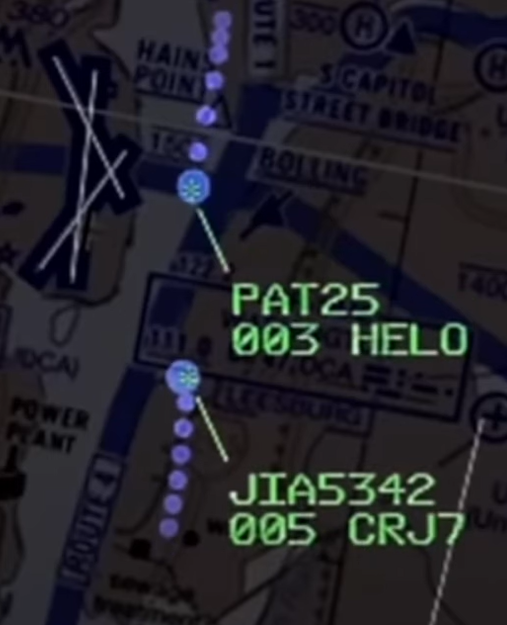
From the radar pics below might the helo pilots have their attention outside of the cockpit searching for the traffic, with no one minding the store (instrument scan break down) they unwittingly climb a 100 feet from their previous 200 feet.
It hasn't necessarily climbed 100 feet. sinc display resolution is only 100ft it could be that it climbed from 240 to 260ft between these two screens. Besides this it also shows how ludicrous this 100ft vertical separation in this case was. Even the ATC screens resolution do not really support this level of separation. 245ft would still have shown as 002 and if in the middle of the Potomac the 3\xb0 G/S would be already lower than this.
henra February 02, 2025, 16:21:00 GMT permalink
Post: 11819897
Originally Posted by
cbradio
ATC did do what he is "supposed" to do. The Blackhawk was told to "pass behind". Nothing to do with vertical separation. It's a form of separation. That's how it works. Thousands of times every day, all over the place.
But why didn't the controller intervene then when the Helo kept closing in? What horizontal separation did he deem OK?
henra February 03, 2025, 13:06:00 GMT permalink
Post: 11820522
Originally Posted by
Old Boeing Driver
Had PAT25 been on the east coast of the Potomac, and at or below 200 feet, this accident would not have happened.
Mechanically correct. But do you consider this a safe assumption/solution? Where technically everything needs to be (triple)redundant and engineering wise brought with enormous effort to extremely high safety standards. And then you hope no one deviates at night in low level flight 100ft in altitude or a couple of hundred feet in track?
Just a different opinion.
SubjectsPAT25
Links are to this post in the relevant subject page so that this post can be seen in context.
henra February 03, 2025, 18:37:00 GMT permalink
Post: 11820784
Originally Posted by
Luc Lion
Edit: after correcting the calculation with the fact that the PAPI is 350 ft before the TDZ, the angle for 325 ft altitude is rather 3\xb0 48 minutes, well into the 4 whites range.
First of all: I can largely follow your Maths. In a straight line the PAPI is a bit less than1550m from the Eastern bank of the Potomac on a straight 328\xb0 course. At 3\xb0 this would be 270ft altitude when crossing the -east bank. Both aircraft ended up in the Potomac. When looking at the point of impact of the Blackhawk in the Potomac in these videos I end up with a spot ~1450m from the PAPI.
On the other hand the collision will have somewhat altered trajectory of both aircraft, so maybe the collision had still occured over land and due to the lateral energy transfer the Helicopter was thrown off its original course towards the West and into the river. We will get this information finally.
And in the end it doesn't really make that much of a difference wrt the level of lunacy of this whole setup.
SubjectsBlackhawk (H-60)
Links are to this post in the relevant subject page so that this post can be seen in context.
No recorded likes for this post (could be before pprune supported 'likes').
henra February 03, 2025, 18:43:00 GMT permalink
Post: 11820790
Originally Posted by
YRP
Either way, the controller does not have enough information to use a heading — neither to know one is needed nor what it should be . The radar & display is just not as accurate as a Mark I eyeball in one cockpit seeing the other plane out the window.
Hmmm. Dunno. Would you really expect this maneuver to be executed in such proximity that it can't be reliably resolved by the radar accuracy? At night? In a 45\xb0 head- on angle of the two flight paths? Your comfort zone for sure is a different one than mine would be.
SubjectsATCRadar
Links are to this post in the relevant subject page so that this post can be seen in context.
No recorded likes for this post (could be before pprune supported 'likes').