January 30, 2025, 05:14:00 GMT
permalink Post: 11816887
Subjects: None
No recorded likes for this post (could be before pprune supported 'likes').Reply to this quoting this original post. You need to be logged in. Not available on closed threads.
January 30, 2025, 05:33:00 GMT
permalink Post: 11816897
The Black Hawk took off from Fort Belvoir, Va., defense officials said, and was part 12th Aviation Battalion. The battalion is responsible for transporting VIP passengers, usually top Pentagon leaders. There were three crew members on board, the officials said, but none were VIPs.
The three troops on board the Black Hawk were conducting a training flight, according to a spokeswoman Joint Task Force-National Capitol Region.
\x93We can confirm that the aircraft involved in tonight\x92s incident was an Army UH-60 helicopter from Bravo Company, 12th Aviation Battalion, out of Davison Army Airfield, Fort Belvoir during a training flight. We are working with local officials and will provide additional information once it becomes available,\x94 the spokeswoman said.
Usually, such flights are manned by a pilot, instructor pilot and crew chief.
Subjects
Blackhawk (H-60)
CNN
Wall Street Journal
Links are to this post in the relevant subject page so that this post can be seen in context.
Reply to this quoting this original post. You need to be logged in. Not available on closed threads.
January 30, 2025, 13:20:00 GMT
permalink Post: 11817228
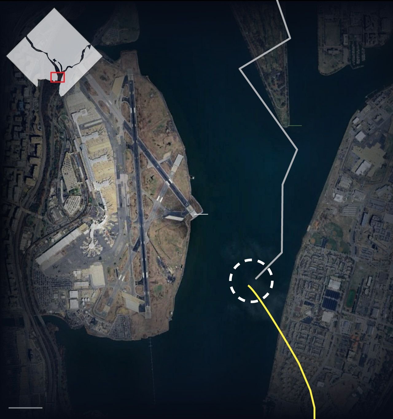
Or could the circling approach from 01 to 33 also be a factor with the helo misinterpreting the CRJ flight path and somehow losing sight ? The track of both aircraft is interesting… helo seems to initially be parallel to the river bank and turns 40 right. Why ? Was their destination the same airport or was that manoeuvre related to traffic avoidance or loss of visual ?
All guesswork I know… putting Special VFR traffic so close to final approach traffic at night clearly a problem. Tragic.
The golf course is on a peninsula in the river, so the helicopter was flying over water before and after it made the two turns.
Subjects
CRJ
Circle to Land (Deviate to RWY 33)
VFR
Links are to this post in the relevant subject page so that this post can be seen in context.
Reply to this quoting this original post. You need to be logged in. Not available on closed threads.
January 30, 2025, 14:32:00 GMT
permalink Post: 11817282
You could contact them if you want and tell them it\x92s wrong. No offense intended.
Even if it wasn\x92t a sharp turn, it was done over a golf course and their flight path was probably dictated by noise abatement reasons, as are those flown by jets flying into DCA.
Subjects
ATC
DCA
Radar
Route 4
Links are to this post in the relevant subject page so that this post can be seen in context.
Reply to this quoting this original post. You need to be logged in. Not available on closed threads.
January 30, 2025, 16:48:00 GMT
permalink Post: 11817397
Subjects
Altimeter (All)
Links are to this post in the relevant subject page so that this post can be seen in context.
Reply to this quoting this original post. You need to be logged in. Not available on closed threads.
January 30, 2025, 23:25:00 GMT
permalink Post: 11817757
Who cares if it is a municipal golf course or not, because nobody is going to play golf at around 8:40 PM in the dark of night.
My point was that helicopters might fly over it because nobody would care about the noise, and people in residential neighborhoods do, whether the residential neighborhoods are officially listed as a noise abatement areas or not.
https://www.flyreagan.com/about-airp...raft-noise-faq
Last edited by visibility3miles; 31st January 2025 at 01:39 .
Subjects
FAA
Links are to this post in the relevant subject page so that this post can be seen in context.
Reply to this quoting this original post. You need to be logged in. Not available on closed threads.
January 31, 2025, 16:06:00 GMT
permalink Post: 11818320
BTW, the Potomac River is subject to sea tides by the airport, so that can’t help in the recovery, plus it was carrying a lot of melted snow at the time, adding to the cold and volume.
It’s been on the news 24/7 around here.
Anyway, there are a few stories in the Washington Post that might be of interest, or completely irrelevant:
https://www.washingtonpost.com/dc-md...eagan-airport/
Schulman said he saw sparks spreading along the plane, nose to tail, as the aircraft banked sharply to the right.
“I couldn’t make sense of what I saw because it didn’t seem like they were coming directly out of the plane,” Schulman said. “They were underneath its belly and separated a little distance.” Schulman, who said he has reported on plane crashes but never seen one up close, was shaken by the experience. “I pray that there are many survivors,” he said.
He shared a detailed description of what he saw on X
… On Wednesday evening, the position of helicopter controller — a role typically staffed until 9:30 p.m. — had been combined ahead of the crash with that of local controller, according to the report. Doubling up those roles can create challenges for an air traffic controller, especially if the airspace is busy. The roles use different radio frequencies, and airplane pilots and helicopter pilots cannot necessarily hear each other even if they’re both in touch with the tower.
Subjects
ATC
DCA
Thread Moderation
Links are to this post in the relevant subject page so that this post can be seen in context.
Reply to this quoting this original post. You need to be logged in. Not available on closed threads.
February 03, 2025, 12:44:00 GMT
permalink Post: 11820506
https://www.washingtonpost.com/dc-md...ues-point-dei/
Crews are set to begin lifting a catastrophically damaged American Airlines regional jet from the bottom of the Potomac River in Washington on Monday, five days after the plane and an Army helicopter collided in a fiery crash that left no survivors .
What’s left of the plane will be carefully brought to the surface with the help of Navy salvage experts and specialized dive teams who have been rehearsing the effort, according to Col. Francis Pera, the Baltimore district commander for the U.S. Army Corps of Engineers, which is helping oversee the work.
The Army Corps said the process could take three days to complete. The aircraft will be hoisted out of the water with a crane and onto a barge, then covered by a large tent, providing “full discretion” for human remains that may still be on board, Pera said.
Last edited by visibility3miles; 3rd February 2025 at 13:00 . Reason: Adding quote about NOTAM
Subjects
Blackhawk (H-60)
DCA
FAA
NTSB
Links are to this post in the relevant subject page so that this post can be seen in context.
Reply to this quoting this original post. You need to be logged in. Not available on closed threads.
April 20, 2025, 18:01:00 GMT
permalink Post: 11870642
https://media.istockphoto.com/id/125...gcSoTmRDpMdzk=
Subjects
See and Avoid
Traffic in Sight
Links are to this post in the relevant subject page so that this post can be seen in context.
Reply to this quoting this original post. You need to be logged in. Not available on closed threads.
April 27, 2025, 12:51:00 GMT
permalink Post: 11874368
Missteps, Equipment Problems and a Common but Risky Practice Led to a Fatal Crash
New details revealed by The Times show that the failures on Jan. 29 before an Army helicopter crashed into a jet near Reagan National Airport were far more complex than previously known.https://www.nytimes.com/2025/04/27/b...smid=url-share
Subjects: None
No recorded likes for this post (could be before pprune supported 'likes').Reply to this quoting this original post. You need to be logged in. Not available on closed threads.