June 18, 2025, 05:34:00 GMT
permalink Post: 11904895
FR24 did do that raw ADS-B data comparison. Remember the GPS position and barometric altitude are sent by the aircraft itself. The altitude is sent in 25 ft intervals, so a shallow curve that is smooth in reality looks janky in the data, due to the rounding of the numbers. From https://www.flightradar24.com/blog/f...rom-ahmedabad/ :

Obviously the altitudes are all uncorrected for barometric pressure, which would've varied with the weather on that day; you kind of have to mentally shift the lines vertically downward. Now I looked for, but couldn't find, the post in the old thread where the rotation was triangulated\xb9, but I remember that it was near the turnoff to the high-speed taxiway, so a few seconds ahead of this ADS-B capture. We only have the video to show us what occurred then.
That means the ADS-B data doesn't really tell us whether the first few seconds of the climb were normal or not.
When we compare the red line to the blue lines, the data tells us the climb rate had already decayed significantly before the accident aircraft passed over the end of the runway, because the red flight path is much more shallow than the blue flight paths.
Please correct me if I'm wrong: to my eye, the data alone does not show that the engines must have failed after rotation, because the data does not demonstrate a normal climb rate.
But likewise, the engines can't have failed much before rotation:
-----
\xb9 I found one of them, anyway. The reference is the CCTV video:
Last edited by Musician; 18th June 2025 at 18:43 . Reason: footnote 1
Subjects
ADSB
AI171
CCTV
Engine Failure (All)
Engine Shutdown
FlightRadar24
Links are to this post in the relevant subject page so that this post can be seen in context.
The thread is closed so there are no user likes are available and no reply is possible.
June 18, 2025, 14:57:00 GMT
permalink Post: 11905272
FR24 did do that raw ADS-B data comparison. Remember the GPS position and barometric altitude are sent by the aircraft itself. The altitude is sent in 25 ft intervals, so a shallow curve that is smooth in reality looks janky in the data, due to the rounding of the numbers. From https://www.flightradar24.com/blog/f...rom-ahmedabad/ :
The red line is the accident flight, and it covers approximately 4.3 seconds.
Obviously the altitudes are all uncorrected for barometric pressure, which would've varied with the weather on that day; you kind of have to mentally shift the lines vertically downward.
Wouldn't that only be true if the altimeter setting was the same on all the days those flights were made? Isn't that improbable?
Subjects
ADSB
FlightRadar24
Links are to this post in the relevant subject page so that this post can be seen in context.
The thread is closed so there are no user likes are available and no reply is possible.
June 18, 2025, 16:17:00 GMT
permalink Post: 11905327
1. The aircraft reached an altitude AGL rather more than one wingspan. This can be clearly seen in the still from the CCTV video posted by Cape Bloggs on 2025-06-18 at 0401. The 787-8 wingspan is 197+ ft. So it got at least 200 feet up in the air. (Info from CCTV screen shot.)
2. (a) Ground effect on lift essentially disappears on TO when the wheels are at screen height. (Info from an eminent colleague who performed the analysis.) I believe it follows that (b) he didn't get up to 200 ft by performing a zoom climb on unstick. It further follows that (c) there must have been some initially adequate lift out of GE to establish for a few seconds positive RoC.
3. The FR24 graphic posted by Musician shows that the aircraft became initially airborne "as usual", compared with other TO profiles. (Info from FR24.)
4. The aircraft lacked adequate thrust even to maintain altitude shortly after unstick.
5. Flaps 5 is minimal for TO. If you don't set it, you are told very clearly that you are misconfigured, well before TO roll. (Info from others.)
6. At Flaps 5 and likely loading (fuel, PAX, token sum for baggage) and in the atmospheric conditions pertaining, there is more than enough nominal thrust available to establish positive RoC. That obviously also holds for Flaps-more-than-5. (Info from others.)
I am not au fait with audio spectral analysis so, unlike some others here, including some whose views and experience I value highly, I am agnostic at this point about the RAT. (This is neither to deprecate those who performed this analysis, nor the views of those who know more about practical spectral analysis than I do and are convinced by it.)
Now for my personal inference so far from this.
Items 2 and 3 above suggest to me that the aircraft was adequately configured to conduct a normal TO and initially establish positive RoC for a second or two.
For me, the big question is: why wasn't there adequate thrust to maintain that? (We've been talking about those possibilities for some days now - I won't attempt to summarise.)
PBL
Last edited by T28B; 18th June 2025 at 16:33 . Reason: slight formatting assist
Subjects
CCTV
FlightRadar24
RAT (All)
Links are to this post in the relevant subject page so that this post can be seen in context.
The thread is closed so there are no user likes are available and no reply is possible.
June 18, 2025, 16:48:00 GMT
permalink Post: 11905349
The FR24 data shows that, for the accident flight, the first data point received on takeoff was one that included altitude. We know where the aircraft was and we know the uncorrected baro altitude at that point.
We do not know how the altitude of that first point compares to the altitude of the reference flights unless all flights have their altitude adjusted by the prevailing altimeter correction.
Each trace starts in about the same place over the runway but this may not be useful data. I don't think this is the ADS-B ground/air transition. I think it is the point at which reception of ADS-B data becomes possible because of transmission "line of sight". We don't know if data starts being received as a result of increased altitude or because of passing by whatever was blocking the signal.
I'm sure someone could research the altimeter setting for each of the reference flight and produce a corrected data set. That would be interesting and useful data.
That's just my interpretation of the data I have seen. It is not presented as fact.
Last edited by EXDAC; 18th June 2025 at 17:17 . Reason: typo fix
Subjects
ADSB
FlightRadar24
Links are to this post in the relevant subject page so that this post can be seen in context.
The thread is closed so there are no user likes are available and no reply is possible.
June 18, 2025, 16:54:00 GMT
permalink Post: 11905352
1. The aircraft reached an altitude AGL rather more than one wingspan. This can be clearly seen in the still from the CCTV video posted by Cape Bloggs on 2025-06-18 at 0401. The 787-8 wingspan is 197+ ft. So it got at least 200 feet up in the air. (Info from CCTV screen shot.)
2. (a) Ground effect on lift essentially disappears on TO when the wheels are at screen height. (Info from an eminent colleague who performed the analysis.) I believe it follows that (b) he didn't get up to 200 ft by performing a zoom climb on unstick. It further follows that (c) there must have been some initially adequate lift out of GE to establish for a few seconds positive RoC.
3. The FR24 graphic posted by Musician shows that the aircraft became initially airborne "as usual", compared with other TO profiles. (Info from FR24.)
4. The aircraft lacked adequate thrust even to maintain altitude shortly after unstick.
5. Flaps 5 is minimal for TO. If you don't set it, you are told very clearly that you are misconfigured, well before TO roll. (Info from others.)
6. At Flaps 5 and likely loading (fuel, PAX, token sum for baggage) and in the atmospheric conditions pertaining, there is more than enough nominal thrust available to establish positive RoC. That obviously also holds for Flaps-more-than-5. (Info from others.)
I am not au fait with audio spectral analysis so, unlike some others here, including some whose views and experience I value highly, I am agnostic at this point about the RAT. (This is neither to deprecate those who performed this analysis, nor the views of those who know more about practical spectral analysis than I do and are convinced by it.)
Now for my personal inference so far from this. Items 2 and 3 above suggest to me that the aircraft was adequately configured to conduct a normal TO and initially establish positive RoC for a second or two. For me, the big question is: why wasn't there adequate thrust to maintain that? (We've been talking about those possibilities for some days now - I won't attempt to summarise.)
PBL
But you ask..... How can an aircraft possibly get airborne with a stalled wing? Look at Air France 7775 . At rotate the wing was already stalled (albeit for different reasons) but the airborne profile of the aircraft was rather similar to Air India.
Subjects
CCTV
FlightRadar24
RAT (All)
TOGA
V2
Links are to this post in the relevant subject page so that this post can be seen in context.
The thread is closed so there are no user likes are available and no reply is possible.
June 19, 2025, 21:35:00 GMT
permalink Post: 11906349
I'm commenting to make that point but also to link the videos and the FR-24 dataset - (below with my deltas for height/time added)

Extract from FR24 csv dataset
As noted in both threads to date everything was normal until it wasn't - the two values for fpm above are subject to FR24 variance of +/- 25' so even these suggest a normal climb at this stage of flight ca 2,000fpm. FR24 Lat/Longs all follow the centre line.
On this data the climb stops at around 70' AGL and electrical failure around 2s later. Again, as noted in the threads, this aligns with when gear up might have been expected. If the climb stopped because of fuel shutoff then 2s for spool down to electrical failure isn't out of the question.
Looking at the two videos.
The CCTV video indicates a total flight time, from rotation, of about 32s, subjectively levelling off ~14s after rotation.
The rooftop video has a flight time ~14s suggesting the video starts ~18s after rotation.
The rooftop video evidences the RAT as deployed from the beginning - meaning it must have been deployed by at least 16s after rotation - which aligns with the ADS-B indicated electrical failure.
If the forward flight recorder really is being sent to the US for recovery then it's reasonable to assume that the rear recorder contains nothing after the electrical failure and they are hoping the forward recorder captured something from the cockpit in the final 16s.
I don't have any experience of flight deck CRM but I don't see how those timings allow problem identification/misidentification and subsequent action - ie it wasn't down to the crew.
However:
The maximum aircraft height in the CCTV video, as judged by wingspan, appears higher than 71' - though it is certainly less than a wingspan height at the beginning of the rooftop video.
I haven't seen, in the threads, any statement of what happens on the flight deck with a total electrical failure - is it a 4s blackout whilst the RAT deploys and systems restart? - or are there batteries that keep something alive?
Subjects
ADSB
CCTV
DFDR
Electrical Failure
FADEC
FlightRadar24
RAT (All)
RAT (Deployment)
Relight
Links are to this post in the relevant subject page so that this post can be seen in context.
The thread is closed so there are no user likes are available and no reply is possible.
June 20, 2025, 02:11:00 GMT
permalink Post: 11906519
I have watched the video's and looked at the FR-24 data a hundred times. To me it looks like a normal rotation and at WoW everything starts to go wrong.
Airspeed starts dropping off immediately going by the FR-24 data. If reports are correct the pilot makes his Mayday call. FR-24 data stops.
In the video from the balcony I agree the RAT is out and operating but I can also hear the engines at idle or just above (maybe flight idle).
If the captain manually deployed the RAT this makes sense to me. In both video's I don't see any aircraft behavior that would suggest they are not flying the aircraft.
Is there an electrical fault at WoW that renders the cockpit dark and therefore manually deploying the RAT (possibly initiating APU start, inlet door is open at crash site) would make sense to restore cockpit power.
I can't understand any pilot shutting down both engines at 200ft AGL. He would surely know that his fight is over at that point.
I am not ruling out pilot error (configuration or otherwise) but my hat goes off to two pilots that I believe were trying to fly this aircraft until it hit the ground.
Sorry if my wording is a bit off but mine is military background not commercial.
Subjects
APU
Electrical Failure
FlightRadar24
MAYDAY
RAT (All)
RAT (Deployment)
Links are to this post in the relevant subject page so that this post can be seen in context.
The thread is closed so there are no user likes are available and no reply is possible.
June 20, 2025, 10:07:00 GMT
permalink Post: 11906749

Subjects
FlightRadar24
Links are to this post in the relevant subject page so that this post can be seen in context.
The thread is closed so there are no user likes are available and no reply is possible.
June 20, 2025, 12:21:00 GMT
permalink Post: 11906857
And why all the wrong figures for the height attained, quoted in previous thread? Can't all be the atmospheric conditions.
 Just curious to get an idea of how much in this case.
To be honest, i believe that taking a lot of the evidence into consideration, it is possible to arrive at a limited number of scenarios for what is most likely to have happened.
One fact that alters things substantially is whether the survivor's impression is correct that possibly the engines started to spool up again just before impact. If that's the case then what does that do to the possibility or otherwise that the TMCA system caused a dual engine shutdown?
To me, since the world seems to be watching this forum, and we are getting no feedback from the authorities, what is posted here might be useful in helping the investigators look at things they might not have considered. Besides, as Icarus2001 has kindof suggested, it's probably a very good thing that there are clearly lots of keen eyes on this.
Last edited by MaybeItIs; 20th June 2025 at 12:29 . Reason: Missing [/QUOTE]
Subjects
ADSB
CCTV
Dual Engine Failure
Engine Failure (All)
Engine Shutdown
FlightRadar24
Fuel (All)
Fuel Cutoff Switches
RAT (All)
RAT (Deployment)
Links are to this post in the relevant subject page so that this post can be seen in context.
The thread is closed so there are no user likes are available and no reply is possible.
June 20, 2025, 13:13:00 GMT
permalink Post: 11906909
However, the datagrams that FR24 actually received were correct. They contain the GPS position of AI171 and its unadjusted barometric altitude, as determined by its onboard instruments. This data is as reliable as the instruments themselves are. (An example here is that the NTSB wasn't sure that the altimeter on the Blackhawk that crashed at Washington-Reagan was accurate; if that is the case, the ADS-B data would also be affected.)
On their blog post at https://www.flightradar24.com/blog/f...rom-ahmedabad/ , FR24 have published the data that they actually received.
2) people adjusting for airport elevation (189 ft), but not for pressure: 437 ft
3) people adjusting for pressure, some adjusting for temperature, get 71 to ~100 feet for the last recorded altitude.
But while ADS-B reception was lost then (or the transmitter lost power), the aircraft continued climbing; examine the cctv video, knowing the wingspan is ~200 feet, we see that the aircraft reached 200 feet but not much more.
[Now I just hope your post is still there as I post this.
]
Last edited by Musician; 20th June 2025 at 13:26 .
Subjects
ADSB
AI171
CCTV
Dual Engine Failure
Engine Failure (All)
Engine Shutdown
FlightRadar24
Fuel (All)
Fuel Cutoff Switches
NTSB
RAT (All)
RAT (Deployment)
Links are to this post in the relevant subject page so that this post can be seen in context.
The thread is closed so there are no user likes are available and no reply is possible.
June 20, 2025, 14:47:00 GMT
permalink Post: 11906986
I'll strive for brevity here. [Fail, sorry!]
If the TMCA did activate and shut off the fuel for whatever reason, what causes the TMCA/FADEC Hardware (and Software) to Reset, since it's independently powered off the engine-driven PMG after engine start? There is so much here that is just so unclear. I haven't seen anything about a Reset input anywhere, and since it's supposed to work only when on the ground, that's not really necessary, as the engine will eventually spool down. At some point before that, the PMG output voltage will go to low enough that the FADEC/TMCA should be forced into a Hardware Reset. That's all fine on the ground, but in the air, the engine will windmill, potentially until.... Is the PMG output fed through a switch/relay that cuts the FADEC/TMCA supply at low (i.e. windmill) RPM, so that a Pilot-activated Engine Off/On cycle can reconnect the Aircraft FADEC Supply link, thus Rebooting the FADEC so that it reopens the Fuel Shutoff valve(s)? It all seems so "awkward". And potentially fatal. Is this a scenario that the designers considered? (Who can answer that one?
 )
)
Just now, I realise that if this is roughly what happens, then maybe the engines did commence a restart just before impact, due to the plane being deliberately mushed/stalled to the ground as softly as possible, thereby reducing the windmill RPM. And maybe the engines restarting interfered with that planned landing.
Or maybe I've got this all wrong. I'm hoping someone will tell us all.
]

Subjects
AI171
Dual Engine Failure
Engine Failure (All)
Engine Shutdown
FADEC
FlightRadar24
RAT (All)
Relight
Links are to this post in the relevant subject page so that this post can be seen in context.
The thread is closed so there are no user likes are available and no reply is possible.
June 21, 2025, 08:37:00 GMT
permalink Post: 11907550
Firstly, because there isn't actually any speed data in the FlightRadar24 download (and even if there were, the aircraft doesn't send Airborne Velocity packets at the same time as Airborne Position ones). This is a longstanding issue with FR24, and it means that any graphic showing speed at a given position isn't necessarily 100% accurate:

Secondly, and assuming that FR24 has calculated GS as a second-order parameter, rather than a transmitted value, the instantaneous values still don't quite match the data in the download.
It's easy to see that by correlating how far the aircraft has progressed against the data timestamps. Charting the remaining distance to the end of the runway against an arbitrary timescale starting from the first of the 8 data points looks like this:

Obviously the slope/gradient of the blue line represents the average GS between successive points. The yellow reference line corresponds to a GS of 180 kts (ignore the offset, just use the slope for comparison).
Yes, the aircraft had clearly slowed down after rotation, but the final two data points appear to show that it had stopped decelerating by the time the transponder stopped sending.
One wonders how FR24 arrived at its groundspeed values?
Subjects
FlightRadar24
Links are to this post in the relevant subject page so that this post can be seen in context.
The thread is closed so there are no user likes are available and no reply is possible.
June 21, 2025, 11:53:00 GMT
permalink Post: 11907657
An earlier poster defined the 787 ADS-B transmits with a height granularity of 25' - which explains the FR24 figures and I might posit that it was just about to transmit a 25' height increase when the electrical failure occurred.
The rooftop video records a nominal 14s flight time with RAT out throughout.
The CCTV video records a nominal 32s (from rotation) and subjectively the aircraft stops climbing 14s after rotation - meaning 18s of descent of which 14s are captured in the rooftop video.
If we accept the RAT is out then it must have been deployed about 12-16s after rotation, presumably immediately after the 4s of ADS-B data.
Another post referenced the RAT only supplying electrical power after 10s - I find that hard to believe, not instant obviously because there has to be some stabilisation time and startup/boot time but it would imply the LH flight instruments would only be active very late. Hopefully the RAT hydraulics would be effective quicker than that.
Subjects
ADSB
CCTV
Electrical Failure
FlightRadar24
RAT (All)
RAT (Deployment)
Links are to this post in the relevant subject page so that this post can be seen in context.
The thread is closed so there are no user likes are available and no reply is possible.
June 21, 2025, 15:06:00 GMT
permalink Post: 11907783
Which media sources? (Article source and date would be helpful).
Any number of posts in both threads have offered the estimation that the flight would have not had additional fuel, and thus a "fill all the way up with fuel" assumption wasn't warranted.
If the reports you mention are credible (rather than mere speculation and rumor) that would be of interest.
The actual fuel load will, in time, be known once the FDR info is processes in full.
There is way too much misinformation floating around nowadays and I don't want to read it on this forum. PPRUNE has been a fantastic source of knowledge for me personally - especially leading up to my PPL exams in 2006.
Back then I could trust much of what I read on here. Thankfully the mods do a fantastic job and manage to weed out most of the nonsense but it takes time and I think it puts off many of the legit professional flyers from posting here.
What also winds me up is the amount of posters including YouTube links to dubious channels invariably presented by old blokes wearing epaulettes and claiming to be professional pilots. I wish these links could be banned. YouTube is not a source of news. It's a public website where anyone can post any old rubbish and pretend that it's real when it isn't. It worries me that so many people assume that "because it's on YouTube it must be correct"!
And FR24. It's a commercial website for aircraft spotters. It is not an accurate source of information for professional flyers. If I see a poster linking to it I ignore them as well.
It really is quite difficult now to "sort the wheat from the chaff" particularly on threads devoted to aircraft accidents. Thank you MODS for making it slightly more bearable!
Subjects
FDR
FlightRadar24
Thread Moderation
Links are to this post in the relevant subject page so that this post can be seen in context.
The thread is closed so there are no user likes are available and no reply is possible.
June 21, 2025, 15:58:00 GMT
permalink Post: 11907818
All are readily worked around, after which what's left is the same data that underpins many of today's ATC systems.
Subjects
FlightRadar24
Links are to this post in the relevant subject page so that this post can be seen in context.
The thread is closed so there are no user likes are available and no reply is possible.
July 12, 2025, 11:43:00 GMT
permalink Post: 11920474
Previously I had assumed that the ADS-B data cut out at the same time as power was lost, so I imagined that whatever caused the fairly clear loss of thrust would have happened not too long before. But this report throws a bit of a wrench in my understanding of that.
According to the report, the fuel cutoff switches transition from RUN to CUTOFF at or very shortly after 08:08:42 UTC. Both engines' N2 values pass below minimum idle speed and the RAT begins supplying hydraulic power at about 08:08:47. Does this not imply that the generators have already been lost? With the APU also being off (the APU inlet door is noted to start opening at 08:08:54), I would have expected ADS-B data to cut out at or before 08:08:47. But curiously FlightRadar24 at least claims to have received data frames from the aircraft until 08:08:51.640970, almost five seconds later and almost ten seconds after the transition to CUTOFF (though the last frame containing coordinates comes at 08:08:50.871005).
Could anyone with relevant experience confirm how long it would take for AC power to be lost in this situation? Also, is it usual/unusual for a preliminary report like this to mention if/when the flight recorder switched to its independent power supply? I imagine it would definitely be in the final report, but I'd hoped it would be easily observable enough to be in this one.
Beyond idle curiosity I'm asking because the report also says the no. 1 engine's cutoff switch transitioned from CUTOFF to RUN at "about 08:08:52", which oddly coincides with the last ADS-B data frame at 08:08:51.640970, and that seems important somehow. Or more likely I'm just ignorant of some quirk of the 787's electrical system.
For reference FR24's CSV containing all ADS-B frames supposedly received from the aircraft can be found in their post here: https://www.flightradar24.com/blog/f...rom-ahmedabad/
Subjects
ADSB
APU
DFDR
FlightRadar24
Fuel (All)
Fuel Cutoff
Fuel Cutoff Switches
Generators/Alternators
Hydraulic Failure (All)
Preliminary Report
RAT (All)
RUN/CUTOFF
Timeline (Preliminary Report)
Links are to this post in the relevant subject page so that this post can be seen in context.
Reply to this quoting this original post. You need to be logged in. Not available on closed threads.
July 13, 2025, 19:44:00 GMT
permalink Post: 11921524
The ADS-B data collected by FR24 leave the aircraft at 172 knots
Please tell me how recoverable that is, with hypothetical 95% thrust on both engines
edit: reviewed fr24 data and adjusted time covered; I think it did decelerate to approximately 155 knots in 10 seconds, based on -3knots/second.
Subjects
ADSB
FlightRadar24
Preliminary Report
Links are to this post in the relevant subject page so that this post can be seen in context.
Reply to this quoting this original post. You need to be logged in. Not available on closed threads.
July 13, 2025, 20:29:00 GMT
permalink Post: 11921564
The ADS-B data collected by FR24 leave the aircraft at 172 knots
Please tell me how recoverable that is, with hypothetical 95% thrust on both engines
edit: reviewed fr24 data and adjusted time covered; I think it did decelerate to approximately 155 knots in 10 seconds, based on -3knots/second.
Beware of comparing the speeds from ADS-B, which are groundspeeds, with those from the report, which are IAS.
Subjects
ADSB
APU
FlightRadar24
Preliminary Report
Links are to this post in the relevant subject page so that this post can be seen in context.
Reply to this quoting this original post. You need to be logged in. Not available on closed threads.
July 14, 2025, 22:36:00 GMT
permalink Post: 11922527
The deemed position of the CCTV camera is only an estimate, based on visual cues. I'm happy to share my workings, should anyone find it useful to cross-reference this with other data they are working on, but I will avoid cluttering up the thread any further until/unless it becomes relevant.
You're looking for the point where the LEFT of the two white lines intersects the runway (ignore the white dots):
Subjects
ADSB
CCTV
FlightRadar24
Preliminary Report
RAT (All)
RAT (Deployment)
Links are to this post in the relevant subject page so that this post can be seen in context.
Reply to this quoting this original post. You need to be logged in. Not available on closed threads.
July 15, 2025, 06:22:00 GMT
permalink Post: 11922663
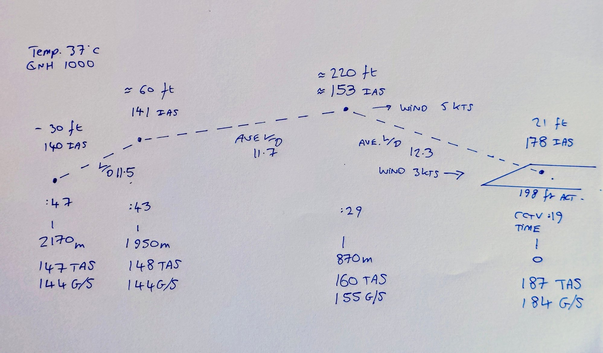
This energy-based model illustrates Air India 171's flight profile from liftoff to impact. It uses the initial data point from FlightRadar24 of 184 kts G/S, 21 ft height, Google Earth for the crash location, and CCTV footage (originally posted on X) for timing.
A key observation is the calculated average ground speed of 150 knots from the initial point, just after takeoff, to the crash site, derived using the CCTV elapsed time. The model incorporates "best-guess" mid-points inferred from the CCTV footage, which help depict approximate indicated airspeeds consistent with the aircraft's energy state throughout the flight.
The analysis assumes zero thrust during the flight and an average Lift-to-Drag ratio of approximately 12. For this model, a takeoff mass of 210 tonnes and an estimated V2 of 160 knots were used.
Note: This analysis was conducted prior to the release of the AAIB preliminary report, and therefore does not account for the correct take off mass and the actual V2 of 162. The differences are small and as this is a rough best guess, it\x92s just a basic energy model to show the possible trade between speed and height. No account was made of an engine spooling up at the end of the flight. Visual review of the video suggests the thrust from any restarting engine must have been very low, as no significant yaw is discernible.
Subjects
AAIB (All)
CCTV
FlightRadar24
Preliminary Report
V2
Links are to this post in the relevant subject page so that this post can be seen in context.
Reply to this quoting this original post. You need to be logged in. Not available on closed threads.