July 16, 2025, 02:55:00 GMT
permalink Post: 11923383
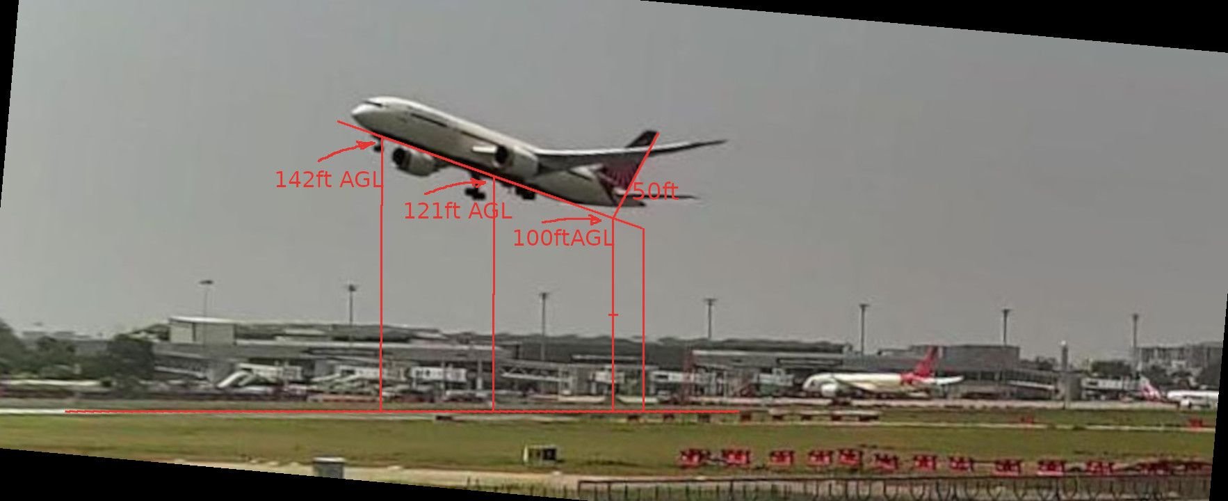
Baro altitude should be around 150ft; using the public cctv video, I estimate this picture was taken between 4-7 seconds after rotation. A wide range, but that was the best estimate I could come up with. Maybe someone else could narrow it down further.
1. ADSB readouts - according to FlightRadar24, the last ADSB transmission was at 71ft AGL. Is that significant given the RAT is seen already deployed at 150ft AGL per the estimate above? At 71ft AGL, the wheels are about 40-50ft off the ground, assuming aircraft attitude is unchanged between there and this image. Is that 1 or 2 seconds after rotation? Does this imply electrical issues?
1a. The timings for ADSB transmissions outlined by MrShed are not in sync with the estimates above - people have talked about a time shift in this thread. I do believe ADSB timestamps are by the receiving station.
2. The preliminary report timings from the EAFR for E2 fuel cutoff switch RUN -> CUTOFF to the RAT supplying hydraulic power disagree with the lower end of the 4-7s estimate above, and are only consistent if this picture was taken 6-7 seconds after rotation, in my opinion, because of the time (4-5s) it would take to cut off the fuel to E2, spool down to where the VFSGs stop providing AC power, and RAT deployment.
3. The Preliminary Report mentions that the RAT deployed "immediately after" lift-off. Again, I have to wonder, why didn't they provide the RAT deployment timestamp, even relative to rotation? If this is in fact the case, does this imply electrical issues, in line with the last ADSB altitude reading?
FR24 article https://www.flightradar24.com/blog/f...rom-ahmedabad/
Last edited by appruser; 16th July 2025 at 02:57 . Reason: Added link to FR24 blog post
Subjects
ADSB
EAFR
FlightRadar24
Fuel (All)
Fuel Cutoff
Fuel Cutoff Switches
Hydraulic Failure (All)
Preliminary Report
RAT (All)
RAT (Deployment)
RUN/CUTOFF
Links are to this post in the relevant subject page so that this post can be seen in context.
Reply to this quoting this original post. You need to be logged in. Not available on closed threads.
July 16, 2025, 04:52:00 GMT
permalink Post: 11923409
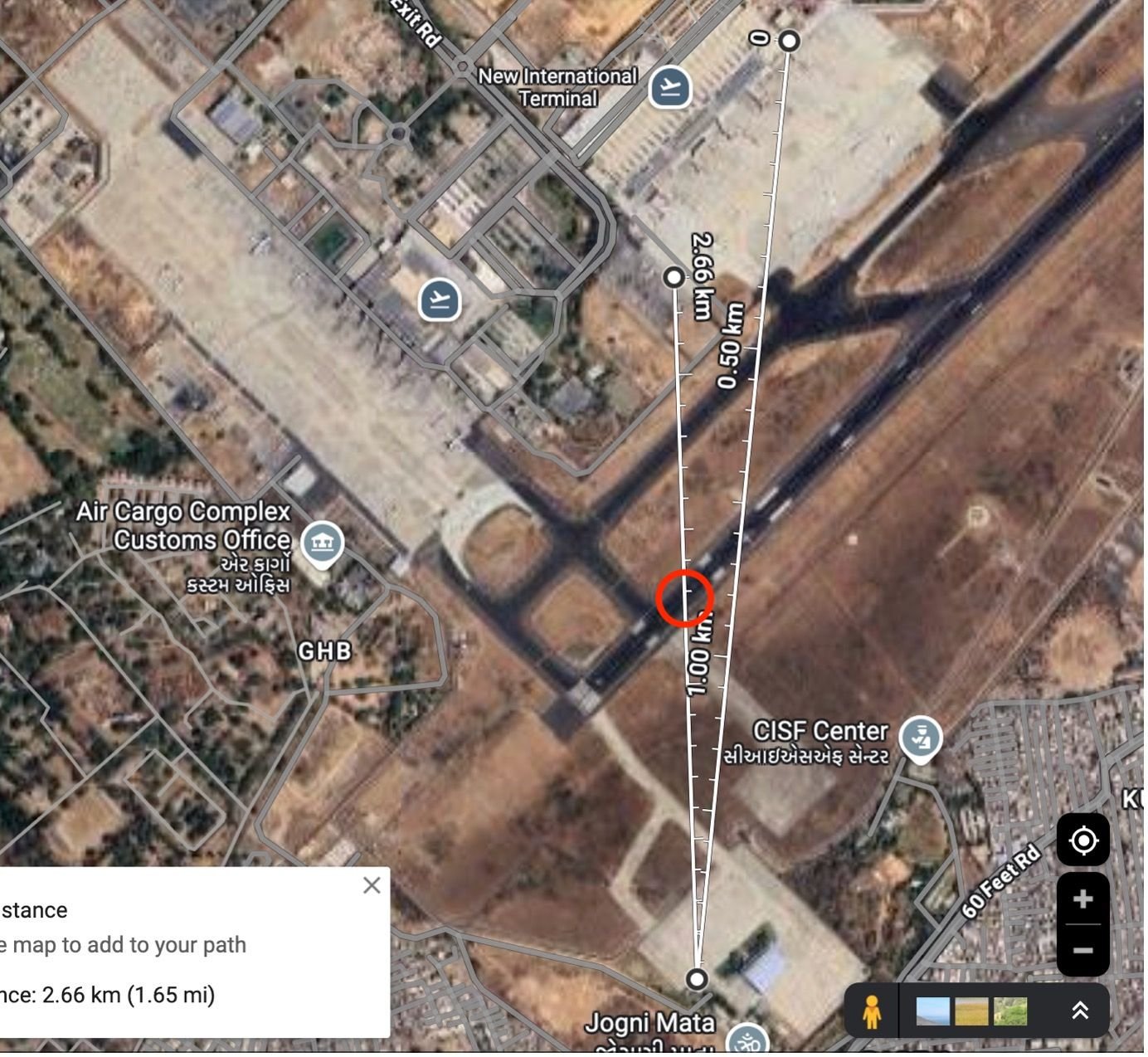
The deemed position of the CCTV camera is only an estimate, based on visual cues. I'm happy to share my workings, should anyone find it useful to cross-reference this with other data they are working on, but I will avoid cluttering up the thread any further until/unless it becomes relevant.
You're looking for the point where the LEFT of the two white lines intersects the runway (ignore the white dots):
1. ADSB readouts - according to FlightRadar24, the last ADSB transmission was at 71ft AGL. Is that significant given the RAT is seen already deployed at 150ft AGL per the estimate above? At 71ft AGL, the wheels are about 40-50ft off the ground, assuming aircraft attitude is unchanged between there and this image. Is that 1 or 2 seconds after rotation? Does this imply electrical issues?
1a. The timings for ADSB transmissions outlined by MrShed are not in sync with the estimates above - people have talked about a time shift in this thread. I do believe ADSB timestamps are by the receiving station.
2. The preliminary report timings from the EAFR for E2 fuel cutoff switch RUN -> CUTOFF to the RAT supplying hydraulic power disagree with the lower end of the 4-7s estimate above, and are only consistent if this picture was taken 6-7 seconds after rotation, in my opinion, because of the time (4-5s) it would take to cut off the fuel to E2, spool down to where the VFSGs stop providing AC power, and RAT deployment.
3. The Preliminary Report mentions that the RAT deployed "immediately after" lift-off. Again, I have to wonder, why didn't they provide the RAT deployment timestamp, even relative to rotation? If this is in fact the case, does this imply electrical issues, in line with the last ADSB altitude reading?
FR24 article https://www.flightradar24.com/blog/f...rom-ahmedabad/
Note that the good folks at FR24 did not apply temperature correction to the barometric altitude (they corrected for air pressure and runway elevation); pilots on pprune have done the corrections themselves and arrived at slightly different values, so take those altitude numbers with a grain of salt. Note also that the 787 sends altitude in 25 ft. increments, and I don't know how these are rounded (up, down, nearest).
We do not know how long the RAT has been deployed in this photo, we only know it can't have been deployed later. I have learned on this thread that the CUTOFF switch will also cause the VFSGs to disconnect, i.e. the B787 systems will electrically isolate the engine from the power buses before it has spooled down. With a dual failure, this would leave the main buses unpowered in short order, so if all of this is correct, the RAT would have clonked into place very soon after the second engine was cut off. This would not depend on the turbine speed.
I personally do not know what items are logged on the flight recorder, but I imagine RAT deployment was not among them. If so, the conditions for its deployment would be logged, but it requires an analytical step to conclude it did, and a preliminary report typically has no analysis at all. Hydraulic pressure to the flight controls is likely logged, so the RAT delivering hydraulic power would be a matter of record.
Where is the RadAlt antenna on a 787? Is it in the nose, or further back between the main gears?
Last edited by Musician; 16th July 2025 at 05:02 .
Subjects
ADSB
CCTV
DFDR
EAFR
FlightRadar24
Fuel (All)
Fuel Cutoff
Fuel Cutoff Switches
Hydraulic Failure (All)
Preliminary Report
RAT (All)
RAT (Deployment)
RUN/CUTOFF
Links are to this post in the relevant subject page so that this post can be seen in context.
Reply to this quoting this original post. You need to be logged in. Not available on closed threads.
July 17, 2025, 06:27:00 GMT
permalink Post: 11924133
I think everyone agrees that the preliminary report contains sufficient evidence to start a criminal investigation. What this thread is in two minds about is whether the outcome of a criminal investigation is a foregone conclusion.
Subjects
FlightRadar24
Preliminary Report
Wall Street Journal
Links are to this post in the relevant subject page so that this post can be seen in context.
Reply to this quoting this original post. You need to be logged in. Not available on closed threads.
July 17, 2025, 09:36:00 GMT
permalink Post: 11924223
I think everyone agrees that the preliminary report contains sufficient evidence to start a criminal investigation. What this thread is in two minds about is whether the outcome of a criminal investigation is a foregone conclusion.
Subjects
FlightRadar24
Preliminary Report
Links are to this post in the relevant subject page so that this post can be seen in context.
Reply to this quoting this original post. You need to be logged in. Not available on closed threads.
July 18, 2025, 01:25:00 GMT
permalink Post: 11924773
So in the diagram (can't modify right now but I will), the blue bar starts at 5 and ends at 13, max altitude marker at 8.
That would tie in with loss of power.
It would put, interestingly, engine cutoffs right at the earliest opportunity within the window available with sampling etc.
(Incidentally an apology to Musician who I incorrectly told earlier that such a movement would be inconsistent with max altitude record, I can see clearly now this isn't the case!).
I think for various reasons the ADSB data's absolute values are offset by some amount, for possibly all of the parameters. But there should be consistency in the deltas for the timestamp (by receiving station), the raw baro altitude, the Flightradar24 AGL values, and the airspeed. Flightradar24 themselves note that for altitude " ... the data is not above ground level, but it is consistent to itself."
08:08:46.55 ... 575ft ... 21ft ... 184kt
08:08:48.14 ... 600ft ... 46ft ... 179kt
08:08:48.61 ... 600ft ... 46ft ... 177kt
08:08:49.01 ... 600ft ... 46ft ... 177kt
08:08:49.46 ... 625ft ... 71ft ... 177kt
08:08:49.92 ... 625ft ... 71ft ... 174kt
08:08:50.39 ... 625ft ... 71ft ... 174kt
08:08:50.87 ... 625ft ... 71ft ... 172kt
From the Preliminary Report's airport cctv picture, the RAT was seen deployed at, by my estimate here , 150ft baro altitude, between 4-7 seconds after rotation. So the ADSB readings have to be prior to that.
What's interesting is that the ADSB data covers:
- 4-5 seconds of time (let's approximate 4 seconds from 46.55 to 50.55, ignoring the 0.32s for the moment)
- 50ft of altitude gain
- Declining airspeed from the 1st reading to the last in this final segment from the runway.
Big questions in my mind:
1. If the loss of ADSB corresponds to the E1/E2Fuel Cutoff switches being moved from RUN -> CUTOFF, why is the airspeed declining for the prior 4 seconds?
2. In 4 seconds, why is there only 50ft of altitude gain? that seems odd.
3. To account for only 50ft of alt gain, if we assume the 1st reading is on the runway just before rotation, the intermediate +25ft alt gain is at rotation (Nose up but MLG still on the runway), and the last 4 readings are in the air (nose up an additional 25ft), that means that 1 second or less after lift-off, ADSB was lost - this is before E1/E2 FCO RUN-> CUTOFF.
It's just weird .
Last edited by appruser; 18th July 2025 at 01:41 . Reason: added a comma for clarity
Subjects
ADSB
FlightRadar24
Fuel (All)
Fuel Cutoff Switches
Parameters
RAT (All)
RAT (Deployment)
RUN/CUTOFF
Links are to this post in the relevant subject page so that this post can be seen in context.
Reply to this quoting this original post. You need to be logged in. Not available on closed threads.
July 18, 2025, 02:32:00 GMT
permalink Post: 11924794
I think for various reasons the ADSB data's absolute values are offset by some amount, for possibly all of the parameters. But there should be consistency in the deltas for the timestamp (by receiving station), the raw baro altitude, the Flightradar24 AGL values, and the airspeed. Flightradar24 themselves note that for altitude " ... the data is not above ground level, but it is consistent to itself."
08:08:46.55 ... 575ft ... 21ft ... 184kt
08:08:48.14 ... 600ft ... 46ft ... 179kt
08:08:48.61 ... 600ft ... 46ft ... 177kt
08:08:49.01 ... 600ft ... 46ft ... 177kt
08:08:49.46 ... 625ft ... 71ft ... 177kt
08:08:49.92 ... 625ft ... 71ft ... 174kt
08:08:50.39 ... 625ft ... 71ft ... 174kt
08:08:50.87 ... 625ft ... 71ft ... 172kt
From the Preliminary Report's airport cctv picture, the RAT was seen deployed at, by my estimate here , 150ft baro altitude, between 4-7 seconds after rotation. So the ADSB readings have to be prior to that.
What's interesting is that the ADSB data covers:
- 4-5 seconds of time (let's approximate 4 seconds from 46.55 to 50.55, ignoring the 0.32s for the moment)
- 50ft of altitude gain
- Declining airspeed from the 1st reading to the last in this final segment from the runway.
Big questions in my mind:
1. If the loss of ADSB corresponds to the E1/E2Fuel Cutoff switches being moved from RUN -> CUTOFF, why is the airspeed declining for the prior 4 seconds?
2. In 4 seconds, why is there only 50ft of altitude gain? that seems odd.
3. To account for only 50ft of alt gain, if we assume the 1st reading is on the runway just before rotation, the intermediate +25ft alt gain is at rotation (Nose up but MLG still on the runway), and the last 4 readings are in the air (nose up an additional 25ft), that means that 1 second or less after lift-off, ADSB was lost - this is before E1/E2 FCO RUN-> CUTOFF.
It's just weird .
The widely watched video shows a very normal initial rotation and climb.
Subjects
ADSB
FlightRadar24
Fuel (All)
Fuel Cutoff Switches
Hydraulic Failure (All)
Parameters
RAT (All)
RAT (Deployment)
RUN/CUTOFF
Links are to this post in the relevant subject page so that this post can be seen in context.
Reply to this quoting this original post. You need to be logged in. Not available on closed threads.
July 18, 2025, 06:07:00 GMT
permalink Post: 11924844
I think for various reasons the ADSB data's absolute values are offset by some amount, for possibly all of the parameters. But there should be consistency in the deltas for the timestamp (by receiving station), the raw baro altitude, the Flightradar24 AGL values, and the airspeed. Flightradar24 themselves note that for altitude " ... the data is not above ground level, but it is consistent to itself."
08:08:46.55 ... 575ft ... 21ft ... 184kt
08:08:48.14 ... 600ft ... 46ft ... 179kt
08:08:48.61 ... 600ft ... 46ft ... 177kt
08:08:49.01 ... 600ft ... 46ft ... 177kt
08:08:49.46 ... 625ft ... 71ft ... 177kt
08:08:49.92 ... 625ft ... 71ft ... 174kt
08:08:50.39 ... 625ft ... 71ft ... 174kt
08:08:50.87 ... 625ft ... 71ft ... 172kt
From the Preliminary Report's airport cctv picture, the RAT was seen deployed at, by my estimate here , 150ft baro altitude, between 4-7 seconds after rotation. So the ADSB readings have to be prior to that.
What's interesting is that the ADSB data covers:
- 4-5 seconds of time (let's approximate 4 seconds from 46.55 to 50.55, ignoring the 0.32s for the moment)
- 50ft of altitude gain
- Declining airspeed from the 1st reading to the last in this final segment from the runway.
Big questions in my mind:
1. If the loss of ADSB corresponds to the E1/E2Fuel Cutoff switches being moved from RUN -> CUTOFF, why is the airspeed declining for the prior 4 seconds?
2. In 4 seconds, why is there only 50ft of altitude gain? that seems odd.
3. To account for only 50ft of alt gain, if we assume the 1st reading is on the runway just before rotation, the intermediate +25ft alt gain is at rotation (Nose up but MLG still on the runway), and the last 4 readings are in the air (nose up an additional 25ft), that means that 1 second or less after lift-off, ADSB was lost - this is before E1/E2 FCO RUN-> CUTOFF.
It's just weird .
Subjects
ADSB
FlightRadar24
Fuel (All)
Fuel Cutoff Switches
Parameters
RAT (All)
RAT (Deployment)
RUN/CUTOFF
Links are to this post in the relevant subject page so that this post can be seen in context.
Reply to this quoting this original post. You need to be logged in. Not available on closed threads.
July 18, 2025, 06:18:00 GMT
permalink Post: 11924846
1. If the loss of ADSB corresponds to the E1/E2Fuel Cutoff switches being moved from RUN -> CUTOFF, why is the airspeed declining for the prior 4 seconds?
2. In 4 seconds, why is there only 50ft of altitude gain? that seems odd.
3. To account for only 50ft of alt gain, if we assume the 1st reading is on the runway just before rotation, the intermediate +25ft alt gain is at rotation (Nose up but MLG still on the runway), and the last 4 readings are in the air (nose up an additional 25ft), that means that 1 second or less after lift-off, ADSB was lost - this is before E1/E2 FCO RUN-> CUTOFF.
It's just weird .
2. Altitudes are rounded, so this could be close to 75 feet gain‐‐or a gain and decline, if the data covers the top of the trajectory.
3. The first reading is definitely in the air, after rotation. FR24 does not report the altitude when the ADS-B data indicates that the aircraft is on the ground, and their data download confirms that.
The best bet to establish timing is to use rotation as datum, and then match the altitude/time estimates from the CCTV with position/time from the ADS-B and the estimated ground speed of the aircraft.
The fact that the ground speed is declining throughout the data sequence strongly suggests that it begins some time after the point, or at the point, when thrust was lost. And we know that didn't begin to happen until the aircraft was 3 seconds into the air.
Last edited by Musician; 18th July 2025 at 06:38 .
Subjects
ADSB
CCTV
FlightRadar24
Fuel (All)
Fuel Cutoff Switches
RUN/CUTOFF
Links are to this post in the relevant subject page so that this post can be seen in context.
Reply to this quoting this original post. You need to be logged in. Not available on closed threads.
February 02, 2026, 15:04:00 GMT
permalink Post: 12031129
According to FR24.
The aircraft took off 35 minutes late.
So we are being led to believe that a potentially critical system failure was observed during engine start, subsequently ignored, the aircraft operated it's scheduled service back to India.
Alternatively, the #1 fuel cut off switch was replaced, system checks, including an engine start, performed and certified, all in 35 minutes or less?
I smell a rat.
Subjects
FlightRadar24
Fuel (All)
Fuel Cutoff
Fuel Cutoff Switches
Links are to this post in the relevant subject page so that this post can be seen in context.
Reply to this quoting this original post. You need to be logged in. Not available on closed threads.
February 02, 2026, 15:16:00 GMT
permalink Post: 12031137
According to FR24.
The aircraft took off 35 minutes late.
So we are being led to believe that a potentially critical system failure was observed during engine start, subsequently ignored, the aircraft operated it's scheduled service back to India.
Alternatively, the #1 fuel cut off switch was replaced, system checks, including an engine start, performed and certified, all in 35 minutes or less?
I smell a rat.
and they continued on with no other dramas to their home base where the plane is now in the hands of maintenance
clearly *something* happened as I don\x92t think airlines are on the habit of grounding their $300m airliners for no reason.
i remember when the consensus was this issue (fuel cutoffs not seating properly) was nearly impossible yet this crew found differently.
maybe we should discuss new information on the merits of that and not frame everything as x party trying to shift blame
this is certainly noteworthy even if it ultimately has nothing to do with 171
Subjects
FlightRadar24
Fuel (All)
Fuel Cutoff
Fuel Cutoff Switches
Links are to this post in the relevant subject page so that this post can be seen in context.
Reply to this quoting this original post. You need to be logged in. Not available on closed threads.
February 02, 2026, 23:21:00 GMT
permalink Post: 12031352
According to FR24.
The aircraft took off 35 minutes late.
So we are being led to believe that a potentially critical system failure was observed during engine start, subsequently ignored, the aircraft operated it's scheduled service back to India.
Alternatively, the #1 fuel cut off switch was replaced, system checks, including an engine start, performed and certified, all in 35 minutes or less?
I smell a rat.
Subjects
FlightRadar24
Fuel (All)
Fuel Cutoff
Fuel Cutoff Switches
Links are to this post in the relevant subject page so that this post can be seen in context.
Reply to this quoting this original post. You need to be logged in. Not available on closed threads.
February 03, 2026, 01:33:00 GMT
permalink Post: 12031381
But yes, the fact it only left 14 minutes late suggests they did nothing about a fault that could potentially cause an engine to shut down.
Unbelievable!
What a shoddy outfit.
Subjects
FlightRadar24
Links are to this post in the relevant subject page so that this post can be seen in context.
Reply to this quoting this original post. You need to be logged in. Not available on closed threads.