February 18, 2025, 08:00:00 GMT
permalink Post: 11830516
I wouldn't put it past the FAA to pull a stunt like that, read Mary Schiavo's (ex IG of the Dept. of Transportation) book if you want to know how wily they can be. And Jennifer gave them the perfect lay up in the last briefing.
It's way to easy to blame the pilots, over the years there have been incidents due to incorrect QNH settings, were both pilots and ATC have failed to catch the error, in a busy airspace with overworked ATC, late change of runway for airlines, and military helicopters using Night Vision Goggles, altimeter equipment failure/error.
Even the Max 200 ft altitude under the approach to a major US airport is an accident waiting to happen, and whoever approved this to be used during normal operations should be investigated. The CRJ was at around 325 ft on a visual/circling approach when it crashed, does anyone really think it's great airmanship to have a Black Hawk helicopter at 200 ft passing under you?
That's what made the Swiss Cheese model line up perfectly, a planned approved separation of 125 ft was the "best case" scenario.
Subjects
ATC
Accident Waiting to Happen
Altimeter (All)
Blackhawk (H-60)
CRJ
FAA
QNH
Separation (ALL)
Links are to this post in the relevant subject page so that this post can be seen in context.
Reply to this quoting this original post. You need to be logged in. Not available on closed threads.
February 20, 2025, 08:54:00 GMT
permalink Post: 11832026
A published glideslope (usually nowadays defined by ILS or GPS) is predicated on HEIGHT above the touchdown point , ie it is a physically fixed plane referenced to the ground. How the altimeter is set is completely irrelevant to an aircraft on the glideslope from that point of view. But this aeroplane was on a visual aproach so altimetry is also irrelevant as it is not constrained by a rigidly defined instrumented glideslope.
While the helilane limit is, technically, predicated on an altitude that's really just semantics in this case as it is over water that is at sea level and as any PPL should know that gives height above sea level with QNH set. Thus to all practical intents and purposes the heli routes are flown at heights, and as the rad alt is an order of magnitide more accutate than a bar-alt pilots will likely set its bug at 200ft and and such a low level as this where bar-alt inaccuracy is very significant will (or should) fly that, despite having set QNH because that's the requirement. That way both aircraft are on the same plane of reference, ie vs. the ground = height.
The graphic above is surprising illustration of how a lateral error of just 200m puts a helo firmly into the acceptable glideslope parameters and surely demonstrates more clearly than anything else we've seen the insanity, even irresponsibility of the design of this piece of airspace. Mind, get 200m off track in the vicinity of Heathrow, let alone crossing it and you'll be ordered out of the system the way you came in with a telephone number to call...
Still no word on why this route couldn't have been designed with a sensible vertical separation above the f/w flightpath, someone must know.
Subjects
Altimeter (All)
QNH
Radio Altimeter
Separation (ALL)
Vertical Separation
Links are to this post in the relevant subject page so that this post can be seen in context.
Reply to this quoting this original post. You need to be logged in. Not available on closed threads.
March 30, 2025, 21:14:00 GMT
permalink Post: 11857550
The altitude is still uncertain because of difference between jet and heli values and destruction of the heli altimeter. So work on that is continuing with a focus on other sources.
But note the 75 ft separation is a maximum. So if the heli was at 200ft then it was on the glide slope.
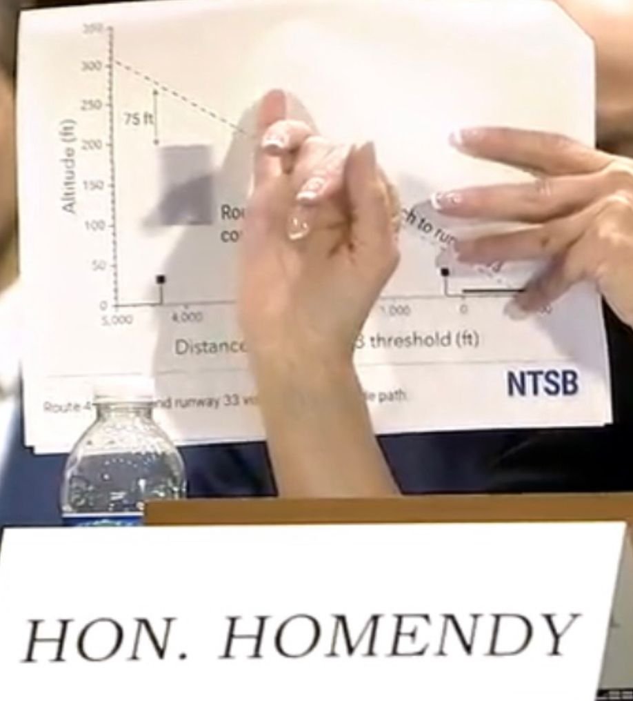
Another interesting point is that mixed heli and fixed wing is forbidden in the yellow zone (permanently), and ADSB mandatory in the red zone. With routes 4 and 6 cut.
See post below
Last edited by A0283; 30th March 2025 at 21:25 .
Subjects
ADSB (All)
Altimeter (All)
Close Calls
NTSB
Separation (ALL)
Links are to this post in the relevant subject page so that this post can be seen in context.
Reply to this quoting this original post. You need to be logged in. Not available on closed threads.
July 31, 2025, 19:00:00 GMT
permalink Post: 11931499
(I need to see a bit more of the documentation on the difference between the hard altitude (200') that I was under the impression was on that route, as opposed to the "recommended altitude" statement made there...maybe it will make more sense to me then).
As to altimeter errors.
The UH-60L has a radalt.
Are you trying to tell me that the alleged acceptable error for a rad alt is 80'-130'?
I think not.
I doubt that the rules have changed that much since I was last flying a Blackhawk. (yes, it has been a while).
Will do a bit more reading, thanks.
Subjects
ATC
Altimeter (All)
Blackhawk (H-60)
Radio Altimeter
VFR
Links are to this post in the relevant subject page so that this post can be seen in context.
Reply to this quoting this original post. You need to be logged in. Not available on closed threads.
July 31, 2025, 19:18:00 GMT
permalink Post: 11931506
For TF/TA radalt is the go-to instrument, but for coordinating multiple aircraft to maintain vertical separation, barometric altitude is more suitable. The problem being that barometric altimeters are subject to a lot of measurement and reporting errors.
I am sure that GPS-RTK could be used to fix the absolute altitude with great precision, but I am also sure that depending on an easily denied measurement source on a military aircraft is not going happen.
The correct solution for operating in a civilian airspace is to use ADS-B In/Out for all manned aircraft to provide appropriate and timely situational awareness. While ADS-B is also subject to denial, it offers far greater benefit in civilian airspace over GPS-RTK in that it tells the pilots where all the other aircraft are rather than simply being more precise about where their own aircraft is.
It is clear that the helicopter crew not knowing where the passenger jet was was the primary cause of the collision.
Arguments about the error in the altimeter readings are suitable to emphasize that depending on them in a crowded airspace is a fool's choice and should have been spotted a long time ago as insufficient to provide clearance.
Subjects
ADSB (All)
Altimeter (All)
Radio Altimeter
Separation (ALL)
Situational Awareness
Vertical Separation
Links are to this post in the relevant subject page so that this post can be seen in context.
Reply to this quoting this original post. You need to be logged in. Not available on closed threads.
July 31, 2025, 23:36:00 GMT
permalink Post: 11931584
EDIT: I also appreciate the arriving jet was on a geometric glide slope and that radalt under the glideslope could have been sufficient, but if one is expecting that vertical separation is sufficient then there needs to be certainty to that altitude and clearly that isn't possible on barometric altimeter and should never have been accepted by anyone.
Last edited by MechEngr; 1st August 2025 at 05:39 .
Subjects
AA5342
Altimeter (All)
Barometric Altimeter
Radio Altimeter
Separation (ALL)
Vertical Separation
Links are to this post in the relevant subject page so that this post can be seen in context.
Reply to this quoting this original post. You need to be logged in. Not available on closed threads.
August 01, 2025, 15:56:00 GMT
permalink Post: 11931914
There's a reason for the normal 500' or 1000' separation between traffic, eg enroute cruising altitudes. Someone once worked out the tolerances and margins.
Subjects
ATC
Altimeter (All)
Separation (ALL)
Links are to this post in the relevant subject page so that this post can be seen in context.
Reply to this quoting this original post. You need to be logged in. Not available on closed threads.
August 01, 2025, 20:09:00 GMT
permalink Post: 11932030
To complicate further, the Army Day 1 witness, CW4 Lewis, indicated she would have flown route 1/4 using radalt as her altitude reference. She also offered that she had zero DC route experience.
It was her.
Lewis: In my experience, when flying at low altitude, I would be referencing the radar altimeter.
Mueller: And when would you transition roughly between the two?
Lewis: In my experience, certainly 200 feet and below, I would be referencing the radar altimeter. However, if I was flying on a published MSL route, I would be referencing barometric altitude.
and later
(unsure): This is a scenario based, one based on what the chairman asked about flying over the Potomac River route. If you had a route ceiling of about 200 feet and you were to look at your barometric altimeter and see about 160 feet, but then it's all on your radar altimeter, about 280 feet. How would you triage that situation in your experience?
Lewis: So if the barometric altimeter is reading 160 feet, you're saying and the radar altimeter is reading significantly higher than that, I would still my primary concern on the MSL route would be staying below the 200 feet. And I would definitely, you know, take note of that and and maybe write the aircraft up for some, you know, maintenance action. But at that particular time I would as long as there was nothing wrong with the aircraft before we took off. As far as the field elevation and barometric altimeter, I would, you know, continue to assume that I was below that 200 foot MSL.
Subjects
Altimeter (All)
Barometric Altimeter
Radar
Radio Altimeter
Links are to this post in the relevant subject page so that this post can be seen in context.
Reply to this quoting this original post. You need to be logged in. Not available on closed threads.
August 03, 2025, 16:13:00 GMT
permalink Post: 11932824
(I need to see a bit more of the documentation on the difference between the hard altitude (200') that I was under the impression was on that route, as opposed to the "recommended altitude" statement made there...maybe it will make more sense to me then).
As to altimeter errors.
The UH-60L has a radalt.
Are you trying to tell me that the alleged acceptable error for a rad alt is 80'-130'?
I think not.
I doubt that the rules have changed that much since I was last flying a Blackhawk. (yes, it has been a while).
Will do a bit more reading, thanks.
Subjects
Altimeter (All)
Blackhawk (H-60)
Radar
Radio Altimeter
Links are to this post in the relevant subject page so that this post can be seen in context.
Reply to this quoting this original post. You need to be logged in. Not available on closed threads.
August 09, 2025, 14:57:00 GMT
permalink Post: 11935746
But it seems military helicopters are not subject to the civil requirements - which is acceptable until these helicopters enter civil regulated airspace where heretofore unexamined databases show a litany of CAs that were neglected.
Static port issues in rotor downwash seem to produce significant altimeter errors.
Subjects
Altimeter (All)
Links are to this post in the relevant subject page so that this post can be seen in context.
Reply to this quoting this original post. You need to be logged in. Not available on closed threads.
August 09, 2025, 16:03:00 GMT
permalink Post: 11935775
But it seems military helicopters are not subject to the civil requirements - which is acceptable until these helicopters enter civil regulated airspace where heretofore unexamined databases show a litany of CAs that were neglected.
Static port issues in rotor downwash seem to produce significant altimeter errors.
Subjects
Altimeter (All)
FAA
ICAO
Links are to this post in the relevant subject page so that this post can be seen in context.
Reply to this quoting this original post. You need to be logged in. Not available on closed threads.
August 09, 2025, 17:05:00 GMT
permalink Post: 11935810
Subjects
Altimeter (All)
NTSB Docket
PAT25
Links are to this post in the relevant subject page so that this post can be seen in context.
Reply to this quoting this original post. You need to be logged in. Not available on closed threads.
August 09, 2025, 23:12:00 GMT
permalink Post: 11935939
Subjects
Altimeter (All)
Links are to this post in the relevant subject page so that this post can be seen in context.
Reply to this quoting this original post. You need to be logged in. Not available on closed threads.
August 10, 2025, 05:00:00 GMT
permalink Post: 11936009
I strikes me that, from my layman’s point of view, that this is the primary and gaping hole (among numerous others) in the Swiss cheese here.
At the same time, I get the sense that no controller was ever going to intentionally permit a helicopter to pass directly under an approaching aircraft and challenge that limited clearance.
My question is, should this have been (or was it?) formalized as an ATC procedure? Because if this had been proceduralized, I find it hard to believe that just nighttime VFR separation would have been found acceptable in that environment. Rather I would think that lateral separation should have been actively managed by ATC.
For one thing, with the CRJ (or whatever aircraft) pilots making a late switch to 33, turning to line up with the runway, etc., they may not have had the bandwidth to scan for a possibly conflicting helicopter, if they could even have seen it from their cockpit. (IIRC from the inquiry, the NTSB will be investigating that last point.)
I don’t know how difficult it may have been for the helicopter to see the CRJ, but the simple fact is that they did not.
On another subject, one thing that struck me from the inquiry was that the helicopter pilot apparently had very limited recent flight time, yet was assigned a challenging check ride.
This contrasted with the testimony of the leader (?) of one of the local Medivac groups, who discussed how much more experience he and his pilots had flying in that challenging environment (and often single-pilot ops at that).
Is the Army not providing adequate training and flight time to ensure their pilots can operate safely in those conditions?
Last edited by andihce; 10th August 2025 at 06:44 . Reason: clarification
Subjects
ATC
Altimeter (All)
CRJ
NTSB
Route 4
Separation (ALL)
VFR
Vertical Separation
Links are to this post in the relevant subject page so that this post can be seen in context.
Reply to this quoting this original post. You need to be logged in. Not available on closed threads.
August 10, 2025, 06:10:00 GMT
permalink Post: 11936017
I strikes me that, from my layman\x92s point of view, that this is the primary and gaping hole (among numerous others) in the Swiss cheese here.
At the same time, I get the sense that no controller was ever going to allow a helicopter to pass directly under an approaching aircraft and challenge that limited clearance.
My question is, should this have been (or was it?) formalized as an ATC procedure? Because if this had been proceduralized, I find it hard to believe that just nighttime VFR separation would have been found acceptable in that environment. Rather I would think that lateral separation should have been actively managed by ATC.
For one thing, with the CRJ (or whatever aircraft) pilots making a late switch to 33, turning to line up with the runway, etc., they may not have had the bandwidth to scan for a possibly conflicting helicopter, if they could even have seen it from their cockpit. (IIRC from the inquiry, the NTSB will be investigating that last point.)
I don\x92t know how difficult it may have been for the helicopter to see the CRJ, but the simple fact is that they did not.
And to stick with motoring analogies, some of us are used to considering that at a junction another vehicle can be partly obscured by a pillar for one eye, and in the blind spot of our other eye, so we might move our head sideways to help check better. Some aircraft have more windscreen pillars (this helicopter has four) so the aircraft in a constant relative position - which is the one that is the collision risk - may stay behind a pillar unless we move our head.
Subjects
ATC
Altimeter (All)
CRJ
NTSB
Route 4
Separation (ALL)
VFR
Vertical Separation
Links are to this post in the relevant subject page so that this post can be seen in context.
Reply to this quoting this original post. You need to be logged in. Not available on closed threads.
August 10, 2025, 06:48:00 GMT
permalink Post: 11936029
I strikes me that, from my layman\x92s point of view, that this is the primary and gaping hole (among numerous others) in the Swiss cheese here.
At the same time, I get the sense that no controller was ever going to allow a helicopter to pass directly under an approaching aircraft and challenge that limited clearance.
My question is, should this have been (or was it?) formalized as an ATC procedure? Because if this had been proceduralized, I find it hard to believe that just nighttime VFR separation would have been found acceptable in that environment. Rather I would think that lateral separation should have been actively managed by ATC.
Subjects
ATC
Altimeter (All)
Blackhawk (H-60)
CRJ
IFR
NTSB
Route 4
Separation (ALL)
Traffic in Sight
VFR
Vertical Separation
Visual Separation
Links are to this post in the relevant subject page so that this post can be seen in context.
Reply to this quoting this original post. You need to be logged in. Not available on closed threads.
October 21, 2025, 18:22:00 GMT
permalink Post: 11973780
Subjects
Altimeter (All)
FAA
Radio Altimeter
Route 4
Separation (ALL)
Links are to this post in the relevant subject page so that this post can be seen in context.
Reply to this quoting this original post. You need to be logged in. Not available on closed threads.
January 27, 2026, 23:09:00 GMT
permalink Post: 12028272
Their failure to regularly review and evaluate helicopter routes and available data, and their failure to act on recommendations to mitigate the risk of a mid-air collision near Ronald Reagan Washington National Airport, as well as the air traffic system's overreliance on visual separation.
In order to promote efficient traffic flow without consideration for the limitations of the see and avoid concept.
Also causal was the lack of effective pilot applied visual separation by the helicopter crew, which resulted in a mid-air collision.
Additional causal factors were were the tower team's loss of situational awareness and degraded performance due to a high workload of the combined helicopter and local control positions, and the absence of a risk assessment process to identify and mitigate real time operational risk factors, which resulted in miss prioritization of duties, inadequate traffic advisory advisories, and the lack of safety alerts to both flight crews.
Also causal was the Army's failure to ensure pilots were aware of the effects of air tolerances on barometric altimeter in their helicopters, which resulted in the crew flying above the maximum published helicopter route altitude.
Contributing factors include the limitations of the traffic awareness and collision alerting systems on both aircraft, which precluded effective alerting of the impending collision to the flight crew's.
An unsustainable airport arrival rate, increasing traffic volume with a changing fleet mix and airline scheduling practices at DCA, which regularly strain the DCA Atct workforce and degraded safety over time.
The Army's lack of a fully implemented safety management system, which should have identified and addressed hazards associated with altitude exceedances on the Washington, D.C. Helicopter routes.
The FAA's failure across multiple organizations to implement previous NTSB recommendations, including Ads-b in and to follow and fully integrate its established safety management system, which should have led to several organizational and operational changes based on previously identified risk that were known to management and the absence of effective data sharing and analysis among the FAA aircraft operators and other relevant organizations.
Subjects
Altimeter (All)
Barometric Altimeter
DCA
FAA
NTSB
Probable Cause
Route Altitude
See and Avoid
Separation (ALL)
Situational Awareness
Visual Separation
Links are to this post in the relevant subject page so that this post can be seen in context.
Reply to this quoting this original post. You need to be logged in. Not available on closed threads.
January 27, 2026, 23:41:00 GMT
permalink Post: 12028291
Subjects
Altimeter (All)
Barometric Altimeter
Blackhawk (H-60)
Route Altitude
Links are to this post in the relevant subject page so that this post can be seen in context.
Reply to this quoting this original post. You need to be logged in. Not available on closed threads.
January 29, 2026, 12:41:00 GMT
permalink Post: 12029104
You can find it here: https://paulross.github.io/pprune-th...DCA/index.html
All 1,829 posts are organised into 68 subjects.
Changes:
- Added link to NTSB findings, probable cause and final recommendations.
- Added subjects: 'Accountability/Liability', 'Findings', 'NTSB Docket', 'Barometric Altimeter', 'Route Altitude', 'Hot Spots', 'Final Report', 'Probable Cause', 'Safety Recommendations', 'Helicopter Working Group'.
The project is here: https://github.com/paulross/pprune-threads .
Issues can be raised here: https://github.com/paulross/pprune-threads/issues or PM me with ideas.
Subjects
Altimeter (All)
Barometric Altimeter
Final Report
Findings
Helicopter Working Group
Hot Spots
NTSB
NTSB Docket
Probable Cause
Route Altitude
Safety Recommendations
Links are to this post in the relevant subject page so that this post can be seen in context.
Reply to this quoting this original post. You need to be logged in. Not available on closed threads.